Page 100 of 103

Re: Texas Spring 2022

Posted: Tue May 24, 2022 6:32 pm
by EnnisTx
rwfromkansas wrote:.19.

And the rain coming in looks to be mostly for north metro. Bust again.


How is it a bust? It’s just cranking up.

Re: Texas Spring 2022

Posted: Tue May 24, 2022 6:34 pm
by Texas Snowman
Severe Weather Statement
National Weather Service Midland/Odessa TX
617 PM CDT Tue May 24 2022

TXC173-242345-
/O.CON.KMAF.TO.W.0015.000000T0000Z-220524T2345Z/
Glasscock TX-
617 PM CDT Tue May 24 2022

...A TORNADO WARNING REMAINS IN EFFECT UNTIL 645 PM CDT FOR
SOUTHEASTERN GLASSCOCK COUNTY...

At 616 PM CDT, a large and extremely dangerous tornado was located
near Garden City, moving east at 40 mph.

This is a PARTICULARLY DANGEROUS SITUATION. TAKE COVER NOW!

HAZARD...Damaging tornado.

SOURCE...Radar indicated rotation.

IMPACT...You are in a life-threatening situation. Flying debris may
be deadly to those caught without shelter. Mobile homes
will be destroyed. Considerable damage to homes,
businesses, and vehicles is likely and complete destruction
is possible.

The tornado will be near...
Garden City around 620 PM CDT.

PRECAUTIONARY/PREPAREDNESS ACTIONS...

To repeat, a large, extremely dangerous and potentially deadly
tornado is developing. To protect your life, TAKE COVER NOW! Move to
a basement or an interior room on the lowest floor of a sturdy
building. Avoid windows. If you are outdoors, in a mobile home, or in
a vehicle, move to the closest substantial shelter and protect
yourself from flying debris.

Torrential rainfall is occurring with this storm, and may lead to
flash flooding. Do not drive your vehicle through flooded roadways.

&&

LAT...LON 3180 10165 3192 10165 3189 10127 3165 10127
TIME...MOT...LOC 2316Z 287DEG 36KT 3184 10154

TORNADO...RADAR INDICATED
TORNADO DAMAGE THREAT...CONSIDERABLE
MAX HAIL SIZE...2.75 IN

Re: Texas Spring 2022

Posted: Tue May 24, 2022 6:41 pm
by Ntxw
Radar finally lit up for NTX. Central and SE/E Tx later tonight. Make or break time.

Re: Texas Spring 2022

Posted: Tue May 24, 2022 6:42 pm
by rwfromkansas
EnnisTx wrote:
rwfromkansas wrote:.19.

And the rain coming in looks to be mostly for north metro. Bust again.


How is it a bust? It’s just cranking up.


Below Denton it’s just a few skinny lines. It will take a ton to even get to an inch.

What may finally help is the line around Eastland. It’s stronger.

Re: Texas Spring 2022

Posted: Tue May 24, 2022 6:45 pm
by rwfromkansas
Glad Midland is getting rain finally, but that hail. Yikes.

Re: Texas Spring 2022

Posted: Tue May 24, 2022 6:58 pm
by Ntxw
Airport is cashing in with the mid cities band.
Re: Texas Spring 2022

Posted: Tue May 24, 2022 7:02 pm
by bubba hotep
It's been a while since we have seen a MCS event like this for Texas

Image

Image

Also, there was a big time rainfall event last night in South Texas with widespread 4-6" totals and a report of 10.57" near Santa Elena, Texas

Re: Texas Spring 2022

Posted: Tue May 24, 2022 7:05 pm
by bubba hotep
Ntxw wrote:Airport is cashing in with the mid cities band.


There is an West-East component developing over DFW with the more linear north-south line still out West. That could elevate totals across DFW as the primary line pushes eastward.

Re: Texas Spring 2022

Posted: Tue May 24, 2022 7:06 pm
by bubba hotep
Image

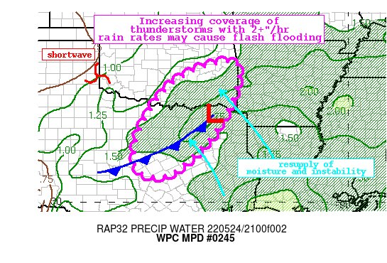
Mesoscale Precipitation Discussion 0245
NWS Weather Prediction Center College Park MD
741 PM EDT Tue May 24 2022

Areas affected...Northern Texas, Southeast Oklahoma

Concerning...Heavy rainfall...Flash flooding possible

Valid 242340Z - 250530Z

Summary...Showers and thunderstorms will expand in coverage across
parts of north Texas and spread into southeast Oklahoma this
evening. Rainfall rates of more than 2"/hr are likely, and
training of these rates could lead to flash flooding.

Discussion...An active evening of convection is ongoing across the
Southern Plains as multiple shortwaves and multiple boundaries
interact to drive widespread thunderstorm activity. A shortwave
noted on GOES-E WV imagery lifting out of the Texas Panhandle is
impinging upon a cold front draped from the Arklatex southwest
into the Edwards Plateau. Downstream of this shortwave, 850mb flow
is becoming locally backed according to the SPC RAP, and drawing
pronounced moisture and instability northward. Recent GPS
observations indicate PWs have surged above 1.5" from Dallas, TX
and points northeast, with MUCape south of the cold front
eclipsing 2000 J/kg. This locally backed flow is surging
orthogonally into the front, and then lifting isentropically into
North Texas, producing rounds of showers within this WAA regime
noted on the regional radar mosaic. West of this WAA precip, more
strongly forced thunderstorms along an outflow boundary and closer
to the shortwave are advecting eastward, with rain rates estimated
by KFWS WSR-88D of 1.5"/hr.

As the evening progresses, the cold front should gradually sag
southeastward while the LLJ increases to 20-30 kts but veers to
converge into the front rather than orthogonally lift atop it.
This will likely result in more boundary-parallel 0-6km mean
winds, while also turning Corfidi vectors to become more opposed
to this mean flow. Continued convergence along the front, combined
with modest PVA downstream of the shortwave and increasing
diffluence within the RRQ of an upper jet streak will allow
convection to expand further into southeast Oklahoma. With PWs
progged to remain at or above the 90th percentile, this expanding
convection will support rain rates which the HREF indicates could
reach 2"+/hr at times. While the mean wind will remain above 20
kts, the increasingly opposed Corfidi vectors suggest storms may
backbuild and then train along the front, prolonging the duration
of these excessive rain rates. This will likely lead to
significant rainfall accumulations, and the recent WoFS runs
continue to increase the probability for more than 3" of rainfall
in some areas.

This region has been dry noted by AHPS 7-day rainfall less than
10% of normal leading to NASA SPoRT 40cm soil moisture in the
bottom 10th percentile. However, the HREF does indicate areas with
a 10-30% chance for 1-hr and 3-hr FFG exceedance. Flash flooding
is possible, but would be most likely in any urban areas or where
any longer duration training can occur.


Weiss

ATTN...WFO...FWD...OUN...SHV...TSA...

ATTN...RFC...ABRFC...LMRFC...WGRFC...NWC...

Re: Texas Spring 2022

Posted: Tue May 24, 2022 7:08 pm
by Ntxw
bubba hotep wrote:
Ntxw wrote:Airport is cashing in with the mid cities band.


There is an West-East component developing over DFW with the more linear north-south line still out West. That could elevate totals across DFW as the primary line pushes eastward.


That's been the hope. Need the stuff east of Lubbock to dominate and prolong it.

Re: Texas Spring 2022

Posted: Tue May 24, 2022 8:14 pm
by mcallum177
Forgive my ignorance but the SPC meso analysis shows south winds at 925mb, 850, and 700mb why are the clouds in Rockwall moving from north to south? It seems like quite the opposite of what should be happening.

Re: Texas Spring 2022

Posted: Tue May 24, 2022 8:17 pm
by Ntxw
mcallum177 wrote:Forgive my ignorance but the SPC meso analysis shows south winds at 925mb, 850, and 700mb why are the clouds in Rockwall moving from north to south? It seems like quite the opposite of what should be happening.


Cold front blew through most of the metroplex, northerly winds. Lower ceilings would reflect.

Re: Texas Spring 2022

Posted: Tue May 24, 2022 8:21 pm
by mcallum177
so the wind moving the clouds is lower than 925mb like surface level?

Ntxw wrote:
mcallum177 wrote:Forgive my ignorance but the SPC meso analysis shows south winds at 925mb, 850, and 700mb why are the clouds in Rockwall moving from north to south? It seems like quite the opposite of what should be happening.


Cold front blew through most of the metroplex, northerly winds. Lower ceilings would reflect.

Re: Texas Spring 2022

Posted: Tue May 24, 2022 8:24 pm
by rwfromkansas
Alright; now we are talking. POURING!

Heaviest in a long time!

Re: Texas Spring 2022

Posted: Tue May 24, 2022 8:25 pm
by Ntxw
This band coming in is delivering quickly 1-3". Surprisingly the areas behind it are really raking up totals.

Re: Texas Spring 2022

Posted: Tue May 24, 2022 8:37 pm
by rwfromkansas
Holy cow. My station says 3 inch per hour rate. Already at an inch in 20 minutes.

Re: Texas Spring 2022

Posted: Tue May 24, 2022 8:43 pm
by Brent
About time y'all got some :lol:

Re: Texas Spring 2022

Posted: Tue May 24, 2022 8:46 pm
by Ntxw
No severe warnings in CWA. Just loads of rain.

Re: Texas Spring 2022

Posted: Tue May 24, 2022 8:47 pm
by EnnisTx
rwfromkansas wrote:Holy cow. My station says 3 inch per hour rate. Already at an inch in 20 minutes.


So much for that bust you were mentioning. Raining strait sideways here in Arlington with the wind howling.

Re: Texas Spring 2022

Posted: Tue May 24, 2022 8:58 pm
by gpsnowman
Wow what a line of storms. Heavy rain, wind , some thunder and lightning. Just glorious.