Had a Flood Advisory this evening after 1-2 inches fell in and around Denison and the northern part of Grayson County. My backyard was swamped—I’ll take it!
—————-
Flood Advisory
National Weather Service Fort Worth TX
825 PM CDT Tue Jun 6 2023
TXC097-181-070330-
/O.NEW.KFWD.FA.Y.0067.230607T0125Z-230607T0330Z/
/00000.N.ER.000000T0000Z.000000T0000Z.000000T0000Z.OO/
Cooke TX-Grayson TX-
825 PM CDT Tue Jun 6 2023
...FLOOD ADVISORY IN EFFECT UNTIL 1030 PM CDT THIS EVENING...
* WHAT...Urban and small stream flooding caused by excessive rainfall is expected.
* WHERE...A portion of north central Texas, including the following counties, Cooke and Grayson.
* WHEN...Until 1030 PM CDT.
* IMPACTS...Minor flooding in low-lying and poor drainage areas.
* ADDITIONAL DETAILS...
- Doppler radar indicated heavy rain due to thunderstorms. This will likely cause urban and small stream flooding. Low lying and/or poor drainage areas will experience minor flooding in the advisory area. Between 1 and 2 inches of rain have fallen. Additional rainfall amounts up to 1 inch are possible.
- Some locations that will experience flooding include...
Sherman, Gainesville, Whitesboro, Denison, Pottsboro, Bells, Savoy, Callisburg, Knollwood, Lake Texoma, Eisenhower State Park, Randell Lake, Hubert H Moss Lake, Valley Lake, Preston, Southmayd, Sadler, Oak Ridge, Walnut Bend and Locust.
LAT...LON 3360 9720 3390 9725 3391 9724 3389 9718
3376 9719 3372 9713 3382 9705 3385 9709
3386 9701 3396 9699 3396 9692 3386 9687
3387 9679 3382 9676 3384 9670 3392 9666
3389 9659 3385 9663 3373 9638 3359 9638
$$
Texas Summer 2023
Moderator: S2k Moderators
Forum rules

The posts in this forum are NOT official forecast and should not be used as such. They are just the opinion of the poster and may or may not be backed by sound meteorological data. They are NOT endorsed by any professional institution or STORM2K.
-
Texas Snowman

- Storm2k Moderator

- Posts: 6011
- Joined: Fri Jan 25, 2008 11:29 am
- Location: Denison, Texas
Re: Texas Summer 2023
5 likes
The above post and any post by Texas Snowman is NOT an official forecast and should not be used as such. It is just the opinion of the poster and may or may not be backed by sound meteorological data. It is NOT endorsed by any professional institution including storm2k.org. For official information, please refer to NWS products.

Re: Texas Summer 2023
Another 0.46" from a mid-day storm! If we can get some rain around this weekend I'll feel better going into this heat wave on the horizon.
4 likes
-
bubba hotep

- S2K Supporter

- Posts: 5453
- Joined: Wed Dec 28, 2016 1:00 am
- Location: Collin County Texas
Re: Texas Summer 2023
Outflows doing work right over downtown Ft. Worth this evening 
1 likes
Winter time post are almost exclusively focused on the DFW area.
-
bubba hotep
- S2K Supporter
- Posts: 5453
- Joined: Wed Dec 28, 2016 1:00 am
- Location: Collin County Texas
Re: Texas Summer 2023
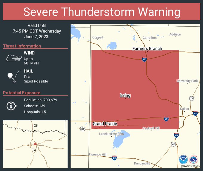
Now Irving getting in on the action
1 likes
Winter time post are almost exclusively focused on the DFW area.
Re: Texas Summer 2023
bubba hotep wrote:Now Irving getting in on the action
https://pbs.twimg.com/media/FyD06ioacAA_prp?format=jpg&name=small
Irving definitely in on the action. Nice storm that cooled things off real quick. Good thunder and lightning.
5 likes
-
Brent
- S2K Supporter
- Posts: 37086
- Age: 35
- Joined: Sun May 16, 2004 10:30 pm
- Location: Tulsa Oklahoma
- Contact:
Re: Texas Summer 2023
Had a random downpour here earlier... I'm gonna miss this in a couple weeks. Possibly a run at triple digits next weekend... Yay so excited 
1 likes
#neversummer
-
cheezyWXguy

- Category 5

- Posts: 5528
- Joined: Mon Feb 13, 2006 12:29 am
- Location: Dallas, TX
Re: Texas Summer 2023
Saturday has been highlighted as a severe weather risk since yesterday for central Texas up to Oklahoma and points east. Doesn’t look like a big tornado threat, but hail and winds appear to be on the menu
4 likes
-
jasons2k

- Storm2k Executive

- Posts: 8071
- Age: 50
- Joined: Wed Jul 06, 2005 12:32 pm
- Location: The Woodlands, TX
Re: Texas Summer 2023
Update for SE Texas from Jeff Lindner:
A chance of strong to severe thunderstorms this afternoon over the region.
An upper level disturbance within the northwest flow on the outer edge of a building ridge of high pressure over northern Mexico will move across SE TX this afternoon and evening. Given surface heating and temperatures rising into the low 90’s by mid afternoon combined with lift from the approaching disturbance and decent moisture, clusters of showers and thunderstorms are likely to develop. Profiles support a strong/damaging wind threat with some of these storms depending on how organized they become. Cluster/line of storms will likely develop in the College Station to San Antonio corridor by mid afternoon and track SE toward the coast into the evening hours. Where this activity encounters the inland moving Seabreeze front some enhancement of storms will be possible. SPC has portions of the area in a 2 out of 5 risk level for damaging winds this afternoon and evening.
Ridge attempts to build into the area this weekend, but another disturbance in the NW flow looks to clip the area on Saturday and again may result or enhance some thunderstorms activity.
There after…high pressure become established into next week with gradually increasing high temperatures and heat index values…guidance progs heat index values near advisory criteria by next Thursday and Friday.
Tropics:
Nothing of interest in the Atlantic basin through the next 7 days. GFS continues to forecast a hurricane from the western Caribbean into the Gulf of Mexico the week of the 19th…it is the only model that is showing this (CMC and ECWMF do not show anything of significance in the western Caribbean during this period). I certainly question if the GFS has the correct upper air pattern in place since both the CMC and ECMWF have 30-40kts of wind shear over the western Caribbean Sea during this period. I normally would not mention such “long range” model speculation…but there are questions…simply put… I do not believe the GFS and this model has a tendency of developing western Caribbean tropical systems that never happen.
Severe Weather Outlook (This afternoon/Evening):
1 likes
Re: Texas Summer 2023
Looks like we are going to end up with a strong El Nino this year. It's been an odd evolution that has started slow but is increasing in intensity.
Spring rainfall has been mixed with some benefiting and some not. At some point though, the El Nino will be a huge driver. One of the coming seasons (Summer, Fall, Winter) will experience exceptional rainfall most likely. The PDO has been a block, but 2009 had a very wet Fall despite cold PDO-esque Nino.
Spring rainfall has been mixed with some benefiting and some not. At some point though, the El Nino will be a huge driver. One of the coming seasons (Summer, Fall, Winter) will experience exceptional rainfall most likely. The PDO has been a block, but 2009 had a very wet Fall despite cold PDO-esque Nino.
6 likes
The above post and any post by Ntxw is NOT an official forecast and should not be used as such. It is just the opinion of the poster and may or may not be backed by sound meteorological data. It is NOT endorsed by any professional institution including Storm2k. For official information, please refer to NWS products.
Help support Storm2K!
-
ElectricStorm

- Category 5
- Posts: 4523
- Age: 23
- Joined: Tue Aug 13, 2019 11:23 pm
- Location: Skiatook, OK / Norman, OK
Re: Texas Summer 2023
Morning convection will probably ruin most of the severe threat for a good chunk of OK Saturday but down in TX could be more concerning. Could be an active pattern over the next week or so for June at least.
0 likes
I am in no way a professional. Take what I say with a grain of salt as I could be totally wrong. Please refer to the NHC, NWS, or SPC for official information.
Boomer Sooner!
Boomer Sooner!
-
Edwards Limestone

- S2K Supporter
- Posts: 335
- Age: 34
- Joined: Tue Dec 28, 2021 11:05 am
- Location: Smithson Valley, TX
Re: Texas Summer 2023
https://twitter.com/NWSSanAntonio/status/1666879612805353472
https://twitter.com/ChikageWeather/status/1666885634672427008
https://twitter.com/ChikageWeather/status/1666885634672427008
2 likes
The above post is NOT an official forecast and should not be used as such. It is just the opinion of the poster and may or may not be backed by sound meteorological data. It is NOT endorsed by any professional institution including Storm2k. For official information, please refer to NWS products.
-
South Texas Storms

- Professional-Met

- Posts: 4002
- Joined: Thu Jun 24, 2010 12:28 am
- Location: Houston, TX
Re: Texas Summer 2023
I'm tired of these big storms that keep causing damage and knocking out my power for hours in northwest Houston. Today's produced 60-70 mph winds and took out a big chunk of my tree in the front yard. Power has been out since 5:30pm.
2 likes
-
ElectricStorm
- Category 5
- Posts: 4523
- Age: 23
- Joined: Tue Aug 13, 2019 11:23 pm
- Location: Skiatook, OK / Norman, OK
Re: Texas Summer 2023
Enhanced risk is up for Saturday including DFW
1 likes
I am in no way a professional. Take what I say with a grain of salt as I could be totally wrong. Please refer to the NHC, NWS, or SPC for official information.
Boomer Sooner!
Boomer Sooner!
-
cheezyWXguy
- Category 5
- Posts: 5528
- Joined: Mon Feb 13, 2006 12:29 am
- Location: Dallas, TX
Re: Texas Summer 2023
ElectricStorm wrote:Enhanced risk is up for Saturday including DFW
https://i.imgur.com/u0EjJXn.gif
This event looks conditional for north Texas again, dependent on the track of an overnight mcs that should track across southern Oklahoma. If it manages to make it to the i20 corridor in the morning, I expect the risk area to shift significantly south (HRRR). However, if it dissipates or the area receives a glancing blow (NAM), the full risk would still be realized.
0 likes
-
rwfromkansas
- Category 5
- Posts: 2160
- Joined: Sat Aug 27, 2005 12:47 am
- Location: North Fort Worth
Re: Texas Summer 2023
Looks like it is going to be awful hot for awhile. Ugh.
Side note: is this air quality alert expansion new? It used to be only used for big city areas like Houston or DFW.
Now most of eastern NE is under that for ozone, so not wildfires. Even parts of north OK with nobody living there.
It’s hard to take these ridiculous “alerts” serious when they are now issuing them when there is no legitimate air quality problem.
0 likes
Re: Texas Summer 2023
rwfromkansas wrote:Looks like it is going to be awful hot for awhile. Ugh.
Side note: is this air quality alert expansion new? It used to be only used for big city areas like Houston or DFW.
Now most of eastern NE is under that for ozone, so not wildfires. Even parts of north OK with nobody living there.
It’s hard to take these ridiculous “alerts” serious when they are now issuing them when there is no legitimate air quality problem.
There is actually smoke particles across a lot of the US east of the Rockies. NE Oklahoma is within the area where there are elevated amounts. Now the criteria might be different for different areas, not sure on that one. It isn't just northeast Canada that has been on fire, so has western and central Canada. The east has been getting the most news coverage due to the big name cities but it covers a much larger area.
Milky low level smoke can be seen down the eastern Great Plains and throughout east of the MS.

1 likes
The above post and any post by Ntxw is NOT an official forecast and should not be used as such. It is just the opinion of the poster and may or may not be backed by sound meteorological data. It is NOT endorsed by any professional institution including Storm2k. For official information, please refer to NWS products.
Help support Storm2K!
Help support Storm2K!

Re: Texas Summer 2023
HOT OFF THE GFS PRESS - CAT 5 IN THE GULF!!!!!!
I mean, it's only 360 hours out, what can go wrong?

I mean, it's only 360 hours out, what can go wrong?
5 likes
The above post and any post by dhweather is NOT an official forecast and should not be used as such. It is just the opinion of the poster and may or may not be backed by sound meteorological data. It is NOT endorsed by any professional institution including storm2k.org. For official information, please refer to NWS products.
-
rwfromkansas
- Category 5
- Posts: 2160
- Joined: Sat Aug 27, 2005 12:47 am
- Location: North Fort Worth
Re: Texas Summer 2023
Well oops. Nevermind. Thanks for the info. When I read the alert I thought they meant pollution.
Those Canadian fires have to be historic.
Those Canadian fires have to be historic.
0 likes
-
vbhoutex

- Storm2k Executive
- Posts: 28972
- Age: 72
- Joined: Wed Oct 09, 2002 11:31 pm
- Location: Spring Branch area, Houston, TX
- Contact:
Re: Texas Summer 2023
From Jeff Lindner at Harris County Flood Control:
Severe Thunderstorms will be possible Saturday afternoon and evening over portions of SE TX.
While high pressure is starting to build northward out of Mexico, a strong upper level disturbance will move around the northern and eastern sides of the building upper level high over portions of north and east Texas. A few days ago it appeared that the upper level ridge would have built into SE TX by this Saturday and guided any activity to our north and east, but the building high has been slower to evolve and this will allow the potential for this disturbance and it’s associated activity to move close or across SE TX on Saturday.
A large thunderstorm complex is likely across western Texas tonight associated with this disturbance and this activity will eventually weaken early Saturday morning across portions of west-central Texas. With surface heating and the approach of the upper level disturbance, scattered showers and thunderstorms will develop and move into and across the area, especially areas along and north of I-10. Current thinking is that areas across the northern and central portions of the area and into the eastern portions of the area will have the highest risk of storms and severe weather given the further extend away from higher heights over southern Texas.
Air mass will once again become very unstable Saturday afternoon and forecast profiles are favorable for strong damaging winds similar to Thursday afternoon where wind damage and gusts up to 70mph occurred over the area. SPC has much of the area north of I-10 in a level 2 out of 5 severe weather threat on Saturday afternoon. Storms will move from northwest to southeast across the region…again favoring areas mainly northeast of a line from College Station to Sealy to Freeport.
Next Week:
Ridge builds northward after Saturday and a stretch of hot weather is in store for the region with highs into the mid 90’s and then upper 90’s next week. Toward the end of next week, highs could approach 100 away from the coast. Heat index values starting Wednesday and beyond will likely reach into the 106-109 degree range which may require heat advisories for portions of the area. Rain chances will fall to near zero after Saturday with strong subsidence in place.
0 likes
Skywarn, C.E.R.T.
Please click below to donate to STORM2K to help with the expenses of keeping the site going:

Please click below to donate to STORM2K to help with the expenses of keeping the site going:
-
bubba hotep
- S2K Supporter
- Posts: 5453
- Joined: Wed Dec 28, 2016 1:00 am
- Location: Collin County Texas
Re: Texas Summer 2023
Models have shifted the overnight MCS well east of DFW and really struggle to fire anything in the afternoon. I would roll the ENH back to Slight just based on lack of coverage.
1 likes
Winter time post are almost exclusively focused on the DFW area.
Return to “USA & Caribbean Weather”
Who is online
Users browsing this forum: No registered users and 48 guests