Page 1 of 79
Texas Spring 2025
Posted: Tue Jan 28, 2025 11:04 am
by Texas Snowman
Re: Texas Spring 2025
Posted: Wed Jan 29, 2025 8:37 am
by wxman57
Ah, thank you, Mr. Snowman! The arrival of February always brings hope to my heart (of warmth). I've only been out on my bike once this month due to the cold and rain. Time for some riding Friday.
Re: Texas Spring 2025
Posted: Mon Feb 10, 2025 8:30 am
by HockeyTx82
So are we transitioning to here now?

Re: Texas Spring 2025
Posted: Wed Feb 19, 2025 11:30 pm
by gpsnowman
March Madness incoming?? Let's hope so and continue winter for a while!!!

Re: Texas Spring 2025
Posted: Tue Feb 25, 2025 8:15 am
by snownado
Obviously the timing for this thread being created was way off, but it does appear we're now finally beginning the step-up into Spring/Summer temps.
And yes, next week is *POTENTIALLY* looking active severe weather-wise...
Re: Texas Spring 2025
Posted: Wed Feb 26, 2025 12:31 pm
by wxman57
Speaking of bicycles, 70s and 80s are much better for getting outdoors than 40 degrees and raining. I've come up from my underground bunker and peeked my head outside. Yep, winter is gone! We'll get another 4-5 weak cold fronts over the next month, but nothing like recent cold weather.
MAWA!
Re: Texas Spring 2025
Posted: Thu Feb 27, 2025 9:22 pm
by ElectricStorm
https://m.youtube.com/watch?v=-qszQpZcj ... JvbmljbGVz2025 spring tornado forecast video from Convective Chronicles. Very good info as always. Looking at his analog years, it appears the southern plains may be in for a quieter season, especially during May.
Re: Texas Spring 2025
Posted: Fri Feb 28, 2025 1:41 pm
by Edwards Limestone
Headed for disaster
Re: Texas Spring 2025
Posted: Fri Feb 28, 2025 6:21 pm
by TomballEd
Tuesday may be significant for severe weather for much of East Texas, as far W as DFW and as far S as the NE Houston suburbs.
I'm limited on posting images at work. imgur and the such are blocked.
Re: Texas Spring 2025
Posted: Fri Feb 28, 2025 6:58 pm
by TomballEd
NWS HGX
An active/stormy weather pattern looks to set up on Tuesday, with
the potential for strong to severe storms, as a healthy mid to upper
level trough moves across the Southern Plains late Monday into
Tuesday and an associated cold front pushes across our local area
during the day. Although it`s a little early to know exact timing of
the front, an approximate timeframe could be the front near or
across the Brazos Valley and Piney Woods region around sunrise and
pushing off the coast sometime during the afternoon hours. As far as
timing the showers and thunderstorms, we could start to see rain
showers over the Brazos Valley and Piney Woods starting around
midnight and continuing overnight. As we near daybreak, the
development of showers and thunderstorms will increase and expand
southward as the front progresses into Southeast Texas. During that
time, we may still have the influence of a 30-40kt low level jet
along with a strong upper level jet. Moisture convergence will also
bring up our surface PWs to around 1.5 inches just ahead of the
front. In addition, we could see some vort maxes pass overhead which
will enhance shower and storm development. Thus, we could see some
locally heavy rain for some folks along with the chance for strong
storms. Now, although the probability for strong to severe storms
has ebbed slightly since yesterday and is shifted a little more to
our northeast, there is still the possibility for severe weather
to develop. SPC Severe Weather Outlook still outlines areas north
of I-10 for the potential of severe storms. Please stay tuned for
additional forecast updates and be prepared for an active weather
day on Tuesday.
FWD
In the wake of the departing upper low, a stouter mid-level
system will zip through the Central Plains Monday into Tuesday. As
the low moves closer, increased forcing for ascent will spread
across North and Central Texas. By Monday evening, warm advection
induced showers will start up across portions North Texas and the
Big Country out ahead of the dryline. Eventually, the
dryline will advance east across North and Central Texas and
become a focusing point for additional storm development overnight
through the first half of Tuesday. As the dryline moves east,
storms will grow upscale into more of a linear storm mode.
Environmental soundings show MUCAPE ~ 1000 J/kg, SBCAPE between
500-1000 J/kg, mid-level lapse rates ~ 7 C/km, and deep layer
shear at 40 kts or greater. All of this said, some storms
overnight into Tuesday afternoon could become strong to severe,
with large hail and damaging winds continuing to be the main
threats. The severe threat will mainly be confined to areas near
and east of I-35. The progressive nature of the system will keep
rainfall totals generally around 1" or less, with the highest
totals expected east of I-35.
Re: Texas Spring 2025
Posted: Sat Mar 01, 2025 4:30 am
by HockeyTx82
Hello Spring!

Re: Texas Spring 2025
Posted: Sat Mar 01, 2025 11:03 am
by wxman22
Looks like there may be a weak squall line here tomorrow. Nice as the rain is needed.


Re: Texas Spring 2025
Posted: Sat Mar 01, 2025 11:30 am
by gpsnowman
A couple of our locals just this morning showed that complex in Oklahoma. Let's hope it can extend down south a bit.
Re: Texas Spring 2025
Posted: Sat Mar 01, 2025 12:05 pm
by snownado
gpsnowman wrote:A couple of our locals just this morning showed that complex in Oklahoma. Let's hope it can extend down south a bit.
HRRR is definitely an outlier with the southern extent of coverage.
Re: Texas Spring 2025
Posted: Sat Mar 01, 2025 5:59 pm
by snownado
Tenps overachieved a few degrees today, with an intra-hour high of 80*F at DFW.
Re: Texas Spring 2025
Posted: Sun Mar 02, 2025 9:02 am
by wxman22
The first severe weather risk locally of the season.


Re: Texas Spring 2025
Posted: Sun Mar 02, 2025 9:11 am
by wxman22
Re: Texas Spring 2025
Posted: Sun Mar 02, 2025 12:30 pm
by Ntxw
Would up ULL for a couple of storm chances, then windy. Probably will expand wind advisories/warnings for the northern half of the state in OK tues on forward.
Re: Texas Spring 2025
Posted: Sun Mar 02, 2025 12:52 pm
by wxman22

Day 2 Convective Outlook
NWS Storm Prediction Center Norman OK
1130 AM CST Sun Mar 02 2025
Valid 031200Z - 041200Z
...THERE IS A SLIGHT RISK OF SEVERE THUNDERSTORMS FOR PARTS OF
CENTRAL/EASTERN OKLAHOMA INTO NORTH TEXAS...
...SUMMARY...
A rapidly developing line of thunderstorms will bring the potential
for damaging winds, a few tornadoes, and isolated large hail for
parts of the southern Plains Monday night.
...Synopsis...
Shortwave, upper-level ridging across the southern Plains will give
way to a strong upper trough progressing eastward through the
Southwest on Monday. The strongest mid-level height falls are
expected to occur during the late evening/overnight period into
Tuesday morning. As this trough approaches, a central High Plains
surface low will deepen and evolve southeastward with time. A
Pacific front will be the focus for thunderstorm development from
central/eastern Kansas into the Hill Country/Central Texas.
...Oklahoma/Texas...
A line of thunderstorms is expected to develop along the Pacific
front late Monday night as strong mid-level ascent overspreads the
region. The highly amplified/meridional mid/upper-level winds will
promote a rapid transition to a linear storm mode. Strong deep-layer
shear and steep mid-level lapse rates could lead to briefly higher
potential for large hail from initial supercells, but the strong
signal for a linear storm mode would suggest large hail will likely
remain isolated. Strong low-level wind fields are expected along and
ahead of this line of activity. With at least low 60s F dewpoints
expected in parts central/eastern Oklahoma into North/Central Texas,
storms will be near-surface based to surface based and capable of
damaging wind gusts. Low-level hodographs will also be enlarged
across the warm sector. The exact magnitude of the tornado threat is
a bit uncertain given the linear storm mode as well as marginal
low-level instability during the overnight. However, the strength of
the low-level shear will be sufficient to at least conditionally
support a few QLCS tornadoes. The eastern extent of the threat will
be limited by decreasing buoyancy into far eastern
Oklahoma/Arkansas. The southern edge of the activity also is not
clear. However, storms on the southern flank may have a greater
potential to produce large hail. Confidence in the location of this
activity is too low to increase hail probabilities at this time.
Re: Texas Spring 2025
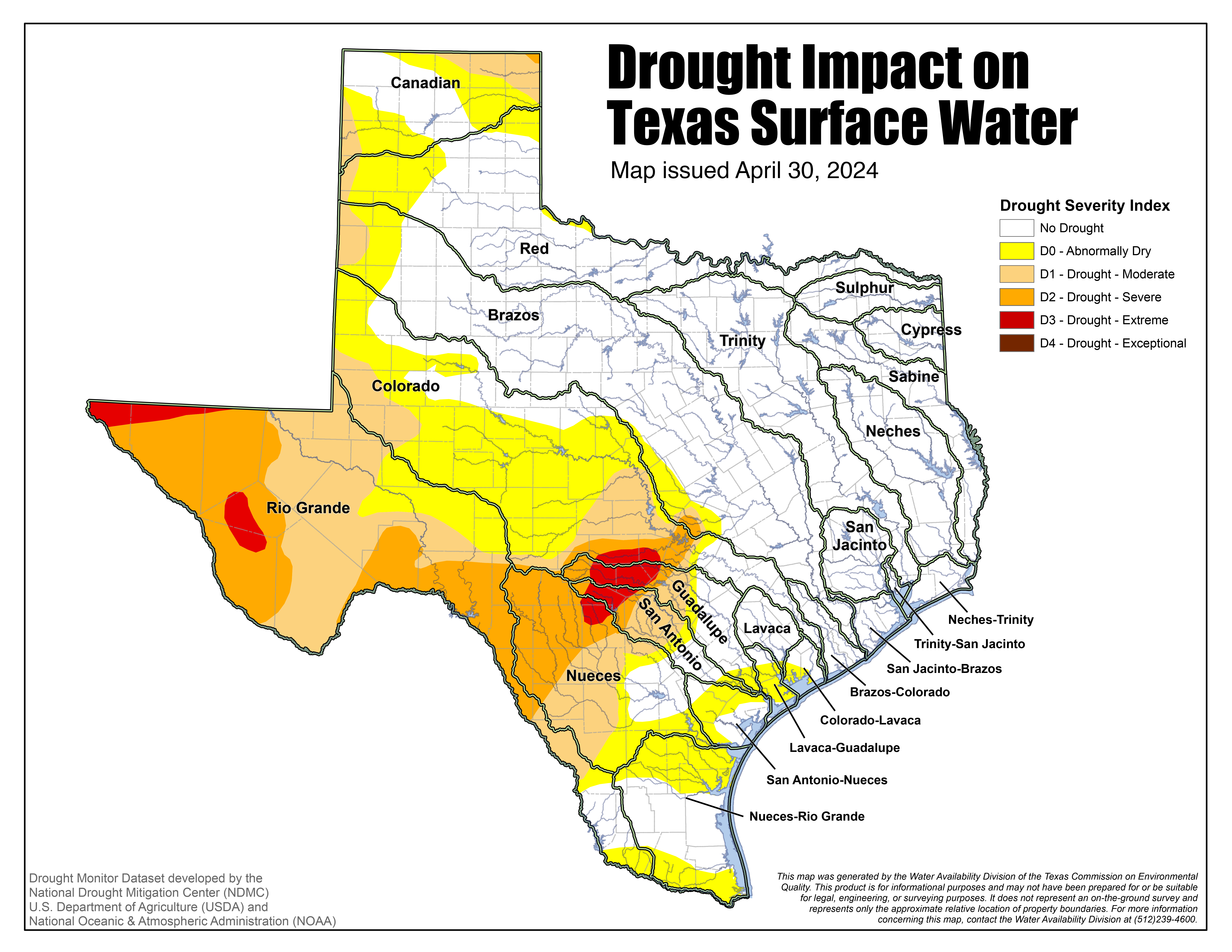
Posted: Sun Mar 02, 2025 1:49 pm
by South Texas Storms
Very depressing weather pattern looks to be setting up over the next few weeks. The parts of TX in the worst drought will likely miss out on any meaningful rainfall...while areas that aren't in drought appear to get several rounds. Even worse, south and west TX will see critical fire weather conditions due to the strong winds, dry air, and extreme drought. I really hope the pattern changes later this month or else this summer could be horrific.


