Page 1 of 16
2025 Severe Weather in U.S
Posted: Sat Feb 15, 2025 12:24 pm
by cycloneye
Decided to make the 2025 severe season thread as things may begin early and it may be an active one. We will see how it unfolds.
 https://www.spc.noaa.gov/wcm/ https://x.com/webberweather/status/1890803385089057236
Here is Eric Webb's text of message.
Wrt the upcoming tornado season, it's honestly a little troubling how close both the low frequency ocean *and* atmosphere base states are this year to 2011, minus the fact that we have a much warmer Gulf this time around (yikes).
The deep-layer zonal wind/atmospheric angular momentum distribution mid-late winter this year & of course the global SSTs are honestly about as close as it gets.
Re: 2025 Severe Weather
Posted: Sat Feb 15, 2025 4:35 pm
by cycloneye
Re: 2025 Severe Weather
Posted: Sat Feb 15, 2025 5:20 pm
by cycloneye
Re: 2025 Severe Weather
Posted: Sat Feb 15, 2025 7:47 pm
by cycloneye
Re: 2025 Severe Weather
Posted: Sun Feb 16, 2025 12:36 pm
by cycloneye
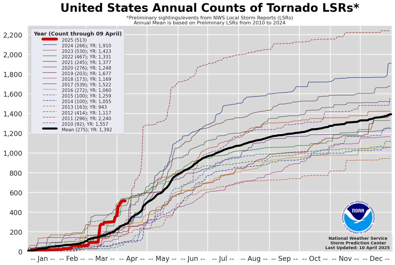
The score so far in 2025 is 33 tornadoes and that is below the average of 76 as of Febuary 15. See the graphic that updates every day at first post. Hopefully it stays below average all year but I fear will be an active season as Webb points out.
Re: 2025 Severe Weather
Posted: Sun Feb 16, 2025 12:56 pm
by cycloneye
This is very interesting from Webb about location of most of activity and possible analog years.
These are Mr Webb's analogs.

Here is the message from first tweet.
I came up w/ list of analogs for this year's tornado season & this is what the 1°x1° tornado track density composite grid looks like over the CONUS using
@NWSSPC database that goes back to 1950.
Note I used a 30-year sliding base period anomaly here to account for long-term non-stationary behavior in tornado data (due to better detection & increased spotting in recent years).
Although tornadoes will still certainly occur over the Great Plains, this analog composite is highlighting an *anomalous* eastward shift in tornado activity this year, with the epicenter of anomalously positive tornado activity closer to the mid-Mississippi Valley.
https://x.com/webberweather/status/1891184325779149235
From second tweet:
What really catches my eye w/ this anomaly composite is how closely it resembles the long-term trends in favorable tornado environments (left figure from
@gensiniwx
& Brooks (2018)).
This suggests that this year may reinforce some of the long-term observed trends in tornado activity over the CONUS. From third tweet:
Fwiw, here's what the 2-week total tornado count looks like in this subset of years vs climatology.
Notice the peculiar "double" peak in activity near the peak of the season w/ one peak in late April into early May & another near the end of May.
This "double" peak in tornado activity actually also shows up in the 30-year mean climo data too, as far back as the 1960s & 70s, as well as the SPC watch counts https://x.com/webberweather/status/1891185235381088324
https://x.com/webberweather/status/1891187396437574090
Re: 2025 Severe Weather
Posted: Fri Feb 21, 2025 6:38 pm
by cycloneye
Below is the part of Webb's message about severe weather.
-NAO regimes also usually precede periods with big tornado outbreak potential in the spring by about 2 weeks & this year's low frequency base state is very conducive to that. https://x.com/webberweather/status/1893052024369094664
Re: 2025 Severe Weather
Posted: Sat Feb 22, 2025 3:52 pm
by cycloneye
Re: 2025 Severe Weather
Posted: Mon Feb 24, 2025 7:47 pm
by cycloneye
History made today in South Dakota as the first tornado ever in febuary occured on that state.
https://x.com/weathertrackus/status/1894151394996736004
Re: 2025 Severe Weather
Posted: Mon Feb 24, 2025 8:41 pm
by cycloneye
In Oregon also a first tornado warning in Febuary.
https://x.com/VortixWx/status/1894199043712074098
Re: 2025 Severe Weather
Posted: Tue Feb 25, 2025 10:58 am
by cycloneye
Re: 2025 Severe Weather
Posted: Wed Feb 26, 2025 5:34 am
by cycloneye
15% for day 7.

Re: 2025 Severe Weather
Posted: Wed Feb 26, 2025 9:16 am
by cycloneye
Re: 2025 Severe Weather
Posted: Wed Feb 26, 2025 10:18 pm
by cycloneye
Re: 2025 Severe Weather
Posted: Thu Feb 27, 2025 5:48 am
by cycloneye
Re: 2025 Severe Weather
Posted: Thu Feb 27, 2025 11:40 am
by cycloneye
Re: 2025 Severe Weather
Posted: Thu Feb 27, 2025 1:38 pm
by cycloneye
Re: 2025 Severe Weather
Posted: Fri Feb 28, 2025 11:02 am
by cycloneye
Day 5.

Re: 2025 Severe Weather
Posted: Sat Mar 01, 2025 7:54 am
by cycloneye
Re: 2025 Severe Weather
Posted: Sun Mar 02, 2025 7:19 am
by cycloneye

Day 3 Convective Outlook
NWS Storm Prediction Center Norman OK
0224 AM CST Sun Mar 02 2025
Valid 041200Z - 051200Z
...THERE IS AN ENHANCED RISK OF SEVERE THUNDERSTORMS TUESDAY
AFTERNOON AND EVENING ACROSS SOUTHERN ARKANSAS....MUCH OF NORTHERN
AND CENTRAL LOUISIANA AND CENTRAL/SOUTHERN MISSISSIPPI...
...SUMMARY...
One or two organized lines or clusters of thunderstorm, and perhaps
a few supercells, will pose a risk for damaging wind gusts, a few
tornadoes and hail, primarily across parts of the lower Mississippi
Valley into Southeast, Tuesday through Tuesday night.
...Discussion...
Latest model output remains a bit varied concerning the evolution
and motion of a significant mid/upper trough, which is generally
forecast to be in the process of shifting across and east of the
southern Rockies Monday night into early Tuesday. However, guidance
indicates that it will remain progressive, and likely to overspread
much of the Mississippi Valley by the end of the period. In
lower-levels a broad deep cyclone is likely to continue to evolve,
with the center forecast to track from Kansas into the Upper Midwest
by 12Z Wednesday.
In the wake of a recent intrusion of dry/potentially cool air,
associated with surface ridging shifting east of the Atlantic
Seaboard, models indicate that an influx of moisture off the western
Gulf Basin will advect eastward ahead of the cold front trailing the
cyclone. However, northeast of the southeastern Great Plains into
lower Mississippi Valley, the moisture return may remain elevated
above a residual cool/stable near surface layer. Still, large-scale
forcing for ascent and destabilization will probably be sufficient
to support extensive thunderstorm development across the interior
U.S., and a fairly broad area with at least a conditional risk for
severe storms, given the strength of flow/shear in the evolving warm
sector.
...Lower Mississippi Valley into Southeast...
An initially well-defined near-surface baroclinic zone may extend
from the Arkansas/Oklahoma vicinity southeastward through the lower
Mississippi Valley at the outset of the period. While it appears
that this boundary may become more diffuse while shifting eastward
during the day, it may still provide the primary focus for an
organizing cluster and/or discrete supercell development, as forcing
for ascent associated with a short wave perturbation within the
larger-scale mid/upper troughing overspreads the region.
Of concern, models indicate that this feature will be accompanied by
an intense jet core, which may include south-southwesterly winds of
70-100 kt in the 850-500 mb layer overspreading portions of
Louisiana and Mississippi. These speeds appear generally forecast
within the inflow layer of potential storm development, with speeds
tending to weaken to 40-50 kt as they veer to a more westerly
component in the potential downdraft source region. So uncertainty
exists concerning the magnitude of potential downward mixing of
momentum in convective development.
Even so, particularly along the remnant boundary, the environment
probably will become conducive to potential for damaging wind gusts,
a few tornadoes and some hail across southern Arkansas and northern/
central Louisiana into Mississippi. As this activity spreads
eastward Tuesday night, the extent to which near-surface
thermodynamic profiles support a risk for damaging surface gusts and
tornadoes across Alabama into Georgia remains unclear, but it seems
likely to diminish with eastward extent and time.
..Kerr.. 03/02/2025
