gravity wave?
Posted: Wed Feb 25, 2004 9:19 pm
by timNms
Posted: Thu Feb 26, 2004 12:29 pm
by MWatkins
Think of a gravity wave..in a 3d atmospheric sense...as a ripple in the atmosphere...not unlike the waves resulting from dropping a rock in a pond. Thunderstorm outflow boundaries can cause gravity waves for example...they are also though to occur on the lee side of mountian ranges.
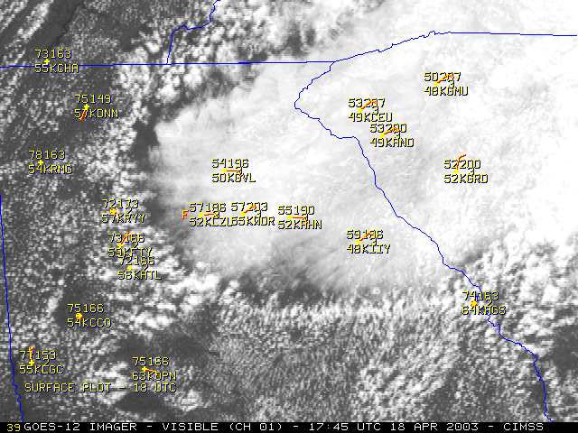
Here's a cool image of one over Georgia from April 2003:
http://cimss.ssec.wisc.edu/goes/misc/03 ... OBS_20.GIF
Here's another example in the gulf of Mexico:
http://cimss.ssec.wisc.edu/goes/misc/gravity_wave.html
A gravity wave is thought to have been a key player in the development of the huge Jarrell Texas tornado back in 1997:
http://www.spc.noaa.gov/publications/co ... arrell.htm
http://www.srh.noaa.gov/ssd/techmemo/sr198.htm
Here's a good overview of how gravity waves are dectected/forecast by the NWS:
http://www.erh.noaa.gov/er/akq/GWave.htm
Here's another more technical discussion:
http://hugo.atmos.colostate.edu/tutorial.html
Hope this helps.
MW
Posted: Thu Feb 26, 2004 12:33 pm
by timNms
Thanks Mike. That helped a lot! I don't recall hearing about gravity waves before and when I saw it on the NWS site, I was clueless.
Posted: Thu Feb 26, 2004 6:52 pm
by Stormsfury
timNms wrote:Thanks Mike. That helped a lot! I don't recall hearing about gravity waves before and when I saw it on the NWS site, I was clueless.
One more event for you to absorb from the GSP region on Dec 13th, 2002.
http://www.stormsfury1.com/Weather/GravityWave.html
Posted: Thu Feb 26, 2004 10:24 pm
by Erica
In order to get a gravity wave to form, the synoptic setup has to be favorable.
For example, the synoptic features favoring gravity wave formation include a large scale diffluent flow between the 300mb trough axis and ridge Axis, a strong upper level jet maximum moving away from the trough in the direction of the downstream ridge, apart from the geostrophic speed maximum moving into the vicinity of the inflection axis.
Also, because the movement of the speed maximum downstream from the geostrophic wind maximum rounding the base of the trough leads to the development of a divergent ageostrophic flow, in a relatively unbalenced state, the result is the reverse of the quasi-grostrophic theory. The flow is then pushed in the direction of the lower heights, at the mouth of the geostrophic speed maximum.
A clearly defined surface warm frontal boundary must also be present to the south of the area favored for gravity wave formation.
The relationship between gravity waves and convective processes are much more important. This is where the wave CISK (Conditional Instability of the Second Kind) comes into play, where organized areas of convection are acted on by convergence associated with a gravity wave, and the energy source for the wave is acquired through latent heat release. The result is that the convection causes the amplification of the wave trough and ridge through compensation of subsidence and evaporative cooling processes. And, the strongest UVM associated with the convection when considering the wave CSIK theory has to be present in relationship to the wave, in the wave critical level, and cannot be coinciding with the stable layer, once this is acheived, the gravity wave and Convective processes will work as a unit.
Gravity wave detection is very important as in the past when less was understood about this phenomena It has lead to major forecast errors, and incorrect interpretation of model information, I.E. unnecessary corrections to the models as the result of the gravity wave, or the appearence of secondary coastal cyclogenesis due to rapid pressure falls associated with a gravity wave.
How to diagnose gravity waves? This is probably the more simple part (at least in my opinion), so far there are four effective ways to do so.
First, using the aforementioned forecasting techniques discussed previously to determine if the synoptic environment is favorable for the development of gravity waves.
Second, model diagnostics to see whether or not the flow is unbalenced, or if wave ducting is present. (Mathematically invloved, so I will refrain from any further discussion of that topic since it's very invloved and wouldin't be beneficial to others which are not experienced with it, unless someone would like me to discuss it)
Third, use of the automated ASOS gravity wave detection system.
Lastly, use of Satellite and Radar images to assess the observed cloud pattern becasue the wave can alter it. But if the two are moving in tandem with one another, there may be little effect on the cloud pattern, making the wave harder to detect.
Also keep an eye on any unusual changes in convective processes or elements, bands, and changes in cloud structure according what's talked above above.
Since gravity waves are mesoscale features, much like CSI, they can't be predicted correctly by the models. This is why the understanding of the synoptic pattern, and use of the diagnostic tecniques are so important. As they are with CSI, eventhough the two aren't directly related.
Posted: Thu Feb 26, 2004 11:09 pm
by MWatkins
In the era of hi-res satellite these things are a lot eaiser to pick up. I remember reading that gravity waves are present with winter-time convective systems as much as 37% of the time.
I'm facsinated with the role of a MCC created g-wave and it's effect on the Jarrel tornado. Thank goodness that's one of those things that happens only once every 75 years or so.
MW