Severe wx possible FLA today-Tues >1 event psbl

U.S. & Caribbean Weather Discussions and Severe Weather Events

Moderator: S2k Moderators

Forum rules

The posts in this forum are NOT official forecast and should not be used as such. They are just the opinion of the poster and may or may not be backed by sound meteorological data. They are NOT endorsed by any professional institution or STORM2K.

Help Support Storm2K
Message
Author
Anonymous

Severe wx possible FLA today-Tues >1 event psbl

#1 Postby Anonymous » Sun Apr 11, 2004 3:23 am

Looks like we may see more than one round of severe wx here beginning this afternoon as seabreeze induced storms develop with temps in the upper 80s and then the springtime frontal system approaches and enhances activity overnite sunday through the day Monday maybe into Tuesday...

NWS Jax disc

Code: Select all

...SEVERE WX POSSIBLE FROM LATE THIS AFTERNOON THROUGH MONDAY
NIGHT...

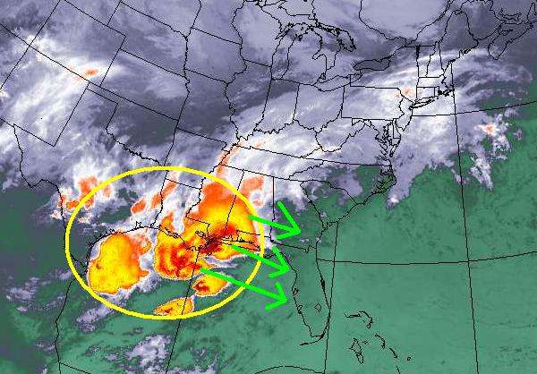
.SHORT TERM...CURRENTLY VERY QUIET ACROSS THE AREA WITH FRONTAL
BOUNDARY TO THE NORTH AND WEAK PRESSURE PATTERN IN PLACE. A LITTLE
LIGHT FOG DEVELOPING BUT NOTHING DENSE AS OF YET. CONDITIONS BEGIN
TO CHANGE RAPIDLY BY THIS AFTERNOON AS POTENT SPRING STORM TAKES
SHAPE ACROSS THE LOWER MISSISSIPPI VALLEY. SOUTHERLY FLOW AHEAD OF
THIS SYSTEM WILL ONCE AGAIN ALLOW TEMPERATURES TO RISE WELL INTO
THE 80S THIS AFTERNOON. EXPECT GOOD SEABREEZE DEVELOPMENT THIS
AFTERNOON WITH COLLISION POSSIBLE ALONG THE EAST COAST BY LATE
AFTERNOON. MODEL SOUNDINGS DEPICTING DECENT INSTABILITY AND
INCREASING MID LEVEL SOUTHWEST FLOW THIS PM SO SOME SEABREEZE
INDUCED STORMS ARE POSSIBLE...WITH A POSSIBILITY FOR SOMETHING
STRONG TO DEVELOP AS NOTED IN SPC DAY 1 OUTLOOK.

NEXT ROUND OF HEAVIER RAIN EXPECTED LATE SUNDAY NIGHT INTO MONDAY
MORNING AS LEAD SHORTWAVE MOVES NORTHEAST ACROSS THE AREA. BIG
QUESTION IS POTENTIAL FOR SEVERE STORMS. AM DISCOUNTING GFS AND IS
65KT H85 JET AND LEANING TOWARDS ETA SOLUTION...WHICH IS WEAKER BUT
STILL HOLDS THE POTENTIAL FOR STRONG TO SEVERE STORMS. AS FIRST
SHORT WAVE EXITS...WX ACROSS THE AREA EXPECTED TO REMAIN UNSETTLED
DURING THE DAY MONDAY WITH MOIST SOUTHWEST FLOW CONTINUING AND
ATMOSPHERE FAIRLY UNSTABLE EXPECT SCATTERED TSTORMS THROUGHOUT THE
DAY.

ANOTHER SHORTWAVE ROUNDS THE BASE OF THE TROUGH MONDAY NIGHT INTO
TUESDAY MORNING WITH DIVERGENCE ALOFT INCREASING AND LOW-LEVEL JET
STRENGTHENING ONCE AGAIN. POSSIBILITY OF SEVERE WX EXISTS WITH THIS
IMPULSE AS WELL.

MODELS CONTINUE TO TREND SLOWER WITH THE UPPER TROUGH AXIS MOVING
EAST WITH SOME SHOWER AND STORM ACTIVITY POSSIBLE AGAIN ON TUESDAY
BEFORE PASSAGE OF THE WAVE AXIS SHUTS THINGS DOWN.


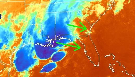
SPC day 3 outlook (tues)

Code: Select all

...SERN GA ACROSS FL...
   SEVERE THUNDERSTORM THREAT OVER THIS AREA WILL LIKELY BE EARLY IN
   THE PERIOD AS SQUALL LINE OR BROKEN LINE OF STRONG TO SEVERE
   THUNDERSTORMS WILL BE ONGOING AND SHIFT ESEWD THROUGH THE DAY.
   STRONG WSWLY FLOW ALOFT WILL MAINTAIN IMPRESSIVE DEEP LAYER SHEAR
   ACROSS THE AREA.  SHOULD ACTIVITY DEVELOP SLOWER THAN CURRENT
   FORECAST...ALLOWING DIURNAL HEATING TO ENHANCE INSTABILITY...SEVERE
   THREAT WOULD INCREASE OVER THIS AREA.
0 likes   

Suzi Q

#2 Postby Suzi Q » Sun Apr 11, 2004 7:35 am

Stay safe darlin.
0 likes   

chadtm80

#3 Postby chadtm80 » Sun Apr 11, 2004 8:13 am

Its on its way


Image

Image

Image
0 likes   

Josephine96

#4 Postby Josephine96 » Sun Apr 11, 2004 11:10 am

Pray for me to stay safe too.. I don't like the looks of what could be setting up. Maybe NWS will have to decide later today or early tomorrow whether to put us under a watch box..
0 likes   

chadtm80

#5 Postby chadtm80 » Sun Apr 11, 2004 12:10 pm

Will do Josephine. I dont think it should be too bad though. Ill be ready though
0 likes   

chadtm80

#6 Postby chadtm80 » Sun Apr 11, 2004 12:18 pm

0 likes   

User avatar
Colin
Category 5
Category 5
Posts: 5086
Joined: Fri Apr 18, 2003 4:17 pm
Location: Catasauqua, PA
Contact:

#7 Postby Colin » Sun Apr 11, 2004 12:26 pm

I wouldn't be too scared...right now I think the main concern would be rainfall. GFS showed up to 8-9 inches of rain across the central portion of the state...but even if that is too high, flooding would probably be a concern...stay safe guys!

I'm not expecting a widespread outbreak of severe storms across Florida, but isolated to scattered severe storms are not out of the question.
0 likes   

Josephine96

#8 Postby Josephine96 » Sun Apr 11, 2004 2:51 pm

I really don't think there'd be an outbreak either.. The rain would be nice despite the flooding concerns.. We need the rain..
0 likes   

weatherlover427

#9 Postby weatherlover427 » Sun Apr 11, 2004 3:05 pm

Image

Looks like a pretty intense line of storms headed towards the peninsula at this time. :o
0 likes   

Josephine96

#10 Postby Josephine96 » Sun Apr 11, 2004 3:22 pm

Hey Josh.. that is my 1st look at a radar :eek: We need the rain, but I hope the damage doesn't come with it.

The NWS in Melbourne issued an HWO around 10:30 this morning, I wonder if they'll issue another 1 before the evening arrives.

I also wonder if the SPC will issue a severe storm watch box for us either tonight or tomorrow since the weather threat could stick around for a bit..
0 likes   

User avatar
Skywatch_NC
Category 5
Category 5
Posts: 10949
Joined: Wed Feb 05, 2003 9:31 pm
Location: Raleigh, NC
Contact:

#11 Postby Skywatch_NC » Sun Apr 11, 2004 3:32 pm

Josephine96 wrote:Hey Josh.. that is my 1st look at a radar :eek: We need the rain, but I hope the damage doesn't come with it.

The NWS in Melbourne issued an HWO around 10:30 this morning, I wonder if they'll issue another 1 before the evening arrives.

I also wonder if the SPC will issue a severe storm watch box for us either tonight or tomorrow since the weather threat could stick around for a bit..


I'm frankly surprised that the SPC hasn't issued a watch already for parts of Florida.
0 likes   

weatherlover427

#12 Postby weatherlover427 » Sun Apr 11, 2004 3:34 pm

It does look like a rather intense line ... still a couple of hours of daylight left in FL so we hopefully will not get too bad there.
0 likes   

Josephine96

#13 Postby Josephine96 » Sun Apr 11, 2004 3:44 pm

True I'm also surprised that no watches are out. The extra hour of daylight means extra daytime heating so hopefully these storms will not feed off that.

It could be an interesting evening around here. I got a church service at 6:30 and will be home probably around 8. I wonder what the NWS will say in the next few hours lol :wink:
0 likes   

weatherlover427

#14 Postby weatherlover427 » Sun Apr 11, 2004 3:54 pm

I am guessing they will hit Pinellas County around 6 your time ... don't take my word for it though ...
0 likes   

Josephine96

#15 Postby Josephine96 » Sun Apr 11, 2004 3:56 pm

Stupid Question.. Up on the top of the thread where the title is.. Does that say More than 1 event possible..? Forgive me I always confuse greater and less than lol
0 likes   

User avatar
Skywatch_NC
Category 5
Category 5
Posts: 10949
Joined: Wed Feb 05, 2003 9:31 pm
Location: Raleigh, NC
Contact:

#16 Postby Skywatch_NC » Sun Apr 11, 2004 4:06 pm

Josephine96 wrote:True I'm also surprised that no watches are out. The extra hour of daylight means extra daytime heating so hopefully these storms will not feed off that.

It could be an interesting evening around here. I got a church service at 6:30 and will be home probably around 8. I wonder what the NWS will say in the next few hours lol :wink:


John, your pastor should have his trusty NOAA radio up there at the pulpit! :wink: Tell him your Wxbuddy Eric said to get one now that Severe Season 2004 is here! :)
0 likes   

weatherlover427

#17 Postby weatherlover427 » Sun Apr 11, 2004 4:15 pm

I think the > means greater than, someone feel free to correct me if I am wrong...

Just saw the updated radar and that line looks like it means business! :eek:
0 likes   

User avatar
Colin
Category 5
Category 5
Posts: 5086
Joined: Fri Apr 18, 2003 4:17 pm
Location: Catasauqua, PA
Contact:

#18 Postby Colin » Sun Apr 11, 2004 4:37 pm

Correct Joshua
0 likes   

chadtm80

#19 Postby chadtm80 » Sun Apr 11, 2004 4:40 pm

0 likes   

Rainband

#20 Postby Rainband » Sun Apr 11, 2004 4:49 pm

Skywatch_NC wrote:
Josephine96 wrote:Hey Josh.. that is my 1st look at a radar :eek: We need the rain, but I hope the damage doesn't come with it.

The NWS in Melbourne issued an HWO around 10:30 this morning, I wonder if they'll issue another 1 before the evening arrives.

I also wonder if the SPC will issue a severe storm watch box for us either tonight or tomorrow since the weather threat could stick around for a bit..


I'm frankly surprised that the SPC hasn't issued a watch already for parts of Florida.
Maybe this is why

Wind fields and cooling upper levels support the chance for
isolated severe thunderstorms with each round of convection...but it
looks difficult to get all the ingredients lined up at the same
time for a significant outbreak. For instance...low level wind fields
will be most conducive early Monday morning...while best upper level
jet support looks to arrive later.
0 likes   


Return to “USA & Caribbean Weather”

Who is online

Users browsing this forum: No registered users and 25 guests