Page 1 of 1
Rocky Days Ahead...(Plains/Deep South)
Posted: Wed Apr 28, 2004 7:34 am
by Brett Adair
I think this is going to be a Rocky period for OK/N TX over the next two days. Take a look. Shortwave energy will kick out of NM and couple with these...
CAPE, Helicity, SWEAT Indicies

MSLP, Surface Based LI, Temperature.

Posted: Wed Apr 28, 2004 10:22 am
by wx247
Posted: Wed Apr 28, 2004 10:28 am
by Guest
What we have to be concerned about is if enough moisture will be present. Today was earlier this week looking to be severe weather all overthe place across the Mid-Missouri Valley. No appreciable moisture and that rotten warming aloft has led to the demise of our severe weather threat today. We shall see what happens as it moves further east.
Posted: Wed Apr 28, 2004 4:18 pm
by Brett Adair
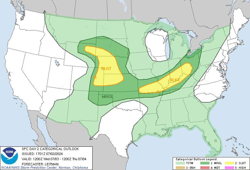
Latest Day 2 Outlook shows that the slight risk has been shifted futher north....North of Tulsa, OK in fact.

Posted: Wed Apr 28, 2004 4:20 pm
by Guest
Brett Adair wrote:Latest Day 2 Outlook shows that the slight risk has been shifted futher north....North of Tulsa, OK in fact.

It is nosing into southeast Neb./Sw Ia. In fact, the Omaha NWS has went along with the SPC (for NOW) in this thinking. Might be able to get something out of this system still.
Posted: Wed Apr 28, 2004 4:34 pm
by wx247
I love that graphic... sometimes I wonder how they draw those pictures.

Posted: Wed Apr 28, 2004 4:37 pm
by Brett Adair
Yeah.....it is fairly easy. We use PHP to do ours.
Severe Weather Division
Posted: Wed Apr 28, 2004 5:05 pm
by USAwx1
also, additional convective development may occur overnight north of the boundary as the LLJ intensifies.
Posted: Wed Apr 28, 2004 5:27 pm
by wx247
I meant the shape.

How they can make such a shape and that severe weather is only likely in that area.

Posted: Wed Apr 28, 2004 5:51 pm
by Brett Adair
wx247 wrote:I meant the shape.

How they can make such a shape and that severe weather is only likely in that area.

LOL....I have been a total clutz today! Well yeah I agree.....their outlook outlines are wonderful arent they....

Posted: Wed Apr 28, 2004 7:15 pm
by USAwx1
will have to see what becomes of the closed upper low across the four corners region as it ejects out into the plains. IF the digging northern branch s/w is stronger and the trough more amplified per the GFS, then phasing should occur.
FRI will be an interesting day over much of OK, TX and LA with excellent instability in place. LI's running as low as -10, and SB CAPE in excess of 2500 J/kg. convective initiation dependencies will be similar to those of tomorrow with emphasis on LLVL boundaries as the focus.
Mid Level lapse rates are pretty impressive too, mostly between 8.0-9.0 DEG C/km.


