Page 1 of 5

IF you live in the Northeast and want warm wx...

Posted: Thu Oct 21, 2004 4:53 pm
by wxguy25
Forget about it.

YET ANOTHER significant blocking episode likely to set up for the end of OCT.

The cutoff upper low off the east coast on D4 (Monday) should lift northward and eventually phase with PJ energy on WED developing huge and cold Newfoundland low by D7.

http://vortex.plymouth.edu/gifs/041021202811.gif

The development of the closed low will pump the downstream ridge toward Greenland and send the NAO negative. Notice the OMEGA-STYLE block located right above the 50/50 low indicative of a strong –NAO

http://vortex.plymouth.edu/gifs/041021203118.gif

Notice even out to day 10 how the REX Blocking pattern (and split flow) over the Northwest Atlantic remains in tact. This is a COLD PATTERN for the northeast and one that one would have to watch extremely closely for big trouble if this were the middle of winter or even DEC for that matter.

Here are the NAO ensembles which support the ECMWF’s interpretation

Image

EXTREMELY cold times would be ahead for the EUS if we had a favorable east pacific signal, but since we don’t it’s a war of the teleconnetions w/ the PNA indicating the trough in the west and the strong PAC jet courtesy of the +EPO arguing for the development of the dreaded plateau high.

Why is the EPO positive? It’s the result of the positioning of the PV over eastern Asia into far western North America w/ ridging to the south of it over the North PAC. What happens is the height gradient increases over a shorter distance (note the tightly packed 500mb Isohypses over the north pacific near/west of the Aleutian Islands) resulting in the intensification of the jet over the north pacific-- You can see that clearly by taking a look at the length of the arrows on the 500mb plot above.

http://vortex.plymouth.edu/gifs/041021205808.gif

The central US will continue to be under the influence of the ridge for the time being, which will help to keep things near or above normal in that region through D10 but for the northeast, no such luck. Note the 5400m eights over the northeast on the D8-10 average valid at 0z on 10/31.

http://vortex.plymouth.edu/gifs/041021205951.gif

Bottom line, NO pronounced or long-lasting EUS warm up through the end of the month.

Now b/c im ambitious, well take a look even further out into NOV, where I believe two things will be critical to determining how things unfold.

1… +EPO / -PNA and strong corresponding PAC jet (as long as the SSTA profile doesn’t change on me during the month, which is something im afraid of happening). This results in a strong plateau high and downstream ridge over the EUS. Cool/stormy pattern in the west.

2… Frequently –NAO helping to keep the ridge suppressed in the east and warm-ups short lived.

The Eastern Pacific signal is in the most Jeopardy of changing. IF the warm water gets into the GOA during the middle to later half of the month and a cool pool forms northwest of Hawaii like NOV/DEC 2002 the trough will head right back into the EUS in the means since the PAC jet is choked off, and you get the tendency for a split flow and mainly +PNA.

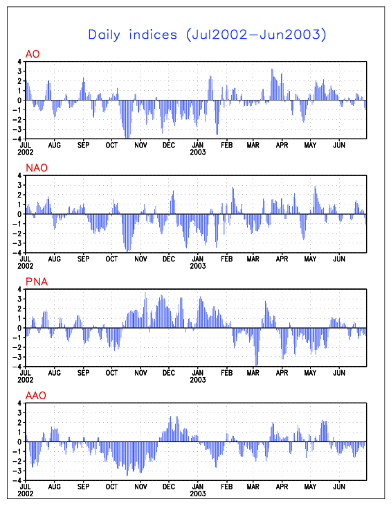
Here are the verifications from 2002-03

http://www.cpc.ncep.noaa.gov/products/p ... x.2002.gif

Now compare that to the SSTA profile in OND-NDJ 2002-03. You should also check out the 1993-94 and 1986-87 set-ups, they are equally impressive.

http://www.longpaddock.qld.gov.au/Seaso ... 02/Oct.gif
http://www.longpaddock.qld.gov.au/Seaso ... 02/Nov.gif
ttp://www.longpaddock.qld.gov.au/Season ... 02/Dec.gif
http://www.longpaddock.qld.gov.au/Seaso ... 03/Jan.gif

The GFS ensembles show much of the same through NOV 5 w/ blocking over the North Atlantic that at times may extend into QUEBEC, Baffin Island and over the Davis Strait opposing the –PNA pattern and Pacific jet.

http://www.cdc.noaa.gov/map/images/ens/ ... times.html

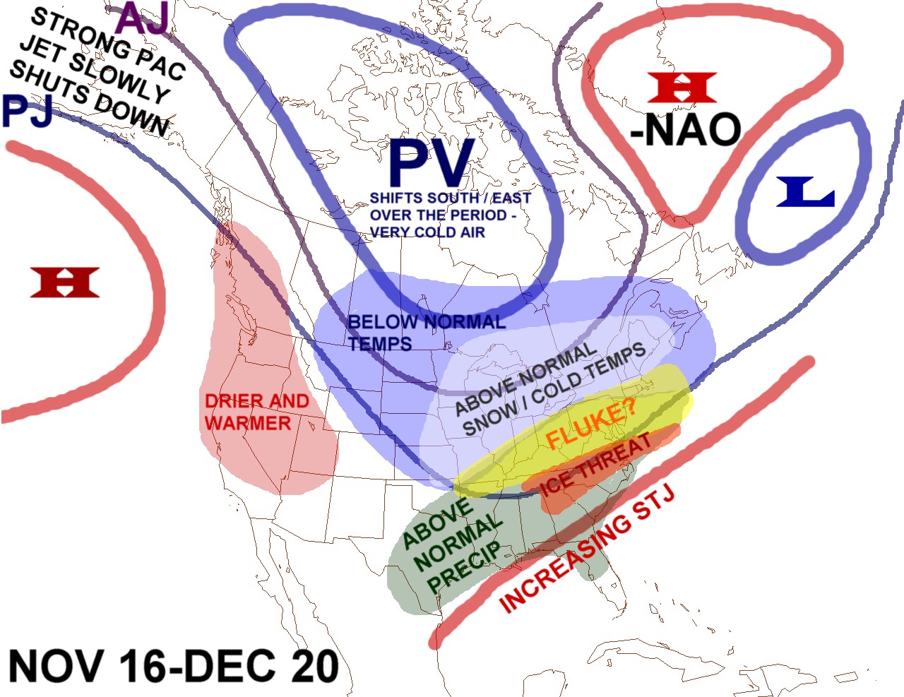
Basic idea here is that November or at leas the first 15 days of the month should play out like I have said; it’s the later part of the month where things really begin to get interesting. ill elaborate more as time goes on.

Posted: Thu Oct 21, 2004 8:05 pm
by yoda
Good post and thanks for the cold... I mean good news! :D

Posted: Thu Oct 21, 2004 8:06 pm
by Wnghs2007
yoda wrote:Good post and thanks for the cold... I mean good news! :D


LOL. Its mister poster......errr....I mean Yoda :D :P :hehe:

Posted: Thu Oct 21, 2004 11:07 pm
by wxguy25
Thanks. My winter outlook will discuss these issues in much greater depth. My winter outlook has been finished since monday, however now its just a matter of actually getting it online. I apologize for the delay.

BTW, KC...I anticipate 1-4 inches of snow in Atlanta this winter. temperatures 3+ Below normal.

Posted: Thu Oct 21, 2004 11:10 pm
by yoda
wxguy25 wrote:Thanks. My winter outlook will discuss these issues in much greater depth. My winter outlook has been finished since monday, however now its just a matter of actually getting it online. I apologize for the delay.

BTW, KC...I anticipate 1-4 inches of snow in Atlanta this winter. temperatures 3+ Below normal.


That is alright. Take your time to post your winter outlook.

Posted: Thu Oct 21, 2004 11:11 pm
by Anonymous
This forecast really breaks my heart.

All I wanted was a little bit of warm weather for my jebwalk. I wanted to enjoy a jebwalk in 77/64 conditions, just one more warm OBX-like jebwalk.

Now I won't get it. :cry: :cry: :cry: :cry: :cry: :cry: :cry: :cry: :cry: :cry: :cry: :cry: :cry: :cry: :cry: :cry: :cry: :cry: :cry: :cry:

All I wanted was one more 77/64 jebwalk. Just one last bit of fresh, moist warm OBX weather to enjoy my jebwalk in, I was going to go for my record Texas jebwalk distance of 9.3 miles that I set at Mustang Island on the Texas coast back on August 22 this summer.

Now I'll never get to enjoy it.

Nature is a cruel beast.

First my precious OBX trip that I waited for all year was cold, with a windy, chilly 65/45 T/Td spread. It was so cold at Nags Head when I was there Oct 7 through 11, that my friends and I nearly caught colds from playing water volleyball in the pool there at 6905 S. Va. Dare Trail on Oct 10. It was 61 degrees accompanied by 46-degree dewpoints with 20-mph N winds that produced windchills in the low 40s. I was so cold I could hardly believe it. We were all trying to get as close as possible to the hot water jet in the pool to stay warm, it was so darn cold on the OBX while we were there!!

Now that d@mn negative NAO is going to cruelly stomp all over my precious OBX weather jebwalk that I wanted so badly. I just wanted one last day or two of 77/64 temperature/dewpoint spread so I could enjoy one last OBX-like jebwalk, conducting the jebwalk in that OBX-like weather while imagining I was still at the Outer Banks.

I need to move very, very far south. It's way too cold here in Virginia for this time of year. Our normal high is 68 and we've been stuck in the low 50s for most of the week.

:cry: :cry: :cry: :cry: :cry: :cry: :cry: :cry: :cry: :cry: :cry:

Posted: Thu Oct 21, 2004 11:12 pm
by Wnghs2007
wxguy25 wrote:Thanks. My winter outlook will discuss these issues in much greater depth. My winter outlook has been finished since monday, however now its just a matter of actually getting it online. I apologize for the delay.

BTW, KC...I anticipate 1-4 inches of snow in Atlanta this winter. temperatures 3+ Below normal.


Ice storms? :slime:

What can I say. I like to watch it accumulate, and its so beautiful. Until you lose power.

Posted: Fri Oct 22, 2004 10:05 pm
by Seele
Wooo! Hope your right about the Atlanta snow :cheesy: Didn't have much more than a dusting last year.

Though you can keep the ice over in Gwinnett Wnghs, I like my power :P

Posted: Fri Oct 22, 2004 10:48 pm
by Anonymous
How much snow down here in Fla??? White christmas on tap in Jax!!! Havent seen any lately--kindof a deficit in snowfall IMHO :?: Yes/No/Maybe?

Posted: Sat Oct 23, 2004 12:53 pm
by wxguy25
Jekyhe32210 wrote:How much snow down here in Fla??? White christmas on tap in Jax!!! Havent seen any lately--kindof a deficit in snowfall IMHO :?: Yes/No/Maybe?


JAX only averages 0.01" of snow per year, and the most since 1950 was about 2" during the extreme winter of 1957-58.

My analog years all had zero inches at JAX, which of course as you know when averaged out for 5 seasons--yields zero inches. there is the concern though given that a majority of the years where JAX did recieve accumulating snowfall were El Nino years like this will be. Temperatures on the other hand are probably going to be a bigger story w/ the potential for a major freeze through the state this year. as you will see in the winter outlook (which will be out in the newsletter) I anticipate the core of the below normal temperatures to be located over the Southeast.

Id be seriously remiss to imply that there will not be any accumulating snow in JAX given the southern storm track, potential for major cyclogenesis along the southeast coast and the idea that temperatures will average WELL below normal. So, overall, I would give JAX a 60-40 shot at accumulating snowfall this winter.

Posted: Sat Oct 23, 2004 7:01 pm
by Anonymous
wxguy25 wrote:
Jekyhe32210 wrote:How much snow down here in Fla??? White christmas on tap in Jax!!! Havent seen any lately--kindof a deficit in snowfall IMHO :?: Yes/No/Maybe?


JAX only averages 0.01" of snow per year, and the most since 1950 was about 2" during the extreme winter of 1957-58.

My analog years all had zero inches at JAX, which of course as you know when averaged out for 5 seasons--yields zero inches. there is the concern though given that a majority of the years where JAX did recieve accumulating snowfall were El Nino years like this will be. Temperatures on the other hand are probably going to be a bigger story w/ the potential for a major freeze through the state this year. as you will see in the winter outlook (which will be out in the newsletter) I anticipate the core of the below normal temperatures to be located over the Southeast.

Id be seriously remiss to imply that there will not be any accumulating snow in JAX given the southern storm track, potential for major cyclogenesis along the southeast coast and the idea that temperatures will average WELL below normal. So, overall, I would give JAX a 60-40 shot at accumulating snowfall this winter.


Hmmm--Sounds like an alright chance for snow this winter as Jacksonville snow chances go :lol: Guess its better than if a LaNina year :wink: Interresting about the below normal Temps... I was under the impression that the below normal temps would be due more to the increase cloudiness/rain caused by El Nino than arctic outbreaks--Like I remember the El Nino 1998 as very stormy but not very cold but was probably below norma because of so many stormy days. But you're sayying that there will be more arctic air this year? Maybe some days with teens for lows/highs struggling to reach 40? :froze: Thats what I consider about as cold as it gets around here.
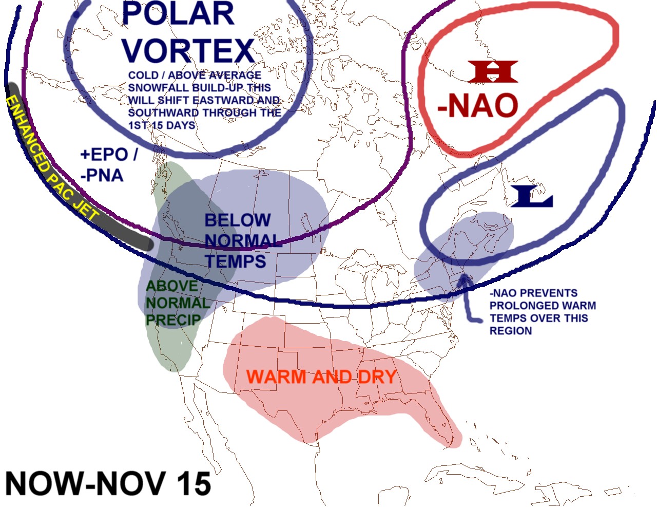
Posted: Sat Oct 23, 2004 7:36 pm
by Stormsfury
THe 1997-1998 El Niño simply overwhelmed the weather pattern and bumped the Northern Jet too far north, essentially locking the arctic air completely out of the picture ... the SBJ simply dominated the weather in the Southern Tier that year, including many SVR WX outbreaks in the heart of winter .. and an unusual situation where TWO MAJOR storms developed within 12 hours in January, dumping over 5" of rain in Charleston, SC in a 24 hour period from the two separate storms ...

This year's El Niño will NOT be the case ...

SF

Posted: Sat Oct 23, 2004 8:21 pm
by wxguy25
Your right, JEK about the clouds and precip across the SE being the primary contributing factor toward the below normal temps over the SE since the clouds block incoming solar radiation from reaching the surface rather than arctic air masses being the primary origin—however that DOESN’T apply during all El Nino events, and ESPECIALLY those which are of weak or moderate intensity.

And to build on what SF mentioned-- To understand why strong El Nino events do this you have to be aware of the reason why the strength and location of the El Nino and the state of the large scale cyclical patterns in the pacific such as the PDO is critical. Those in El Nino events in the PDO warm phase are Stronger, and more persistent than those in the cold phase b/c of the large scale / long term mean SSTA configuration over the ENTIRE PAC BASIN--Where you have Anomalously Cold water in the North pacific, and south pacific with warm water wedged in the middle of the two cold pools. See link below for more info.

http://www.jisao.washington.edu/pdo/

With a strong El Nino events in the EPAC, the associated deep tropical convection resulting from the positive SSTA in the region causes and eastward extension of the sub-tropical ridges in both the NH and SH, resulting in an increase in the strength of the jet along the poleward side of the ridges and equatorward displacement of the jet so the feedback mechanism develops a large strong low pressure area over the North Pacific. The strong low pumps warm air downstream of it leading to ridging and subsidence over western North America--which modifies arctic highs as they try to move southward. Not to mention you also can get a strong net warm effect globally during strong El Nino events like 1997-98, and extratropical systems with a warmer than normal mid and upper level structure—also promoting a better likelihood for liquid precipitation.

When you lack a strong El Nino the said effects are not only mitigated, but if the core of the warm SSTA are located further west over the central or western pacific (NINO 3.4 or 4.0 region) the eastern equatorial pacific will be cooler which means that not as much heat and gets pumped into systems downstream since most of the heat and energy goes into the production of the storms. In other words you get the El Nino storms and enhanced STJ w/o the strong El Nino warmth and upper air pattern. You also open up the potential for cold air to accumulate in Canada since the source regions aren’t flooded w/ polar pacific air, and w/ a predisposition towards a EUS trough and –NAO it can and does release it into the EUS.

Plus El Nino events in the PDO cold phase tend to have above average EUS snowfall and a better chance for Major east coast snow events, the reason likely b/c of the STJ interacting w/ the cold air.

Posted: Sat Oct 23, 2004 9:17 pm
by deguy50
thanx for the great info

Posted: Sat Oct 23, 2004 9:57 pm
by wxguy25
12z european showing some changes. Trough over the western US splits on THU and FRI leaving a piece behind off the CA coast that gets cutoff from the flow. this would cause the jet to be forced to go around it and the trough would end up back in the east. NAO is neutral to negative through the period as the block tries to come back from Scandinavia. Slightly different theory from the ideas expressed in my first post but more or less the same result.

http://vortex.plymouth.edu/gifs/041024025424.gif

Posted: Sat Oct 23, 2004 10:51 pm
by wxguy25
here is the basic idea on where I see the pattern heading from the start of next week to around Xmas.

I split the graphics into the two different periods. the first covering The final week of OCT through at least NOV 15, and the other NOV 15 to DEC 20.

Image

Image

Basic idea here is that the warm pool over the North PAC migrates slowly eastward into the Gulf of AK, and the mean PV in the transitions southeastward w/ time in time so that it ends up in North central canada by the end of DEC after starting out over Eastern Siberia, western AK and extreme western north America. This will prompt the changes in the pattern.

Also let me know what you think of the graphics. If you like them...I will use them more often.

Posted: Sat Oct 23, 2004 11:34 pm
by BL03
Nice to see you posting again!
Very good posts here and very reasonable. Agree with what you have in these graphics in terms of the pattern slowly changing into nov-dec with the PV moving back and the trof moving back over the lakes and east. I also see a very good start to winter in the mid-west, and lakes during this change and then should sprend into the NE and maybe Mid Atl during time. I see you have a possible Fluke for the NE....hope your right! I wouldn't be surprised if there was something possible around dec 18-30 for the NE hopefully the pattern locks in then with a nice event starting the winter off for the east. :D If everything goes as planed then I expect a colder than normal and above avg snowfall winter for the NE but snowfall will be a hard call because one big storm could make or break a forecast in this kind of winter esp for coastal areas, but it looks good as of now esp the second half for coastal areas. Storms might trend to be strong with the active STJ and there might be a few bombs off the coast which should help in terms of precip and snowfall for the NE. I expect at least one big event from PHL on north in FEB-early Mar but dont get me wrong there will be many chances for many areas including the lakes, mid-west, NE, Mid Atl.

BTW nice graphics.

Posted: Sat Oct 23, 2004 11:54 pm
by wxguy25
I agree, I think there may be some sort of significant event around or after Xmas like 1966, 1969. The idea of the Fluke applies mostly to the end of NOV but overall near normal snowfall is a good bet in the "Fluke" region. ice storm threat and big one at that further south. The worry here is that the pattern transitions more quickly within a few weeks vs a month.

El nino/ west winters are noted for having plenty of blocking, split flow, cutoff systems which move very slowly, and deep nor'easters. Unlike 2002-03, I think the QBO will wait until JAN or FEB to turn negative again...or remain positive for at least 60% of the meteorological winter, so once the classic el nino- west pattern sets in, the fun will begin along the East coast.

the rest is covered in the winter outlook which will be out in the upcoming s2k newsletter.

Posted: Sun Oct 24, 2004 12:22 am
by Wnghs2007
wxguy25 wrote:I agree, I think there may be some sort of significant event around or after Xmas like 1966, 1969. The idea of the Fluke applies mostly to the end of NOV but overall near normal snowfall is a good bet in the "Fluke" region. ice storm threat and big one at that further south. The worry here is that the pattern transitions more quickly within a few weeks vs a month.

El nino/ west winters are noted for having plenty of blocking, split flow, cutoff systems which move very slowly, and deep nor'easters. Unlike 2002-03, I think the QBO will wait until JAN or FEB to turn negative again...or remain positive for at least 60% of the meteorological winter, so once the classic el nino- west pattern sets in, the fun will begin along the East coast.

the rest is covered in the winter outlook which will be out in the upcoming s2k newsletter.


ICE THREAT ICE THREAT. KC HYPER MODE INGAGED........WINTER COUNT DOWN BEGINS. KC HEAD EXPLOSIN IN 15 MINUTES OF CONSTINENT WAITING AND THINKING :roflmao:

Posted: Sun Oct 24, 2004 9:14 am
by Anonymous
Thanks for the in depth analysis wxguy25 !

I must strongly agree that a major warm pattern appears UNLIKELY in the East CONUS through Nov.7, like some have contented. Too much troughing/cold lows Eastern Canada dominating these areas during the period despite RNA pattern/trough out west. Even after slight warmup later this week (FRI/SAT) middle Atlantic/SE, at least seasonable temperatures will return from Halloween through Nov.7 timeframe as trough (Oct.31) over Great Lakes south to TN Valley moves east. This was depicted quite clearly on the 168hr 12z Euro run valid Oct.31 as well. Plus most of the 0z/6zGFS runs through Nov.7 show the 564DM line extending fairly far south across the SE states.

So major warm pattern through early Nov ? I don't think so.