Page 1 of 1

Tornado Watch East Alabama/Georgia/North Florida

Posted: Sun Mar 27, 2005 5:47 pm
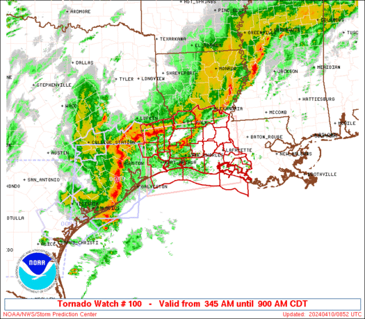
by Brent
Image

URGENT - IMMEDIATE BROADCAST REQUESTED
TORNADO WATCH NUMBER 100
NWS STORM PREDICTION CENTER NORMAN OK
525 PM EST SUN MAR 27 2005

THE NWS STORM PREDICTION CENTER HAS ISSUED A
TORNADO WATCH FOR PORTIONS OF

EASTERN ALABAMA
NORTHERN FLORIDA
WESTERN AND CENTRAL GEORGIA
COASTAL WATERS

EFFECTIVE THIS SUNDAY AFTERNOON AND MONDAY MORNING FROM 525 PM
UNTIL 100 AM EST.

TORNADOES...HAIL TO 2 INCHES IN DIAMETER...THUNDERSTORM WIND GUSTS
TO 80 MPH...AND DANGEROUS LIGHTNING ARE POSSIBLE IN THESE AREAS.

THE TORNADO WATCH AREA IS APPROXIMATELY ALONG AND 95 STATUTE MILES
EAST AND WEST OF A LINE FROM 45 MILES NORTH OF ROME GEORGIA TO 55
MILES SOUTH SOUTHEAST OF TALLAHASSEE FLORIDA. FOR A COMPLETE
DEPICTION OF THE WATCH SEE THE ASSOCIATED WATCH OUTLINE UPDATE
(WOUS64 KWNS WOU0).

REMEMBER...A TORNADO WATCH MEANS CONDITIONS ARE FAVORABLE FOR
TORNADOES AND SEVERE THUNDERSTORMS IN AND CLOSE TO THE WATCH AREA.
PERSONS IN THESE AREAS SHOULD BE ON THE LOOKOUT FOR THREATENING
WEATHER CONDITIONS AND LISTEN FOR LATER STATEMENTS AND POSSIBLE
WARNINGS.

OTHER WATCH INFORMATION...CONTINUE...WW 97...WW 98...WW 99...

DISCUSSION...WITH POWERFUL UPPER TROUGH AND ASSOCIATED 100KT MID
LEVEL JET MAX MOVING ACROSS SERN U.S. OVERNIGHT...SEVERE
THUNDERSTORM POTENTIAL WILL CONTINUE AHEAD OF COLD FOTN NOW MOVING
INTO WRN AL. WITH STRONG DEEP LAYER SHEAR AND INFLUX OF VERY
MOIST/UNSTABLE AIRMASS...SUPERCELLS AND TORNADOES WILL CONTINUE TO
BE A THREAT. ADDITIONALLY DAMAGING WINDS WILL BECOME MORE LIKELY AS
SQUALL LINE DEVELOPS DURING EVENING.

Posted: Sun Mar 27, 2005 6:21 pm
by Guest
This is what caught my attention!!
MODIFIED 12Z SOUNDINGS SHOWED CAPES OF OVER 2500 J/KG POSSIBLE
This is from the Jax AFD at:
http://www.srh.noaa.gov/jax/cgi-bin/tex ... &name=Area\sForecast\sDiscussion
I have been looking at the visiible sat most of the afternoon, amnd the supercell development has been awesome. I'm getting really concerned for areas from Ocala north into Georgia. The new tornado watch doesn't cover Baker County, just east of the box, But, I have a feeling we may see all of North Florida and Southern Georgia in a new box that should be issued by 8pm/et.
This will be a very stormy night for all of North Florida!!
I'll post an update on Monday to let you know how the line came through!

Posted: Sun Mar 27, 2005 6:34 pm
by Rainband
stay safe Bob. Nice to see you. Looks like our area may get a bit of rain but I have been watching the satellite today and it seems to weaken as it gets closer. It is very humid here so it may get stronger as the night progresses

Posted: Sun Mar 27, 2005 8:20 pm
by Guest
The squall line is really beginning to take shape now as it past Appalachacola.
http://www.spc.noaa.gov/exper/mesoanaly ... s/rgnlrad/
Looks like around 11pm for passage in my area. For those of you that don't know where I am, I am in Baker Couty, half way between Jacksonville and Lake City Florida. We had a possible tornado in Union County on Frida around 10am, this caused a severe thunderstorm warning to be generated for Baker.
Whats bothering me is, the angle of the tornado watch box (north to south) This shows that the front is still negativly tilted. This is going to be one of the first stormiest nights since Jeanne!
I have my NOAA Weather Radio on stand-by, hehe same as I have been giving away on the shows, works darn good.

Posted: Sun Mar 27, 2005 8:33 pm
by Rainband
stay safe and keep us posted :wink:

Posted: Sun Mar 27, 2005 9:21 pm
by Rainband
the satellite loops I have been looking at look like this line is losing it's punch?? What are you seeing??

Posted: Mon Mar 28, 2005 3:06 pm
by Guest
yep it lost it's punch completely!!!
It was rather windy this morning, still a bit gusty, but not 1 thuinderstorm for my area over night.
All of the energy shifted southward, this makes the 3rd system to loose some of it's energy as it approached NE Florida.
It can send the wrong message, especially when severe weather does occur.