Warm April Pattern Likely to Begin Just Before Mid-Month
Posted: Mon Apr 04, 2005 4:17 pm
Currently, although the 4/4/2005 12z run of the GFS argues for caution, it is likely that the evolution of the current pattern should lead to readings generally averaging above normal in the East for much of the second half of April (probably at least April 13 through April 25).
ENSO Analogs:
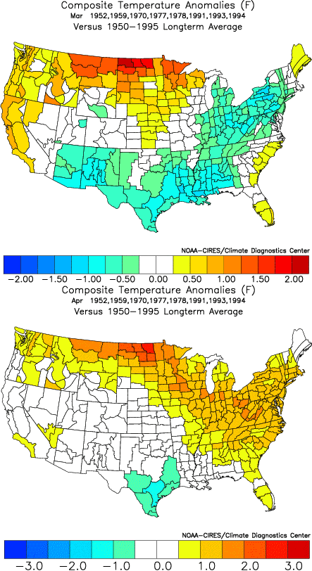
As a general rule, in times of changing patterns where uncertainty is highest, analogs can provide invaluable guidance. Based on late February data (which has continued to be supported by weekly ENSO data through March 23), odds favor a warm April in the East:
Closest 15 Matches:
• Northeast: 11/15 (73%) normal to above normal temperatures
• Mid-Atlantic: 12/15 (80%) normal to above normal temperatures
• Southeast: 13/15 (87%) normal to above normal temperatures
Closest 10 Matches:
• Northeast: 8/10 (80%) normal to above normal temperatures
• Mid-Atlantic: 8/10 (80%) normal to above normal temperatures
• Southeast: 8/10 (80%) normal to above normal temperatures

Major Teleconnection Indices:
There is now strong support on the GFS ensembles for the NAO to go positive just prior to April 10. This development is supported by the GFS ensemble forecast for the Arctic Oscillation (AO). Since 1950, 77% of cases that saw the AO average positive in April also saw the NAO average positive. This timing is also consistent with the breakdown of past extreme blocks.
Positive NAO-Positive PNA:
• Very warm, on average in the East
• Cool anomalies are very unlikely in the Mid-Atlantic and Northeast
• New England is often wet
Positive NAO-Negative PNA:
• Chance for an outbreak of extreme warmth in the East
• Near normal in the Southeast and often somewhat below normal to near normal in the New England; Mid-Atlantic is typically warm
• Dry in the East
“Fire” in April:
15 of 20 (75%) of some of the most prominent outbreaks of heat in April were preceded by a positive NAO at least 5 days prior to the start of the event. 14 of those 15 (93%) cases had a positive NAO at the start of the event. 12 of 15 (80%) of those cases had a negative PNA at the start of the event. Outbreaks of heat that met all the above criteria (positive NAO 5 days before the start of the event, positive NAO at the start of the event, and a negative PNA at the start of the event) included the April 1976, April 1990, April 1991, and April 2002 outbreaks of heat. Needless to say, not every such situation with the global teleconnection indices led to an impressive outbreak of heat.
Madden-Julian Oscillation (MJO):
The Madden-Julian Oscillation (MJO) has just moved into Phase 4. Phases 4-6 are typically associated with the development of a positive NAO and ridging in the East. Phase 7, which is often associated with the start of a transition that leads to the return of a negative NAO, is probably 15-21 days away.
ECMWF Model:
The 8-10-day average for the 4/4 2005 0z run of the ECMWF tended to support a ridge in the East/trough in the West alignment. It also lent some support to the idea of a positive NAO.
CPC’s Ensemble Composite Analog for 500 mb Height Anomalies:
The 8-14-day forecast centered on April 15 produces analogs that overwhelmingly had warmer than normal readings in part or all of the East for the 3 days prior to and after the date cited. Analogs were: May 1, 1955, April 24, 1960, May 2, 1964, April 19, 1977, and April 4, 1999. The 6-10-day pool was cooler. This trend among the ensemble composite analogs adds to confidence in the idea that a transition to a warmer pattern will be occurring just before mid-month.
Consistency of Signals:
• Pattern Change: ENSO analogs, GFS Ensembles, MJO, ensemble composite analogs
• Positive NAO: Evolution of Extreme Blocks, NAO climatology, MJO, GFS Ensembles (both NAO and AO), ECMWF
• Above Normal Temperatures: ENSO analogs, GFS Ensembles (NAO signal), NAO-PNA profiles
Overall, I have average confidence that a warm pattern will likely commence in the East in the April 13-15 timeframe. After that, it should persist with at least 10-14 days seeing readings generally averaging above normal. Overall, the April 13-25 period will likely see readings in Boston, New York City, Philadelphia, and Washington, DC average above normal. The Mid-Atlantic region could see the largest warm anomalies and April 2005 could see a monthly mean temperature at or above 58° for Washington, DC.
Unlike with the pattern change idea for mid-February, there is greater uncertainty this time around. The seasonal transition also increases the uncertainty. The above idea will be verified at the end of April.
ENSO Analogs:
As a general rule, in times of changing patterns where uncertainty is highest, analogs can provide invaluable guidance. Based on late February data (which has continued to be supported by weekly ENSO data through March 23), odds favor a warm April in the East:
Closest 15 Matches:
• Northeast: 11/15 (73%) normal to above normal temperatures
• Mid-Atlantic: 12/15 (80%) normal to above normal temperatures
• Southeast: 13/15 (87%) normal to above normal temperatures
Closest 10 Matches:
• Northeast: 8/10 (80%) normal to above normal temperatures
• Mid-Atlantic: 8/10 (80%) normal to above normal temperatures
• Southeast: 8/10 (80%) normal to above normal temperatures

Major Teleconnection Indices:
There is now strong support on the GFS ensembles for the NAO to go positive just prior to April 10. This development is supported by the GFS ensemble forecast for the Arctic Oscillation (AO). Since 1950, 77% of cases that saw the AO average positive in April also saw the NAO average positive. This timing is also consistent with the breakdown of past extreme blocks.
Positive NAO-Positive PNA:
• Very warm, on average in the East
• Cool anomalies are very unlikely in the Mid-Atlantic and Northeast
• New England is often wet
Positive NAO-Negative PNA:
• Chance for an outbreak of extreme warmth in the East
• Near normal in the Southeast and often somewhat below normal to near normal in the New England; Mid-Atlantic is typically warm
• Dry in the East
“Fire” in April:
15 of 20 (75%) of some of the most prominent outbreaks of heat in April were preceded by a positive NAO at least 5 days prior to the start of the event. 14 of those 15 (93%) cases had a positive NAO at the start of the event. 12 of 15 (80%) of those cases had a negative PNA at the start of the event. Outbreaks of heat that met all the above criteria (positive NAO 5 days before the start of the event, positive NAO at the start of the event, and a negative PNA at the start of the event) included the April 1976, April 1990, April 1991, and April 2002 outbreaks of heat. Needless to say, not every such situation with the global teleconnection indices led to an impressive outbreak of heat.
Madden-Julian Oscillation (MJO):
The Madden-Julian Oscillation (MJO) has just moved into Phase 4. Phases 4-6 are typically associated with the development of a positive NAO and ridging in the East. Phase 7, which is often associated with the start of a transition that leads to the return of a negative NAO, is probably 15-21 days away.
ECMWF Model:
The 8-10-day average for the 4/4 2005 0z run of the ECMWF tended to support a ridge in the East/trough in the West alignment. It also lent some support to the idea of a positive NAO.
CPC’s Ensemble Composite Analog for 500 mb Height Anomalies:
The 8-14-day forecast centered on April 15 produces analogs that overwhelmingly had warmer than normal readings in part or all of the East for the 3 days prior to and after the date cited. Analogs were: May 1, 1955, April 24, 1960, May 2, 1964, April 19, 1977, and April 4, 1999. The 6-10-day pool was cooler. This trend among the ensemble composite analogs adds to confidence in the idea that a transition to a warmer pattern will be occurring just before mid-month.
Consistency of Signals:
• Pattern Change: ENSO analogs, GFS Ensembles, MJO, ensemble composite analogs
• Positive NAO: Evolution of Extreme Blocks, NAO climatology, MJO, GFS Ensembles (both NAO and AO), ECMWF
• Above Normal Temperatures: ENSO analogs, GFS Ensembles (NAO signal), NAO-PNA profiles
Overall, I have average confidence that a warm pattern will likely commence in the East in the April 13-15 timeframe. After that, it should persist with at least 10-14 days seeing readings generally averaging above normal. Overall, the April 13-25 period will likely see readings in Boston, New York City, Philadelphia, and Washington, DC average above normal. The Mid-Atlantic region could see the largest warm anomalies and April 2005 could see a monthly mean temperature at or above 58° for Washington, DC.
Unlike with the pattern change idea for mid-February, there is greater uncertainty this time around. The seasonal transition also increases the uncertainty. The above idea will be verified at the end of April.

