Page 1 of 1
Cyclonic Storm in North Carolina
Posted: Sun Nov 12, 2006 2:46 pm
by jimvb
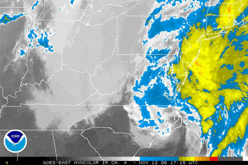
Look at the radar this afternoon (2006 Nov 12 about 3 pm EST). There seems to be a hurricane centered around Edenton or Elizabeth City, North Carolina. I don't think it could be that because the time of the year and the ocean are wrong, and because there does not seem much stronger than a strong breeze or a weak gale associated with it. But it sure looks like one, with a large central portion ("eye"?) and waves of storms coming from the eastern and NE sides of the cyclone. Seems like a northeaster to me. It reminds me of the storm of 1993 March 12 ("Bluto"), which put down 20 inches of snow in Lynchburg, VA, and a 28.47 barometric reading here - lower than in many major hurricanes. The weather here in Richmond is rainy, cold (45 degrees) and breezy, and reminds me of the weather with Isabel, Gaston, and Ernesto except for the cold.
Posted: Sun Nov 12, 2006 3:18 pm
by Aquawind
Posted: Sun Nov 12, 2006 4:06 pm
by Tstormwatcher
Its just a low pressure cell. Pressure has been hanging around 29.68 all day and yes it has been raing and very cool all day. 50 F now after a high yesterday of 81.
Posted: Sun Nov 12, 2006 4:33 pm
by brunota2003
AREA FORECAST DISCUSSION
NATIONAL WEATHER SERVICE NEWPORT/MOREHEAD CITY NC
1210 PM EST SUN NOV 12 2006
.SHORT TERM /REST OF TODAY/...SURFACE LOW PRES AND ASSOCIATED COLD
FRONT ARE LIFTING NEWD OFF THE NRN OBX LATE THIS MORNING WITH THE
UPPER LOW ACROSS CENTRAL NC. A WIDE AREA OF WRAP AROUND RAINFALL
IS CONTINUING ACROSS MUCH OF THE WESTERN PORTION OF THE CWA.
TEMPERATURES HAVE FALLEN INTO THE 50S BEHIND THE FRONT AND WINDS
HAVE INCREASED UP TO 15 MPH WITH GUSTS 25-30 MPH AS STRONG CAA HAS
COMMENCED. THE LOW PRES WILL SLOWLY LIFT NEWD THIS AFTERNOON WITH
THE WRAP AROUND RAINFALL SLOWLY ENDING ACROSS THE SERN PORTION OF
THE CWA THIS AFTERNOON. LOW PRES WILL BE SLOW TO PUSH EAST OF THE
VA CAPES TODAY AND TONIGHT AS THE UPPER LOW BECOME CUTOFF ALLOWING
FOR WRAP AROUND RAINFALL TO CONTINUE ACROSS NERN NC THIS AFTERNOON
AND EVENING...WITH COVERAGE DIMINISHING THIS EVENING. UPDATED THE
ZONES AND GRIDS TO CAPTURE CURRENT PCPN AND TEMPERATURE TRENDS.
It actually looked better this morning...right now it looks like a big blob...

Same here Tstormwatcher: cold, wet, and pressure has been between 1008 and 1011 millibars...currently reading 1010.8 millibars...
Posted: Sun Nov 12, 2006 4:43 pm
by brunota2003
also...taking a look at the personal wx stations provided by wx underground...it does appear that the surface low pressure over Hyde County might be slightly (and I do mean slightly) warm-cored...by about a whopping 1 or 2 degrees...but warm-cored nonetheless. However, you must remember that the stations are personal, thus data can and most likely is off...just thought it was interesting...
Posted: Sun Nov 12, 2006 5:13 pm
by Coredesat
The cyclone phase models show cold core, but it still looks very impressive.

Posted: Sun Nov 12, 2006 9:11 pm
by whereverwx
Hmm... now that you posted a picture of it, it is pretty impressive. I think this calls for a loop!
Posted: Sun Nov 12, 2006 9:24 pm
by Stephanie
That's an impressive storm!
