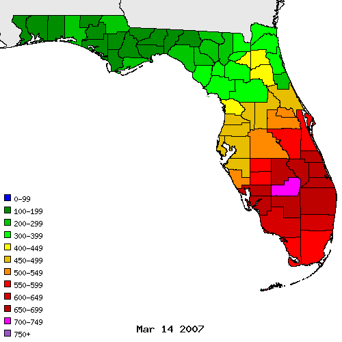
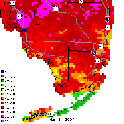
Heavy rainfall across south Florida
Posted: Tue Apr 10, 2007 11:02 pm
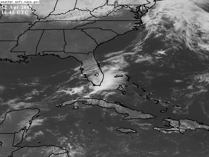
After a short round of severe thunderstorms earlier today in Palm Beach County (with one tornado warning for a cell west of Lake Worth and hail reported in another cell near Boynton Beach) that lingered into the evening, upper-level divergence and low-level water vapor (and a jet streak and subtropical jet influence ahead of a surface front and possible weak shortwave) has boosted widespread showers and isolated thunderstorm activity across the central and southern portions of the Florida peninsula. Heaviest concentrations of precipitation has affected most of the south Florida (Miami NWS) region from Lake Okeechobee southward. Both the southwest and southeast coasts (and the interior) has experienced locally moderate or heavy precipitation totals. Current radar imagery continues to indicate widespread mid-level moisture and precipital water vapor.
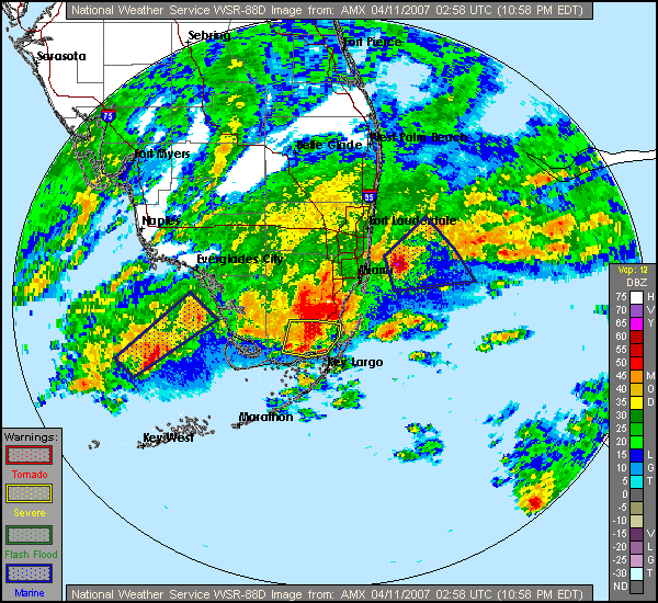
Here is a radar shot from the previous hour.
Miami NWS indicates heavy overnight rainfall is possible for the southern areas due to the shortwave trough over the eastern Gulf of Mexico and slight lifting mechanisms for shower and thunderstorm activity over the southern peninsula. Here is a snippet from the updated portion of the latest forecast discussion.
000
FXUS62 KMFL 110137 AAA
AFDMFL
AREA FORECAST DISCUSSION
NATIONAL WEATHER SERVICE MIAMI FL
935 PM EDT TUE APR 10 2007
.UPDATE...UPDATED ZFP TO INCREASE POPS FOR OVERNIGHT PERIOD. DOPPLER
RADAR CONTINUES TO SHOW SCT/NMRS TSTMS MOVING ENE ACROSS THE
FORECAST AREA...AND SATELLITE IMAGES SHOW A LARGE CONVECTIVE SYSTEM
APPROACHING SOUTH FLORIDA`S SOUTHWEST COAST FROM THE GULF OF MEXICO.
WATER VAPOR IMAGES SHOW A SHORT WAVE MOVING EAST OVER ERN GULF OF
MEX. EXPECT THIS FEATURE TO MOVE OVER THE FORECAST AREA OVERNIGHT.
LEFTOVER OUTFLOW BOUNDARIES FROM AFTERNOON/EVENING CONVECTION WILL
ACT AS A LIFTING MECHANISM TO START CONVECTION WHICH COULD THEN BE
ENHANCED BY THE APPROACHING SHORT WAVE.
WILL ALSO INDICATE WINDS AND SEAS HIGHER OVER ALL COASTAL WATERS AND
BISCAYNE BAY TO ACCOUNT FOR A FEW STRONG STORMS TONIGHT.
The continued precipitation and isolated overnight showers and thunderstorms is indicated in the latest hazards discussion. Here is the latest information.
000
FLUS42 KMFL 110239
HWOMFL
HAZARDOUS WEATHER OUTLOOK FOR SOUTH FLORIDA
NATIONAL WEATHER SERVICE MIAMI FL
1039 PM EDT TUE APR 10 2007
FLZ063-066>075-111430-
GLADES-HENDRY-PALM BEACH WESTERN-PALM BEACH EASTERN-
WESTERN COLLIER-EASTERN COLLIER-WESTERN BROWARD-
BROWARD METROPOLITAN-WESTERN DADE-DADE METROPOLITAN-
MAINLAND MONROE-
1039 PM EDT TUE APR 10 2007
...HEAVY RAINFALL POSSIBLE SOUTHERN AREAS OVERNIGHT...
...A FEW THUNDERSTORMS REMAIN POSSIBLE, MAINLY SOUTH...
...WATERSPOUTS POSSIBLE WITH ANY STORM OVER THE LOCAL WATERS...
THIS HAZARDOUS WEATHER OUTLOOK IS FOR SOUTH FLORIDA.
.DAY ONE...TONIGHT
THUNDERSTORMS: SCATTERED THUNDERSTORMS WILL REMAIN POSSIBLE
OVERNIGHT, MAINLY ACROSS THE SOUTHERN HALF OF THE REGION. ANY
THUNDERSTORM WILL BE CAPABLE OF PRODUCING OCCASIONAL LIGHTNING AND
VERY HEAVY RAINFALL. AREA ROADWAYS WILL REMAIN VERY WET OVERNIGHT,
SO MOTORISTS ARE URGED TO EXERCISE CAUTION IF DRIVING.
FLOODING: VERY HEAVY RAINFALL WILL BE POSSIBLE OVERNIGHT AS RAIN
AND THUNDERSTORMS MOVE TO THE NORTHEAST ACROSS THE SAME AREAS,
MAINLY ACROSS AREAS SOUTH OF A LINE FROM CENTRAL BROWARD COUNTY TO
CENTRAL COLLIER COUNTY. DESPITE THE DROUGHT CONDITIONS CURRENTLY
IN PLACE, SEVERAL INCHES OF RAIN ARE POSSIBLE IN THESE AREAS
OVERNIGHT IN A SHORT PERIOD OF TIME, AND THIS MAY LEAD TO URBAN
AND POOR DRAINAGE FLOODING.
WATERSPOUTS: ANY THUNDERSTORM THAT OCCURS OVER THE GULF OR
ATLANTIC WATERS OVERNIGHT WILL BE CAPABLE OF PRODUCING WATERSPOUTS
AT ANY TIME, AND WITH LITTLE OR NO ADVANCED WARNING. SEEK SAFE
HARBOR WHEN THUNDERSTORMS THREATEN IF IT IS POSSIBLE, AND MOVE
BELOW DECK IF IT IS NOT.
WINDS: A FEW THUNDERSTORMS OVER THE GULF OR ATLANTIC WATERS WILL
BE CAPABLE OF PRODUCING BRIEF WIND GUSTS OF 40 TO 50 MPH
OVERNIGHT, ESPECIALLY OVER THE GULF STREAM.
.DAYS TWO THROUGH SEVEN...WEDNESDAY THROUGH MONDAY
ADDITIONAL THUNDERSTORMS ARE POSSIBLE ACROSS THE AREA OVER THE
NEXT FEW DAYS AS WARM AND HUMID AIR WILL REMAIN IN PLACE.
.SPOTTER INFORMATION STATEMENT...
SPOTTERS ARE ENCOURAGED TO REPORT RAINFALL AMOUNTS OVER 2 INCHES
TO THE NATIONAL WEATHER SERVICE IN MIAMI. OTHERWISE, SPOTTER
ACTIVATION IS NOT ANTICIPATED.
FOR MORE INFORMATION...VISIT THE NATIONAL WEATHER SERVICE IN
MIAMI WEBSITE AT http://WWW.WEATHER.GOV/MIAMI.
$$
STRASSBERG
Source for hazards discussion
In addition, a special marine warning is in effect for a line of offshore thunderstorms east of Miami Beach and Ocean Reef in the upper Florida Keys. A special marine warning is also in effect for the southwest Everglades and islands off Cape Sable.
I finally received thunderstorms and precipitation during the day and I continue to feel the effects of rainfall as I type. Instability has lessened due to nearby outflow and capping inversion; thus, the thunderstorm threat is decreasing but isolated showers and brief thunderstorms should continue through the night before lessening after midnight. This was extremely refreshing and we are finally receiving some temporary drought relief! This extensive event may not have significant long-term effects on the situation but it is better than nothing! In addition, inland areas that desperately needed rainfall (the Everglades, Lake Okeechobee, and interior) have received good coverage from this event.
The negative SOI may have partially contributed to the subtropical jet activity which enhanced this event with the aid of the longwave mid-level trough in the Southeast. Thanks, SOI!
Did anyone else receive rainfall in southern Florida?