
 Yeah, me neither
 Florida Weather
Moderator: S2k Moderators
Forum rules

The posts in this forum are NOT official forecast and should not be used as such. They are just the opinion of the poster and may or may not be backed by sound meteorological data. They are NOT endorsed by any professional institution or STORM2K.
Re: Florida Weather
Anyone ever see Florida gators camouflaged by a thin layer of white snow across their backs? Yeah, me neither  That said, check out the 18Z GFS - 24 hr. Snow Accumulation forecast at 162 hr's. Then toggle 6 hr's later to 168 hr.'s. There ya go folks! Santa seemingly brings a tad bit of frozen precip to SW Florida and perhaps just east of Orlando. Good luck with THAT forecast GFS
Yeah, me neither
3 likes
Personal Forecast Disclaimer:
The posts in this forum are NOT official forecast and should not be used as such. They are just the opinion of the poster and may or may not be backed by sound meteorological data. They are NOT endorsed by any professional institution or storm2k.org. For official information, please refer to the NHC and NWS products.
The posts in this forum are NOT official forecast and should not be used as such. They are just the opinion of the poster and may or may not be backed by sound meteorological data. They are NOT endorsed by any professional institution or storm2k.org. For official information, please refer to the NHC and NWS products.

Re: Florida Weather
FlaWeatherDude wrote:A hard freeze is becoming more likely for Central Florida and could rival Christmas 1983. That year we dipped well down into the 20's Xmas morning! If not at least we will be dealing with Freezing temperatures Christmas weekend!
It will be nothing close to Christmas of 1983 when Orlando International dipped down to a whopping 20 deg F. A period in time when the world was coming out of a mini ice age and the north pole was a lot colder than it currently is.
The Euro has been trending warmer as it gets closer to its 120th hr range. GFS keeps the Arctic high north of central FL unlike the Euro which has it settling over the Peninsula Monday morning thus why it shows forecasted lows even colder on Monday morning, I am sure it will drop that idea as we get closer in time.


2 likes
Re: Florida Weather
I think one big reason we are not going to see temps anywhere close to the records of Christmas 1983 & 1989 is the lack of snow cover across the central US, by this same time both years there was a nice snow pack already in place before the huge Arctic high coming down. Arctic airmasses do not get modified as much when snow cover is closer to the deep south. Then there as that snow across the gulf coast and north FL in 1989.


4 likes
Re: Florida Weather
The period 12/26-8 certainly has had my attention for a few days for a potential significant deep SE wintry precip event. And now check this out! The 12Z JMA at 192 hours (12Z on 12/27) per Tropical Tidbits has a strong wedge extending quite deep into the SE from a 1037 mb NE high and a weak N GOM low forming as the jet buckles. Precip is breaking out before hour 192 (late 12/26-early 12/27) over LA, C and S MS and AL, west central and SW GA, and NW FL with 850s between -2 C and +5C. Based on past Gulf lows with a strong wedge north of them and 850s this cold, this area of precip is likely mostly wintry of various forms, with snow falling in the N portion of the precip from far N LA to part of SW GA (where 850s are below 0C) and IP/ZR due to the strong wedge likely reaching almost to, if not to, the Gulf coast, including much of NW FL and as far SE as near Gainesville.
North Floridians especially, keep an eye out on this period for wintry potential! When FL gets wintry precip, it is usually an anomalous setup. With model progs for near or at an all-time record high barometric pressure for the lower 48 on the morning of 12/22 in MT/WY, we're looking at a very highly anomalous setup to say the least. Huge Arctic highs like this open the door more than usual for FL to get wintry precip., especially with a pretty good +PNA.
North Floridians especially, keep an eye out on this period for wintry potential! When FL gets wintry precip, it is usually an anomalous setup. With model progs for near or at an all-time record high barometric pressure for the lower 48 on the morning of 12/22 in MT/WY, we're looking at a very highly anomalous setup to say the least. Huge Arctic highs like this open the door more than usual for FL to get wintry precip., especially with a pretty good +PNA.
3 likes
Personal Forecast Disclaimer:
The posts in this forum are NOT official forecasts and should not be used as such. They are just the opinion of the poster and may or may not be backed by sound meteorological data. They are NOT endorsed by any professional institution or storm2k.org. For official information, please refer to the NHC and NWS products.
The posts in this forum are NOT official forecasts and should not be used as such. They are just the opinion of the poster and may or may not be backed by sound meteorological data. They are NOT endorsed by any professional institution or storm2k.org. For official information, please refer to the NHC and NWS products.
-
FlaWeatherDude

- Tropical Storm

- Posts: 110
- Age: 39
- Joined: Wed Oct 10, 2018 2:57 pm
- Location: Orlando, FL.
Re: Florida Weather
NDG wrote:I think one big reason we are not going to see temps anywhere close to the records of Christmas 1983 & 1989 is the lack of snow cover across the central US, by this same time both years there was a nice snow pack already in place before the huge Arctic high coming down. Arctic airmasses do not get modified as much when snow cover is closer to the deep south. Then there as that snow across the gulf coast and north FL in 1989.
https://i.imgur.com/A5YWEqi.png
https://i.imgur.com/dGxfz3w.png
https://i.imgur.com/hQoRTTe.png
Good point.
But a big snowstorm is forecasted to dump plenty of snow in much of the Ohio valley and Great Lakes. This should bring the snowpack closer to those years. I'm not going for an exact repeat of those years but I believe models are underestimating cold air evection funneling down the spine of the Peninsula from the newly formed snowpack. Also models often underestimate Greenland blocking til the last minute. So I believe models will trend colder as we get closer(mid-upper 20's Tampa/Orlando. Mid-upper 30's Miami metro). If not then I'll eat crow for Xmas lol.
Late January 2018 and right after New Years 2008 are perfect examples of models adjusting at the last minute.
1 likes
"Windy has wings to fly above the clouds".
-
gatorcane

- S2K Supporter

- Posts: 23499
- Age: 46
- Joined: Sun Mar 13, 2005 3:54 pm
- Location: Boca Raton, FL
Re: Florida Weather
Looks like the Euro and GFS have gone even colder for Central Florida. Looks like a significant, widespread freeze event which could cause some damage.


1 likes
Re: Florida Weather
Yes, likely at least widespread light to moderate freeze for all of interior central FL for both Friday night and Saturday night.
The only good news is that the Euro dropped the 3rd night of freezing for Sunday night and agrees with the GFS in the Arctic high not settling over central FL, a moderate freeze with heavy frost would had been even more devastating.
South FL may not get as cold Sunday morning because of high cloud cover forecasted to move in by both GFS and Euro as a shortwave rotates around the SE US.
Last edited by NDG on Tue Dec 20, 2022 3:14 pm, edited 1 time in total.
2 likes
Re: Florida Weather
Duplicate
Last edited by NDG on Tue Dec 20, 2022 3:14 pm, edited 1 time in total.
1 likes
Re: Florida Weather
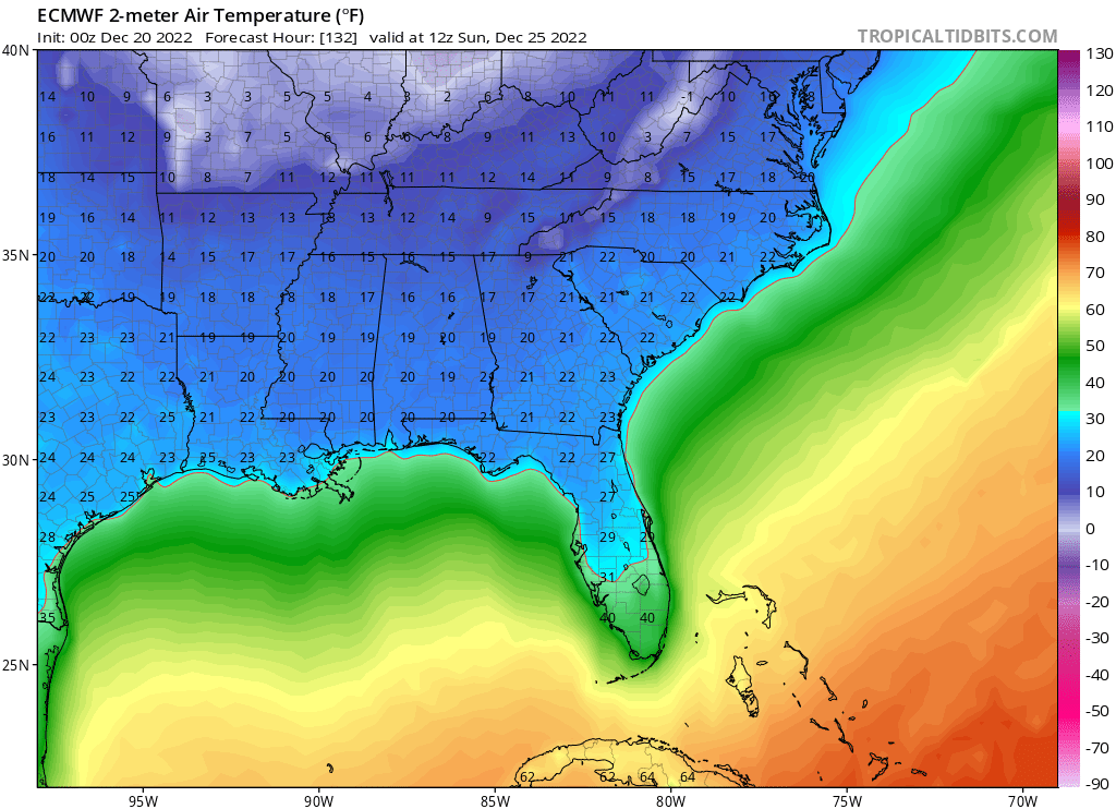
Here are the latest forecasted lows from the 12z MOS guidance for Friday, Saturday and Sunday nights.
Tallahassee: 19F, 21F, 27F
Jacksonville Int'l: 20F, 24F, 28F
Orlando Int'l: 33F, 32F, 39F
Tampa Int'l: 32F, 34F, 40F
Naples: 42F, 41F, 42F
West Palm: 43F, 40F, 48F
Miami Int'l: 45F, 47F, 54F
Tallahassee: 19F, 21F, 27F
Jacksonville Int'l: 20F, 24F, 28F
Orlando Int'l: 33F, 32F, 39F
Tampa Int'l: 32F, 34F, 40F
Naples: 42F, 41F, 42F
West Palm: 43F, 40F, 48F
Miami Int'l: 45F, 47F, 54F
2 likes


Re: Florida Weather
NWS Forecasted lows in South Florida on Friday night, Saturday night, and Sunday night as of 4:00 PM today:
42°F, 41°F, 43°F - KAPF - Naples Municipal Airport, Naples
40°F, 42°F, 47°F - KPBI - Palm Beach International Airport, West Palm Beach
44°F, 45°F, 49°F - KFXE - Fort Lauderdale Executive Airport, Fort Lauderdale
44°F, 45°F, 50°F - KFLL - Fort Lauderdale-Hollywood International Airport, Fort Lauderdale
44°F, 45°F, 50°F - KPMP - Pompano Beach Airpark, Pompano Beach
43°F, 42°F, 48°F - KHWO - North Perry Airport, Pembroke Pines
44°F, 44°F, 48°F - KOPF - Opa Locka Airport, Opa Locka
45°F, 45°F, 49°F - KMIA - Miami International Airport, Miami
44°F, 42°F, 46°F - KTMB - Kendall-Tamiami Executive Airport, West Kendall
45°F, 43°F, 48°F - KHST - Homestead Air Reserve Base, Homestead
The expected numbers dropped a lot over the day and in my area they're now forecasting 43°F, 43°F, and 46°F.
Highs are also expected to be abnormally low on Saturday and Sunday in the high 50s in my area
0 likes
-
tropicwatch

- Category 5

- Posts: 3205
- Age: 60
- Joined: Sat Jun 02, 2007 10:01 am
- Location: Panama City Florida
- Contact:
Re: Florida Weather
Kind of a rare situation, 50 degrees with thunderstorms in Panama City right now. When we get snow the upcoming setup is usually how it happens. Cold front comes through then moisture from low pressure in the Gulf of Mexico. Timing and position of the low will be the key.
1 likes
Tropicwatch
Agnes 72', Eloise 75, Elena 85', Kate 85', Charley 86', Florence 88', Beryl 94', Dean 95', Erin 95', Opal 95', Earl 98', Georges 98', Ivan 2004', Arlene 2005', Dennis 2005', Ida 2009' Debby 2012' Irma 2017' Michael 2018'
Agnes 72', Eloise 75, Elena 85', Kate 85', Charley 86', Florence 88', Beryl 94', Dean 95', Erin 95', Opal 95', Earl 98', Georges 98', Ivan 2004', Arlene 2005', Dennis 2005', Ida 2009' Debby 2012' Irma 2017' Michael 2018'
Re: Florida Weather
Nice to see the extended outlooks warming up. Looks like about 3 days and nights of cold...probably not cold enough for a damaging freeze locally but a close shave. Odds favor warmth for the new year.
3 likes
Re: Florida Weather
psyclone wrote:Nice to see the extended outlooks warming up. Looks like about 3 days and nights of cold...probably not cold enough for a damaging freeze locally but a close shave. Odds favor warmth for the new year.
We are lucky that the snow cover is lacking prior to this Arctic blast otherwise we would had seen temps much colder by least 5 degrees.
Edit:
Interesting that Miami hasn’t officially hit the freezing mark since 1989, prior to 1989 it recorded 4 freezes dating back to 1977. It was very common for Miami to hit the 30s just about every year prior to 1989. The last time Miami dropped down to the 30s was 2010.
1 likes
-
gatorcane
- S2K Supporter
- Posts: 23499
- Age: 46
- Joined: Sun Mar 13, 2005 3:54 pm
- Location: Boca Raton, FL
Re: Florida Weather
About as bullish as I have seen NWS Tampa for a significant cold air event. Usually they are conservative on the rhetoric but some strong words:
“The cold front will move over southern Florida by Friday afternoon
and temperatures will begin to drastically drop through the day and
into the night. Behind this major weather system, a strong 1050 mb
high pressure center moves from Canada into the central U.S. Strong
cold air advection on the back side of the major trough will push
into the southeast U.S. bringing one of the coldest polar air masses
that Florida has experienced so far this season and will bring some
of the coldest temperatures for the holiday weekend seen in many
years. Daytime highs on Saturday through Monday will top out only in
the 40`s and 50`s. The overnight lows Friday night through Sunday
night will drop into the 20`s and 30`s for most of west central and
southwest Florida. These daytime highs and overnight lows are around
15-25 degrees below average regionwide. It is too early at this time
to issue any type of cold weather watches or warnings, but
widespread freeze warnings, hard freeze warnings along the Nature
Coast and interior, as well as wind chill warnings or advisories and
frost advisories are likely over the holiday weekend. A slow warm up
will start on Monday night and Tuesday next week.”
https://forecast.weather.gov/product.ph ... hlight=off
3 likes
Re: Florida Weather
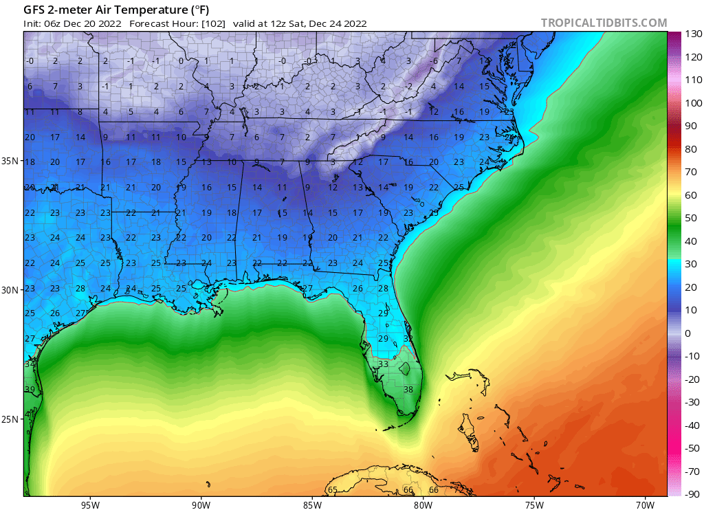
As usually the case the models' raw numbers have trended warmer as we get closer in time but MOS guidance continue to go down in most places. I still think forecasted lows for at least south FL are too cold because of the high cloud cover forecasted to move in.
Latest MOS forecasted lows for Saturday, Sunday and Monday mornings.
Tallahassee: 18F, 17F, 19F
Jacksonville Int'l: 21F, 20F, 27F
Orlando Int'l: 28F, 33F, 39F
Tampa Int'l: 31F, 35F, 39F
Naples: 41F, 42F, 47F
West Palm: 41F, 37F, 45F
Miami: 46F, 43F, 52F
Latest MOS forecasted lows for Saturday, Sunday and Monday mornings.
Tallahassee: 18F, 17F, 19F
Jacksonville Int'l: 21F, 20F, 27F
Orlando Int'l: 28F, 33F, 39F
Tampa Int'l: 31F, 35F, 39F
Naples: 41F, 42F, 47F
West Palm: 41F, 37F, 45F
Miami: 46F, 43F, 52F
1 likes
Re: Florida Weather
NDG wrote:As usually the case the models' raw numbers have trended warmer as we get closer in time but MOS guidance continue to go down in most places. I still think forecasted lows for at least south FL are too cold because of the high cloud cover forecasted to move in.
Latest MOS forecasted lows for Saturday, Sunday and Monday mornings.
Tallahassee: 18F, 17F, 19F
Jacksonville Int'l: 21F, 20F, 27F
Orlando Int'l: 28F, 33F, 39F
Tampa Int'l: 31F, 35F, 39F
Naples: 41F, 42F, 47F
West Palm: 41F, 37F, 45F
Miami: 46F, 43F, 52F
What does MOS mean?
Also why would cloud cover increase the temperature?
0 likes
Re: Florida Weather
Abdullah wrote:NDG wrote:As usually the case the models' raw numbers have trended warmer as we get closer in time but MOS guidance continue to go down in most places. I still think forecasted lows for at least south FL are too cold because of the high cloud cover forecasted to move in.
Latest MOS forecasted lows for Saturday, Sunday and Monday mornings.
Tallahassee: 18F, 17F, 19F
Jacksonville Int'l: 21F, 20F, 27F
Orlando Int'l: 28F, 33F, 39F
Tampa Int'l: 31F, 35F, 39F
Naples: 41F, 42F, 47F
West Palm: 41F, 37F, 45F
Miami: 46F, 43F, 52F
What does MOS mean?
Also why would cloud cover increase the temperature?
MOS stands for Model Output Statistics. It takes into considiration climatology and analogs, if I understand it correctly so that's why it differs from the models' raw numbers which many times are either too warm or too cold.
Cloud cover acts like a blanket and keeps the surface temperatures from dropping too much at night. The coldest nights in FL is when winds are near calm and the sky is clear. Radiational cooling.
1 likes

Re: Florida Weather
NDG wrote:Abdullah wrote:NDG wrote:As usually the case the models' raw numbers have trended warmer as we get closer in time but MOS guidance continue to go down in most places. I still think forecasted lows for at least south FL are too cold because of the high cloud cover forecasted to move in.
Latest MOS forecasted lows for Saturday, Sunday and Monday mornings.
Tallahassee: 18F, 17F, 19F
Jacksonville Int'l: 21F, 20F, 27F
Orlando Int'l: 28F, 33F, 39F
Tampa Int'l: 31F, 35F, 39F
Naples: 41F, 42F, 47F
West Palm: 41F, 37F, 45F
Miami: 46F, 43F, 52F
What does MOS mean?
Also why would cloud cover increase the temperature?
MOS stands for Model Output Statistics. It takes into considiration climatology and analogs, if I understand it correctly so that's why it differs from the models' raw numbers which many times are either too warm or too cold.
Cloud cover acts like a blanket and keeps the surface temperatures from dropping too much at night. The coldest nights in FL is when winds are near calm and the sky is clear. Radiational cooling.
I don’t think it will get below 50 here in SE Florida cold fronts aren’t the same as the were growing up here.
0 likes
Re: Florida Weather
NDG wrote:Abdullah wrote:NDG wrote:As usually the case the models' raw numbers have trended warmer as we get closer in time but MOS guidance continue to go down in most places. I still think forecasted lows for at least south FL are too cold because of the high cloud cover forecasted to move in.
Latest MOS forecasted lows for Saturday, Sunday and Monday mornings.
Tallahassee: 18F, 17F, 19F
Jacksonville Int'l: 21F, 20F, 27F
Orlando Int'l: 28F, 33F, 39F
Tampa Int'l: 31F, 35F, 39F
Naples: 41F, 42F, 47F
West Palm: 41F, 37F, 45F
Miami: 46F, 43F, 52F
What does MOS mean?
Also why would cloud cover increase the temperature?
MOS stands for Model Output Statistics. It takes into considiration climatology and analogs, if I understand it correctly so that's why it differs from the models' raw numbers which many times are either too warm or too cold.
Where can the public receive access to MOS? Could you link it? And who develops this? Is this like the GFS or ECMWF makes a secondary one called MOS?
Also, is it more accurate than raw model output?
0 likes
-
HurricaneBelle

- S2K Supporter
- Posts: 974
- Joined: Sun Aug 27, 2006 6:12 pm
- Location: Clearwater, FL
Re: Florida Weather
Abdullah wrote:Where can the public receive access to MOS? Could you link it? And who develops this? Is this like the GFS or ECMWF makes a secondary one called MOS?
Also, is it more accurate than raw model output?
You can get it for GFS from here: https://www.weather.gov/mdl/mos_getbull
Just need to type in the station you want the MOS for and which report you want (short-term or extended)
1 likes