SAL Map URL??

This is the general tropical discussion area. Anyone can take their shot at predicting a storms path.

Moderator: S2k Moderators

Forum rules

The posts in this forum are NOT official forecasts and should not be used as such. They are just the opinion of the poster and may or may not be backed by sound meteorological data. They are NOT endorsed by any professional institution or STORM2K. For official information, please refer to products from the National Hurricane Center and National Weather Service.

Help Support Storm2K
Message
Author
User avatar
wxman57
Moderator-Pro Met
Moderator-Pro Met
Posts: 22980
Age: 67
Joined: Sat Jun 21, 2003 8:06 pm
Location: Houston, TX (southwest)

SAL Map URL??

#1 Postby wxman57 » Tue Jul 10, 2012 7:56 am

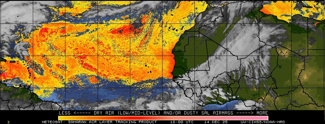
Perhaps someone here knows what happened to the SAL map that covered all the way through the Caribbean to the U.S.? All they have on their website now is a map that extends from Africa to the east Caribbean:

http://tropic.ssec.wisc.edu/real-time/s ... litE&time=

Image
0 likes   

USTropics
Professional-Met
Professional-Met
Posts: 2653
Joined: Sun Aug 12, 2007 3:45 am
Location: Florida State University

#2 Postby USTropics » Tue Jul 10, 2012 9:56 am

This was the link:

http://tropic.ssec.wisc.edu/real-time/sal/splitEW.jpg


After searching through their database it seems the product was last updated in December of 2011 and no new images have been produced since.
0 likes   

User avatar
SFLcane
S2K Supporter
S2K Supporter
Posts: 10163
Age: 47
Joined: Sat Jun 05, 2010 1:44 pm
Location: Lake Worth Florida

Re: SAL Map URL??

#3 Postby SFLcane » Tue Jul 10, 2012 10:12 am

The current GOES satellites no longer have one of the channels that are required to produce those products. CIMSS is limited to the coverage provided by the European MET-9 satellite.
0 likes   

User avatar
tailgater
S2K Supporter
S2K Supporter
Posts: 3339
Joined: Sun Jul 11, 2004 9:13 pm
Location: St. Amant La.

Re: SAL Map URL??

#4 Postby tailgater » Tue Jul 10, 2012 10:24 am

I think it went away when they deactivated GOES 11
0 likes   
The following post is NOT an official forecast and should not be used as such. It is just the opinion of the poster and may or may not be backed by sound meteorological data. It is NOT endorsed by any professional institution including storm2k.org For Official Information please refer to the NHC and NWS products.
HURRICANELONNY
Category 5
Category 5
Posts: 1383
Joined: Wed May 07, 2003 6:48 am
Location: HOLLYWOOD.FL

Re: SAL Map URL??

#5 Postby HURRICANELONNY » Mon Jul 23, 2012 5:00 pm

I have the SAL site and can't find any product that shows the Carribean.
http://tropic.ssec.wisc.edu/tropic.php

When I click on the Carribean. It shows the Atlantic. I guess your right. Goes 11 gone...
0 likes   
hurricanelonny


Return to “Talkin' Tropics”

Who is online

Users browsing this forum: Cpv17, Frank P, jaguars_22, TomballEd, USTropics and 66 guests