2024 Indicators: SST's, MSLP, Shear, SAL, Steering, Instability (Day 16+ Climate Models)

This is the general tropical discussion area. Anyone can take their shot at predicting a storms path.

Moderator: S2k Moderators

Forum rules

The posts in this forum are NOT official forecasts and should not be used as such. They are just the opinion of the poster and may or may not be backed by sound meteorological data. They are NOT endorsed by any professional institution or STORM2K. For official information, please refer to products from the National Hurricane Center and National Weather Service.

Help Support Storm2K
Message
Author
User avatar
toad strangler
S2K Supporter
S2K Supporter
Posts: 4172
Joined: Sun Jul 28, 2013 3:09 pm
Location: Earth
Contact:

Re: 2024 Indicators: SST's, MSLP, Shear, SAL, Steering, Instability (Day 16+ Climate Models)

#881 Postby toad strangler » Sun May 12, 2024 10:19 am

CFS showing the early June action being whispered about around the vast wx campus

Image
Image
0 likes   

MarioProtVI
Category 2
Category 2
Posts: 671
Age: 22
Joined: Sun Sep 29, 2019 7:33 pm
Location: New Jersey

Re: 2024 Indicators: SST's, MSLP, Shear, SAL, Steering, Instability (Day 16+ Climate Models)

#882 Postby MarioProtVI » Sun May 12, 2024 3:37 pm

DorkyMcDorkface wrote:Interesting to see the Atlantic Niño (and much of the South Atlantic north of 20S in general) cool off quite a bit as of late. Wondering if this could be heralding a more +AMM configuration once again. Remember last month much of the seasonal guidance adjusted to show a prominent Atlantic Niño/warmer SATL but for this month they've backed off on that idea slightly.
https://i.ibb.co/bQqVPyD/bda2f579-bbee-46d2-b13e-6e1d6654b395.gif
https://i.ibb.co/6sGfz58/crw-ssta-change-satl.png

Didn’t 2020 have an Atlantic Niña? I think that was one of the reasons that the MDR did poorly sans Teddy to everyone’s expectations - since the Nina forced the ITCZ further north leading to waves coming off further north and developing into weaker TCs because of cooler waters and drier air. Versus 2021 where the suppressed ITCZ due to the Atlantic Nino resulted in a very active MDR with several hurricanes and a few majors because the waves were able to come off further south and insulated from the cool SSTs and dry air.

If 2024 is developing an Atlantic Niña as it seems it might be from that loop, I think expectations will have to be tempered down a bit due to a more stable MDR (which as of right now seems to be where most predictions think the bulk of the high activity and numbers will originate from).
1 likes   

User avatar
tiger_deF
Category 1
Category 1
Posts: 440
Age: 23
Joined: Tue Sep 27, 2016 11:47 am

Re: 2024 Indicators: SST's, MSLP, Shear, SAL, Steering, Instability (Day 16+ Climate Models)

#883 Postby tiger_deF » Sun May 12, 2024 3:56 pm

https://imgur.com/a/eonuFhZ

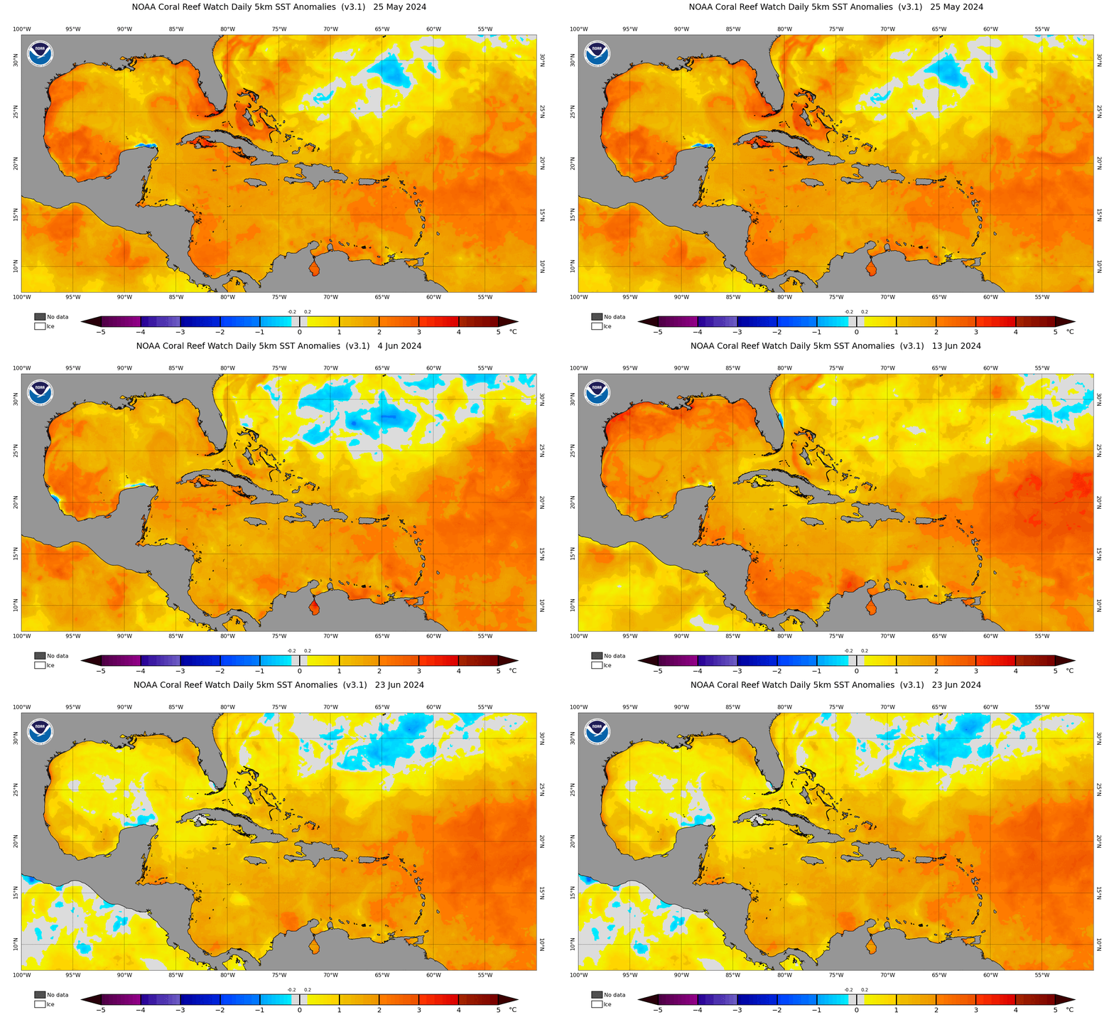
Despite the SATL cooling, the anomalies in the MDR are actually increasing. Huge swatch of 2-3+ Celsius anomalies across the entire tropical Atlantic. Gulf is also warming up considerably. Hard to look at this and not think hyperactive.
2 likes   

User avatar
DorkyMcDorkface
Category 2
Category 2
Posts: 721
Age: 26
Joined: Mon Sep 30, 2019 1:32 pm
Location: Mid-Atlantic

Re: 2024 Indicators: SST's, MSLP, Shear, SAL, Steering, Instability (Day 16+ Climate Models)

#884 Postby DorkyMcDorkface » Sun May 12, 2024 3:58 pm

MarioProtVI wrote:
DorkyMcDorkface wrote:Interesting to see the Atlantic Niño (and much of the South Atlantic north of 20S in general) cool off quite a bit as of late. Wondering if this could be heralding a more +AMM configuration once again. Remember last month much of the seasonal guidance adjusted to show a prominent Atlantic Niño/warmer SATL but for this month they've backed off on that idea slightly.
https://i.ibb.co/bQqVPyD/bda2f579-bbee-46d2-b13e-6e1d6654b395.gif
https://i.ibb.co/6sGfz58/crw-ssta-change-satl.png

Didn’t 2020 have an Atlantic Niña? I think that was one of the reasons that the MDR did poorly sans Teddy to everyone’s expectations - since the Nina forced the ITCZ further north leading to waves coming off further north and developing into weaker TCs because of cooler waters and drier air. Versus 2021 where the suppressed ITCZ due to the Atlantic Nino resulted in a very active MDR with several hurricanes and a few majors because the waves were able to come off further south and insulated from the cool SSTs and dry air.

If 2024 is developing an Atlantic Niña as it seems it might be from that loop, I think expectations will have to be tempered down a bit due to a more stable MDR (which as of right now seems to be where most predictions think the bulk of the high activity and numbers will originate from).


2020 didn't have a record warm MDR/+AMO. That alone will help focus instability in the MDR for the most part, as long as the subtropics don't warm up considerably as well (which is what happened as 2020 progressed that lead to some of the stability issues we saw).
2 likes   
Floyd 1999 | Isabel 2003 | Hanna 2008 | Irene 2011 | Sandy 2012 | Isaias 2020

User avatar
skyline385
Category 5
Category 5
Posts: 2503
Age: 33
Joined: Wed Aug 26, 2020 11:15 pm
Location: Houston TX

Re: 2024 Indicators: SST's, MSLP, Shear, SAL, Steering, Instability (Day 16+ Climate Models)

#885 Postby skyline385 » Sun May 12, 2024 4:18 pm

DorkyMcDorkface wrote:
MarioProtVI wrote:
DorkyMcDorkface wrote:Interesting to see the Atlantic Niño (and much of the South Atlantic north of 20S in general) cool off quite a bit as of late. Wondering if this could be heralding a more +AMM configuration once again. Remember last month much of the seasonal guidance adjusted to show a prominent Atlantic Niño/warmer SATL but for this month they've backed off on that idea slightly.
https://i.ibb.co/bQqVPyD/bda2f579-bbee-46d2-b13e-6e1d6654b395.gif
https://i.ibb.co/6sGfz58/crw-ssta-change-satl.png

Didn’t 2020 have an Atlantic Niña? I think that was one of the reasons that the MDR did poorly sans Teddy to everyone’s expectations - since the Nina forced the ITCZ further north leading to waves coming off further north and developing into weaker TCs because of cooler waters and drier air. Versus 2021 where the suppressed ITCZ due to the Atlantic Nino resulted in a very active MDR with several hurricanes and a few majors because the waves were able to come off further south and insulated from the cool SSTs and dry air.

If 2024 is developing an Atlantic Niña as it seems it might be from that loop, I think expectations will have to be tempered down a bit due to a more stable MDR (which as of right now seems to be where most predictions think the bulk of the high activity and numbers will originate from).


2020 didn't have a record warm MDR/+AMO. That alone will help focus instability in the MDR for the most part, as long as the subtropics don't warm up considerably as well (which is what happened as 2020 progressed that lead to some of the stability issues we saw).


2020 also had that problem of monsoonal gyres being dumped into the NATL which would result in vortmaxes fighting with each other until they got to the Caribbean or forever (like Isaias) as well as some big SAL outbreaks.
1 likes   

User avatar
Category5Kaiju
Category 5
Category 5
Posts: 3404
Age: 22
Joined: Thu Dec 24, 2020 12:45 pm
Location: Seattle

Re: 2024 Indicators: SST's, MSLP, Shear, SAL, Steering, Instability (Day 16+ Climate Models)

#886 Postby Category5Kaiju » Sun May 12, 2024 5:20 pm

MarioProtVI wrote:
DorkyMcDorkface wrote:Interesting to see the Atlantic Niño (and much of the South Atlantic north of 20S in general) cool off quite a bit as of late. Wondering if this could be heralding a more +AMM configuration once again. Remember last month much of the seasonal guidance adjusted to show a prominent Atlantic Niño/warmer SATL but for this month they've backed off on that idea slightly.
https://i.ibb.co/bQqVPyD/bda2f579-bbee-46d2-b13e-6e1d6654b395.gif
https://i.ibb.co/6sGfz58/crw-ssta-change-satl.png

Didn’t 2020 have an Atlantic Niña? I think that was one of the reasons that the MDR did poorly sans Teddy to everyone’s expectations - since the Nina forced the ITCZ further north leading to waves coming off further north and developing into weaker TCs because of cooler waters and drier air. Versus 2021 where the suppressed ITCZ due to the Atlantic Nino resulted in a very active MDR with several hurricanes and a few majors because the waves were able to come off further south and insulated from the cool SSTs and dry air.

If 2024 is developing an Atlantic Niña as it seems it might be from that loop, I think expectations will have to be tempered down a bit due to a more stable MDR (which as of right now seems to be where most predictions think the bulk of the high activity and numbers will originate from).


Also important to keep in mind that a strong Atlantic Nino, as we saw back in 2021, can be a negative factor for late season activity as it drags instability southward.

Aside from that, I'm not entirely convinced by the argument that Atlantic Nino alone is necessary for heightened MDR activity, especially with an extremely potent +AMO already in place. I mean yeah sure it might very well indeed play a beneficial role in increasing MDR activity like we saw 3 years ago, but we've seen years (2010 and 2017 as examples) that lacked a defined Atlantic Nino during peak season, yet saw many powerful MDR systems.
1 likes   
Unless explicitly stated, all information covered in my posts is based on my opinions and observations. Please refer to a professional meteorologist or an accredited weather research agency otherwise, especially if serious decisions must be made in the event of a potentially life-threatening tropical storm or hurricane.

User avatar
skyline385
Category 5
Category 5
Posts: 2503
Age: 33
Joined: Wed Aug 26, 2020 11:15 pm
Location: Houston TX

Re: 2024 Indicators: SST's, MSLP, Shear, SAL, Steering, Instability (Day 16+ Climate Models)

#887 Postby skyline385 » Sun May 12, 2024 7:04 pm

Category5Kaiju wrote:
MarioProtVI wrote:
DorkyMcDorkface wrote:Interesting to see the Atlantic Niño (and much of the South Atlantic north of 20S in general) cool off quite a bit as of late. Wondering if this could be heralding a more +AMM configuration once again. Remember last month much of the seasonal guidance adjusted to show a prominent Atlantic Niño/warmer SATL but for this month they've backed off on that idea slightly.
https://i.ibb.co/bQqVPyD/bda2f579-bbee-46d2-b13e-6e1d6654b395.gif
https://i.ibb.co/6sGfz58/crw-ssta-change-satl.png

Didn’t 2020 have an Atlantic Niña? I think that was one of the reasons that the MDR did poorly sans Teddy to everyone’s expectations - since the Nina forced the ITCZ further north leading to waves coming off further north and developing into weaker TCs because of cooler waters and drier air. Versus 2021 where the suppressed ITCZ due to the Atlantic Nino resulted in a very active MDR with several hurricanes and a few majors because the waves were able to come off further south and insulated from the cool SSTs and dry air.

If 2024 is developing an Atlantic Niña as it seems it might be from that loop, I think expectations will have to be tempered down a bit due to a more stable MDR (which as of right now seems to be where most predictions think the bulk of the high activity and numbers will originate from).


Also important to keep in mind that a strong Atlantic Nino, as we saw back in 2021, can be a negative factor for late season activity as it drags instability southward.

Aside from that, I'm not entirely convinced by the argument that Atlantic Nino alone is necessary for heightened MDR activity, especially with an extremely potent +AMO already in place. I mean yeah sure it might very well indeed play a beneficial role in increasing MDR activity like we saw 3 years ago, but we've seen years (2010 and 2017 as examples) that lacked a defined Atlantic Nino during peak season, yet saw many powerful MDR systems.


On that topic, the effects of the Atlantic Nina/Nino are still being researched and there just aren't that many studies on it from what I have seen. Also, several active years had an Atlantic Nina in June/July which started decaying as we got into August/September. Here are 2004 & 2005 for example:

Image
Image
1 likes   

User avatar
Teban54
Category 5
Category 5
Posts: 1974
Joined: Sat May 19, 2018 1:19 pm

Re: 2024 Indicators: SST's, MSLP, Shear, SAL, Steering, Instability (Day 16+ Climate Models)

#888 Postby Teban54 » Sun May 12, 2024 8:30 pm

skyline385 wrote:
Category5Kaiju wrote:
MarioProtVI wrote:Didn’t 2020 have an Atlantic Niña? I think that was one of the reasons that the MDR did poorly sans Teddy to everyone’s expectations - since the Nina forced the ITCZ further north leading to waves coming off further north and developing into weaker TCs because of cooler waters and drier air. Versus 2021 where the suppressed ITCZ due to the Atlantic Nino resulted in a very active MDR with several hurricanes and a few majors because the waves were able to come off further south and insulated from the cool SSTs and dry air.

If 2024 is developing an Atlantic Niña as it seems it might be from that loop, I think expectations will have to be tempered down a bit due to a more stable MDR (which as of right now seems to be where most predictions think the bulk of the high activity and numbers will originate from).


Also important to keep in mind that a strong Atlantic Nino, as we saw back in 2021, can be a negative factor for late season activity as it drags instability southward.

Aside from that, I'm not entirely convinced by the argument that Atlantic Nino alone is necessary for heightened MDR activity, especially with an extremely potent +AMO already in place. I mean yeah sure it might very well indeed play a beneficial role in increasing MDR activity like we saw 3 years ago, but we've seen years (2010 and 2017 as examples) that lacked a defined Atlantic Nino during peak season, yet saw many powerful MDR systems.


On that topic, the effects of the Atlantic Nina/Nino are still being researched and there just aren't that many studies on it from what I have seen. Also, several active years had an Atlantic Nina in June/July which started decaying as we got into August/September. Here are 2004 & 2005 for example:

[url]https://i.ibb.co/yPt24c0/image.png [/url]
[url]https://i.ibb.co/tDcs6V4/image.png [/url]

USTropics did an exhaustive analysis of Atlantic Nino years in 2021. I can't find it easily now, but I remember in one of the 4 broad categories of years with an early Atlantic Nino in spring and summer, the anomalous warmth is actually transferred north towards the MDR later in fall. This may be one of the reasons why Atlantic Ninos seem to be beneficial for the hurricane season overall based on preliminary studies.

(It should be noted that the inverse, "no Atlantic Nino means less activity" which Mario seems to be basing his comment on, has even less evidence AFAIK and doesn't seem to be anything other than a logical fallacy.)
2 likes   

User avatar
WiscoWx02
Category 1
Category 1
Posts: 341
Age: 21
Joined: Sat Jul 31, 2021 8:09 pm
Location: Minnesota

Re: 2024 Indicators: SST's, MSLP, Shear, SAL, Steering, Instability (Day 16+ Climate Models)

#889 Postby WiscoWx02 » Sun May 12, 2024 11:04 pm

The Atlantic Nino is certainly something I would love to know more about and how it impacts the hurricane season, but I am also curious if the PMM and PDO are known to impact steering patterns for the Atlantic during the hurricane season...looking back at the last 25 years it seems a -PMM is more frequent than not, and many big impact years has a -PMM while the PDO was all over the place so highly doubt there is a correlation there, but I am wondering if there is anyone who may know more about it?
0 likes   

User avatar
ScottNAtlanta
Category 5
Category 5
Posts: 2006
Joined: Sat May 25, 2013 3:11 pm
Location: Atlanta, GA

Re: 2024 Indicators: SST's, MSLP, Shear, SAL, Steering, Instability (Day 16+ Climate Models)

#890 Postby ScottNAtlanta » Mon May 13, 2024 10:36 am

Take a look at the last month how the loop current sent an eddy to the north. Don't know that I have seen that before

Image
3 likes   
The posts in this forum are NOT official forecast and should not be used as such. They are just the opinion of the poster and may or may not be backed by sound meteorological data. They are NOT endorsed by any professional institution or storm2k.org. For official information, please refer to the NHC and NWS products.

User avatar
Hurricane2022
Category 4
Category 4
Posts: 945
Joined: Tue Aug 23, 2022 11:38 pm
Location: Araçatuba, Brazil

Re: 2024 Indicators: SST's, MSLP, Shear, SAL, Steering, Instability (Day 16+ Climate Models)

#891 Postby Hurricane2022 » Mon May 13, 2024 1:07 pm

Image
Image
0 likes   
Sorry for the bad English sometimes...!
For reliable and detailed information for any meteorological phenomenon, please consult the National Hurricane Center, Joint Typhoon Warning Center , or your local Meteo Center.

--------

Una cvm Christo, pro Christo, et in Christo. Sit nomen Domini benedictvm.

User avatar
cycloneye
Admin
Admin
Posts: 139339
Age: 67
Joined: Thu Oct 10, 2002 10:54 am
Location: San Juan, Puerto Rico

Re: 2024 Indicators: SST's, MSLP, Shear, SAL, Steering, Instability (Day 16+ Climate Models)

#892 Postby cycloneye » Mon May 13, 2024 1:50 pm

0 likes   
Visit the Caribbean-Central America Weather Thread where you can find at first post web cams,radars
and observations from Caribbean basin members Click Here

User avatar
Blown Away
S2K Supporter
S2K Supporter
Posts: 9867
Joined: Wed May 26, 2004 6:17 am

Re: 2024 Indicators: SST's, MSLP, Shear, SAL, Steering, Instability (Day 16+ Climate Models)

#893 Postby Blown Away » Tue May 14, 2024 7:15 am

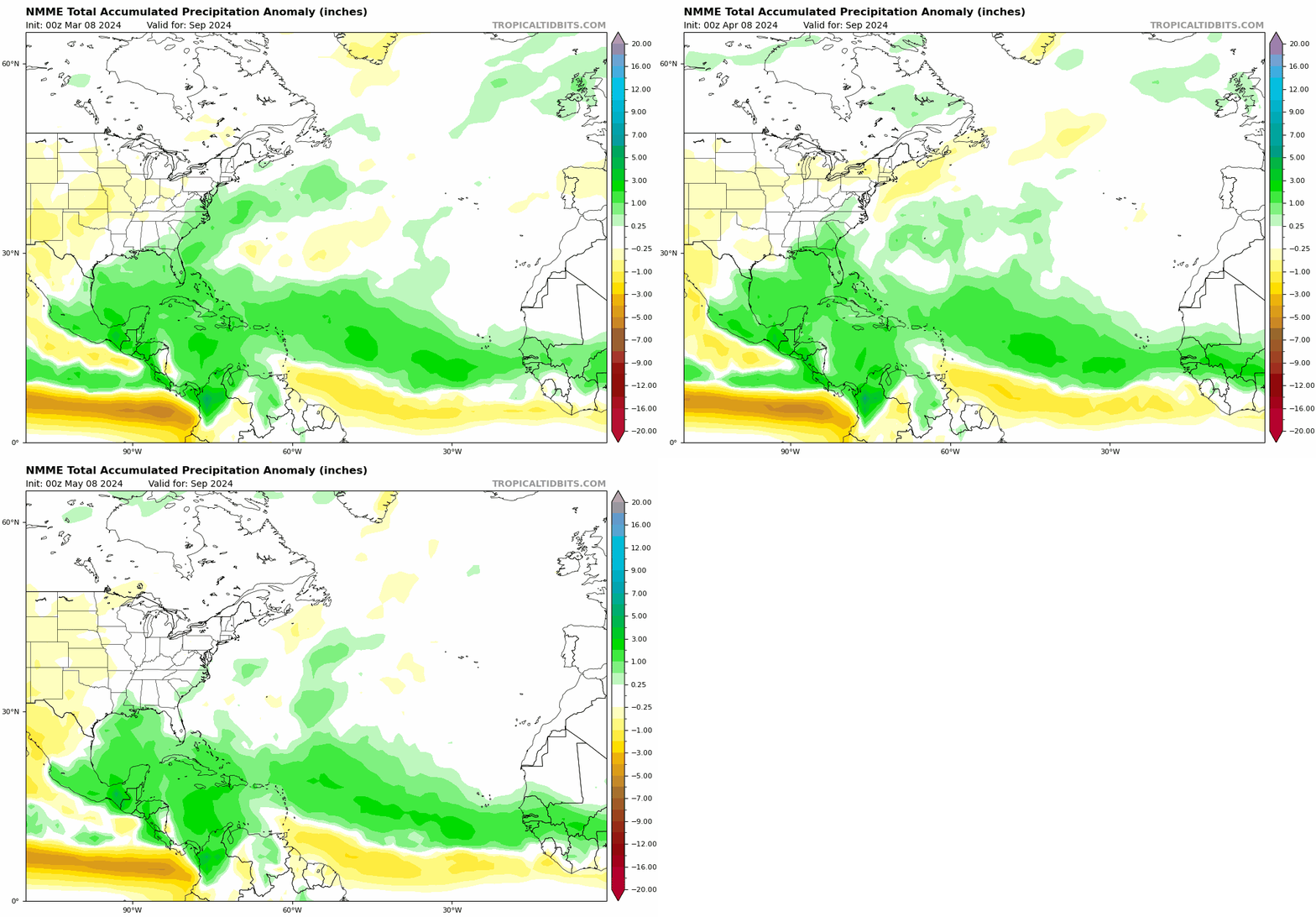
Image
September NMME Trend...

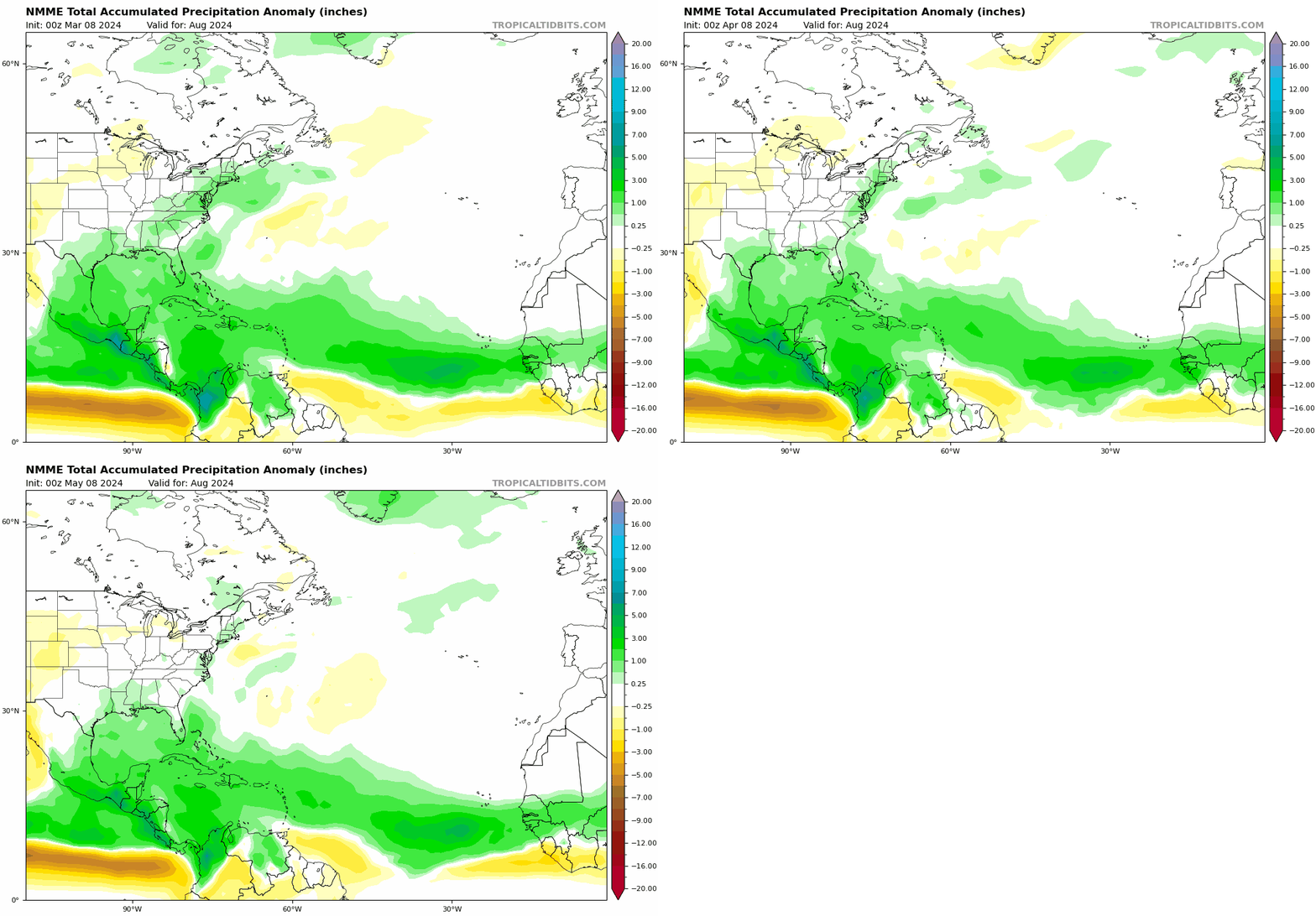
Image
August NMME Trend...

Both Aug/Sept trending drier along the NE CONUS, would that indicate the modeling seeing stronger HP and weaker East Coast Troughing?
0 likes   
Hurricane Eye Experience: David 79, Irene 99, Frances 04, Jeanne 04, Wilma 05... EYE COMING MY WAY IN 2024…
Hurricane Brush Experience: Andrew 92, Erin 95, Floyd 99, Matthew 16, Irma 17, Ian 22, Nicole 22…

User avatar
skyline385
Category 5
Category 5
Posts: 2503
Age: 33
Joined: Wed Aug 26, 2020 11:15 pm
Location: Houston TX

Re: 2024 Indicators: SST's, MSLP, Shear, SAL, Steering, Instability (Day 16+ Climate Models)

#894 Postby skyline385 » Tue May 14, 2024 8:07 am

Blown Away wrote:[url]https://i.postimg.cc/Ss8xVtDQ/42fd2c4b-7b14-42c1-b334-2ae733c6d03d.gif [/url]
September NMME Trend...

[url]https://i.postimg.cc/6q5FT82s/nmme-apcpna-month-nmme-atl-fh3-trend-1.gif [/url]
August NMME Trend...

Both Aug/Sept trending drier along the NE CONUS, would that indicate the modeling seeing stronger HP and weaker East Coast Troughing?


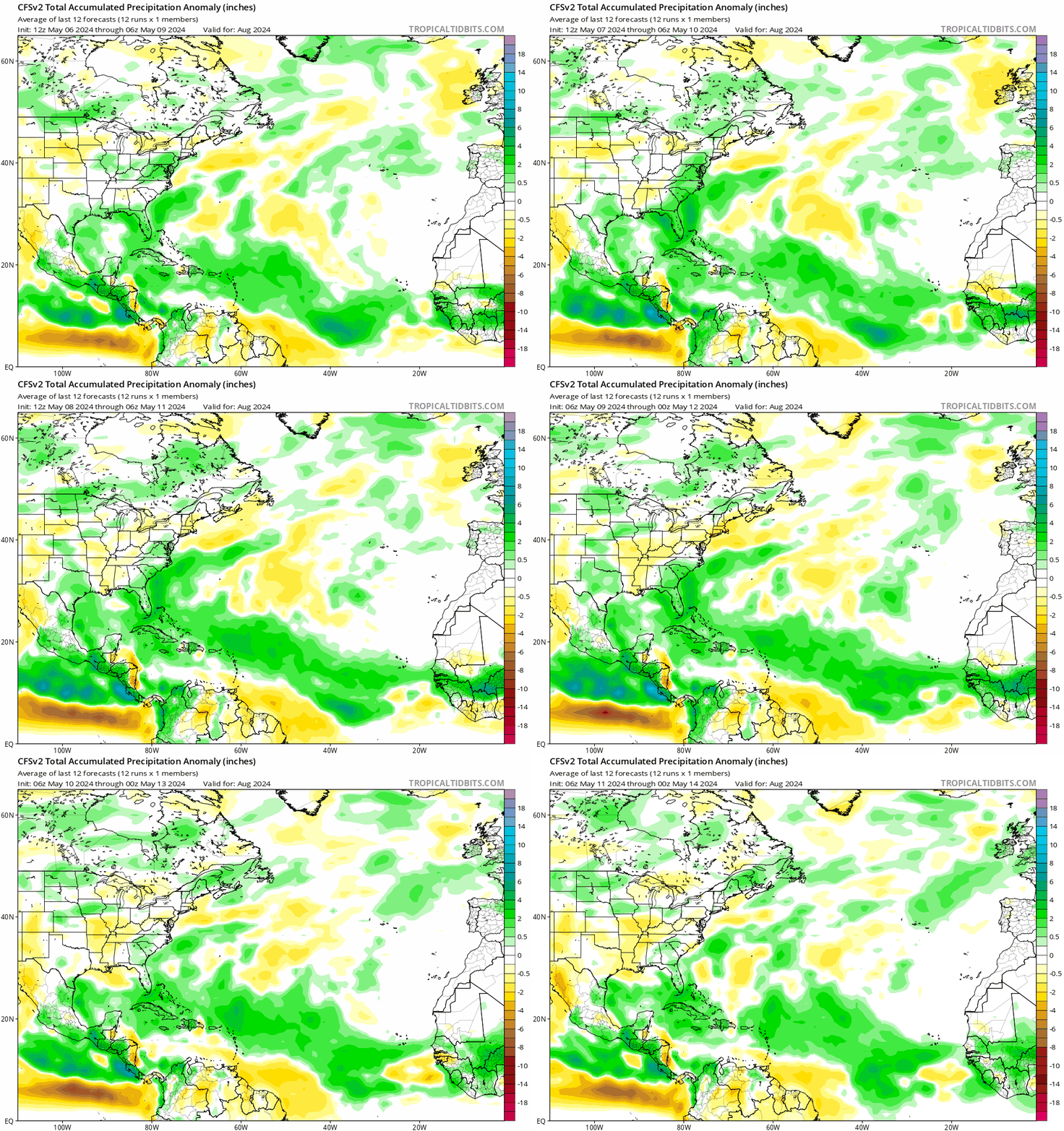
Funny thing is, I was just looking at 20 run trends of CFS yesterday and it has been doing kinda the opposite (atleast for August). You can see the GoM trending slightly drier and the MDR anomalies lifting north very slowly.

Image
0 likes   

User avatar
cycloneye
Admin
Admin
Posts: 139339
Age: 67
Joined: Thu Oct 10, 2002 10:54 am
Location: San Juan, Puerto Rico

Re: 2024 Indicators: SST's, MSLP, Shear, SAL, Steering, Instability (Day 16+ Climate Models)

#895 Postby cycloneye » Tue May 14, 2024 11:10 am

SST comparisons of 2024 with 2005, 2010 and 2020.

 https://twitter.com/AndyHazelton/status/1790413462281007502


1 likes   
Visit the Caribbean-Central America Weather Thread where you can find at first post web cams,radars
and observations from Caribbean basin members Click Here

Cpv17
Category 5
Category 5
Posts: 4386
Joined: Wed Dec 07, 2016 2:24 pm
Location: Wharton/El Campo, TX

Re: 2024 Indicators: SST's, MSLP, Shear, SAL, Steering, Instability (Day 16+ Climate Models)

#896 Postby Cpv17 » Tue May 14, 2024 11:24 am

skyline385 wrote:
Blown Away wrote:[url]https://i.postimg.cc/Ss8xVtDQ/42fd2c4b-7b14-42c1-b334-2ae733c6d03d.gif [/url]
September NMME Trend...

[url]https://i.postimg.cc/6q5FT82s/nmme-apcpna-month-nmme-atl-fh3-trend-1.gif [/url]
August NMME Trend...

Both Aug/Sept trending drier along the NE CONUS, would that indicate the modeling seeing stronger HP and weaker East Coast Troughing?


Funny thing is, I was just looking at 20 run trends of CFS yesterday and it has been doing kinda the opposite (atleast for August). You can see the GoM trending slightly drier and the MDR anomalies lifting north very slowly.

[url]https://i.postimg.cc/Qx8Y6YYB/2e90b800-d4ea-493b-9711-27d66a2aa843.gif [/url]


That model seems to be an outlier.
0 likes   

zzzh
Category 2
Category 2
Posts: 547
Joined: Thu Sep 02, 2021 1:13 pm

Re: 2024 Indicators: SST's, MSLP, Shear, SAL, Steering, Instability (Day 16+ Climate Models)

#897 Postby zzzh » Tue May 14, 2024 11:28 am

 https://twitter.com/DrKimWood/status/1790393146440036499


Image
Insane. Caribbean SST is nearly 4 month ahead of climo :eek: , and just need 0.1°C warmer to reach climo max of 29.1°C. I think it's safe to say that 2024 will break 2023's old record of 30.5°C by September.
0 likes   

Cpv17
Category 5
Category 5
Posts: 4386
Joined: Wed Dec 07, 2016 2:24 pm
Location: Wharton/El Campo, TX

Re: 2024 Indicators: SST's, MSLP, Shear, SAL, Steering, Instability (Day 16+ Climate Models)

#898 Postby Cpv17 » Tue May 14, 2024 11:53 am

zzzh wrote:https://twitter.com/DrKimWood/status/1790393146440036499
https://i.imgur.com/RFSEcyu.png
Insane. Caribbean SST is nearly 4 month ahead of climo :eek: , and just need 0.1°C warmer to reach climo max of 29.1°C. I think it's safe to say that 2024 will break 2023's old record of 30.5°C by September.


Maybe not if there’s a lot of upwelling.
2 likes   

User avatar
cycloneye
Admin
Admin
Posts: 139339
Age: 67
Joined: Thu Oct 10, 2002 10:54 am
Location: San Juan, Puerto Rico

Re: 2024 Indicators: SST's, MSLP, Shear, SAL, Steering, Instability (Day 16+ Climate Models)

#899 Postby cycloneye » Tue May 14, 2024 12:34 pm

0 likes   
Visit the Caribbean-Central America Weather Thread where you can find at first post web cams,radars
and observations from Caribbean basin members Click Here

User avatar
skyline385
Category 5
Category 5
Posts: 2503
Age: 33
Joined: Wed Aug 26, 2020 11:15 pm
Location: Houston TX

Re: 2024 Indicators: SST's, MSLP, Shear, SAL, Steering, Instability (Day 16+ Climate Models)

#900 Postby skyline385 » Tue May 14, 2024 1:15 pm

Cpv17 wrote:
zzzh wrote:https://twitter.com/DrKimWood/status/1790393146440036499
https://i.imgur.com/RFSEcyu.png
Insane. Caribbean SST is nearly 4 month ahead of climo :eek: , and just need 0.1°C warmer to reach climo max of 29.1°C. I think it's safe to say that 2024 will break 2023's old record of 30.5°C by September.


Maybe not if there’s a lot of upwelling.


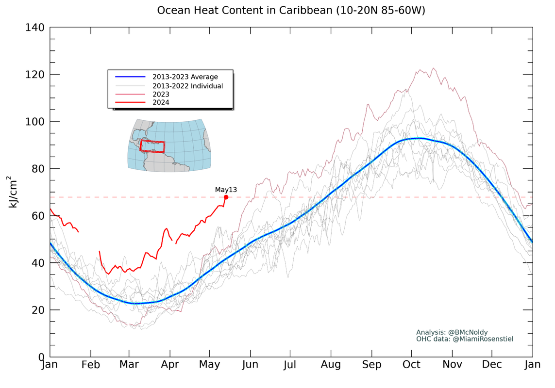
Well Caribbean OHC is also running 3 months ahead, upwelling isn't going to be very effective when there is so much warmth below the surface

Image
Last edited by skyline385 on Tue May 14, 2024 3:52 pm, edited 1 time in total.
7 likes   


Return to “Talkin' Tropics”

Who is online

Users browsing this forum: canes92, Chris90, Cpv17, Hurricane2022, kevin, SteveM, Stratton23 and 39 guests