2024 Indicators: SST's, MSLP, Shear, SAL, Steering, Instability (Day 16+ Climate Models)
Moderator: S2k Moderators
Forum rules

The posts in this forum are NOT official forecasts and should not be used as such. They are just the opinion of the poster and may or may not be backed by sound meteorological data. They are NOT endorsed by any professional institution or STORM2K. For official information, please refer to products from the National Hurricane Center and National Weather Service.
-
weeniepatrol

- Category 3

- Posts: 870
- Joined: Sat Aug 22, 2020 5:30 pm
- Location: WA State
Re: 2024 Indicators: SST's, MSLP, Shear, SAL, Steering, Instability (Day 16+ Climate Models)
Ya especially West Caribbean. Nothing to upwell but more warm water
2 likes

Re: 2024 Indicators: SST's, MSLP, Shear, SAL, Steering, Instability (Day 16+ Climate Models)
weeniepatrol wrote:Ya especially West Caribbean. Nothing to upwell but more warm water
I feel like the western Caribbean is like that every year. Seems like it always has the most OHC.
0 likes
-
skyline385

- Category 5

- Posts: 2545
- Age: 33
- Joined: Wed Aug 26, 2020 11:15 pm
- Location: Houston TX
Re: 2024 Indicators: SST's, MSLP, Shear, SAL, Steering, Instability (Day 16+ Climate Models)
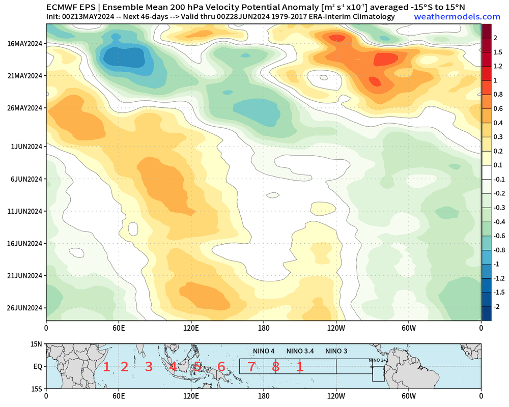
Extended EPS starting to show more signals as the MJO almost parks itself over the NATL although the potential for an EPAC system instead based on climo always remains.
0 likes
-
Deshaunrob17
- Tropical Storm

- Posts: 191
- Joined: Tue Aug 18, 2020 7:49 am
Re: 2024 Indicators: SST's, MSLP, Shear, SAL, Steering, Instability (Day 16+ Climate Models)
What’s impressive to me is how unusually wet it has been in the NE Caribbean . Several instances of significant flooding in the traditionally dry season. Even more impressive is , El Niño dry seasons usually mean drought in this part of this part of Caribbean. I won’t be surprised if the record ocean temperatures is a major cause of this. It shows the power of the very warm
Ocean temperatures and why the region needs to prepare for the upcoming Hurricane/ Wet Season.
Ocean temperatures and why the region needs to prepare for the upcoming Hurricane/ Wet Season.
1 likes
-
DorkyMcDorkface

- Category 2

- Posts: 732
- Age: 26
- Joined: Mon Sep 30, 2019 1:32 pm
- Location: Mid-Atlantic
Re: 2024 Indicators: SST's, MSLP, Shear, SAL, Steering, Instability (Day 16+ Climate Models)
0 likes
Floyd 1999 | Isabel 2003 | Hanna 2008 | Irene 2011 | Sandy 2012 | Isaias 2020


-
WeatherBoy2000
- Tropical Depression

- Posts: 97
- Joined: Mon Apr 10, 2023 9:29 am
Re: 2024 Indicators: SST's, MSLP, Shear, SAL, Steering, Instability (Day 16+ Climate Models)
DorkyMcDorkface wrote:https://twitter.com/dmorris9661/status/1790699086087176236?t=TIwt67v4ERLbJDWv3wwgkQ&s=19
Interestingly, if we don't see any activity beyond the first week of June it would make 2024 the latest starting season since 2014. Of course something might quickly spin up in the meantime, but atm there's nothing to indicate any May activity.
1 likes
-
cycloneye

- Admin

- Posts: 139527
- Age: 67
- Joined: Thu Oct 10, 2002 10:54 am
- Location: San Juan, Puerto Rico
Re: 2024 Indicators: SST's, MSLP, Shear, SAL, Steering, Instability (Day 16+ Climate Models)
Atlantic MDR very warm compared to the rest of the global tropics.

1 likes
Visit the Caribbean-Central America Weather Thread where you can find at first post web cams,radars
and observations from Caribbean basin members Click Here
and observations from Caribbean basin members Click Here

Re: 2024 Indicators: SST's, MSLP, Shear, SAL, Steering, Instability (Day 16+ Climate Models)
WeatherBoy2000 wrote:DorkyMcDorkface wrote:https://twitter.com/dmorris9661/status/1790699086087176236?t=TIwt67v4ERLbJDWv3wwgkQ&s=19
Interestingly, if we don't see any activity beyond the first week of June it would make 2024 the latest starting season since 2014. Of course something might quickly spin up in the meantime, but atm there's nothing to indicate any May activity.
In the "for what it's worth" column, while taking a look at the top 10 ACE producing Atlantic hurricane season years - 8 of 10 seasons had the first named storm after June 1.
6 likes
Personal Forecast Disclaimer:
The posts in this forum are NOT official forecast and should not be used as such. They are just the opinion of the poster and may or may not be backed by sound meteorological data. They are NOT endorsed by any professional institution or storm2k.org. For official information, please refer to the NHC and NWS products.
The posts in this forum are NOT official forecast and should not be used as such. They are just the opinion of the poster and may or may not be backed by sound meteorological data. They are NOT endorsed by any professional institution or storm2k.org. For official information, please refer to the NHC and NWS products.
-
skyline385
- Category 5
- Posts: 2545
- Age: 33
- Joined: Wed Aug 26, 2020 11:15 pm
- Location: Houston TX
Re: 2024 Indicators: SST's, MSLP, Shear, SAL, Steering, Instability (Day 16+ Climate Models)
WeatherBoy2000 wrote:DorkyMcDorkface wrote:https://twitter.com/dmorris9661/status/1790699086087176236?t=TIwt67v4ERLbJDWv3wwgkQ&s=19
Interestingly, if we don't see any activity beyond the first week of June it would make 2024 the latest starting season since 2014. Of course something might quickly spin up in the meantime, but atm there's nothing to indicate any May activity.
Some of the most hyperactive seasons typically have had June or even later starts. It's very likely because of the cooler sub-tropics which set up for the classical +AMO config (2004, 2005, 2008, 2010) preventing random spin-ups near the coast, generally responsible for early season starts. The same cooler sub-tropics then provide a more favorable environment in regards to instability over the MDR once the season gets going.
3 likes
Re: 2024 Indicators: SST's, MSLP, Shear, SAL, Steering, Instability (Day 16+ Climate Models)
Speaking of near-term conditions for potential cyclone development -

000
ABNT20 KNHC 151127
TWOAT
Tropical Weather Outlook
NWS National Hurricane Center Miami FL
800 AM EDT Wed May 15 2024
For the North Atlantic...Caribbean Sea and the Gulf of Mexico:
Tropical cyclone formation is not expected during the next 7 days.
&&
Today, May 15th, marks the first day of routine issuance of the
Atlantic basin Tropical Weather Outlook in 2024. This product
describes significant areas of disturbed weather and their
potential for tropical cyclone formation during the next seven
days. The Tropical Weather Outlook is issued from May 15 through
November 30 each year. The issuance times of this product are 2 AM,
8 AM, 2 PM, and 8 PM EDT. After the change to standard time in
November, the issuance times are 1 AM, 7 AM, 1 PM, and 7 PM EST.
A Special Tropical Weather Outlook will be issued to provide
updates, as necessary, in between the regularly scheduled issuances
of the Tropical Weather Outlook. Special Tropical Weather Outlooks
will be issued under the same WMO and AWIPS headers as the regular
Tropical Weather Outlooks.
A graphical version of the Tropical Weather Outlook is available on
the web at: https://www.hurricanes.gov
$$
Forecaster Hagen/Blake
0 likes
Personal Forecast Disclaimer:
The posts in this forum are NOT official forecast and should not be used as such. They are just the opinion of the poster and may or may not be backed by sound meteorological data. They are NOT endorsed by any professional institution or storm2k.org. For official information, please refer to the NHC and NWS products.
The posts in this forum are NOT official forecast and should not be used as such. They are just the opinion of the poster and may or may not be backed by sound meteorological data. They are NOT endorsed by any professional institution or storm2k.org. For official information, please refer to the NHC and NWS products.
-
WeatherBoy2000
- Tropical Depression
- Posts: 97
- Joined: Mon Apr 10, 2023 9:29 am
Re: 2024 Indicators: SST's, MSLP, Shear, SAL, Steering, Instability (Day 16+ Climate Models)
skyline385 wrote:WeatherBoy2000 wrote:DorkyMcDorkface wrote:https://twitter.com/dmorris9661/status/1790699086087176236?t=TIwt67v4ERLbJDWv3wwgkQ&s=19
Interestingly, if we don't see any activity beyond the first week of June it would make 2024 the latest starting season since 2014. Of course something might quickly spin up in the meantime, but atm there's nothing to indicate any May activity.
Some of the most hyperactive seasons typically have had June or even later starts. It's very likely because of the cooler sub-tropics which set up for the classical +AMO config (2004, 2005, 2008, 2010) preventing random spin-ups near the coast, generally responsible for early season starts. The same cooler sub-tropics then provide a more favorable environment in regards to instability over the MDR once the season gets going.
I never tried to imply that this season would be less active with my comment, I thought it was just something interesting to point out. If 2017 didn't have that fluke of an April storm, then the season would've started after June 15th. Funnily enough, this year nearly had an April storm as well. Even if we don't see a storm in May or even June, I bet we'll still have an extremely active season once it truly gets going.
1 likes
-
skyline385
- Category 5
- Posts: 2545
- Age: 33
- Joined: Wed Aug 26, 2020 11:15 pm
- Location: Houston TX
Re: 2024 Indicators: SST's, MSLP, Shear, SAL, Steering, Instability (Day 16+ Climate Models)
WeatherBoy2000 wrote:skyline385 wrote:WeatherBoy2000 wrote:
Interestingly, if we don't see any activity beyond the first week of June it would make 2024 the latest starting season since 2014. Of course something might quickly spin up in the meantime, but atm there's nothing to indicate any May activity.
Some of the most hyperactive seasons typically have had June or even later starts. It's very likely because of the cooler sub-tropics which set up for the classical +AMO config (2004, 2005, 2008, 2010) preventing random spin-ups near the coast, generally responsible for early season starts. The same cooler sub-tropics then provide a more favorable environment in regards to instability over the MDR once the season gets going.
I never tried to imply that this season would be less active with my comment, I thought it was just something interesting to point out. If 2017 didn't have that fluke of an April storm, then the season would've started after June 15th. Funnily enough, this year nearly had an April storm as well. Even if we don't see a storm in May or even June, I bet we'll still have an extremely active season once it truly gets going.
It's all good, I never took your comment to imply that we might have a less active season. I just wanted to point out how the colder sub-tropics might be responsible for the slower start like they have in some of the previous hyperactive seasons.
Also regarding the potential April storm, we also had one more chance before it where models were showing a hybrid warm core for a cut-off sub-tropical low drifting south near Bermuda. However, it failed to develop any convection and went relatively unnoticed.
0 likes
Re: 2024 Indicators: SST's, MSLP, Shear, SAL, Steering, Instability (Day 16+ Climate Models)
Taking a look at the GFS 6Z upper air. Both the 200 MB, and the 200MB - 850MB Wind Shear has strong westerlies ripping through the GOM & Caribbean. Then starting at about 268 hrs there's one big LARGE & IN-CHARGE anticyclone that continues to expand over the E. Caribbean, extending north of the Greater Antilles. This would typically be a tad east for Climo but this large upper High appears to migrate west by May 31st. This appears to be the first signs i'm seeing of a transitioning upper pattern.
We're fast approaching a busy season with only 17 days to go. Join the tailgate and "throw down" your 2024 Poll best guess!
We're fast approaching a busy season with only 17 days to go. Join the tailgate and "throw down" your 2024 Poll best guess!
7 likes
Personal Forecast Disclaimer:
The posts in this forum are NOT official forecast and should not be used as such. They are just the opinion of the poster and may or may not be backed by sound meteorological data. They are NOT endorsed by any professional institution or storm2k.org. For official information, please refer to the NHC and NWS products.
The posts in this forum are NOT official forecast and should not be used as such. They are just the opinion of the poster and may or may not be backed by sound meteorological data. They are NOT endorsed by any professional institution or storm2k.org. For official information, please refer to the NHC and NWS products.
-
cycloneye
- Admin
- Posts: 139527
- Age: 67
- Joined: Thu Oct 10, 2002 10:54 am
- Location: San Juan, Puerto Rico
Re: 2024 Indicators: SST's, MSLP, Shear, SAL, Steering, Instability (Day 16+ Climate Models)
chaser1 wrote:Taking a look at the GFS 6Z upper air. Both the 200 MB, and the 200MB - 850MB Wind Shear has strong westerlies ripping through the GOM & Caribbean. Then starting at about 268 hrs there's one big LARGE & IN-CHARGE anticyclone that continues to expand over the E. Caribbean, extending north of the Greater Antilles. This would typically be a tad east for Climo but this large upper High appears to migrate west by May 31st. This appears to be the first signs i'm seeing of a transitioning upper pattern.
We're fast approaching a busy season with only 17 days to go. Join the tailgate and "throw down" your 2024 Poll best guess!
https://imgur.com/zJHLQZL
Thanks for the promotion.

2 likes
Visit the Caribbean-Central America Weather Thread where you can find at first post web cams,radars
and observations from Caribbean basin members Click Here
and observations from Caribbean basin members Click Here
-
IsabelaWeather
- Tropical Storm
- Posts: 220
- Age: 34
- Joined: Tue Jul 07, 2020 7:29 am
- Location: Isabela, Puerto Rico
Re: 2024 Indicators: SST's, MSLP, Shear, SAL, Steering, Instability (Day 16+ Climate Models)
Deshaunrob17 wrote:What’s impressive to me is how unusually wet it has been in the NE Caribbean . Several instances of significant flooding in the traditionally dry season. Even more impressive is , El Niño dry seasons usually mean drought in this part of this part of Caribbean. I won’t be surprised if the record ocean temperatures is a major cause of this. It shows the power of the very warm
Ocean temperatures and why the region needs to prepare for the upcoming Hurricane/ Wet Season.
At least as far as PR goes, this is incorrect. El Nino's actually increase dry season precip, it just makes the wet season drier. La nina is reverse, dryer dry season, wetter wet season.
https://www.weather.gov/sju/climo_enso
0 likes
Re: 2024 Indicators: SST's, MSLP, Shear, SAL, Steering, Instability (Day 16+ Climate Models)
Keep in mind that wetter/cloudier in subtropical/tropical regions tends to bring down SSTs vs how they’d be in drier/sunnier periods due largely to cooling the air above the waters.
I’ve seen this around S FL/Keys in recent years.
I’ve seen this around S FL/Keys in recent years.
0 likes
Personal Forecast Disclaimer:
The posts in this forum are NOT official forecasts and should not be used as such. They are just the opinion of the poster and may or may not be backed by sound meteorological data. They are NOT endorsed by any professional institution or storm2k.org. For official information, please refer to the NHC and NWS products.
The posts in this forum are NOT official forecasts and should not be used as such. They are just the opinion of the poster and may or may not be backed by sound meteorological data. They are NOT endorsed by any professional institution or storm2k.org. For official information, please refer to the NHC and NWS products.
-
cycloneye
- Admin
- Posts: 139527
- Age: 67
- Joined: Thu Oct 10, 2002 10:54 am
- Location: San Juan, Puerto Rico
Re: 2024 Indicators: SST's, MSLP, Shear, SAL, Steering, Instability (Day 16+ Climate Models)
https://twitter.com/AndyHazelton/status/1790835513366139269
https://twitter.com/AndyHazelton/status/1790839605362606459
https://twitter.com/AndyHazelton/status/1790839605362606459
1 likes
Visit the Caribbean-Central America Weather Thread where you can find at first post web cams,radars
and observations from Caribbean basin members Click Here
and observations from Caribbean basin members Click Here

-
Category5Kaiju

- Category 5
- Posts: 3425
- Age: 22
- Joined: Thu Dec 24, 2020 12:45 pm
- Location: Seattle
Re: 2024 Indicators: SST's, MSLP, Shear, SAL, Steering, Instability (Day 16+ Climate Models)
I'm fairly confident that there's a chance we'll see a storm(s) that takes an Irma or Georges-like track this season.
4 likes
Unless explicitly stated, all information covered in my posts is based on my opinions and observations. Please refer to a professional meteorologist or an accredited weather research agency otherwise, especially if serious decisions must be made in the event of a potentially life-threatening tropical storm or hurricane.
Who is online
Users browsing this forum: abjolly, chris_fit, Collenyd, JaviT, Stratton23 and 28 guests