Woofde wrote:skyline385 wrote:Woofde wrote:OHC is especially important for stronger systems right? If I remember correctly, they interact much deeper in the water column than weaker systems. I would imagine it increases the potential top end of the intensity spectrum.
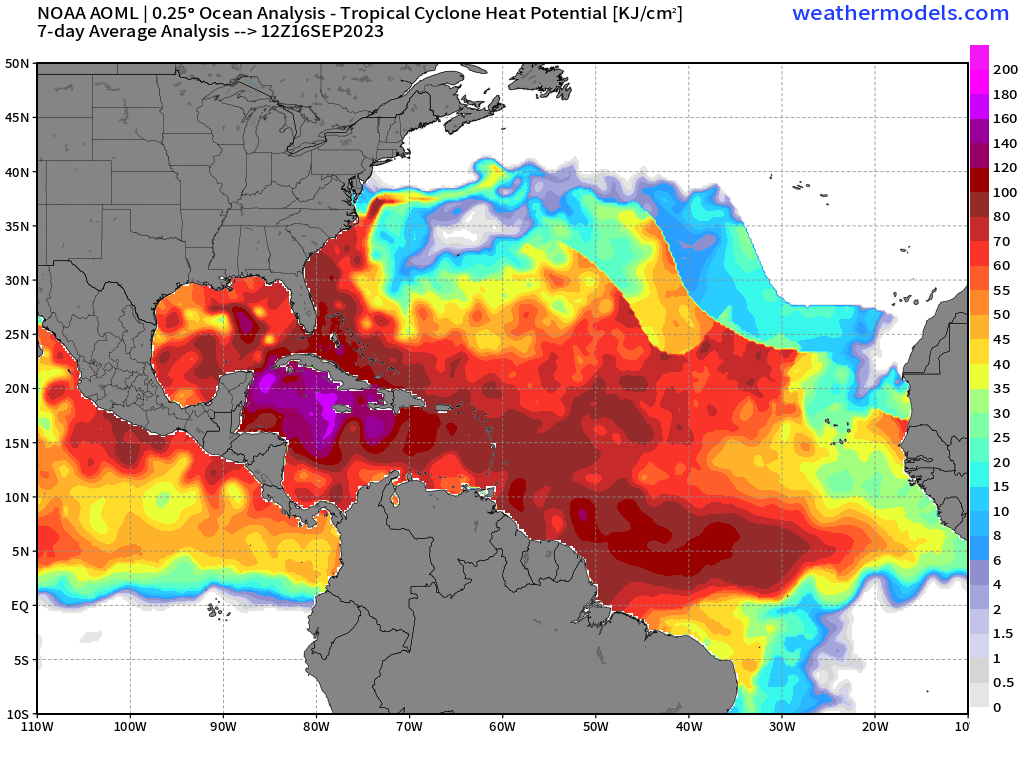
There isn't any special interaction with deeper waters, its all about how much water is being upwelled. Stronger systems have stronger winds and upwell more water but if they are moving fast, its not much of a factor. Lee travelled over modest OHC (60-80 KJ/sq.cm) and still explosively blew up to a C5 (third fastest to get to C5 in the NATL). Dorian is an example on the other spectrum where it pretty much stalled and the OHC helped sustain it but again that was because it stalled. It also depends on the size of the system, Dorian was a small system with a small radius of the most extreme winds so that also played into how much water was being upwelled. Remember Dorian did gradually start to weaken once it stalled over the Bahamas as the OHC was being depleted. It was also pretty much parked over the Gulf stream so that played a factor in sustaining it as well. Any system moving at a decent pace generally can work with even the most modest OHC as long as other conditions are favourable.
[url]https://i.postimg.cc/8z2cXc4H/image.png [/url]
I totally agree about the upwelling part being important, but cyclones also don't just interact with the surface of the water. I found the article I was reading earlier. The idea is that a stronger storm is going to be pulling heat from deeper waters, leading to more latent heat release. I tend to think of upwelling as a specific case where a storm has been sitting on an area long enough to exhaust heat from an area. That's definitely an area, as you said where OHC is critical.
I was more referring to the case where a storm is moving at a solid pace, even then two patches of identical SSTs may lead to two different rates of intensification. A great example of this was Katrina going over the loop eddy in the Gulf. Those eddys aren't really shown with a typical SST map yet they lead to an explosion in intensity. Only a look under the surface of the ocean reveals their nature. A given system may be able to work with moderate OHC, but that doesn't mean OHC isn't important for intensification. It's just another puzzle piece for figuring out the bigger picture.
If you have time, the paper really digs into the details and gives some solid examples. They improved the SHIPS model using such approach.
https://www.aoml.noaa.gov/phod/docs/I-Ilin.pdf
The article you linked pretty much explains what I said. Here are some important points:
Surface warm ocean features, such as Loop Current rings, exhibit a subsurface warm layer (e.g., the depth of the 26 C isotherm, D26) that is much deeper than their surrounding waters and, consequently, their associated TCHP is much higher. This deep, subsurface warm layer can constrain a cyclone’s self-induced ocean surface cooling and limit the normal negative intensity feedback, which then results in intensification (Cione and Uhlhorn 2003; Lin et al. 2005, 2008).
Remember, Katrina used here was moving relatively slowly while turning around in the Gulf (forward speed was just 5kt) while also continuing to extract heat from the same waters it passed over because of it's turn. The loop current is infamous for the reason Katrina and many other GoM systems blow up because it continuously keeps supplying very warm waters for any system where upwelling might be even remotely affecting it.
Based on 10 years of systematic analyses, results show that faster-moving typhoons can intensify to category-5 intensity over relatively lower upper-ocean heat content or TCHP (shallower layer of subsurface warm water) while slower-moving typhoons require much more TCHP for intensification to category 5 (Lin et al. 2009b). It has been found that a cyclone’s self-induced ocean cooling negative feedback is also a function of the translation speed, and there is much less ocean cooling induced when a cyclone travels faster. A faster-moving storm can ‘afford’ to intensify to category 5 over relatively shallower layer of warm water or lower TCHP.


