
I don't necessarily disagree with that premise, however it would be my contention that the large majority of Cape Verde storms would ultimately recurve in any given year, regardless whether the subtropics SST's were warm or cool. It would be interesting to look at data that correlated Cape Verde (E. Atlantic) tropical storm tracks during years having "cool" sub-tropic SST's, verses years with sub-tropic average to warm SST's. I could well be wrong but my guess is that there would be little distinction between those two groups. I think that sea surface pressures and/or strength (speed) of easterly trades would play a larger overall role whether any given year might produce an abundance of far East Atlantic tropical cyclones or not. Either hypothesis doesn't even take into consideration those years where SAL itself has implications inhibiting E. Atlantic development.
2024 Indicators: SST's, MSLP, Shear, SAL, Steering, Instability (Day 16+ Climate Models)
Moderator: S2k Moderators
Forum rules

The posts in this forum are NOT official forecasts and should not be used as such. They are just the opinion of the poster and may or may not be backed by sound meteorological data. They are NOT endorsed by any professional institution or STORM2K. For official information, please refer to products from the National Hurricane Center and National Weather Service.
Re: 2024 Indicators: SST's, MSLP, Shear, SAL, Steering, Instability (Day 16+ Climate Models)
I don't necessarily disagree with that premise, however it would be my contention that the large majority of Cape Verde storms would ultimately recurve in any given year, regardless whether the subtropics SST's were warm or cool. It would be interesting to look at data that correlated Cape Verde (E. Atlantic) tropical storm tracks during years having "cool" sub-tropic SST's, verses years with sub-tropic average to warm SST's. I could well be wrong but my guess is that there would be little distinction between those two groups. I think that sea surface pressures and/or strength (speed) of easterly trades would play a larger overall role whether any given year might produce an abundance of far East Atlantic tropical cyclones or not. Either hypothesis doesn't even take into consideration those years where SAL itself has implications inhibiting E. Atlantic development.
3 likes
Personal Forecast Disclaimer:
The posts in this forum are NOT official forecast and should not be used as such. They are just the opinion of the poster and may or may not be backed by sound meteorological data. They are NOT endorsed by any professional institution or storm2k.org. For official information, please refer to the NHC and NWS products.
The posts in this forum are NOT official forecast and should not be used as such. They are just the opinion of the poster and may or may not be backed by sound meteorological data. They are NOT endorsed by any professional institution or storm2k.org. For official information, please refer to the NHC and NWS products.
-
toad strangler

- S2K Supporter

- Posts: 4178
- Joined: Sun Jul 28, 2013 3:09 pm
- Location: Earth
- Contact:
Re: 2024 Indicators: SST's, MSLP, Shear, SAL, Steering, Instability (Day 16+ Climate Models)
Yaakov is doing significant back peddling after that initial thought. And his comment about there being 3 or more US landfalls in just 24% of seasons since 1900 has me scratching my head. That’s one of every four seasons. That’s a lot IMO.
0 likes
-
skyline385
- Category 5

- Posts: 2574
- Age: 33
- Joined: Wed Aug 26, 2020 11:15 pm
- Location: Houston TX
Re: 2024 Indicators: SST's, MSLP, Shear, SAL, Steering, Instability (Day 16+ Climate Models)
toad strangler wrote:Yaakov is doing significant back peddling after that initial thought. And his comment about there being 3 or more US landfalls in just 24% of seasons since 1900 has me scratching my head. That’s one of every four seasons. That’s a lot IMO.
If we are talking about just hurricanes (and not majors), then its likely true. I did not do the exact math but you can see tons of years with 3+ landfalling hurricanes on the hurdat page
https://www.aoml.noaa.gov/hrd/hurdat/Al ... canes.html
24% certainly seems possible looking at it.
1 likes

Re: 2024 Indicators: SST's, MSLP, Shear, SAL, Steering, Instability (Day 16+ Climate Models)
skyline385 wrote:toad strangler wrote:Yaakov is doing significant back peddling after that initial thought. And his comment about there being 3 or more US landfalls in just 24% of seasons since 1900 has me scratching my head. That’s one of every four seasons. That’s a lot IMO.
If we are talking about just hurricanes (and not majors), then its likely true. I did not do the exact math but you can see tons of years with 3+ landfalling hurricanes on the hurdat page
https://www.aoml.noaa.gov/hrd/hurdat/Al ... canes.html
24% certainly seems possible looking at it.
3+ hurricane landfalls also count more borderline storms like Barry 2019 and Nicole 2022. While they certainly do cause damage and disruption, they're nowhere near the kind of catastrophe that the 3+ figure itself may remind you of.
0 likes
-
Stratton23
- Category 2

- Posts: 645
- Joined: Fri Jul 21, 2023 10:59 pm
- Location: College Station, Tx
Re: 2024 Indicators: SST's, MSLP, Shear, SAL, Steering, Instability (Day 16+ Climate Models)
Man it is jaw dropping to see just how widespread and deep the upper ocean heat content is from the loop current in the gulf, western caribbean and far eastern caribbean, i have never seen that much UHC that widespread and deep in may, the atlantic/ caribbean could explode like an atom bomb with systems passing over all of that
1 likes


Re: 2024 Indicators: SST's, MSLP, Shear, SAL, Steering, Instability (Day 16+ Climate Models)
A while back, I did a bit of my own dive as I wanted to know what really makes a hurricane season tick. I spent a lot of time looking at metrics without really knowing how much they actually affect a season. I finally transferred the graphs and such over to my phone so I could post them here, as I figure some might find them interesting. The data used is from 1967 to 2022.
AMO positively correlates the cleanest, which makes sense as Atlantic warmth is the most important metric for a given season. The PDO and ENSO both correlate negatively with Atlantic hurricane season, though you can see the relationship is not as clean as AMO.
2024 is shaping up with all 3 of these variables in a state that supports lots of hurricane activity.
2 likes
Re: 2024 Indicators: SST's, MSLP, Shear, SAL, Steering, Instability (Day 16+ Climate Models)
skyline385 wrote:toad strangler wrote:Yaakov is doing significant back peddling after that initial thought. And his comment about there being 3 or more US landfalls in just 24% of seasons since 1900 has me scratching my head. That’s one of every four seasons. That’s a lot IMO.
If we are talking about just hurricanes (and not majors), then its likely true. I did not do the exact math but you can see tons of years with 3+ landfalling hurricanes on the hurdat page
https://www.aoml.noaa.gov/hrd/hurdat/Al ... canes.html
24% certainly seems possible looking at it.
Thanks for posting this link with this excellent data! They decided not to count 2022’s Nicole as a H landfall because the H winds never made it to FL. But I wonder if they could have listed it with an &, which means H landfall but with highest winds remaining offshore. Opinions?
1 likes
Personal Forecast Disclaimer:
The posts in this forum are NOT official forecasts and should not be used as such. They are just the opinion of the poster and may or may not be backed by sound meteorological data. They are NOT endorsed by any professional institution or storm2k.org. For official information, please refer to the NHC and NWS products.
The posts in this forum are NOT official forecasts and should not be used as such. They are just the opinion of the poster and may or may not be backed by sound meteorological data. They are NOT endorsed by any professional institution or storm2k.org. For official information, please refer to the NHC and NWS products.
-
skyline385
- Category 5
- Posts: 2574
- Age: 33
- Joined: Wed Aug 26, 2020 11:15 pm
- Location: Houston TX
Re: 2024 Indicators: SST's, MSLP, Shear, SAL, Steering, Instability (Day 16+ Climate Models)
LarryWx wrote:skyline385 wrote:toad strangler wrote:Yaakov is doing significant back peddling after that initial thought. And his comment about there being 3 or more US landfalls in just 24% of seasons since 1900 has me scratching my head. That’s one of every four seasons. That’s a lot IMO.
If we are talking about just hurricanes (and not majors), then its likely true. I did not do the exact math but you can see tons of years with 3+ landfalling hurricanes on the hurdat page
https://www.aoml.noaa.gov/hrd/hurdat/Al ... canes.html
24% certainly seems possible looking at it.
Thanks for posting this link with this excellent data! They decided not to count 2022’s Nicole as a H landfall because the H winds never made it to FL. But I wonder if they could have listed it with an &, which means H landfall but with highest winds remaining offshore. Opinions?
I agree, it was still a hurricane on landfall even if the winds didn't make it to Florida. For the sake of consistency, it would have made sense to include it.
3 likes
Re: 2024 Indicators: SST's, MSLP, Shear, SAL, Steering, Instability (Day 16+ Climate Models)
skyline385 wrote:toad strangler wrote:Yaakov is doing significant back peddling after that initial thought. And his comment about there being 3 or more US landfalls in just 24% of seasons since 1900 has me scratching my head. That’s one of every four seasons. That’s a lot IMO.
If we are talking about just hurricanes (and not majors), then its likely true. I did not do the exact math but you can see tons of years with 3+ landfalling hurricanes on the hurdat page
https://www.aoml.noaa.gov/hrd/hurdat/Al ... canes.html
24% certainly seems possible looking at it.
Years with 3+ CONUS H landfalls using hurdat:
1950-2023: these 16 of 74 seasons (22%) had 3+/ASO ONI
1950: -0.4
1953: +0.8
1954: -0.9
1959: -0.1
1964: -0.8
1971: -0.8
1979: +0.3
1985: -0.4
1989: -0.2
1998: -1.3
1999: -1.2
2004: +0.7
2005: -0.1
2008: -0.2
2017: -0.4
2020: -0.9
So, 3+ CONUS H seasons 1950-2023 with regard to ASO ONI:
Sub -1.0: 2 of 8 (25%)
-1.0 to -0.5: 4 of 13 (31%)
-0.4 to 0.0: 7 of 20 (35%)
+0.1 to +0.5: 1 of 13 (8%)
+0.6 to +1.0: 2 of 11 (18%)
Over +1.0: 0 of 9 (0%)
So, regarding ASO ONI since 1950, largest % of CONUS 3+ H seasons has been for -0.4 to 0.0 followed closely by -1.0 to -0.5 and then sub -1.0. Lowest % for over +1.0 followed by +0.1 to +0.5.
-La Niña overall: 6 of 21 (29%)
-El Niño overall: 2 of 20 (10%)
-Cold neutral way more than warm neutral
*Edit: Also, note that despite the big increase in activity since 1995 that the % of 3+ CONUS seasons has increased only modestly since 1995 (24%) vs that for 1950-1994 (20%).
ONI: https://origin.cpc.ncep.noaa.gov/produc ... ONI_v5.php
2 likes
Personal Forecast Disclaimer:
The posts in this forum are NOT official forecasts and should not be used as such. They are just the opinion of the poster and may or may not be backed by sound meteorological data. They are NOT endorsed by any professional institution or storm2k.org. For official information, please refer to the NHC and NWS products.
The posts in this forum are NOT official forecasts and should not be used as such. They are just the opinion of the poster and may or may not be backed by sound meteorological data. They are NOT endorsed by any professional institution or storm2k.org. For official information, please refer to the NHC and NWS products.
Re: 2024 Indicators: SST's, MSLP, Shear, SAL, Steering, Instability (Day 16+ Climate Models)
Based on HURDAT since 1950, the point at which the chance for 3+ CONUS landfalling storms as a H hits ~50% is when seasons have 10 hurricanes. For 8-9 H seasons, only 3 of 12 (25%) had 3+ CONUS LFing H. But for 10-11 H seasons, it rose to 60% (3 of 5) though it was 0 of the 2 twelve H seasons. The two 14-15 H seasons both had 3+ LF.
1 likes
Personal Forecast Disclaimer:
The posts in this forum are NOT official forecasts and should not be used as such. They are just the opinion of the poster and may or may not be backed by sound meteorological data. They are NOT endorsed by any professional institution or storm2k.org. For official information, please refer to the NHC and NWS products.
The posts in this forum are NOT official forecasts and should not be used as such. They are just the opinion of the poster and may or may not be backed by sound meteorological data. They are NOT endorsed by any professional institution or storm2k.org. For official information, please refer to the NHC and NWS products.
-
cycloneye

- Admin

- Posts: 139596
- Age: 67
- Joined: Thu Oct 10, 2002 10:54 am
- Location: San Juan, Puerto Rico
Re: 2024 Indicators: SST's, MSLP, Shear, SAL, Steering, Instability (Day 16+ Climate Models)
1 likes
Visit the Caribbean-Central America Weather Thread where you can find at first post web cams,radars
and observations from Caribbean basin members Click Here
and observations from Caribbean basin members Click Here
Re: 2024 Indicators: SST's, MSLP, Shear, SAL, Steering, Instability (Day 16+ Climate Models)
This tweet’s image clearly illustrates the idea of RONI, which is already nearing the -0.5 of La Niña (look at all of the blue along the equator in the E and C Pacific) vs the equivalent to ONI, which is still only down to ~+0.2 per OISST and CRW.
0 likes
Personal Forecast Disclaimer:
The posts in this forum are NOT official forecasts and should not be used as such. They are just the opinion of the poster and may or may not be backed by sound meteorological data. They are NOT endorsed by any professional institution or storm2k.org. For official information, please refer to the NHC and NWS products.
The posts in this forum are NOT official forecasts and should not be used as such. They are just the opinion of the poster and may or may not be backed by sound meteorological data. They are NOT endorsed by any professional institution or storm2k.org. For official information, please refer to the NHC and NWS products.
-
ScottNAtlanta

- Category 5
- Posts: 2014
- Joined: Sat May 25, 2013 3:11 pm
- Location: Atlanta, GA
Re: 2024 Indicators: SST's, MSLP, Shear, SAL, Steering, Instability (Day 16+ Climate Models)
chaser1 wrote:
I don't necessarily disagree with that premise, however it would be my contention that the large majority of Cape Verde storms would ultimately recurve in any given year, regardless whether the subtropics SST's were warm or cool. It would be interesting to look at data that correlated Cape Verde (E. Atlantic) tropical storm tracks during years having "cool" sub-tropic SST's, verses years with sub-tropic average to warm SST's. I could well be wrong but my guess is that there would be little distinction between those two groups. I think that sea surface pressures and/or strength (speed) of easterly trades would play a larger overall role whether any given year might produce an abundance of far East Atlantic tropical cyclones or not. Either hypothesis doesn't even take into consideration those years where SAL itself has implications inhibiting E. Atlantic development.
I think it's a bit too general to say that EATL systems will recurve. It depends on where that cooler subtropics is centered which in turn determines where the high pressure sets up. Usually systems that blow up very close to the Cabo Verde islands do move north, but once you start to move away from that area your chances diminish depending on the factors I just mentioned
3 likes
The posts in this forum are NOT official forecast and should not be used as such. They are just the opinion of the poster and may or may not be backed by sound meteorological data. They are NOT endorsed by any professional institution or storm2k.org. For official information, please refer to the NHC and NWS products.
-
skyline385
- Category 5
- Posts: 2574
- Age: 33
- Joined: Wed Aug 26, 2020 11:15 pm
- Location: Houston TX
Re: 2024 Indicators: SST's, MSLP, Shear, SAL, Steering, Instability (Day 16+ Climate Models)
ScottNAtlanta wrote:chaser1 wrote:
I don't necessarily disagree with that premise, however it would be my contention that the large majority of Cape Verde storms would ultimately recurve in any given year, regardless whether the subtropics SST's were warm or cool. It would be interesting to look at data that correlated Cape Verde (E. Atlantic) tropical storm tracks during years having "cool" sub-tropic SST's, verses years with sub-tropic average to warm SST's. I could well be wrong but my guess is that there would be little distinction between those two groups. I think that sea surface pressures and/or strength (speed) of easterly trades would play a larger overall role whether any given year might produce an abundance of far East Atlantic tropical cyclones or not. Either hypothesis doesn't even take into consideration those years where SAL itself has implications inhibiting E. Atlantic development.
I think it's a bit too general to say that EATL systems will recurve. It depends on where that cooler subtropics is centered which in turn determines where the high pressure sets up. Usually systems that blow up very close to the Cabo Verde islands do move north, but once you start to move away from that area your chances diminish depending on the factors I just mentioned
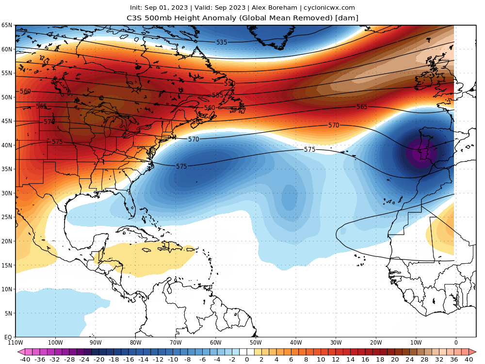
It will also end up depending on where the weakness in the ridging will be when the system forms. If something like May's C3S forecast for Sep 24 were to verify, chances for recurve would be limited.

For comparison, this was the Sep 23 C3S run
2 likes
-
cycloneye
- Admin
- Posts: 139596
- Age: 67
- Joined: Thu Oct 10, 2002 10:54 am
- Location: San Juan, Puerto Rico
Re: 2024 Indicators: SST's, MSLP, Shear, SAL, Steering, Instability (Day 16+ Climate Models)
0 likes
Visit the Caribbean-Central America Weather Thread where you can find at first post web cams,radars
and observations from Caribbean basin members Click Here
and observations from Caribbean basin members Click Here

Re: 2024 Indicators: SST's, MSLP, Shear, SAL, Steering, Instability (Day 16+ Climate Models)
Since this is a transition period from El Niño to La Niña, that can also have an impact on tracks. Transition years can favor storms further west.
1 likes
-
toad strangler
- S2K Supporter
- Posts: 4178
- Joined: Sun Jul 28, 2013 3:09 pm
- Location: Earth
- Contact:
Re: 2024 Indicators: SST's, MSLP, Shear, SAL, Steering, Instability (Day 16+ Climate Models)
Here's all hyperactive seasons occurring after 1967 seasons in order by ACE (ignoring those before 1967 due to limited satellite observations and as such a bias toward landfalls):
Hurricane Landfalls:
2005: Very Impactful Season
1995: Impactful Season
2004: Very Impactful Season
2017: Very Impactful Season
1998: Impactful Season
2020: Very Impactful Season
2003: A Few Impacting Minor Hurricanes
1999: Impactful Season
1996: Impactful Season
1969: Impactful Season
2010: Multiple Landfalls (None in US, but there were notable hits in Central America)
Not to be all doom and gloom, but every hyperactive season in the Satellite era has lead to Hurricanes landfalling somewhere, usually quite impactful. Even 2010 noted as the quiet season sent a Category 3 into Mexico. A hyperactive season not having impactful hits is the exception, not the norm.
1 likes
-
cycloneye
- Admin
- Posts: 139596
- Age: 67
- Joined: Thu Oct 10, 2002 10:54 am
- Location: San Juan, Puerto Rico
Re: 2024 Indicators: SST's, MSLP, Shear, SAL, Steering, Instability (Day 16+ Climate Models)
0 likes
Visit the Caribbean-Central America Weather Thread where you can find at first post web cams,radars
and observations from Caribbean basin members Click Here
and observations from Caribbean basin members Click Here
-
Category5Kaiju

- Category 5
- Posts: 3438
- Age: 22
- Joined: Thu Dec 24, 2020 12:45 pm
- Location: Seattle
Re: RE: Re: 2024 Indicators: SST's, MSLP, Shear, SAL, Steering, Instability (Day 16+ Climate Models)
Woofde wrote:Here's all hyperactive seasons occurring after 1967 seasons in order by ACE (ignoring those before 1967 due to limited satellite observations and as such a bias toward landfalls):toad strangler wrote:https://twitter.com/andyhazelton/status/1794050951025709380?s=46
Hurricane Landfalls:
2005: Very Impactful Season
1995: Impactful Season
2004: Very Impactful Season
2017: Very Impactful Season
1998: Impactful Season
2020: Very Impactful Season
2003: A Few Impacting Minor Hurricanes
1999: Impactful Season
1996: Impactful Season
1969: Impactful Season
2010: Multiple Landfalls (None in US, but there were notable hits in Central America)
Not to be all doom and gloom, but every hyperactive season in the Satellite era has lead to Hurricanes landfalling somewhere, usually quite impactful. Even 2010 noted as the quiet season sent a Category 3 into Mexico. A hyperactive season not having impactful hits is the exception, not the norm.
Also, I find Hurricane Earl from 2010 to be an interesting case. Imho, on the levels of “what if Irma didn’t hit Cuba or what if Lane 2018 continued on northward”
If you look at Earl’s track, we got extremely lucky with that storm. Had that track been the same except shifted some miles to the west, Earl would’ve been a major disaster for the Greater Antilles, possible the Bahamas, and would’ve hit North Carolina as a major hurricane. 2010 would’ve been remembered very differently had Earl simply nudged a bit further west.
3 likes
Unless explicitly stated, all information covered in my posts is based on my opinions and observations. Please refer to a professional meteorologist or an accredited weather research agency otherwise, especially if serious decisions must be made in the event of a potentially life-threatening tropical storm or hurricane.
Who is online
Users browsing this forum: BigB0882, cainjamin, cheezyWXguy, Cpv17, duilaslol, idaknowman, jgh, MetroMike, ScottNAtlanta, skyline385, TheAustinMan, Wampadawg and 85 guests