I think relativity is important here.
If the subtropics are warm but the MDR is even warmer, then you can bet that that would certainly favor deep tropical activity. If the opposite is true, then (as we saw with years like 2022) that would cause serious instability issues.
Long range models seem to suggest that the deep tropics will remain warmer than the subtropics going into hurricane season. I don't think anything has changed on that end.
2024 Indicators: SST's, MSLP, Shear, SAL, Steering, Instability (Day 16+ Climate Models)
Moderator: S2k Moderators
Forum rules

The posts in this forum are NOT official forecasts and should not be used as such. They are just the opinion of the poster and may or may not be backed by sound meteorological data. They are NOT endorsed by any professional institution or STORM2K. For official information, please refer to products from the National Hurricane Center and National Weather Service.
-
Category5Kaiju

- Category 5

- Posts: 3747
- Joined: Thu Dec 24, 2020 12:45 pm
- Location: Seattle
Re: 2024 Indicators: SST's, MSLP, Shear, SAL, Steering, Instability (Day 16+ Climate Models)
0 likes
Unless explicitly stated, all information covered in my posts is based on my own opinions and observations. Please refer to a professional meteorologist or an accredited weather research agency otherwise, especially if serious decisions must be made in the event of a potentially life-threatening tropical storm or hurricane.
-
skyline385

- Category 5
- Posts: 2721
- Age: 34
- Joined: Wed Aug 26, 2020 11:15 pm
- Location: Houston TX
Re: RE: Re: RE: Re: 2024 Indicators: SST's, MSLP, Shear, SAL, Steering, Instability (Day 16+ Climate Models)
WeatherBoy2000 wrote:Woofde wrote:It's almost expected just based on recent seasons. We haven't really had a season with cool subtropics by peak season in recent memory.skyline385 wrote:
There has certainly been some very notable warming of the subtropics in the last 15 days, the classical +AMO look is gone again.
[url]https://i.postimg.cc/L4jTbtG6/image.png [/url]
[url]https://i.postimg.cc/bw5kJr4B/image.png [/url]
For example 2017 and 2020 both played out this exact way. Both had large cool patches around this same time, but by August they warmed significantly.https://uploads.tapatalk-cdn.com/20240527/00773bb5ee877206995e9f7cf9218004.jpg https://uploads.tapatalk-cdn.com/20240527/3f926f937f879dc03ab995bd901e664c.jpg https://uploads.tapatalk-cdn.com/20240527/ed272918c2b7de1891bee97c77f7aa6b.jpg https://uploads.tapatalk-cdn.com/20240527/abce34f487cff56f5ea4e5356099dfa9.jpg
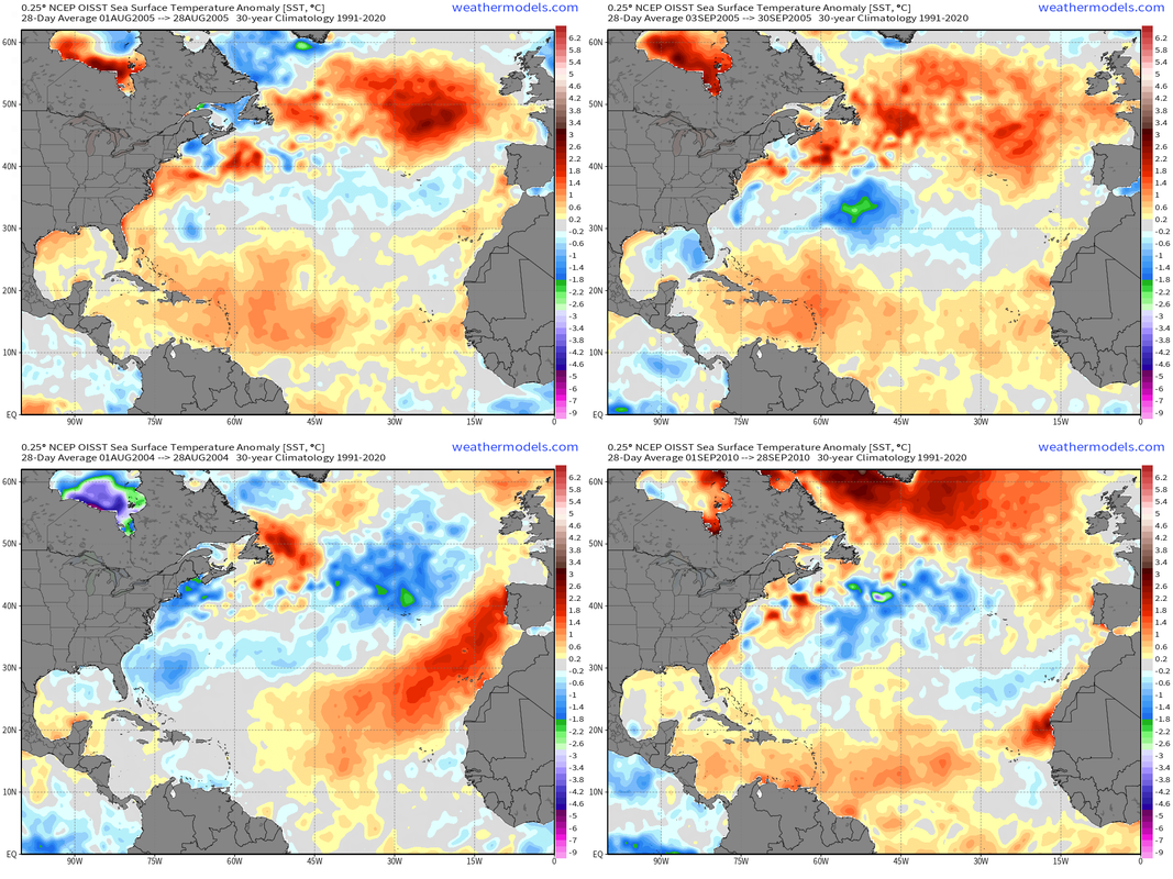
Goes back even further than 2017/2020, same thing happened in 2005 and 2010 as well:
2005:
2010:
Lots of things going on here.
1) We have had a persistent subtropical warm blob in recent years which would intensify and induce stable air through the MDR. That's not what this is at the moment, we just went through a round of +NAO and this will most likely undo itself once we go back to -NAO.
2) We can't cherry pick a month out of a few years and generalize it to say that it happens everytime in the NATL because that is really not true. A cold pool also doesn't have to be right off the US coast, sub-tropics start from 23.5N. 2005 in particular was notorious for a pretty decent +AMO setup with a persistent cold pool in the subtropics. You can see it the August and September plots below. 2004 August had one of the most impressive +AMO setups as well. And there was a strong cold pool during 2010 September as well.
0 likes
-
WeatherBoy2000
- Tropical Storm

- Posts: 168
- Joined: Mon Apr 10, 2023 9:29 am
Re: RE: Re: RE: Re: 2024 Indicators: SST's, MSLP, Shear, SAL, Steering, Instability (Day 16+ Climate Models)
skyline385 wrote:WeatherBoy2000 wrote:Woofde wrote:It's almost expected just based on recent seasons. We haven't really had a season with cool subtropics by peak season in recent memory.
For example 2017 and 2020 both played out this exact way. Both had large cool patches around this same time, but by August they warmed significantly.https://uploads.tapatalk-cdn.com/20240527/00773bb5ee877206995e9f7cf9218004.jpg https://uploads.tapatalk-cdn.com/20240527/3f926f937f879dc03ab995bd901e664c.jpg https://uploads.tapatalk-cdn.com/20240527/ed272918c2b7de1891bee97c77f7aa6b.jpg https://uploads.tapatalk-cdn.com/20240527/abce34f487cff56f5ea4e5356099dfa9.jpg
Goes back even further than 2017/2020, same thing happened in 2005 and 2010 as well:
2005:
2010:
Lots of things going on here.
1) We have had a persistent subtropical warm blob for the last 3-4 years which would intensify and induce stable air through the MDR. That's not what this is at the moment, we just went through a round of +NAO and this will most likely undo itself once we go back to -NAO.
2) We can't cherry pick a month out of a few years and generalize it to say that it happens everytime in the NATL because that is really not true. A cold pool also doesn't have to be right off the US coast, sub-tropics start from 23.5N. 2005 in particular was notorious for a pretty decent +AMO setup with a persistent cold pool in the subtropics. You can see it the August and September plots below. 2004 August had one of the most impressive +AMO setups as well. And there was a strong cold pool during 2010 September as well.
[url]https://i.postimg.cc/435GHGb0/combine-images.png [/url]
I was more responding to the fact that both 2005/2010 developed the basin wide warmth look in August regardless if they reverted back somewhat by September/October. I agree that we shouldn't just cherry pick specific months or even days when talking about Atlantic ssts, trimonthly periods (ASO) are much more reliable at representing the overall theme for any given season. Even last year developed a basin wide warmth look in July/August before reverting back to the more typical +amo look later in the year.
0 likes
-
tolakram
- Admin

- Posts: 19545
- Age: 61
- Joined: Sun Aug 27, 2006 8:23 pm
- Location: Florence, KY (name is Mark)
Re: 2024 Indicators: SST's, MSLP, Shear, SAL, Steering, Instability (Day 16+ Climate Models)
I want to go on record (pun intended) as stating that I don't believe we can predict a record season on either side of normal. The impacts of this season will be landfalls anywhere and the number of them, not storm count. I feel like number of storms is a rather random event controlled by factors that really can't be predicted pre season. Number of waves, where shear is low, tracks, etc.
We've just had a number of responses over a season cancel question. Let's not This season can do nothing except either live up to extreme expectations or bust horribly, I don't see any in between. My prediction is for a busy season with hopefully a lot of true fish (0 landfalls).
We've just had a number of responses over a season cancel question. Let's not
3 likes
M a r k
- - - - -
Join us in chat: Storm2K Chatroom Invite. Android and IOS apps also available.
The posts in this forum are NOT official forecasts and should not be used as such. Posts are NOT endorsed by any professional institution or STORM2K.org. For official information and forecasts, please refer to NHC and NWS products.


Re: RE: Re: RE: Re: RE: Re: 2024 Indicators: SST's, MSLP, Shear, SAL, Steering, Instability (Day 16+ Climate Models)
I wasn't trying to cherry pick a month, the thought I had was "Let's see how SSTs evolve from where we are to the start of peak season." That's why I went for August. The Subtropics begin to rapidly cool back down come September due to seasonal cooling, so a previous look may return then after heating is done.skyline385 wrote:WeatherBoy2000 wrote:Woofde wrote:It's almost expected just based on recent seasons. We haven't really had a season with cool subtropics by peak season in recent memory.
For example 2017 and 2020 both played out this exact way. Both had large cool patches around this same time, but by August they warmed significantly.https://uploads.tapatalk-cdn.com/20240527/00773bb5ee877206995e9f7cf9218004.jpg https://uploads.tapatalk-cdn.com/20240527/3f926f937f879dc03ab995bd901e664c.jpg https://uploads.tapatalk-cdn.com/20240527/ed272918c2b7de1891bee97c77f7aa6b.jpg https://uploads.tapatalk-cdn.com/20240527/abce34f487cff56f5ea4e5356099dfa9.jpg
Goes back even further than 2017/2020, same thing happened in 2005 and 2010 as well:
2005:
2010:
Lots of things going on here.
1) We have had a persistent subtropical warm blob in recent years which would intensify and induce stable air through the MDR. That's not what this is at the moment, we just went through a round of +NAO and this will most likely undo itself once we go back to -NAO.
2) We can't cherry pick a month out of a few years and generalize it to say that it happens everytime in the NATL because that is really not true. A cold pool also doesn't have to be right off the US coast, sub-tropics start from 23.5N. 2005 in particular was notorious for a pretty decent +AMO setup with a persistent cold pool in the subtropics. You can see it the August and September plots below. 2004 August had one of the most impressive +AMO setups as well. And there was a strong cold pool during 2010 September as well.
It's certainly possible NAO swaps, and then maybe this look holds on through peak season. It would just be very anomalous compared to the last 10-15 years.
0 likes

Re: 2024 Indicators: SST's, MSLP, Shear, SAL, Steering, Instability (Day 16+ Climate Models)
I think we can assume the subtropics will be much warmer than normal by peak of the hurricane season because yes, that is just how it has been for as long as I can remember. The talk of stability in the deep tropics is always a topic every season and folks speculate if it will impact the season and it usually does, as seen by our lack of MDR activity for the last decade (except 2017 and 2021(maybe)). I would expect the same this year, with most of the strongest activity happening outside the deep tropics and Caribbean Sea. I expect Andy Hazelton to come out with this very observation soon...surprised he hasn't already because he usually is the one to first bring it up
1 likes
-
skyline385
- Category 5
- Posts: 2721
- Age: 34
- Joined: Wed Aug 26, 2020 11:15 pm
- Location: Houston TX
Re: 2024 Indicators: SST's, MSLP, Shear, SAL, Steering, Instability (Day 16+ Climate Models)
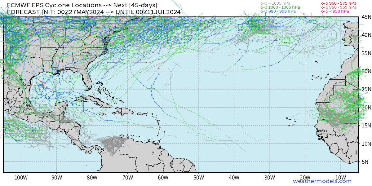
Long range EPS starting to show some activity including a few Caribbean cruisers. Just more signs that favorable conditions should be arriving soon with the MJO passage.
4 likes
-
DorkyMcDorkface

- Category 2

- Posts: 787
- Age: 26
- Joined: Mon Sep 30, 2019 1:32 pm
- Location: Mid-Atlantic
Re: 2024 Indicators: SST's, MSLP, Shear, SAL, Steering, Instability (Day 16+ Climate Models)
WiscoWx02 wrote:I think we can assume the subtropics will be much warmer than normal by peak of the hurricane season because yes, that is just how it has been for as long as I can remember. The talk of stability in the deep tropics is always a topic every season and folks speculate if it will impact the season and it usually does, as seen by our lack of MDR activity for the last decade (except 2017 and 2021(maybe)). I would expect the same this year, with most of the strongest activity happening outside the deep tropics and Caribbean Sea. I expect Andy Hazelton to come out with this very observation soon...surprised he hasn't already because he usually is the one to first bring it up
I'm not seeing anything at the present time to suggest the subtropics will warm up appreciably to the point where it would outpace the warmth in the tropics and cause significant stability issues as a result. All of the reliable guidance shows the strong +AMO signature generally sustaining itself throughout the year, and a drastic pattern change would have to commence in order to fully break that down. While it certainly isn't unreasonable to expect the subtropics to warm a bit come ASO, it will still be difficult to get the region to a level on par with or over what we've seen in the MDR and Caribbean up to this point (or to have those cool down significantly enough to where the subtropics eventually overpower them). Yes it's happened a few times in recent years, but that doesn't automatically mean it's a lock to happen again this year.
3 likes
Floyd 1999 | Isabel 2003 | Hanna 2008 | Irene 2011 | Sandy 2012 | Isaias 2020
-
South Texas Storms

- Professional-Met

- Posts: 4096
- Joined: Thu Jun 24, 2010 12:28 am
- Location: Houston, TX
Re: 2024 Indicators: SST's, MSLP, Shear, SAL, Steering, Instability (Day 16+ Climate Models)
skyline385 wrote:Long range EPS starting to show some activity including a few Caribbean cruisers. Just more signs that favorable conditions should be arriving soon with the MJO passage.
[url]https://i.postimg.cc/PxsSfXQB/image.png [/url]
The extended range GFS and Euro model guidance have consistently been indicating above normal rainfall in the western Gulf during the last week of June and into the first few days of July. Decent chance we see some tropical activity in this region around this time based on the latest data.
1 likes
-
Category5Kaiju
- Category 5
- Posts: 3747
- Joined: Thu Dec 24, 2020 12:45 pm
- Location: Seattle
Re: 2024 Indicators: SST's, MSLP, Shear, SAL, Steering, Instability (Day 16+ Climate Models)
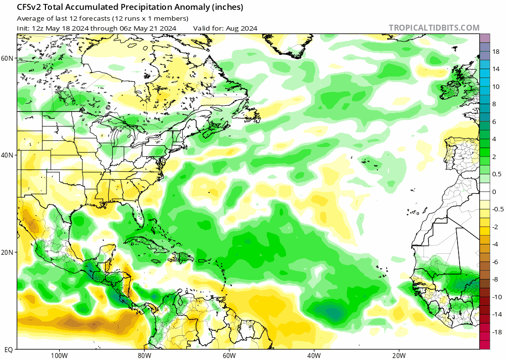
Fyi, this is what the recent CFS has in store for the month of August. As you can see, the subtropics are somewhat warmer, but the deep tropics are much warmer relative to the subtropics. This general look has remained pretty consistent across multiple runs.
In my humble opinion, this doesn't necessarily strike me as a "subtropics-inducing stability-to-the-tropics" type of setup. We also have to understand that just because recent years had stability in the tropics doesn't necessarily alone mean that 2024 must follow suit per se.

In my humble opinion, this doesn't necessarily strike me as a "subtropics-inducing stability-to-the-tropics" type of setup. We also have to understand that just because recent years had stability in the tropics doesn't necessarily alone mean that 2024 must follow suit per se.
6 likes
Unless explicitly stated, all information covered in my posts is based on my own opinions and observations. Please refer to a professional meteorologist or an accredited weather research agency otherwise, especially if serious decisions must be made in the event of a potentially life-threatening tropical storm or hurricane.
Re: RE: Re: 2024 Indicators: SST's, MSLP, Shear, SAL, Steering, Instability (Day 16+ Climate Models)
Yeah I doubt it will be a major hindrance to stability even if warming does occur. The tropics should still maintain a leg up. We also will have a cool neutral/nina and -PDO to help out on that front.Category5Kaiju wrote:Fyi, this is what the recent CFS has in store for the month of August. As you can see, the subtropics are somewhat warmer, but the deep tropics are much warmer relative to the subtropics. This general look has remained pretty consistent across multiple runs.
In my humble opinion, this doesn't necessarily strike me as a "subtropics-inducing stability-to-the-tropics" type of setup. We also have to understand that just because recent years had stability in the tropics doesn't necessarily alone mean that 2024 must follow suit per se.
0 likes
-
cycloneye

- Admin
- Posts: 141206
- Age: 68
- Joined: Thu Oct 10, 2002 10:54 am
- Location: San Juan, Puerto Rico
Re: 2024 Indicators: SST's, MSLP, Shear, SAL, Steering, Instability (Day 16+ Climate Models)
The NAO (North Atlantic Occillation) will go to negative in the comming days, and that will warm the waters even more at MDR / Caribbean.

0 likes
Visit the Caribbean-Central America Weather Thread where you can find at first post web cams,radars
and observations from Caribbean basin members Click Here
and observations from Caribbean basin members Click Here
-
cycloneye
- Admin
- Posts: 141206
- Age: 68
- Joined: Thu Oct 10, 2002 10:54 am
- Location: San Juan, Puerto Rico
Re: 2024 Indicators: SST's, MSLP, Shear, SAL, Steering, Instability (Day 16+ Climate Models)
1 likes
Visit the Caribbean-Central America Weather Thread where you can find at first post web cams,radars
and observations from Caribbean basin members Click Here
and observations from Caribbean basin members Click Here
-
skyline385
- Category 5
- Posts: 2721
- Age: 34
- Joined: Wed Aug 26, 2020 11:15 pm
- Location: Houston TX
Re: 2024 Indicators: SST's, MSLP, Shear, SAL, Steering, Instability (Day 16+ Climate Models)
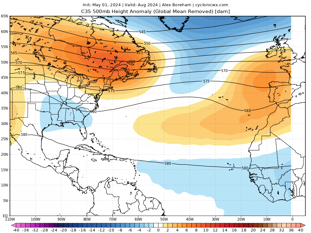
Current CFS trend moving towards some recurves with few managing to get into the GoM in August which is very believable and also matches with the C3S 500mb from last month although the CFS might have a stronger ridge over the US compared to the C3S.
0 likes
-
Stratton23
- Category 5
- Posts: 1112
- Joined: Fri Jul 21, 2023 10:59 pm
- Location: College Station, Tx
Re: 2024 Indicators: SST's, MSLP, Shear, SAL, Steering, Instability (Day 16+ Climate Models)
Im not putting much stock into the CFS right now, it still is alone, the cansips and NNME do not agree with it
0 likes
-
skyline385
- Category 5
- Posts: 2721
- Age: 34
- Joined: Wed Aug 26, 2020 11:15 pm
- Location: Houston TX
Re: 2024 Indicators: SST's, MSLP, Shear, SAL, Steering, Instability (Day 16+ Climate Models)
Stratton23 wrote:Im really hesitant to believe that we will see alot of recurves especially since the CFS continues to be alone with its solution , my money is on a stronger bermuda high, CFS is still alone so i dont buy it yet, the Cansips and NNME certainly do not agree with the CFS at all
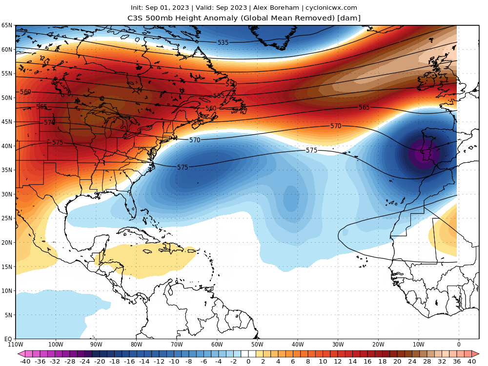
CanSIPS and NMME are still only at May while CFS runs 4x daily so it moves around a lot based on data fed into it. We will find out more from the June runs of CanSIPS and NMME but a few recurves are not impossible. CFS is also showing a mixture of recurves and GoM systems which also makes sense when you look at the C3S 500mb plot which is an ensemble of multiple seasonal models:
https://confluence.ecmwf.int/display/CKB/Description+of+the+C3S+seasonal+multi-system
Regardless these are just low resolution climate models and everyone on the coast should be prepared irrespective of whether there are recurves or not. One system is all it takes.
0 likes
-
Stratton23
- Category 5
- Posts: 1112
- Joined: Fri Jul 21, 2023 10:59 pm
- Location: College Station, Tx
Re: 2024 Indicators: SST's, MSLP, Shear, SAL, Steering, Instability (Day 16+ Climate Models)
Skyline385 oh no i agree their will be recurves from time to time, I just dont think we will see as many compared to last year, especially if something develops closer to home, with all that energy building in the western caribbean and gulf, its hard to imagine at least a few systems not getting into those areas lol
0 likes
-
SFLcane

- S2K Supporter

- Posts: 9833
- Age: 46
- Joined: Sat Jun 05, 2010 1:44 pm
- Location: Lake Worth Florida
Re: 2024 Indicators: SST's, MSLP, Shear, SAL, Steering, Instability (Day 16+ Climate Models)
skyline385 wrote:Current CFS trend moving towards some recurves with few managing to get into the GoM in August which is very believable and also matches with the C3S 500mb from last month although the CFS might have a stronger ridge over the US compared to the C3S.
[url]https://i.postimg.cc/mk0ZG54Y/20e26384-161d-4258-ba0f-a5327ff6b1e9.gif [/url]
[url]https://i.postimg.cc/x1VjxhtY/image.png [/url]
Surely agree there will be some recurves as they are usually are in every season but i also think the caribbean will very active this yr.
2 likes
-
Category5Kaiju
- Category 5
- Posts: 3747
- Joined: Thu Dec 24, 2020 12:45 pm
- Location: Seattle
Re: 2024 Indicators: SST's, MSLP, Shear, SAL, Steering, Instability (Day 16+ Climate Models)
SFLcane wrote:skyline385 wrote:Current CFS trend moving towards some recurves with few managing to get into the GoM in August which is very believable and also matches with the C3S 500mb from last month although the CFS might have a stronger ridge over the US compared to the C3S.
[url]https://i.postimg.cc/mk0ZG54Y/20e26384-161d-4258-ba0f-a5327ff6b1e9.gif [/url]
[url]https://i.postimg.cc/x1VjxhtY/image.png [/url]
Surely agree there will be some recurves as they are usually are in every season but i also think the caribbean will very active this yr.
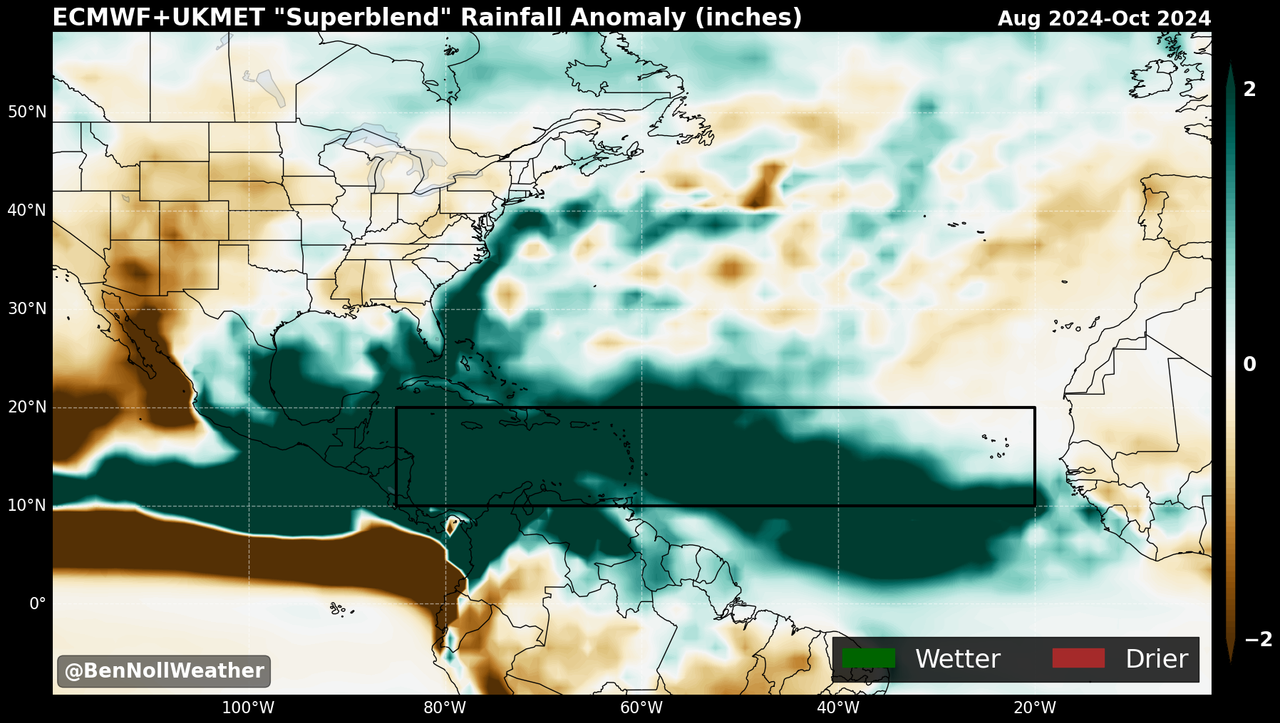
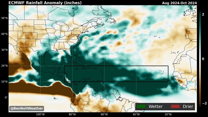
https://i.postimg.cc/Y9mfM0q7/superblend.png
https://i.postimg.cc/XqSKJWpC/HGHGHG.jpg
Just by looking at those maps, that doesn’t really look like a recurving pattern as we’ve seen in years like 2021 or 2023. Yeah sure several storms will recurve, no doubt about that. But the vast bulk of the wet anomalies are literally coating the entire Western Atlantic, and I can’t really seem to find a density of tracks that indicate many out of sea systems.
3 likes
Unless explicitly stated, all information covered in my posts is based on my own opinions and observations. Please refer to a professional meteorologist or an accredited weather research agency otherwise, especially if serious decisions must be made in the event of a potentially life-threatening tropical storm or hurricane.
-
skyline385
- Category 5
- Posts: 2721
- Age: 34
- Joined: Wed Aug 26, 2020 11:15 pm
- Location: Houston TX
Re: 2024 Indicators: SST's, MSLP, Shear, SAL, Steering, Instability (Day 16+ Climate Models)
Category5Kaiju wrote:SFLcane wrote:skyline385 wrote:Current CFS trend moving towards some recurves with few managing to get into the GoM in August which is very believable and also matches with the C3S 500mb from last month although the CFS might have a stronger ridge over the US compared to the C3S.
[url]https://i.postimg.cc/mk0ZG54Y/20e26384-161d-4258-ba0f-a5327ff6b1e9.gif [/url]
[url]https://i.postimg.cc/x1VjxhtY/image.png [/url]
Surely agree there will be some recurves as they are usually are in every season but i also think the caribbean will very active this yr.
https://i.postimg.cc/Y9mfM0q7/superblend.png
https://i.postimg.cc/XqSKJWpC/HGHGHG.jpg
Just by looking at those maps, that doesn’t really look like a recurving pattern as we’ve seen in years like 2021 or 2023. Yeah sure several storms will recurve, no doubt about that. But the vast bulk of the wet anomalies are literally coating the entire Western Atlantic, and I can’t really seem to find a density of tracks that indicate many out of sea systems.
Not really sure why people are misinterpreting those maps with me saying everything will recurve when I said "some recurves" twice already. 2023 was a Nino fueled by a warm NATL, which is why we had so many recurves. Its not going to be happening again. As I have said already, there is potential for some recurves while some will make it into the GoM.
I also shared the 2024 vs 2023 C3S 500mb plots couple of pages back to explain how the setup was completely different last year compared to what is forecast and recurves are going to be limited.
https://www.storm2k.org/phpbb2/viewtopic.php?p=3065425#p3065425
It will also end up depending on where the weakness in the ridging will be when the system forms. If something like May's C3S forecast for Sep 24 were to verify, chances for recurve would be limited.

For comparison, this was the Sep 23 C3S run
For comparison, this was the Sep 23 C3S run
Last edited by skyline385 on Tue May 28, 2024 4:05 pm, edited 2 times in total.
1 likes
Who is online
Users browsing this forum: 7cardinal, Blown Away, chaser1, Craters, ElectricStorm, Europa non è lontana, floridasun, FLpanhandle91, gib, gta251990, Hurricaneman, jgh, Monsoonjr99, otowntiger, pepecool20, Rica7117, SconnieCane, Stormybajan, Stratton23, Teban54 and 117 guests