2025 Global Model Runs Discussion (Out thru day 16)
Moderator: S2k Moderators
Forum rules

The posts in this forum are NOT official forecasts and should not be used as such. They are just the opinion of the poster and may or may not be backed by sound meteorological data. They are NOT endorsed by any professional institution or STORM2K. For official information, please refer to products from the National Hurricane Center and National Weather Service.
-
Hurricane Mike
- Category 2

- Posts: 675
- Joined: Tue Apr 10, 2018 7:44 am
Re: 2025 Global Model Runs Discussion (Out thru day 16)
The last few runs of the GFS show a hurricane threat to Western Florida mid November.
0 likes
-
crownweather

- S2K Supporter

- Posts: 602
- Age: 51
- Joined: Sat Aug 12, 2006 9:21 am
- Location: Sturbridge, Massachusetts
- Contact:
Re: 2025 Global Model Runs Discussion (Out thru day 16)
Hurricane Mike wrote:The last few runs of the GFS show a hurricane threat to Western Florida mid November.
Yeah, probably not going to happen. It's likely the GFS doing GFS things. Probably a erroneous spin-up that always occurs with the GFS model this time of year. Until other models jump on-board, I'm discounting.
1 likes
Rob Lightbown
Crown Weather Services
https://crownweather.com
Crown Weather Services
https://crownweather.com

Re: 2025 Global Model Runs Discussion (Out thru day 16)
GFS not the only one. 00z Icon and 12z CMC and GEFS showing something.
4 likes
The following post is NOT an official forecast and should not be used as such. It is just the opinion of the poster and may or may not be backed by sound meteorological data. It is NOT endorsed by any professional institution including storm2k.org For Official Information please refer to the NHC and NWS products.

Re: 2025 Global Model Runs Discussion (Out thru day 16)
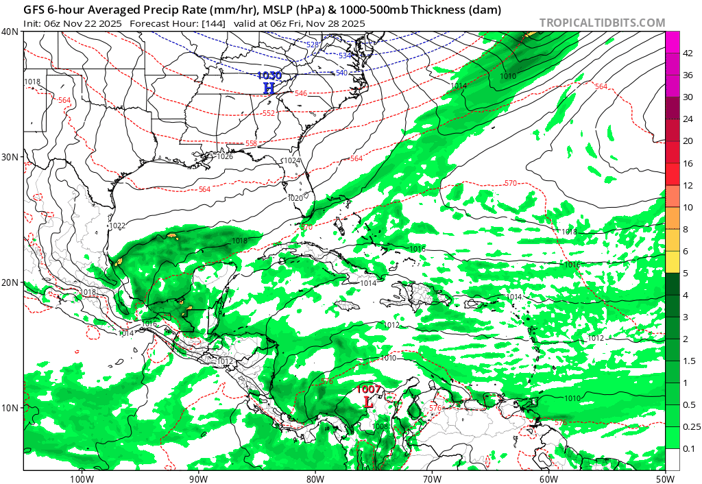
GFS continues to show a quick spinup in the SW Caribbean next Wednesday, briefly getting below 1000 mb before landfall in Nicaragua. It's now almost in the 5-day frame.
ICON shows a broad low; not much on other models.

ICON shows a broad low; not much on other models.
3 likes
TC naming lists: retirements and intensity
Most aggressive Advisory #1's in North Atlantic (cr. kevin for starting the list)
Most aggressive Advisory #1's in North Atlantic (cr. kevin for starting the list)

Re: 2025 Global Model Runs Discussion (Out thru day 16)
I'll say this much, unless something does try and coalesce as GFS is hinting, I think we can finally put a bow on this season. The 700mb -300 mb Relative Humidity forecast for 11/20 shows exceedingly dry air from behind the front to envelope most of the Central & Western Caribbean. By that time we'll be nearing the end of the season and it would take some time for any Gyre to propagate northward and modify the air down there.
I suppose there's a slim <10 chance of a quick trigger TS forming in the nearer term down there in the 5-7 day range but beyond that, 2025 should be a wrap.
I suppose there's a slim <10 chance of a quick trigger TS forming in the nearer term down there in the 5-7 day range but beyond that, 2025 should be a wrap.
3 likes
Andy D
(For official information, please refer to the NHC and NWS products.)
(For official information, please refer to the NHC and NWS products.)

Re: 2025 Global Model Runs Discussion (Out thru day 16)
The GFS doesn't think the season is over...while its doubtful we could see a MDR storm this late, perhaps its something to watch next week.
3 likes
-
Ivanhater

- Storm2k Moderator

- Posts: 11166
- Age: 38
- Joined: Fri Jul 01, 2005 8:25 am
- Location: Pensacola
Re: 2025 Global Model Runs Discussion (Out thru day 16)
Gfs has been showing a tropical storm hitting the Florida panhandle first week of December 
0 likes
Michael
Re: 2025 Global Model Runs Discussion (Out thru day 16)
Ivanhater wrote:Gfs has been showing a tropical storm hitting the Florida panhandle first week of December
0 likes
TC naming lists: retirements and intensity
Most aggressive Advisory #1's in North Atlantic (cr. kevin for starting the list)
Most aggressive Advisory #1's in North Atlantic (cr. kevin for starting the list)
Re: 2025 Global Model Runs Discussion (Out thru day 16)
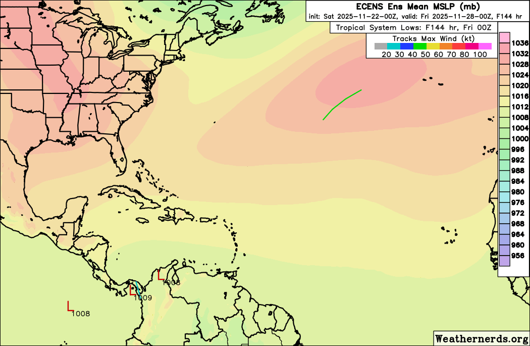
A little bit of noise on the Euro ensembles:
1 likes
TC naming lists: retirements and intensity
Most aggressive Advisory #1's in North Atlantic (cr. kevin for starting the list)
Most aggressive Advisory #1's in North Atlantic (cr. kevin for starting the list)
-
StormWeather

- Category 1

- Posts: 472
- Joined: Wed Jun 05, 2024 2:34 pm
Re: 2025 Global Model Runs Discussion (Out thru day 16)
Teban54 wrote:A little bit of noise on the Euro ensembles:
https://i.postimg.cc/gJ0RSbd1/15480045.gif
That would be interesting if it verified.
2025 doing 2025 things (December storm why not?)
0 likes
Just an average cyclone tracker
The posts in this forum are NOT official forecasts and should not be used as such. They are just the opinion of the poster and may or may not be backed by sound meteorological data. They are NOT endorsed by any professional institution or storm2k.org. For official information, please refer to the NHC and NWS products
The posts in this forum are NOT official forecasts and should not be used as such. They are just the opinion of the poster and may or may not be backed by sound meteorological data. They are NOT endorsed by any professional institution or storm2k.org. For official information, please refer to the NHC and NWS products
-
MGC

- S2K Supporter
- Posts: 5937
- Joined: Sun Mar 23, 2003 9:05 pm
- Location: Pass Christian MS, or what is left.
Re: 2025 Global Model Runs Discussion (Out thru day 16)
No US landfall in 2025?? GFS: Hold my whiskey bottle. If this verifies it would be unpresented, a landfalling hurricane on the north gulf in December?......Nope!.....MGC
0 likes

Re: 2025 Global Model Runs Discussion (Out thru day 16)
Didn't have a December landfall on my bingo card!

1 likes
-
Category5Kaiju

- Category 5

- Posts: 4300
- Joined: Thu Dec 24, 2020 12:45 pm
- Location: Seattle and Phoenix
Re: 2025 Global Model Runs Discussion (Out thru day 16)
I'm going to go out on a limb here and say that I personally don't think said storm is going to happen and that it's a ghost storm.
With that being said....it would be the ultimate troll move if 2025 managed to do something like that. We're in a -ENSO, the Caribbean is still 28 C, so....I guess it's technically not impossible? But likely? Heck no.
With that being said....it would be the ultimate troll move if 2025 managed to do something like that. We're in a -ENSO, the Caribbean is still 28 C, so....I guess it's technically not impossible? But likely? Heck no.
1 likes
Unless explicitly stated, all info in my posts is based on my own opinions and observations. Tropical storms and hurricanes can be extremely dangerous. Refer to an accredited weather research agency or meteorologist if you need to make serious decisions regarding an approaching storm.
Re: 2025 Global Model Runs Discussion (Out thru day 16)
There were 24 Atlantic tropical and subtropical cyclones that existed in December (at TS strength or higher) in official HURDAT records (1851+), plus 1 unofficial Martinique-Venezuela hurricane in 1822. Of these:
- 11 formed in November and lasted into December while tropical or subtropical
- 1 existed in the Gulf of Mexico in December (1925 Florida TS)
- 7 existed in the Caribbean Sea in December
- 18 storms, a majority, existed in the open Atlantic in December (north of Greater Antilles, not counting Olga 2007), mostly in the subtropics
- 8 attained hurricane strength in December, all but one in the open Atlantic; all peaked at Category 1
- The minimum TC pressure recorded in December was 979 mb (Nicole 1998)
- Most intense Atlantic tropical cyclone in December
- The only TC to reach hurricane intensity in the Gulf in December
- The only Atlantic TC to make landfall as a hurricane in December, in official records (not counting 1822)
- Northernmost landfall in the Atlantic in December
- Latest landfall in the US in a calendar year (2 days later than the 1925 TS)
- Possibly the latest Category 2 Atlantic hurricane in a calendar year, if it reaches such intensity (beating Otto 2016)
Last edited by Teban54 on Sat Nov 22, 2025 11:13 am, edited 7 times in total.
3 likes
TC naming lists: retirements and intensity
Most aggressive Advisory #1's in North Atlantic (cr. kevin for starting the list)
Most aggressive Advisory #1's in North Atlantic (cr. kevin for starting the list)
Re: 2025 Global Model Runs Discussion (Out thru day 16)
MGC wrote:No US landfall in 2025?? GFS: Hold my whiskey bottle. If this verifies it would be unpresented, a landfalling hurricane on the north gulf in December?......Nope!.....MGC
Something something Chantal
1 likes
TC naming lists: retirements and intensity
Most aggressive Advisory #1's in North Atlantic (cr. kevin for starting the list)
Most aggressive Advisory #1's in North Atlantic (cr. kevin for starting the list)
-
StormWeather
- Category 1
- Posts: 472
- Joined: Wed Jun 05, 2024 2:34 pm
Re: 2025 Global Model Runs Discussion (Out thru day 16)
Category5Kaiju wrote:I'm going to go out on a limb here and say that I personally don't think said storm is going to happen and that it's a ghost storm.
With that being said....it would be the ultimate troll move if 2025 managed to do something like that. We're in a -ENSO, the Caribbean is still 28 C, so....I guess it's technically not impossible? But likely? Heck no.
I mean unexpectedly, the AI models (which have done well this year) do have a bit of a signal, so it is something to watch and see.
1 likes
Just an average cyclone tracker
The posts in this forum are NOT official forecasts and should not be used as such. They are just the opinion of the poster and may or may not be backed by sound meteorological data. They are NOT endorsed by any professional institution or storm2k.org. For official information, please refer to the NHC and NWS products
The posts in this forum are NOT official forecasts and should not be used as such. They are just the opinion of the poster and may or may not be backed by sound meteorological data. They are NOT endorsed by any professional institution or storm2k.org. For official information, please refer to the NHC and NWS products
Re: 2025 Global Model Runs Discussion (Out thru day 16)
Category5Kaiju wrote:I'm going to go out on a limb here and say that I personally don't think said storm is going to happen and that it's a ghost storm.
I don' think you are really out on a limb
1 likes
-
Hurricane2022

- Category 5
- Posts: 1949
- Joined: Tue Aug 23, 2022 11:38 pm
- Location: Araçatuba, Brazil
Re: 2025 Global Model Runs Discussion (Out thru day 16)
2 likes
Sorry for the bad English sometimes...!
For reliable and detailed information for any meteorological phenomenon, please consult the National Hurricane Center, Joint Typhoon Warning Center , or your local Meteo Center.
--------
ECCE OMNIA NOVA FACIAM (Ap 21,5).
For reliable and detailed information for any meteorological phenomenon, please consult the National Hurricane Center, Joint Typhoon Warning Center , or your local Meteo Center.
--------
ECCE OMNIA NOVA FACIAM (Ap 21,5).
Re: 2025 Global Model Runs Discussion (Out thru day 16)
12z GFS, 3rd run in a row albeit much further west:
.gif)
More importantly, 12z EPS has a much stronger signal:
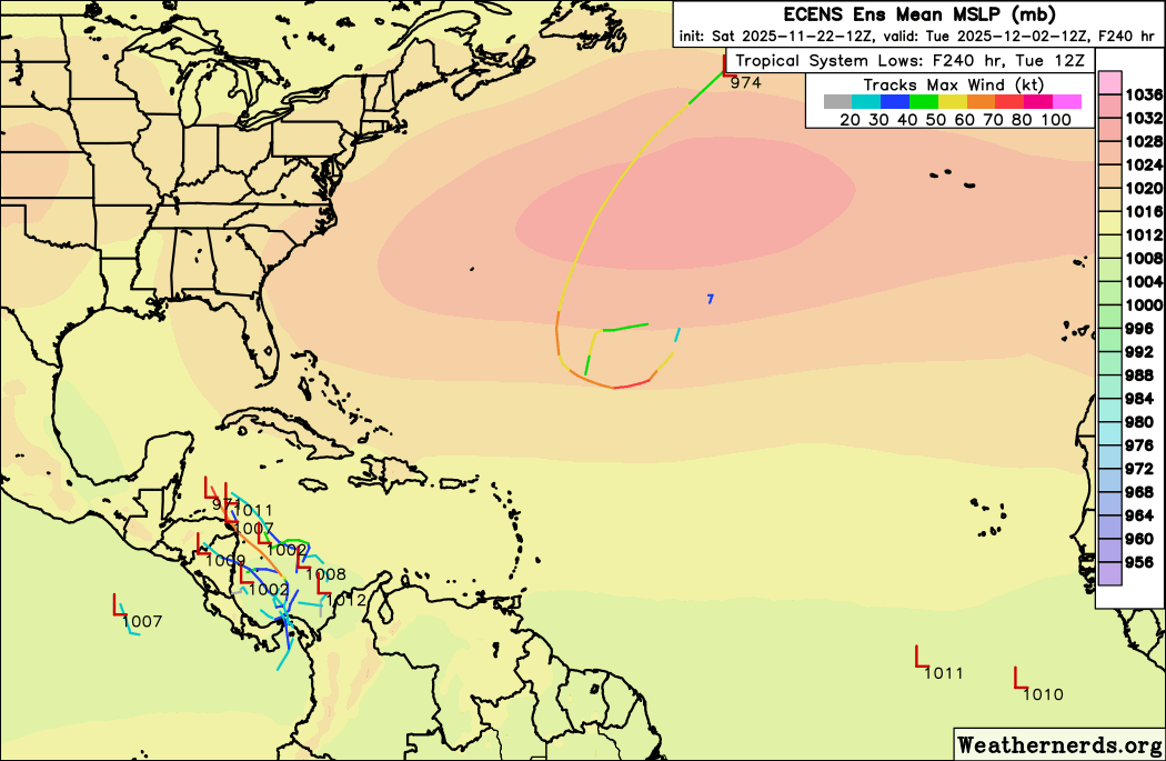
More importantly, 12z EPS has a much stronger signal:
1 likes
TC naming lists: retirements and intensity
Most aggressive Advisory #1's in North Atlantic (cr. kevin for starting the list)
Most aggressive Advisory #1's in North Atlantic (cr. kevin for starting the list)
-
StormWeather
- Category 1
- Posts: 472
- Joined: Wed Jun 05, 2024 2:34 pm
Re: 2025 Global Model Runs Discussion (Out thru day 16)
If this manages to become Nestor (if it even forms at all) then that would be ironic because the last storm to form in December was Subtropical Storm 15L of 2013, and funny enough, it formed in December and had it been named operationally it would have been named Nestor.
1 likes
Just an average cyclone tracker
The posts in this forum are NOT official forecasts and should not be used as such. They are just the opinion of the poster and may or may not be backed by sound meteorological data. They are NOT endorsed by any professional institution or storm2k.org. For official information, please refer to the NHC and NWS products
The posts in this forum are NOT official forecasts and should not be used as such. They are just the opinion of the poster and may or may not be backed by sound meteorological data. They are NOT endorsed by any professional institution or storm2k.org. For official information, please refer to the NHC and NWS products
Who is online
Users browsing this forum: No registered users and 70 guests