2026 ENSO Updates

This is the general tropical discussion area. Anyone can take their shot at predicting a storms path.

Moderator: S2k Moderators

Forum rules

The posts in this forum are NOT official forecasts and should not be used as such. They are just the opinion of the poster and may or may not be backed by sound meteorological data. They are NOT endorsed by any professional institution or STORM2K. For official information, please refer to products from the National Hurricane Center and National Weather Service.

Help Support Storm2K
Message
Author
User avatar
cycloneye
Admin
Admin
Posts: 148728
Age: 69
Joined: Thu Oct 10, 2002 10:54 am
Location: San Juan, Puerto Rico

Re: 2026 ENSO Updates

#101 Postby cycloneye » Sat Jan 10, 2026 11:16 am

Kingarabian wrote:Remains a potent WWB on the models. Looks like it'll start this week and likely continue until the end of the month.
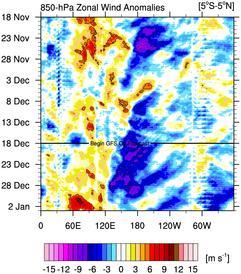

Image
0 likes   
Visit the Caribbean-Central America Weather Thread where you can find at first post web cams,radars
and observations from Caribbean basin members Click Here

User avatar
cycloneye
Admin
Admin
Posts: 148728
Age: 69
Joined: Thu Oct 10, 2002 10:54 am
Location: San Juan, Puerto Rico

Re: 2026 ENSO Updates

#102 Postby cycloneye » Sun Jan 11, 2026 3:56 pm

This upcomming WWB means business.


Eric Webb
@webberweather
Good lord.

This Westerly Wind Burst in the Tropical West Pacific late month is so strong on the Euro weeklies it's wrapping the scale

If there was any doubt we weren't getting an El Niño later this year, this just about does it.


 https://x.com/webberweather/status/2010446761731764416

1 likes   
Visit the Caribbean-Central America Weather Thread where you can find at first post web cams,radars
and observations from Caribbean basin members Click Here

User avatar
cycloneye
Admin
Admin
Posts: 148728
Age: 69
Joined: Thu Oct 10, 2002 10:54 am
Location: San Juan, Puerto Rico

Re: 2026 ENSO Updates

#103 Postby cycloneye » Sun Jan 11, 2026 4:31 pm

Andy Hazelton with the C35 multi-model.

@AndyHazelton
A solid majority of ensemble members from the C3S multi-model forecasts have a solid El Niño developing by early summer. The forecast looks comparable to or maybe even slightly warmer than the forecast from January 2023, and in reality ENSO verified on the warm side that time. The atmospheric coupling also appears to be well-established by then, with enhanced rising over the Pacific and enhanced shear/TUTT activity across the Atlantic.


 https://x.com/AndyHazelton/status/2010355273441890480

0 likes   
Visit the Caribbean-Central America Weather Thread where you can find at first post web cams,radars
and observations from Caribbean basin members Click Here

User avatar
cycloneye
Admin
Admin
Posts: 148728
Age: 69
Joined: Thu Oct 10, 2002 10:54 am
Location: San Juan, Puerto Rico

Re: 2026 ENSO Updates

#104 Postby cycloneye » Mon Jan 12, 2026 9:40 am

There are still mixed signals on ENSO today as the weekly CPC update is released. Niño 3.4 is more colder than last week at -0.8C and the 30 day SOI index continues very positive.

https://www.cpc.ncep.noaa.gov/products/ ... ts-web.pdf


Image

Image

On the other hand, the 300 meter depth is warming at a faster pace meaning the WWB is already having an effect on that.

Image
1 likes   
Visit the Caribbean-Central America Weather Thread where you can find at first post web cams,radars
and observations from Caribbean basin members Click Here

User avatar
cycloneye
Admin
Admin
Posts: 148728
Age: 69
Joined: Thu Oct 10, 2002 10:54 am
Location: San Juan, Puerto Rico

Re: 2026 ENSO Updates

#105 Postby cycloneye » Mon Jan 12, 2026 11:24 am

0 likes   
Visit the Caribbean-Central America Weather Thread where you can find at first post web cams,radars
and observations from Caribbean basin members Click Here

User avatar
Kingarabian
S2K Supporter
S2K Supporter
Posts: 16296
Joined: Sat Aug 08, 2009 3:06 am
Location: Honolulu, Hawaii

Re: 2026 ENSO Updates

#106 Postby Kingarabian » Mon Jan 12, 2026 2:11 pm

Interesting enough this MJO pulse won't be as strong as the ones we saw in 2014 and 2015 that superceded those strong WWBs. So there must be an additional precursor involved.
1 likes   
RIP Kobe Bryant

User avatar
Kingarabian
S2K Supporter
S2K Supporter
Posts: 16296
Joined: Sat Aug 08, 2009 3:06 am
Location: Honolulu, Hawaii

Re: 2026 ENSO Updates

#107 Postby Kingarabian » Mon Jan 12, 2026 2:12 pm

cycloneye wrote:There are still mixed signals on ENSO today as the weekly CPC update is released. Niño 3.4 is more colder than last week at -0.8C and the 30 day SOI index continues very positive.

https://www.cpc.ncep.noaa.gov/products/ ... ts-web.pdf


https://i.imgur.com/g6uUWyF.jpeg

https://i.imgur.com/sfzFCSP.jpeg

On the other hand, the 300 meter depth is warming at a faster pace meaning the WWB is already having an effect on that.

https://i.imgur.com/5Hvg2v7.jpeg


It'll start tanking in about a week or so but until the extra tropics lock in to +ENSO, expect some volatility.
2 likes   
RIP Kobe Bryant

User avatar
Yellow Evan
Professional-Met
Professional-Met
Posts: 16213
Age: 27
Joined: Fri Jul 15, 2011 12:48 pm
Location: Henderson, Nevada/Honolulu, HI
Contact:

Re: 2026 ENSO Updates

#108 Postby Yellow Evan » Mon Jan 12, 2026 2:24 pm

SOI isn't the best ENSO indicator with how off equatorial the index is based off of and not sure why this forum talks about it so much in the year of our lord 2026. The fundamentals of ENSO haven't really changed over the last week with a WPAC WWB still modeled, budding +PMM, classic pre-Nino sub-surface, and fairly cool Atlantic and Indian Ocean.
0 likes   

User avatar
cycloneye
Admin
Admin
Posts: 148728
Age: 69
Joined: Thu Oct 10, 2002 10:54 am
Location: San Juan, Puerto Rico

Re: 2026 ENSO Updates

#109 Postby cycloneye » Mon Jan 12, 2026 5:15 pm

The blues keep shrinking.

Image
0 likes   
Visit the Caribbean-Central America Weather Thread where you can find at first post web cams,radars
and observations from Caribbean basin members Click Here


Return to “Talkin' Tropics”

Who is online

Users browsing this forum: Teban54 and 67 guests