@BenNollWeather
If twin tropical cyclones form in the West Pacific in April, 2026 would be in a class with 2015 and 1997 — previous super El Niño events.
In March 2015 (left), Cyclones Pam and Bavi were twins, fueling a major westerly wind burst.
The same thing could happen in 2026 (right).
https://x.com/BenNollWeather/status/2037537628934078851
2026 ENSO Updates: BoM announces La Niña has ended
Moderator: S2k Moderators
Forum rules

The posts in this forum are NOT official forecasts and should not be used as such. They are just the opinion of the poster and may or may not be backed by sound meteorological data. They are NOT endorsed by any professional institution or STORM2K. For official information, please refer to products from the National Hurricane Center and National Weather Service.
-
cycloneye

- Admin

- Posts: 149478
- Age: 69
- Joined: Thu Oct 10, 2002 10:54 am
- Location: San Juan, Puerto Rico
Re: 2026 ENSO Updates
2 likes
Visit the Caribbean-Central America Weather Thread where you can find at first post web cams,radars
and observations from Caribbean basin members Click Here
and observations from Caribbean basin members Click Here
-
mixedDanilo.E
- Tropical Storm

- Posts: 117
- Joined: Sun Nov 21, 2021 8:00 am
- Location: NY
Re: 2026 ENSO Updates

This is incredible, very much like the WWB we saw in 2015/1997. If this verifies, Strong El Nino here we come.
4 likes
-
dexterlabio
- Category 5

- Posts: 3507
- Joined: Sat Oct 24, 2009 11:50 pm
Re: 2026 ENSO Updates
I saw posts saying that this could be a west-based or Modoki event, but I always thought west-based El Niño events are typically the weak ones (<1.0C). With the WWB signal we are seeing now, I don't think this will be a weak event.
0 likes
Personal Forecast Disclaimer:
The posts in this forum are NOT official forecast and should not be used as such. They are just the opinion of the poster and may or may not be backed by sound meteorological data. They are NOT endorsed by any professional institution or storm2k.org. For official information, please refer to the NHC and NWS products.
The posts in this forum are NOT official forecast and should not be used as such. They are just the opinion of the poster and may or may not be backed by sound meteorological data. They are NOT endorsed by any professional institution or storm2k.org. For official information, please refer to the NHC and NWS products.
-
cycloneye
- Admin
- Posts: 149478
- Age: 69
- Joined: Thu Oct 10, 2002 10:54 am
- Location: San Juan, Puerto Rico
Re: 2026 ENSO Updates

4 likes
Visit the Caribbean-Central America Weather Thread where you can find at first post web cams,radars
and observations from Caribbean basin members Click Here
and observations from Caribbean basin members Click Here
-
cycloneye
- Admin
- Posts: 149478
- Age: 69
- Joined: Thu Oct 10, 2002 10:54 am
- Location: San Juan, Puerto Rico
Re: 2026 ENSO Updates
Very interesting information here about the effects from Tropical Cyclones on ENSO as there is a possibility that twin tropical cyclones (one on each side of the equator) may develop if the models are right.
https://journals.ametsoc.org/view/journ ... 0821.1.xml
https://journals.ametsoc.org/view/journ ... 0821.1.xml
4 likes
Visit the Caribbean-Central America Weather Thread where you can find at first post web cams,radars
and observations from Caribbean basin members Click Here
and observations from Caribbean basin members Click Here
-
cycloneye
- Admin
- Posts: 149478
- Age: 69
- Joined: Thu Oct 10, 2002 10:54 am
- Location: San Juan, Puerto Rico
Re: 2026 ENSO Updates
The plot keeps thickening as the trend toward El Niño continues. The graphic and loop speak for themselves.


3 likes
Visit the Caribbean-Central America Weather Thread where you can find at first post web cams,radars
and observations from Caribbean basin members Click Here
and observations from Caribbean basin members Click Here
-
cycloneye
- Admin
- Posts: 149478
- Age: 69
- Joined: Thu Oct 10, 2002 10:54 am
- Location: San Juan, Puerto Rico
Re: 2026 ENSO Updates

1 likes
Visit the Caribbean-Central America Weather Thread where you can find at first post web cams,radars
and observations from Caribbean basin members Click Here
and observations from Caribbean basin members Click Here
-
cycloneye
- Admin
- Posts: 149478
- Age: 69
- Joined: Thu Oct 10, 2002 10:54 am
- Location: San Juan, Puerto Rico
Re: 2026 ENSO Updates
CPC 3/30/26 weekly update has niño 3.4 up to -0.3C at neutral.
https://www.cpc.ncep.noaa.gov/products/ ... ts-web.pdf

https://www.cpc.ncep.noaa.gov/products/ ... ts-web.pdf
1 likes
Visit the Caribbean-Central America Weather Thread where you can find at first post web cams,radars
and observations from Caribbean basin members Click Here
and observations from Caribbean basin members Click Here


Re: 2026 ENSO Updates
No longer just a forecast, but the stronger anomalies are verifying.

7 likes
The above post and any post by Ntxw is NOT an official forecast and should not be used as such. It is just the opinion of the poster and may or may not be backed by sound meteorological data. It is NOT endorsed by any professional institution including Storm2k. For official information, please refer to NWS products.
Help support Storm2K!
-
cycloneye
- Admin
- Posts: 149478
- Age: 69
- Joined: Thu Oct 10, 2002 10:54 am
- Location: San Juan, Puerto Rico
Re: 2026 ENSO Updates
cycloneye wrote:Kingarabian, look at the SOI falling fast now.
https://www.longpaddock.qld.gov.au/soi/
https://i.imgur.com/SzxN5vc.jpeg
Is almost in crash mode.

5 likes
Visit the Caribbean-Central America Weather Thread where you can find at first post web cams,radars
and observations from Caribbean basin members Click Here
and observations from Caribbean basin members Click Here
-
cycloneye
- Admin
- Posts: 149478
- Age: 69
- Joined: Thu Oct 10, 2002 10:54 am
- Location: San Juan, Puerto Rico
Re: 2026 ENSO Updates
0 likes
Visit the Caribbean-Central America Weather Thread where you can find at first post web cams,radars
and observations from Caribbean basin members Click Here
and observations from Caribbean basin members Click Here

Re: 2026 ENSO Updates
Interestingly is that the traditional NWP models like GFS and Euro have weakened the potential of this possible TC in the latest runs while Euro AI and Deepmind continue to show a significant system
1 likes
ヤンデレ女が寝取られるているのを見たい!!!
ECMWF ensemble NWPAC plots: https://ecmwfensnwpac.imgbb.com/
Multimodel NWPAC plots: https://multimodelnwpac.imgbb.com/
GFS Ensemble NWPAC plots (16 & 35 day forecast): https://gefsnwpac.imgbb.com/
Plots updated automatically
ECMWF ensemble NWPAC plots: https://ecmwfensnwpac.imgbb.com/
Multimodel NWPAC plots: https://multimodelnwpac.imgbb.com/
GFS Ensemble NWPAC plots (16 & 35 day forecast): https://gefsnwpac.imgbb.com/
Plots updated automatically
-
cycloneye
- Admin
- Posts: 149478
- Age: 69
- Joined: Thu Oct 10, 2002 10:54 am
- Location: San Juan, Puerto Rico
Re: 2026 ENSO Updates: Breaking News=BoM announces La Niña has ended
The first shoe has dropped and is from the BoM of Australia.

https://www.bom.gov.au/climate/enso/?ni ... s=Overview
https://www.bom.gov.au/climate/enso/?ni ... s=Overview
1 likes
Visit the Caribbean-Central America Weather Thread where you can find at first post web cams,radars
and observations from Caribbean basin members Click Here
and observations from Caribbean basin members Click Here
-
mixedDanilo.E
- Tropical Storm
- Posts: 117
- Joined: Sun Nov 21, 2021 8:00 am
- Location: NY
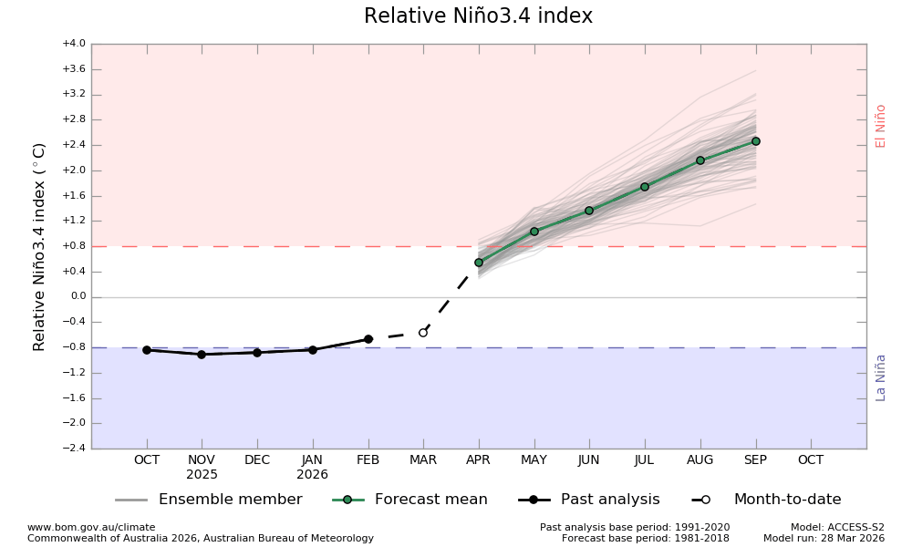
Re: 2026 ENSO Updates: Breaking News=BoM announces La Niña has ended
cycloneye wrote:The first shoe has dropped and is from the BoM of Australia.
https://i.imgur.com/SNR3rQQ.jpeg
https://www.bom.gov.au/climate/ocean/outlooks/archive/20260328//plumes/sstOutlooks.rnino34.hr.png
https://www.bom.gov.au/climate/enso/?ni ... s=Overview
I'm not gonna lie to you, even though strong El Nino is looking more likely, I have a hard time believing we will get as as strong as the BoM forecasts, especially by September. What especially makes me want to partially throw this run out is a HUGE jump in the index from March to April. I'm sorry but I do not see that happening.
0 likes
-
DorkyMcDorkface

- Category 5
- Posts: 1013
- Age: 28
- Joined: Mon Sep 30, 2019 1:32 pm
- Location: Mid-Atlantic
Re: 2026 ENSO Updates: BoM announces La Niña has ended
New April CanSIPS is a little stronger with the Niño but still stubbornly favors the Central Pacific-based look from prior runs rather than the more canonical east-based flavor the rest of the guidance has. It's been very persistent with this look, but again, it doesn't have much support from the rest of the seasonal guidance.

0 likes
Please note the thoughts expressed by this account are solely those of the user and are from a hobbyist perspective. For more comprehensive analysis, consult an actual professional meteorologist or meteorological agency.
Floyd 1999 | Isabel 2003 | Hanna 2008 | Irene 2011 | Sandy 2012 | Isaias 2020
-
Kingarabian

- S2K Supporter

- Posts: 16365
- Joined: Sat Aug 08, 2009 3:06 am
- Location: Honolulu, Hawaii
Re: 2026 ENSO Updates: BoM announces La Niña has ended
DorkyMcDorkface wrote:New April CanSIPS is a little stronger with the Niño but still stubbornly favors the Central Pacific-based look from prior runs rather than the more canonical east-based flavor the rest of the guidance has. It's been very persistent with this look, but again, it doesn't have much support from the rest of the seasonal guidance.
https://i.imgur.com/3ROuj6N.png
Also a neutral to negative PDO.
0 likes
RIP Kobe Bryant
Who is online
Users browsing this forum: hurricanes1234 and 162 guests