And eerily enough, I saw this sign on the roadways coming into work this morning:
Houston TranStar Dynamic Message Sign
I-610 North Loop Westbound at Jensen
Hurricane Season Is Here
Be Prepared....
NW Carribean / Southern GOM / BOC (Is invest 96L)
Moderator: S2k Moderators
Forum rules

The posts in this forum are NOT official forecasts and should not be used as such. They are just the opinion of the poster and may or may not be backed by sound meteorological data. They are NOT endorsed by any professional institution or STORM2K. For official information, please refer to products from the National Hurricane Center and National Weather Service.
-
Tireman4

- S2K Supporter

- Posts: 5903
- Age: 60
- Joined: Fri Jun 30, 2006 1:08 pm
- Location: Humble, Texas
- Contact:
Re: Bay of Campeche
0 likes

-
cycloneye

- Admin

- Posts: 149275
- Age: 69
- Joined: Thu Oct 10, 2002 10:54 am
- Location: San Juan, Puerto Rico
Re:
bilhhh wrote:Thanks, Mod. That explains it well. Good to hear from you.
No problem. Welcome to Storm2k and if you have any questions,I am sure you will get the answer.
0 likes
Visit the Caribbean-Central America Weather Thread where you can find at first post web cams,radars
and observations from Caribbean basin members Click Here
and observations from Caribbean basin members Click Here
-
Rgv20

- S2K Supporter
- Posts: 2466
- Age: 39
- Joined: Wed Jan 05, 2011 5:42 pm
- Location: Edinburg/McAllen Tx
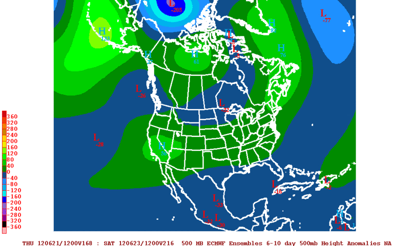
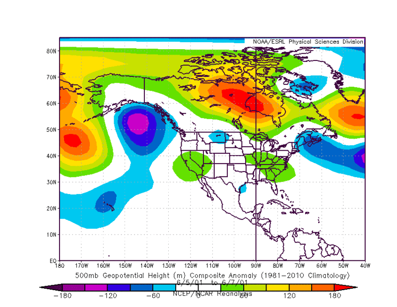
Looking at all the available guidance and ensemble models if something were to form in the BOC it looks like its going to be a very very slow moving system. Below is the 12ECMWF Ensemble 500mb Height Anomalies for days 6-10 and a very good analog day from June 2001......That was when TS Allison did some catastrophic flooding in the Houston area. It is still a long ways off but someone in the Western Gulf Coast to Louisiana could be in for some crazy rainfall totals as we head at the end of next week to next weekend.
12zECMWF Ensembles 500mb Height Anomalies for days 6-10.
500mb Height Anomaly from June 5-June 7 2001. TS Allison
12zECMWF Ensembles 500mb Height Anomalies for days 6-10.
500mb Height Anomaly from June 5-June 7 2001. TS Allison
0 likes
The following post is NOT an official forecast and should not be used as such. It is just the opinion of the poster and may or may not be backed by sound meteorological data. It is NOT endorsed by any professional institution including storm2k.org For Official Information please refer to the NHC and NWS products.
-
Rgv20
- S2K Supporter
- Posts: 2466
- Age: 39
- Joined: Wed Jan 05, 2011 5:42 pm
- Location: Edinburg/McAllen Tx
0zGFS has a TC just to the SE of Brownsville by Friday morning....Its going to be an interesting days ahead!
0 likes
The following post is NOT an official forecast and should not be used as such. It is just the opinion of the poster and may or may not be backed by sound meteorological data. It is NOT endorsed by any professional institution including storm2k.org For Official Information please refer to the NHC and NWS products.
-
Rgv20
- S2K Supporter
- Posts: 2466
- Age: 39
- Joined: Wed Jan 05, 2011 5:42 pm
- Location: Edinburg/McAllen Tx
0zGFS Ensemble Means have the TC about 150 miles South of the Operational GFS by Friday Morning.
0 likes
The following post is NOT an official forecast and should not be used as such. It is just the opinion of the poster and may or may not be backed by sound meteorological data. It is NOT endorsed by any professional institution including storm2k.org For Official Information please refer to the NHC and NWS products.

Re: Bay of Campeche
From this mornings Corpus Christi AFD:
ALL GUIDANCE IS INDICATING A SURGE OF DEEP
TROPICAL MOISTURE TOWARDS S TX LATE NEXT WEEK AS BROAD LOW PRESSURE
DEVELOPS IN THE BAY OF CAMPECHE. 00Z GUIDANCE SUITES ARE ALL
BRINGING THE SYSTEM/DISTURBANCE A LITTLE FARTHER NORTH AND A LITTLE
MORE ORGANIZED THAN PREVIOUS RUNS WHICH MAY LEAD TO INCREASING RAIN
CHANCES FOR ESPECIALLY THE SOUTHERN AND EASTERN CWA /AND ADJACENT
MARINE AREAS/. FOR NOW WILL GO WITH CHANCE POPS FOR WED AND THURS.
SYSTEM NEXT WEEK BEARS WATCHING.
0 likes
The following post is NOT an official forecast and should not be used as such. It is just the opinion of the poster and may or may not be backed by sound meteorological data. It is NOT endorsed by any professional institution including storm2k.org For Official Information please refer to the NHC and NWS products.
-
somethingfunny

- ChatStaff

- Posts: 3926
- Age: 37
- Joined: Thu May 31, 2007 10:30 pm
- Location: McKinney, Texas
Re: Bay of Campeche
Bears watching?

0 likes
I am not a meteorologist, and any posts made by me are not official forecasts or to be interpreted as being intelligent. These posts are just my opinions and are probably silly opinions.
-
cycloneye
- Admin
- Posts: 149275
- Age: 69
- Joined: Thu Oct 10, 2002 10:54 am
- Location: San Juan, Puerto Rico
Re: Bay of Campeche
From Houston/Galveston NWS:
LONGER RANGE BEGINNING TO LOOK WET. WEAKNESS/EASTERLY WAVE ON THE
SOUTH SIDE OF THE MEAN SFC-700MB HIGH OVER THE SOUTHEASTERN US
EARLY NEXT WEEK WILL MOVE TOWARDS SE TEXAS. WEAK UPPER TROF AT
500-250MB REMAINS CLOSE BY AS WELL. AHEAD OF THE SFC FEATURE PWATS
CLIMB AND SE TX IN FAVORABLE LOCATION FOR LIFT SO 30/40 PERCENT
POPS SEEM PRUDENT. BOTH GFS AND EXPERIMENTAL ECMWF MOS RAISE POPS
FURTHER FOR MIDWEEK IN RESPONSE TO INCREASED ONSHORE FLOW FROM
POSSIBLE TROPICAL DEVELOPMENT IN BAY OF CAMPECHE. STILL WAY TOO
EARLY TO GET TOO EXCITED ABOUT THIS POSSIBLE DEVELOPMENT BUT STILL
TOO FAR OUT (LATE NEXT WEEK!) TO FINE TUNE TIMING OR LOCATIONS SO
BROAD BRUSH APPROACH SEEMS BEST FOR NOW. GFS RAISES PWAT VALUES
TREMENDOUSLY WHILE ECMWF IS MORE RESTRAINED. WENT GENERALLY WITH A
2 PARTS ECM AND 1 PART GFS BLEND IN THE EXTENDED.
0 likes
Visit the Caribbean-Central America Weather Thread where you can find at first post web cams,radars
and observations from Caribbean basin members Click Here
and observations from Caribbean basin members Click Here
-
Rgv20
- S2K Supporter
- Posts: 2466
- Age: 39
- Joined: Wed Jan 05, 2011 5:42 pm
- Location: Edinburg/McAllen Tx
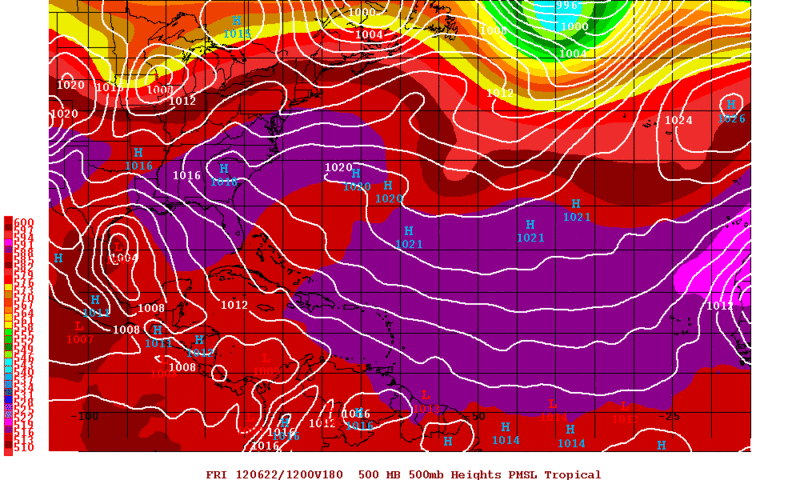
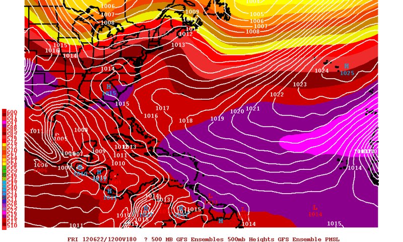
The GFS has been so consistent this past few runs.....6zGFS develops the BOC disturbance a little bit later in the forecast (About a day) which seems more reasonable solution. 0zECMWF still tries to develop something but its so close to the Mexican coast that it does not have any time to do anything.
06zGFS Forecast Valid for Thursday Evening
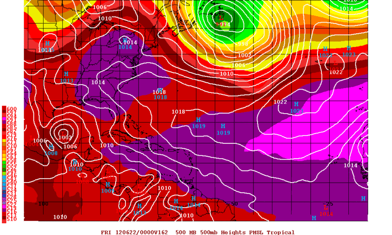
0zECMWF Forecast Valid for Thursday Evening
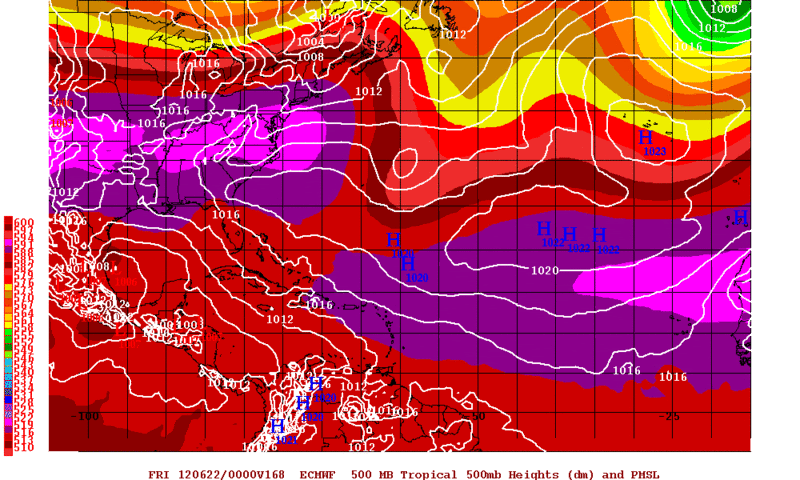
06zGFS Forecast Valid for Thursday Evening
0zECMWF Forecast Valid for Thursday Evening
0 likes
The following post is NOT an official forecast and should not be used as such. It is just the opinion of the poster and may or may not be backed by sound meteorological data. It is NOT endorsed by any professional institution including storm2k.org For Official Information please refer to the NHC and NWS products.
-
Rgv20
- S2K Supporter
- Posts: 2466
- Age: 39
- Joined: Wed Jan 05, 2011 5:42 pm
- Location: Edinburg/McAllen Tx
From the NWS in Brownsville early morning discussion.
THE NEXT FEATURE OF NOTE IS THE AREA OF SFC LOW PRESSURE
THAT ALL MODELS ARE TRYING TO WRAP UP IN THE BAY OF CAMPECHE LATE
WEEK AND DRIFT NORTHWARD ALONG THE FAR WESTERN GULF COAST.
WHILE THE MODELS MAKE THIS FEATURE LOOK EXCITING...IT IT WAY TOO
EARLY TO IMPLY ANYTHING TROPICAL OUT OF THIS FEATURE OR TO NAIL
DOWN THE TIMING OR LOCATION OF THIS FEATURE 8 DAYS OUT.
0 likes
The following post is NOT an official forecast and should not be used as such. It is just the opinion of the poster and may or may not be backed by sound meteorological data. It is NOT endorsed by any professional institution including storm2k.org For Official Information please refer to the NHC and NWS products.
-
Rgv20
- S2K Supporter
- Posts: 2466
- Age: 39
- Joined: Wed Jan 05, 2011 5:42 pm
- Location: Edinburg/McAllen Tx
HPC Discussion
"MEANWHILE RECENT ENSEMBLE GUIDANCE HAS BEEN
SHOWING AN INCREASINGLY FAVORABLE ENVIRONMENT FOR PSBL TROPICAL
DEVELOPMENT FROM THE NWRN CARIBBEAN INTO THE WRN GULF OF MEXICO BY
THE LATTER HALF OF THE PERIOD. THERE IS GENERALLY SUFFICIENT
AGREEMENT WITH THE LARGE SCALE FLOW TO RECOMMEND A CONSENSUS
APPROACH TO THE FCST."
0 likes
The following post is NOT an official forecast and should not be used as such. It is just the opinion of the poster and may or may not be backed by sound meteorological data. It is NOT endorsed by any professional institution including storm2k.org For Official Information please refer to the NHC and NWS products.
-
Aric Dunn
- Category 5

- Posts: 21238
- Age: 43
- Joined: Sun Sep 19, 2004 9:58 pm
- Location: Ready for the Chase.
- Contact:
12z GFS 100 hours.. nothing in the BOC. quite different from 00z.
0 likes
Note: If I make a post that is brief. Please refer back to previous posts for the analysis or reasoning. I do not re-write/qoute what my initial post said each time.
If there is nothing before... then just ask
Space & Atmospheric Physicist, Embry-Riddle Aeronautical University,
I believe the sky is falling...
If there is nothing before... then just ask
Space & Atmospheric Physicist, Embry-Riddle Aeronautical University,
I believe the sky is falling...
-
Rgv20
- S2K Supporter
- Posts: 2466
- Age: 39
- Joined: Wed Jan 05, 2011 5:42 pm
- Location: Edinburg/McAllen Tx
EDIT:12zGFS Starts developing the low on Wednesday Morning.
Last edited by Rgv20 on Fri Jun 15, 2012 11:15 am, edited 1 time in total.
0 likes
The following post is NOT an official forecast and should not be used as such. It is just the opinion of the poster and may or may not be backed by sound meteorological data. It is NOT endorsed by any professional institution including storm2k.org For Official Information please refer to the NHC and NWS products.
-
Aric Dunn
- Category 5
- Posts: 21238
- Age: 43
- Joined: Sun Sep 19, 2004 9:58 pm
- Location: Ready for the Chase.
- Contact:
Re:
Rgv20 wrote::uarrow: So far is following the 06zGFS which started development around Wednesday....IMO 0z was a tad to fast.
actually its still different in a sense. run the loop its actually the SW carrib low that crosses the yucatan in the boc.
http://mag.ncep.noaa.gov/NCOMAGWEB/appc ... mageSize=M
0 likes
Note: If I make a post that is brief. Please refer back to previous posts for the analysis or reasoning. I do not re-write/qoute what my initial post said each time.
If there is nothing before... then just ask
Space & Atmospheric Physicist, Embry-Riddle Aeronautical University,
I believe the sky is falling...
If there is nothing before... then just ask
Space & Atmospheric Physicist, Embry-Riddle Aeronautical University,
I believe the sky is falling...


I'm starting to buy into idea of a BOC entity. Whether it be from SW Carib, EPAC or monsoonal trough (heck even all three combined) high pressure over Appalachia and the SE will definitely steer it to the western gulf next week. A faster solution would slip it to the central gulf imo.
0 likes
The above post and any post by Ntxw is NOT an official forecast and should not be used as such. It is just the opinion of the poster and may or may not be backed by sound meteorological data. It is NOT endorsed by any professional institution including Storm2k. For official information, please refer to NWS products.
Help support Storm2K!
-
PTrackerLA

- Category 5
- Posts: 5281
- Age: 42
- Joined: Thu Oct 10, 2002 8:40 pm
- Location: Lafayette, LA
-
Aric Dunn
- Category 5
- Posts: 21238
- Age: 43
- Joined: Sun Sep 19, 2004 9:58 pm
- Location: Ready for the Chase.
- Contact:
Re:
PTrackerLA wrote:Looks like a decent sized trough coming down on the 12z GFS could be taking this low further up the Texas coast this run?
189 hours. notice the moisture in the central gulf its heading off to the NE. trough passed it by it seems but did bring it farther north.
But that really far down the road. may not get anything at all.

0 likes
Note: If I make a post that is brief. Please refer back to previous posts for the analysis or reasoning. I do not re-write/qoute what my initial post said each time.
If there is nothing before... then just ask
Space & Atmospheric Physicist, Embry-Riddle Aeronautical University,
I believe the sky is falling...
If there is nothing before... then just ask
Space & Atmospheric Physicist, Embry-Riddle Aeronautical University,
I believe the sky is falling...


-
'CaneFreak

- Category 5
- Posts: 1487
- Joined: Mon Jun 05, 2006 10:50 am
- Location: New Bern, NC
beginning to think this is all a bunch of model nonsense  This happens a lot early in the season as the convective scheme of these models spins up a lot of these "phantom" storms and it draws all kinds of attention but ends up being nothing much of anything. With that said, don't take your eyes off of it but at the same time, don't get too surprised if nothing happens. This happens every season year in and year out.

0 likes
Who is online
Users browsing this forum: Majestic-12 [Bot] and 122 guests