Disturbed Weather in NW Gulf/Texas
Moderator: S2k Moderators
Forum rules

The posts in this forum are NOT official forecasts and should not be used as such. They are just the opinion of the poster and may or may not be backed by sound meteorological data. They are NOT endorsed by any professional institution or STORM2K. For official information, please refer to products from the National Hurricane Center and National Weather Service.
-
stormreader
Re: NW Carib Flare-Up
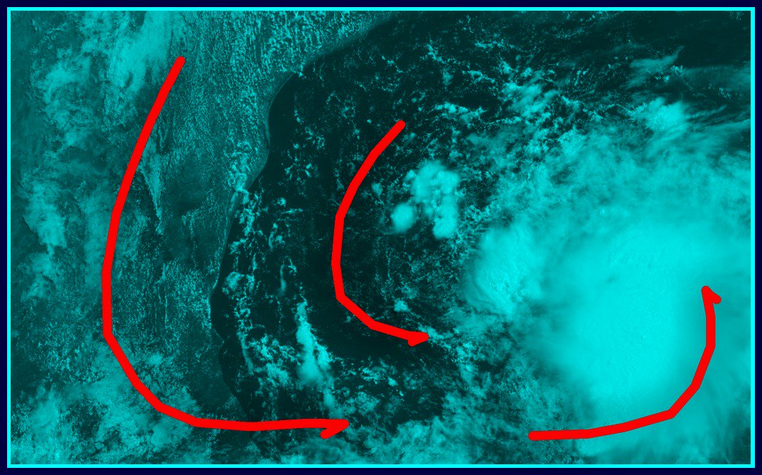
No discernible organization. T-storms beginning to pop now further north and west of the Yucatan. Looks like the disorganized area is really beginning to enter the Gulf of Mexico. No longer really a NW Carib Flare-Up as the thread title says.!
0 likes


-
Clearcloudz

- Category 2

- Posts: 540
- Joined: Sun Jun 10, 2018 1:46 pm
- Location: Rosenberg TX
Re: NW Carib Flare-Up
Haris wrote:the fact nam is going to icon and their entire camp makes me soo anxious ! model war !!!!
RGEM like give me some love out here as well for going with the NAM and ICON solutions as well.

0 likes

Re: NW Carib Flare-Up
Definitely deserves an invest number and a percentage raise at 2pm.
1 likes
Igor 2010, Sandy 2012, Fay 2014, Gonzalo 2014, Joaquin 2015, Nicole 2016, Humberto 2019, Imelda 2025
I am only a tropical weather enthusiast. My predictions are not official and may or may not be backed by sound meteorological data. For official information, please refer to the NHC and NWS products.
I am only a tropical weather enthusiast. My predictions are not official and may or may not be backed by sound meteorological data. For official information, please refer to the NHC and NWS products.
-
cycloneye

- Admin

- Posts: 149355
- Age: 69
- Joined: Thu Oct 10, 2002 10:54 am
- Location: San Juan, Puerto Rico
Re: NW Carib Flare-Up
We have the guideline about the changing of title to reflect a new location.
If you start a thread about an area of disturbed weather, you MUST take on the responsibility of keeping the thread title current and representative with respect to location, intensity, etc.
viewtopic.php?f=31&t=118093&p=2583352#p2583352
If you start a thread about an area of disturbed weather, you MUST take on the responsibility of keeping the thread title current and representative with respect to location, intensity, etc.
viewtopic.php?f=31&t=118093&p=2583352#p2583352
0 likes
Visit the Caribbean-Central America Weather Thread where you can find at first post web cams,radars
and observations from Caribbean basin members Click Here
and observations from Caribbean basin members Click Here
-
jasons2k

- Storm2k Executive
- Posts: 8290
- Age: 52
- Joined: Wed Jul 06, 2005 12:32 pm
- Location: The Woodlands, TX
Re: NW Carib Flare-Up
12Z GFS has rains moving inland over SE Texas tomorrow, and no closed low thru 42 hours.
2 likes
-
cycloneye
- Admin
- Posts: 149355
- Age: 69
- Joined: Thu Oct 10, 2002 10:54 am
- Location: San Juan, Puerto Rico
Re: NW Carib Flare-Up
Houston/Galveston area is in the bullseye on 12z GFS with plenty of rain.
1 likes
Visit the Caribbean-Central America Weather Thread where you can find at first post web cams,radars
and observations from Caribbean basin members Click Here
and observations from Caribbean basin members Click Here

Re: NW Carib Flare-Up
I suspect an invest tag soon. Looks to good even if it’s mid level...reminds me of Humberto..same crap mid level then BAM LLC and strengthens along the coast...
2 likes
-
cycloneye
- Admin
- Posts: 149355
- Age: 69
- Joined: Thu Oct 10, 2002 10:54 am
- Location: San Juan, Puerto Rico
Re: Disturbed Weather in Gulf
Thanks stormreader for editing the title.
0 likes
Visit the Caribbean-Central America Weather Thread where you can find at first post web cams,radars
and observations from Caribbean basin members Click Here
and observations from Caribbean basin members Click Here
Re: Disturbed Weather in Gulf
Looks like the mid level toaation has tucked back under some tstorms to the NW...hope no one gets undressed if this does blow up..js
1 likes
-
Clearcloudz
- Category 2
- Posts: 540
- Joined: Sun Jun 10, 2018 1:46 pm
- Location: Rosenberg TX
-
Clearcloudz
- Category 2
- Posts: 540
- Joined: Sun Jun 10, 2018 1:46 pm
- Location: Rosenberg TX
Re: Disturbed Weather in Gulf
Travis Herzog ABC 13
See full post in the link below
https://www.facebook.com/ABC13TravisHerzog/
TROPICAL UPDATE 10:30AM SATURDAY:
Prepare for a lot of mischief in the Gulf this week.
Name or no name, this tropical weather system will most likely bring the impacts of a tropical storm to the Texas coastline in a few days.
All week long we were tracking a poorly organized tropical wave that at one time a computer model predicted would turn into a category 3 hurricane. Instead, it fizzled yesterday over the western Gulf.
Now we have a new tropical wave flaring up (see my posts from yesterday), and this one is a legitimate tropical threat to our coastline.
As of this writing, the National Hurricane Center only gives it a 10% chance of forming into a tropical depression or a tropical storm. I think the chances are actually much higher than that, but it's almost a moot point because the impacts will essentially be the same: Several inches of rain into Texas, winds along the coast gusting above 50 mph, and minor coastal flooding from the wind-driven tide known as a surge.
I do not think the computer models have a good handle on this situation, so please stay weather aware during the weekend.
Here's what I expect to happen today:
1.) The current flare up of storms will wane some. If new storms start to fire up again late this afternoon or early this evening, that's a strong signal it will attempt to develop into something more.
2.) Development will be slow to occur, despite how ominous the flare of up clouds may seem right now. I'll be looking to see if a low-level circulation starts to develop in the Gulf. Until one forms, development, if any, will be slow to occur.
3.) Additional resources from the National Hurricane Center. I also anticipate the National Hurricane Center will probably designate this as "Invest 92-L" and start running computer model simulations later today or tonight.
I want to stress that there is high uncertainty right now. Many of you are probably wondering if this thing could turn into a hurricane. My answer right now is probably not, but I can't rule anything out on this one just yet like I could with the last one. I hope to post again this evening, but first I want to see how the system evolves thru the afternoon and look at all the new computer model data coming in now as I type.
3 likes
-
Haris

- Category 5

- Posts: 1814
- Joined: Mon Nov 27, 2017 8:19 pm
- Location: ( Bee Cave) West Austin, Texas
Re: Disturbed Weather in Gulf
Whatever happens , todays 12z suite pummels TX with rain!!
gfs , cmc , nam etc...
Lotta rain
gfs , cmc , nam etc...
Lotta rain
1 likes
Weather geek and a storm spotter in West Austin. Not a degreed meteorologist. Big snow fan. Love rain and cold! Despise heat!

Re: Disturbed Weather in Gulf
Haris wrote:Whatever happens , todays 12z suite pummels TX with rain!!
gfs , cmc , nam etc...
Lotta rain
What are estimated rainfall amounts for the Greater Houston Area?
0 likes
Personal Forecast Disclaimer:
The posts in this forum are NOT official forecast and should not be used as such. They are just the opinion of the poster and may or may not be backed by sound meteorological data. They are NOT endorsed by any professional institution or storm2k.org. For official information, please refer to the NHC and NWS products.
The posts in this forum are NOT official forecast and should not be used as such. They are just the opinion of the poster and may or may not be backed by sound meteorological data. They are NOT endorsed by any professional institution or storm2k.org. For official information, please refer to the NHC and NWS products.
-
MississippiWx

- S2K Supporter

- Posts: 1720
- Joined: Sat Aug 14, 2010 1:44 pm
- Location: Hattiesburg, Mississippi
Re: Disturbed Weather in Gulf
This area looks nice on the outside but doesn’t have much under the hood yet. If it is able to close off a circulation it will be as it comes ashore in a couple of days. Long way to go still. Rain will be the main impact.
1 likes
This post is not an official forecast and should not be used as such. It is just the opinion of MississippiWx and may or may not be backed by sound meteorological data. It is not endorsed by any professional institution including storm2k.org. For Official Information please refer to the NHC and NWS products.
-
mcheer23

- Professional-Met

- Posts: 441
- Age: 32
- Joined: Sun Jun 24, 2012 8:24 pm
- Location: Sugar Land, Texas
Re: Disturbed Weather in Gulf
MississippiWx wrote:This area looks nice on the outside but doesn’t have much under the hood yet. If it is able to close off a circulation it will be as it comes ashore in a couple of days. Long way to go still. Rain will be the main impact.
Should be enough to warrant at least 20 percent from the NHC
0 likes
-
MississippiWx
- S2K Supporter
- Posts: 1720
- Joined: Sat Aug 14, 2010 1:44 pm
- Location: Hattiesburg, Mississippi
Re: Disturbed Weather in Gulf
mcheer23 wrote:MississippiWx wrote:This area looks nice on the outside but doesn’t have much under the hood yet. If it is able to close off a circulation it will be as it comes ashore in a couple of days. Long way to go still. Rain will be the main impact.
Should be enough to warrant at least 20 percent from the NHC
I’d say you are correct. It certainly has a small chance to form into a tropical cyclone, but their percentages don’t change the fact that it’s lacking reflection at the surface.
1 likes
This post is not an official forecast and should not be used as such. It is just the opinion of MississippiWx and may or may not be backed by sound meteorological data. It is not endorsed by any professional institution including storm2k.org. For Official Information please refer to the NHC and NWS products.

Re: Disturbed Weather in Gulf
Synopsis looks a little different this time.
Maybe we don't get fooled again?
Maybe we don't get fooled again?
0 likes
-
cycloneye
- Admin
- Posts: 149355
- Age: 69
- Joined: Thu Oct 10, 2002 10:54 am
- Location: San Juan, Puerto Rico
Re: Disturbed Weather in Gulf
Up to 20%-20%
Tropical Weather Outlook
NWS National Hurricane Center Miami FL
200 PM EDT Sat Jun 16 2018
For the North Atlantic...Caribbean Sea and the Gulf of Mexico:
Shower and thunderstorm activity associated with a surface trough
near the Yucatan Peninsula and an upper-level low over the western
Gulf of Mexico has increased in coverage since this morning. Recent
satellite-derived surface wind data indicate that a surface
circulation does not exist, but strong winds are occuring to the
north of the trough. Environmental conditions are not expected to
support significant development, however, heavy rains and gusty
winds are likely to spread across the central Gulf of Mexico today
and will reach portions of the Texas and southwestern Louisiana
coasts on Sunday. For more details on this system please see
products issued by your local weather office and High Seas Forecasts
issued by the National Weather Service.
* Formation chance through 48 hours...low...20 percent.
* Formation chance through 5 days...low...20 percent.
&&
High Seas Forecasts issued by the National Weather Service can be
found under AWIPS header NFDHSFAT1, WMO header FZNT01 KWBC, and
on the Web at https://ocean.weather.gov/shtml/NFDHSFAT1.shtml.
$$
Forecaster Zelinsky
1 likes
Visit the Caribbean-Central America Weather Thread where you can find at first post web cams,radars
and observations from Caribbean basin members Click Here
and observations from Caribbean basin members Click Here
Who is online
Users browsing this forum: chaser1 and 107 guests