Broad area of disturbed weather in the Western Caribbean Sea (Is INVEST 91L)
Moderator: S2k Moderators
Forum rules

The posts in this forum are NOT official forecasts and should not be used as such. They are just the opinion of the poster and may or may not be backed by sound meteorological data. They are NOT endorsed by any professional institution or STORM2K. For official information, please refer to products from the National Hurricane Center and National Weather Service.
-
toad strangler

- S2K Supporter

- Posts: 4546
- Joined: Sun Jul 28, 2013 3:09 pm
- Location: Earth
- Contact:
Re: Broad area of disturbed weather in the southwestern Caribbean Sea
More bird shot like vort splits on the 12z GFS through 168 hours. All over the place. Heavy sheer just to the N in then Caribbean, SE GOM, and FL straits. I can't see anything getting organized in this environment on the 12z GFS.
0 likes
My Weather Station
https://www.wunderground.com/dashboard/pws/KFLPORTS603
https://www.wunderground.com/dashboard/pws/KFLPORTS603

Re: Broad area of disturbed weather in the southwestern Caribbean Sea
The weakening shear axis is helping to support an organized upper divergence over the convection


0 likes

Re: Broad area of disturbed weather in the southwestern Caribbean Sea
12z CMC with a classic early October hurricane into the FL panhandle.
https://www.tropicaltidbits.com/analysis/models/?model=gem®ion=seus&pkg=mslp_pcpn&runtime=2018100112&fh=138
https://www.tropicaltidbits.com/analysis/models/?model=gem®ion=seus&pkg=mslp_pcpn&runtime=2018100112&fh=138
0 likes
-
stormlover2013
Re: Broad area of disturbed weather in the southwestern Caribbean Sea
It’s the cmc, horrible model hasn’t been good long range one bit
0 likes

Re: Broad area of disturbed weather in the southwestern Caribbean Sea
northjaxpro wrote:psyclone wrote:I'm watching this with interest as I always do down there this time of year but so far it's tough to bet against persistence which has been reliably hostile this season in the Caribbean. Toss in a scoop of nothin' (thus far) from the NHC and you have a model storm yawn fest at this point. But..tis the season and things change and the secondary peak (which reflects development in this region) is close at hand. It certainly warrants a periodic check in.
I am with you for the time being. Definitely we should always monitor the Northwestern Caribbean in early October for sure. However, as psyclone astutely indicated above, for the time being, conditions have been so hostile down there all season with shear and dry air. This has been persistent all season long in the Caribbean.
I am just waiting and seeing if the models indeed are picking up on potential improving upper and mid level conditions which could induce tropical cyclone development in the next week or so. Hopefully, we will have a better indication as time progresses later this week.
northjaxpro wrote:psyclone wrote:I'm watching this with interest as I always do down there this time of year but so far it's tough to bet against persistence which has been reliably hostile this season in the Caribbean. Toss in a scoop of nothin' (thus far) from the NHC and you have a model storm yawn fest at this point. But..tis the season and things change and the secondary peak (which reflects development in this region) is close at hand. It certainly warrants a periodic check in.
I am with you for the time being. Definitely we should always monitor the Northwestern Caribbean in early October for sure. However, as psyclone astutely indicated above, for the time being, conditions have been so hostile down there all season with shear and dry air. This has been persistent all season long in the Caribbean.
I am just waiting and seeing if the models indeed are picking up on potential improving upper and mid level conditions which coould induce tropical cyclone development in the next week or so. Hopefully, we will have a better indication as time progresses later this week.
Beat me to the punch lol; Was just about to chime in that for the most part, I think psyclone pretty well lays out my perspective on near to mid term development for the W. Caribbean. I do believe that the westward retrogresson of the cut-off low to the north of the potential suspect area, should help toward bending the harsh upper level flow some. I'm just not seeing any 200mb forecast maps thus far that really depict some evolution of a building upper anticyclone over the W. Caribbean.
I suspect that the less hostile upper level conditions in the far Southwest Caribbean in conjunction with the westward moving cut-off low helping to eventually induce a more northward outflow channel will provide adequate diffluence aloft for low pressure to develop. I'm sure NHC will begin referencing it in their TWO's by later tomorrow or early Wed. In general, a very large disturbance can certainly play a significant role toward building a hefty anticyclone over itself but that takes time. The extent that it may alter or overcome otherwise hostile westerly shear to it's north would be no small feat and probably need coincide with some shift of the longwave pattern over the Central U.S.
I may be slightly more bullish that a T.D. will develop out of this "Caribbean/Kirk Remnant Soup" then you two, but my thoughts pretty much align with yours regarding the unlikelihood of it becoming a potential hurricane threat to the U.S. Gulf coast or Florida. Could that change? Perhaps, but there'll need to be a good deal of time on "the game clock" for the broader upper level flow regime to really evolve for that to happen. "Maybe" in the 8-10 day period? Not sure if Kirk's remnants will have already moved on to it's Final Frontier" by that time though.
2 likes
Andy D
(For official information, please refer to the NHC and NWS products.)
(For official information, please refer to the NHC and NWS products.)
-
toad strangler
- S2K Supporter
- Posts: 4546
- Joined: Sun Jul 28, 2013 3:09 pm
- Location: Earth
- Contact:
Re: Broad area of disturbed weather in the southwestern Caribbean Sea
ronjon wrote:12z ICON - hurricane south of Cuba.
https://www.tropicaltidbits.com/analysis/models/?model=icon®ion=watl&pkg=mslp_pcpn_frzn&runtime=2018100112&fh=180
That looks like a depression or worse at the end of the run.
0 likes
My Weather Station
https://www.wunderground.com/dashboard/pws/KFLPORTS603
https://www.wunderground.com/dashboard/pws/KFLPORTS603
Re: Broad area of disturbed weather in the southwestern Caribbean Sea
ronjon wrote:12z CMC with a classic early October hurricane into the FL panhandle.
https://www.tropicaltidbits.com/analysis/models/?model=gem®ion=seus&pkg=mslp_pcpn&runtime=2018100112&fh=138
The funny part is that the CMC somehow cranks up a hurricane in under 156 hr's. in spite of the strong upper level winds tearing through the N.W. Carib. Not impossible with time.... but that fast? I can't see it.
0 likes
Andy D
(For official information, please refer to the NHC and NWS products.)
(For official information, please refer to the NHC and NWS products.)
Re: Broad area of disturbed weather in the southwestern Caribbean Sea
06z NAVGEM - hurricane south of Cuba.
https://www.tropicaltidbits.com/analysis/models/?model=navgem®ion=watl&pkg=mslp_pcpn&runtime=2018100106&fh=24
https://www.tropicaltidbits.com/analysis/models/?model=navgem®ion=watl&pkg=mslp_pcpn&runtime=2018100106&fh=24
0 likes
Re: Broad area of disturbed weather in the southwestern Caribbean Sea
toad strangler wrote:ronjon wrote:12z ICON - hurricane south of Cuba.
https://www.tropicaltidbits.com/analysis/models/?model=icon®ion=watl&pkg=mslp_pcpn_frzn&runtime=2018100112&fh=180
That looks like a depression or worse at the end of the run.
993 mb depression?
0 likes
-
toad strangler
- S2K Supporter
- Posts: 4546
- Joined: Sun Jul 28, 2013 3:09 pm
- Location: Earth
- Contact:
Re: Broad area of disturbed weather in the southwestern Caribbean Sea
ronjon wrote:toad strangler wrote:ronjon wrote:12z ICON - hurricane south of Cuba.
https://www.tropicaltidbits.com/analysis/models/?model=icon®ion=watl&pkg=mslp_pcpn_frzn&runtime=2018100112&fh=180
That looks like a depression or worse at the end of the run.
993 mb depression?
I'm looking at the vort signature. Yuck.
0 likes
My Weather Station
https://www.wunderground.com/dashboard/pws/KFLPORTS603
https://www.wunderground.com/dashboard/pws/KFLPORTS603
-
stormlover2013
Re: Broad area of disturbed weather in the southwestern Caribbean Sea
Icon has been horrendous this year I’ve been watching this model all year it’s bad
0 likes
Re: Broad area of disturbed weather in the southwestern Caribbean Sea
Folks while I've posted shall I say the "less reliable" models, the fact that their is some model support cannot be discounted. Something to watch - let's see if the 12z Euro does anything with it this afternoon.
0 likes
-
Aric Dunn
- Category 5

- Posts: 21238
- Age: 43
- Joined: Sun Sep 19, 2004 9:58 pm
- Location: Ready for the Chase.
- Contact:
Re: Broad area of disturbed weather in the southwestern Caribbean Sea
ronjon wrote:toad strangler wrote:ronjon wrote:12z ICON - hurricane south of Cuba.
https://www.tropicaltidbits.com/analysis/models/?model=icon®ion=watl&pkg=mslp_pcpn_frzn&runtime=2018100112&fh=180
That looks like a depression or worse at the end of the run.
993 mb depression?
its because of land interaction it begins to weaken.
0 likes
Note: If I make a post that is brief. Please refer back to previous posts for the analysis or reasoning. I do not re-write/qoute what my initial post said each time.
If there is nothing before... then just ask
Space & Atmospheric Physicist, Embry-Riddle Aeronautical University,
I believe the sky is falling...
If there is nothing before... then just ask
Space & Atmospheric Physicist, Embry-Riddle Aeronautical University,
I believe the sky is falling...
-
toad strangler
- S2K Supporter
- Posts: 4546
- Joined: Sun Jul 28, 2013 3:09 pm
- Location: Earth
- Contact:
Re: Broad area of disturbed weather in the southwestern Caribbean Sea
Even the 00z Euro was splitting vorts like a hit clay pigeon. I was laughing at the GFS doing so 48 hours ago. Not so much now 
0 likes
My Weather Station
https://www.wunderground.com/dashboard/pws/KFLPORTS603
https://www.wunderground.com/dashboard/pws/KFLPORTS603

Re: Broad area of disturbed weather in the southwestern Caribbean Sea
GCANE wrote:The weakening shear axis is helping to support an organized upper divergence over the convection
I see what you're saying, but that area of shear has consistently ebb and flowed throughout the season. It's never gone away, and has only moved around the Western Caribbean. Unless something crazy changes, I just don't see it going anywhere, though we know how crazy this season's been.
1 likes
Personal Forecast Disclaimer:
The posts in this forum are NOT official forecast and should not be used as such. They are just the opinion of the poster and may or may not be backed by sound meteorological data. They are NOT endorsed by any professional institution or storm2k.org. For official information, please refer to the NHC and NWS products.
The posts in this forum are NOT official forecast and should not be used as such. They are just the opinion of the poster and may or may not be backed by sound meteorological data. They are NOT endorsed by any professional institution or storm2k.org. For official information, please refer to the NHC and NWS products.
Re: Broad area of disturbed weather in the southwestern Caribbean Sea
toad strangler wrote:Even the 00z Euro was splitting vorts like a hit clay pigeon. I was laughing at the GFS doing so 48 hours ago. Not so much now
Given the present environment, the GFS doesn't seem unreasonable at all. It looks to lift the disturbance into the N.W. Caribbean fairly quickly but in it's quicker time frame, we'd be looking at sheared T.D. at most. The ICON solution is plausible too, even though I think 1000 mb would be a bit more realistic then the stronger system it depicts.
1 likes
Andy D
(For official information, please refer to the NHC and NWS products.)
(For official information, please refer to the NHC and NWS products.)
-
Aric Dunn
- Category 5
- Posts: 21238
- Age: 43
- Joined: Sun Sep 19, 2004 9:58 pm
- Location: Ready for the Chase.
- Contact:
Re: Broad area of disturbed weather in the southwestern Caribbean Sea
toad strangler wrote:Even the 00z Euro was splitting vorts like a hit clay pigeon. I was laughing at the GFS doing so 48 hours ago. Not so much now
Yeah, even the EURO will have feedback issues with large broad systems like this when there is a lot of land interaction. The scattering of Caribbean islands, Central America, and in this case the semi-permanent vorticity of Columbia all with various terrain can cause this problem in any model. You will get all sorts of weird stuff until there is a definable low-pressure area.
So take all the models with a grain of salt for the next days or so.
though I have a hunch. The CMC, ICON, and others that are showing a solid system may not be, I'll use the word "Hi-res" enough and thus treat the varying land in different ways.
I cant be 100 percent on that since I have not read too much into the CMC and ICON and those like it. but the GFS and Euro both have done this same thing in the same area multiple times.
So we have to wait..
3 likes
Note: If I make a post that is brief. Please refer back to previous posts for the analysis or reasoning. I do not re-write/qoute what my initial post said each time.
If there is nothing before... then just ask
Space & Atmospheric Physicist, Embry-Riddle Aeronautical University,
I believe the sky is falling...
If there is nothing before... then just ask
Space & Atmospheric Physicist, Embry-Riddle Aeronautical University,
I believe the sky is falling...
Re: Broad area of disturbed weather in the southwestern Caribbean Sea
I'n the grand scheme of things, the faster this disturbance attempts to lift north, the less likely it'll amount to anything significant. The odd's of it developing into a T.S. improve the longer it remains in the SW Caribbean. Same point applies to risk of significant impact to the U.S. 3-5 days - no way, 6-8 day's - possible but unlikely, 8-10 day's - plausible. At the moment, I think the ICON paint's the most reasonable "potential threat" being E. Cuba, Jamaica, or W. Haiti. That's not to suggest that a sheared T.D. couldn't wind up approaching W. Cuba or Florida during the next 5 -8 days, but given the upper level shear in place.... I would'nt call 3-6" rain and 30 knot winds much of a threat.
0 likes
Andy D
(For official information, please refer to the NHC and NWS products.)
(For official information, please refer to the NHC and NWS products.)
-
gatorcane

- S2K Supporter
- Posts: 23708
- Age: 48
- Joined: Sun Mar 13, 2005 3:54 pm
- Location: Boca Raton, FL
Re: Broad area of disturbed weather in the southwestern Caribbean Sea
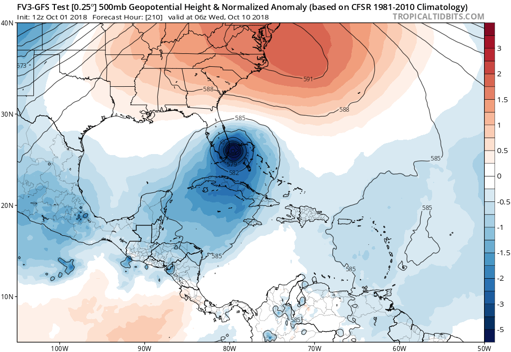
Whoa 12Z FV3 GFS hits SE Florida from the east 
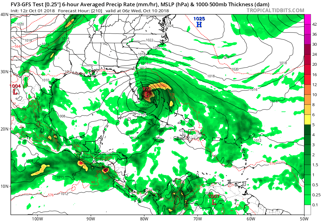
“Ridge over troubled waters:”
“Ridge over troubled waters:”
2 likes
Who is online
Users browsing this forum: TeamPlayersBlue and 69 guests