My best guess is no model at this point is right or wrong at this point. I lean towards the GEFS and 0Z EPS for highest probability. I think, looking at 6Z Euro heights, how the Euro-AI gets as far W as it does. Lower probability solution this late in the season, but not a zero probability solution.
20 years ago, Canadian was the 'crazy uncle', but improvements are made from time to time for all the models. I've seen 500 mb verification scores on another forum where the Canadian is close to or even exceeds the GFS. But the NAVGEM is still the NAVGEM.
Low pressure developing over the western Caribbean Sea (Is Invest 97L)
Moderator: S2k Moderators
Forum rules

The posts in this forum are NOT official forecasts and should not be used as such. They are just the opinion of the poster and may or may not be backed by sound meteorological data. They are NOT endorsed by any professional institution or STORM2K. For official information, please refer to products from the National Hurricane Center and National Weather Service.
-
HurricaneBrain

- S2K Supporter

- Posts: 520
- Joined: Thu Jun 30, 2011 2:07 pm
Re: Area of low pressure to develop over the western Caribbean Sea
EURO on board with it AI counterpart, with a SETX landfall @ 240 hours.
1 likes
-
toad strangler

- S2K Supporter
- Posts: 4546
- Joined: Sun Jul 28, 2013 3:09 pm
- Location: Earth
- Contact:
Re: Area of low pressure to develop over the western Caribbean Sea
12z EPS way E of Op. Decent spread from E LA to Tampa
0 likes
My Weather Station
https://www.wunderground.com/dashboard/pws/KFLPORTS603
https://www.wunderground.com/dashboard/pws/KFLPORTS603
-
Stratton23
- Category 5

- Posts: 3573
- Joined: Fri Jul 21, 2023 10:59 pm
- Location: Katy, Tx
Re: Area of low pressure to develop over the western Caribbean Sea
12z EPS is spread all the way from brownsville to florida lol, with more members going into the BOC
0 likes
-
SFLcane

- S2K Supporter
- Posts: 10281
- Age: 48
- Joined: Sat Jun 05, 2010 1:44 pm
- Location: Lake Worth Florida
Re: Area of low pressure to develop over the western Caribbean Sea
Another vantage point from the GEFS just about all members onm the 12z run show a turn NE into Florida.
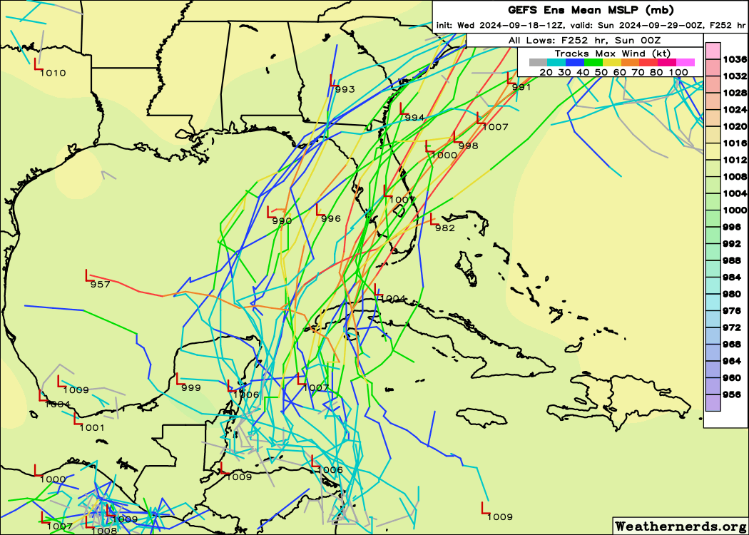
View of the GEFS control...
View of the GEFS control...
1 likes
-
wxman57

- Moderator-Pro Met

- Posts: 23175
- Age: 68
- Joined: Sat Jun 21, 2003 8:06 pm
- Location: Houston, TX (southwest)
Re: Area of low pressure to develop over the western Caribbean Sea
HurricaneBrain wrote:EURO on board with it AI counterpart, with a SETX landfall @ 240 hours.
But as a west Gulf low with a cold front extending south. Seems unlikely. ICON has a giant tropical storm in the south-central Gulf next Wednesday evening, with the upper-level flow suggesting a track toward northern Florida. That's more likely than the GFS solution. I don't know about ICON's giant wind field, though.
3 likes
-
jasons2k

- Storm2k Executive

- Posts: 8290
- Age: 52
- Joined: Wed Jul 06, 2005 12:32 pm
- Location: The Woodlands, TX
Re: Area of low pressure to develop over the western Caribbean Sea
DunedinDave wrote:I always look at the Hurricane Phoenix track as the most likely one to play out for a major storm to hit the TB area. If they’re gonna get it, it’s gonna come from that angle. Seems like some of the GFS ensembles want to copy that track here. Hope that doesn’t happen but it could form in that area with some of the ingredients for that right turn in place.
I remember the original simulation video they aired of that back in the 90’s. Classic.
I’m keeping a close watch on this one for relatives and property in Dunedin.
4 likes
-
jlauderdal
- S2K Supporter
- Posts: 7240
- Joined: Wed May 19, 2004 5:46 am
- Location: NE Fort Lauderdale
- Contact:
Re: Area of low pressure to develop over the western Caribbean Sea
SFLcane wrote:Another vantage point from the GEFS just about all members onm the 12z run show a turn NE into Florida.
https://i.postimg.cc/pTqcTnPm/ggg.png
View of the GEFS control...
https://i.postimg.cc/dt7Ns1p0/bbbb.png
The ensembles are not giving up on the east and thats the best modeling we have going right now...OP's getting the Texans excited, but that far west seems a bridge too far in this setup. Also, the gyre develops when it develops and its often times slower than the models and the internet would like so we need to see some real weather and then we can pair that up with what is happening upstream and in this case it would be the trough and where it digs.
Interesting to see the GFS OP come back so far with the central pressure, it was down around 944 a few cycles ago.
1 likes
Re: Area of low pressure to develop over the western Caribbean Sea
SFLcane wrote:Another vantage point from the GEFS just about all members onm the 12z run show a turn NE into Florida.
https://i.postimg.cc/pTqcTnPm/ggg.png
View of the GEFS control...
https://i.postimg.cc/dt7Ns1p0/bbbb.png
Seems to make the most sense...unfortunately...based on some of the local gulf coast forecast discussions I have read...mainly from New Orleans to the southern tip of Florida....if anything comes of this....its my understanding that the system will be steered north and east?....from the northwest carribean?...
0 likes
-
jlauderdal
- S2K Supporter
- Posts: 7240
- Joined: Wed May 19, 2004 5:46 am
- Location: NE Fort Lauderdale
- Contact:
Re: Area of low pressure to develop over the western Caribbean Sea
underthwx wrote:SFLcane wrote:Another vantage point from the GEFS just about all members onm the 12z run show a turn NE into Florida.
https://i.postimg.cc/pTqcTnPm/ggg.png
View of the GEFS control...
https://i.postimg.cc/dt7Ns1p0/bbbb.png
Seems to make the most sense...unfortunately...based on some of the local gulf coast forecast discussions I have read...mainly from New Orleans to the southern tip of Florida....if anything comes of this....its my understanding that the system will be steered north and east?....from the northwest carribean?...
Is coming north and east at some point, the question where that takes place and right now there is minimal agreement although, follow the ensembles for now and how they behave, OP's are eye candy and for entertainment purposes only. Dont get sucked into scary twitter posts!
1 likes
-
AtlanticWind

- S2K Supporter
- Posts: 1898
- Age: 67
- Joined: Sun Aug 08, 2004 9:57 pm
- Location: Plantation,Fla
Re: Area of low pressure to develop over the western Caribbean Sea
From Miami NWS discussion
The National Hurricane Center continues to monitor an area of low
pressure in the western Caribbean Sea with a 20% chance of
tropical development over the next seven days. Readers are
reminded that a lot can change in the 7-10 day time-frame,
especially with the genesis and evolution of tropical systems.
While the general pattern for tropical development appears to be
favorable, it remains far too early to identify a potential track.
In simplest terms, while deterministic model solutions will vary
from run to run, it is very important to take them with several
grains of salt. Ensemble model plots (EPS and GEFS) may provide a
slightly clearer picture of what may unfold, however it is still
quite early. Regardless of what transpires, this is an important
reminder that we are in the midst of the peak of hurricane season.
Although the climatological peak of the Atlantic hurricane season
is on September 10th, the stretch of late September into the
first half of October is the climatological peak for hurricane
landfalls in South Florida. Remain weather aware, check hurricane
supplies, and most importantly, be sure to receive information
from reliable sources such as the National Hurricane Center, NWS
Miami, and local and national broadcast media sources.
&&
3 likes

Re: Area of low pressure to develop over the western Caribbean Sea
The motion out of the NW Caribbean will depend a lot of it's strength. A weaker low will more closely follow the broad counterclockwise movement of the Gyre. This could lead the low/storm across the Yucatan, where it would begin to turn North and East later in its journey. The ICON is a good visualization of this.underthwx wrote:SFLcane wrote:Another vantage point from the GEFS just about all members onm the 12z run show a turn NE into Florida.
https://i.postimg.cc/pTqcTnPm/ggg.png
View of the GEFS control...
https://i.postimg.cc/dt7Ns1p0/bbbb.png
Seems to make the most sense...unfortunately...based on some of the local gulf coast forecast discussions I have read...mainly from New Orleans to the southern tip of Florida....if anything comes of this....its my understanding that the system will be steered north and east?....from the northwest carribean?...
Another reasonable option involves the low strengthening a bit faster. In this outcome the storm is stronger and less controlled by the pull from the Gyre. This outcome leads to very little western component, and a quicker northern movement. This could for example lead to a track across Southern Florida.
As of now I personally put more stock into the former option as the GFS has been overestimating how fast things come together this season. Either option is still on the table though, as well as some other more fringe outcomes.
3 likes
-
jlauderdal
- S2K Supporter
- Posts: 7240
- Joined: Wed May 19, 2004 5:46 am
- Location: NE Fort Lauderdale
- Contact:
Re: Area of low pressure to develop over the western Caribbean Sea
AtlanticWind wrote:From Miami NWS discussion
The National Hurricane Center continues to monitor an area of low
pressure in the western Caribbean Sea with a 20% chance of
tropical development over the next seven days. Readers are
reminded that a lot can change in the 7-10 day time-frame,
especially with the genesis and evolution of tropical systems.
While the general pattern for tropical development appears to be
favorable, it remains far too early to identify a potential track.
In simplest terms, while deterministic model solutions will vary
from run to run, it is very important to take them with several
grains of salt. Ensemble model plots (EPS and GEFS) may provide a
slightly clearer picture of what may unfold, however it is still
quite early. Regardless of what transpires, this is an important
reminder that we are in the midst of the peak of hurricane season.
Although the climatological peak of the Atlantic hurricane season
is on September 10th, the stretch of late September into the
first half of October is the climatological peak for hurricane
landfalls in South Florida. Remain weather aware, check hurricane
supplies, and most importantly, be sure to receive information
from reliable sources such as the National Hurricane Center, NWS
Miami, and local and national broadcast media sources.
&&
If anyone was not sure on the ensembles, you can trust the MIami NWS and they are right down the hall from the NHC so if they are confused they can just walk over and ask.
5 likes
-
StPeteMike

- Category 2

- Posts: 657
- Joined: Thu Jun 07, 2018 11:26 pm
Re: Area of low pressure to develop over the western Caribbean Sea
Decided to check out the Hurricane Michael Model thread, something always I like to do when storms form in similar areas. I was going to do Idalia, but the climatology is similar to Michael who came together about 2 weeks later than this is supposed to start getting together.
The similarities are definitely there and at the beginning, the discussion was anywhere between Houston to Sarasota at the beginning. Trough was also forecasted and depended on the strength and speed. Obviously, not all storms are the same even with similarities at the beginning, but it can give us some insight on what to expect.
The similarities are definitely there and at the beginning, the discussion was anywhere between Houston to Sarasota at the beginning. Trough was also forecasted and depended on the strength and speed. Obviously, not all storms are the same even with similarities at the beginning, but it can give us some insight on what to expect.
1 likes
The above post is not official and should not be used as such. It is the opinion of the poster and may or may not be backed by sound meteorological data. It is not endorsed by any professional institution or storm2k.org. For official information, please refer to the NHC and NWS products.

Re: Area of low pressure to develop over the western Caribbean Sea
StPeteMike wrote:Decided to check out the Hurricane Michael Model thread, something always I like to do when storms form in similar areas. I was going to do Idalia, but the climatology is similar to Michael who came together about 2 weeks later than this is supposed to start getting together.
The similarities are definitely there and at the beginning, the discussion was anywhere between Houston to Sarasota at the beginning. Trough was also forecasted and depended on the strength and speed. Obviously, not all storms are the same even with similarities at the beginning, but it can give us some insight on what to expect.
Indeed. What you can eapecially learn from those threads is not to pay much attention to intensity guidance at this point. Euro and GFS were all over the place with the Euro only showing a weak TS at +140 hrs and GFS flipping between anything from a TS to a C3 even at only +100 hrs. Intensity estimates become much better once we have something to track, but at this point general favorability and when/whether a TC forms are more important to focus on.
3 likes
-
ConvergenceZone
.gif)
- Category 5
- Posts: 5241
- Joined: Fri Jul 29, 2005 1:40 am
- Location: Northern California
Re: Area of low pressure to develop over the western Caribbean Sea
I wonder why they have the long range chance of development at only 20%? That just seems crazy! It makes me think that they don't have much confidence in this developing long-term.
0 likes

Re: Area of low pressure to develop over the western Caribbean Sea
ConvergenceZone wrote:I wonder why they have the long range chance of development at only 20%? That just seems crazy! It makes me think that they don't have much confidence in this developing long-term.
They always start out at 20% and the chances often increase as it gets closer. The TWO's are seven days now I believe, and not five.
2 likes
The above post is not official and should not be used as such. It is the opinion of the poster and may or may not be backed by sound meteorological data. It is not endorsed by any professional institution or storm2k.org. For official information, please refer to the NHC and NWS products.
-
StPeteMike
- Category 2
- Posts: 657
- Joined: Thu Jun 07, 2018 11:26 pm
Re: Area of low pressure to develop over the western Caribbean Sea
kevin wrote:StPeteMike wrote:Decided to check out the Hurricane Michael Model thread, something always I like to do when storms form in similar areas. I was going to do Idalia, but the climatology is similar to Michael who came together about 2 weeks later than this is supposed to start getting together.
The similarities are definitely there and at the beginning, the discussion was anywhere between Houston to Sarasota at the beginning. Trough was also forecasted and depended on the strength and speed. Obviously, not all storms are the same even with similarities at the beginning, but it can give us some insight on what to expect.
Indeed. What you can eapecially learn from those threads is not to pay much attention to intensity guidance at this point. Euro and GFS were all over the place with the Euro only showing a weak TS at +140 hrs and GFS flipping between anything from a TS to a C3 even at only +100 hrs. Intensity estimates become much better once we have something to track, but at this point general favorability and when/whether a TC forms are more important to focus on.
100%! Some of the models also had shear persistent over the northern Gulf to prevent Michael from quickly strengthening, those models were about 5 days out. We saw how well that shear was persistent…
0 likes
The above post is not official and should not be used as such. It is the opinion of the poster and may or may not be backed by sound meteorological data. It is not endorsed by any professional institution or storm2k.org. For official information, please refer to the NHC and NWS products.
-
StPeteMike
- Category 2
- Posts: 657
- Joined: Thu Jun 07, 2018 11:26 pm
Re: Area of low pressure to develop over the western Caribbean Sea
ConvergenceZone wrote:I wonder why they have the long range chance of development at only 20%? That just seems crazy! It makes me think that they don't have much confidence in this developing long-term.
If the models keep showing development by afternoon tomorrow, the percentage should be bumped to at least 40%. Friday, we should see 60%, and then by Saturday, close to 80-90% with us entering the 10-20% of development within 48 hours. If the models continue to show development and the environment is there for it.
2 likes
The above post is not official and should not be used as such. It is the opinion of the poster and may or may not be backed by sound meteorological data. It is not endorsed by any professional institution or storm2k.org. For official information, please refer to the NHC and NWS products.
-
Stormlover70
- Tropical Storm

- Posts: 194
- Age: 56
- Joined: Fri Jun 21, 2024 5:31 am
- Location: New port richey
Re: Area of low pressure to develop over the western Caribbean Sea
five miles north. I am watching closely.jasons2k wrote:DunedinDave wrote:I always look at the Hurricane Phoenix track as the most likely one to play out for a major storm to hit the TB area. If they’re gonna get it, it’s gonna come from that angle. Seems like some of the GFS ensembles want to copy that track here. Hope that doesn’t happen but it could form in that area with some of the ingredients for that right turn in place.
I remember the original simulation video they aired of that back in the 90’s. Classic.
I’m keeping a close watch on this one for relatives and property in Dunedin.
0 likes
Who is online
Users browsing this forum: No registered users and 231 guests