Tropical Wave East of the Leeward Islands (Is Invest 90L)
Moderator: S2k Moderators
Forum rules

The posts in this forum are NOT official forecasts and should not be used as such. They are just the opinion of the poster and may or may not be backed by sound meteorological data. They are NOT endorsed by any professional institution or STORM2K. For official information, please refer to products from the National Hurricane Center and National Weather Service.
-
Hurricaneman

- Category 5

- Posts: 7404
- Age: 45
- Joined: Tue Aug 31, 2004 3:24 pm
- Location: central florida
Re: Tropical Wave Near the Cabo Verde Islands (0/40)
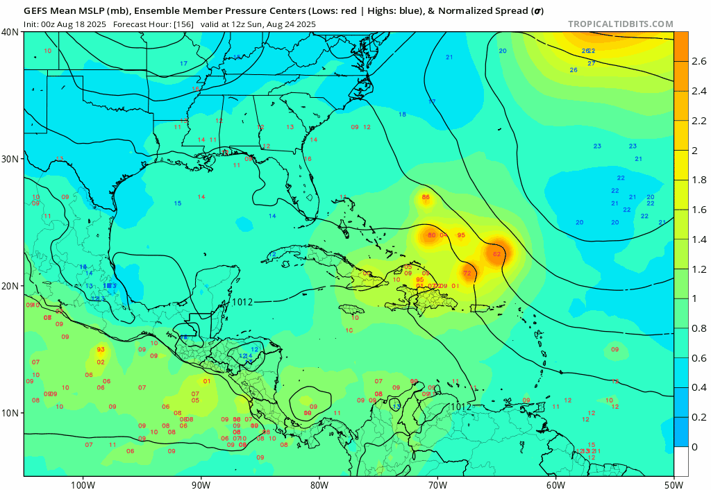
0zGFS seems to be close to a disaster, if this is 20mi north while near PR and Hispaniola and 100 mile east while going up the eastern seaboard it could be a major up the eastern seaboard from Florida to New England but since this is beyond day 9 it may not happen like this but solutions like these showing up means this needs to be watched closely
0 likes
-
Hurricaneman
- Category 5
- Posts: 7404
- Age: 45
- Joined: Tue Aug 31, 2004 3:24 pm
- Location: central florida
Re: Tropical Wave Near the Cabo Verde Islands (0/40)
LAF92 wrote:skillz305 wrote:Stratton23 wrote:00z GFS trending west, back into the gulf again, looks like landfall around the florida panhandle, trending towards a weaker east coast trough and stronger ridging building in
Sorry to correct, but that’s thru the keys and up the west coast into Ocala and out by Jacksonville, not the panhandle.
Point is that the ridge is building back in on this run thus moving the storm into the Gulf. It’s going to come down to timing and placement if the storm is able to stay south of landmasses through the Caribbean
Or even north of the Caribbean as that could put the eastern seaboard on alert
0 likes
Re: Tropical Wave Near the Cabo Verde Islands (0/40)
What is a bit concerning is that in the most recent runs on the GFS it’s been narrowing to an area from Louisiana to the Florida East Coast and not doing its wild shifts from Texas to Maine between each run in long range like it usually does
Also GFS is known for its early recurvatures and so far it has not done this on any runs even when north of the islands
Now that I say this watch the next run be either OTS, no formation or Yucatán landfall
Also GFS is known for its early recurvatures and so far it has not done this on any runs even when north of the islands
Now that I say this watch the next run be either OTS, no formation or Yucatán landfall
3 likes
-
Stratton23
- Category 5
- Posts: 3574
- Joined: Fri Jul 21, 2023 10:59 pm
- Location: Katy, Tx
Re: Tropical Wave Near the Cabo Verde Islands (0/40)
This is a very sensitive upper air pattern, any changes in the east coast troughs position, strength, does it cut off? Does the sub tropical ridge build back in and prevent an escape route away from the US? I definitely think their is a lot more volatility with this pattern compared to the one with erin, which it became pretty obviously clear that Erin didnt have really a chance to threaten the US directly because of its latitude that it started out with near the cabo verde islands , this wave is significantly further south, around 10 N latitude with most of the convection south of that, I have a gut feeling if this forms, its going to impact the US somewhere
1 likes
Re: Tropical Wave Near the Cabo Verde Islands (0/40)
The NHC 7 Day chances of it developing have increased to 50% now.
0 likes
-
cycloneye

- Admin

- Posts: 149702
- Age: 69
- Joined: Thu Oct 10, 2002 10:54 am
- Location: San Juan, Puerto Rico
Re: Tropical Wave Near the Cabo Verde Islands (0/50)
Tropical Weather Outlook
NWS National Hurricane Center Miami FL
200 AM EDT Mon Aug 18 2025
Tropical Atlantic:
A large area of disorganized showers and thunderstorms over the
eastern tropical Atlantic is associated with a tropical wave.
Environmental conditions appear conducive for gradual development
of this system, and a tropical depression could form during the
latter part of the week while moving westward to west-northwestward
at about 20 mph across the central tropical Atlantic, possibly
approaching the vicinity of the Leeward Islands on Friday.
* Formation chance through 48 hours...low...near 0 percent.
* Formation chance through 7 days...medium...50 percent.
$$
Forecaster Berg

0 likes
Visit the Caribbean-Central America Weather Thread where you can find at first post web cams,radars
and observations from Caribbean basin members Click Here
and observations from Caribbean basin members Click Here
-
Stratton23
- Category 5
- Posts: 3574
- Joined: Fri Jul 21, 2023 10:59 pm
- Location: Katy, Tx
Re: Tropical Wave Near the Cabo Verde Islands (0/50)
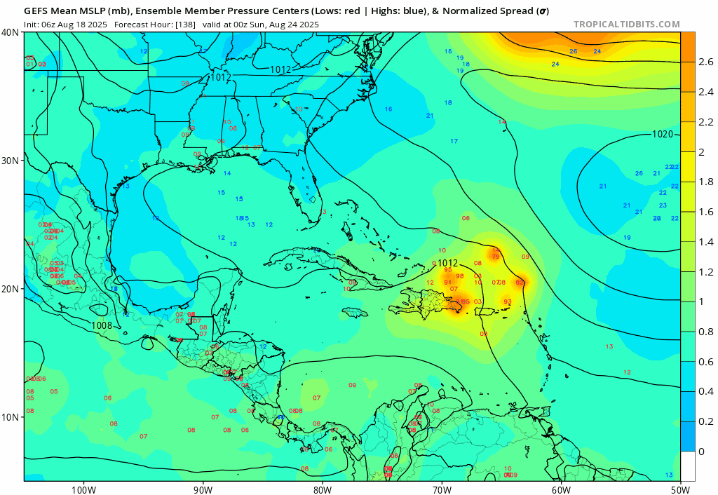
00z EPS really made a significant shift west compared to the operational run which is out to sea, EPS is a bigger threat to the US on this run with more members in the gulf and also another camp impacting the SE US
2 likes

Re: Tropical Wave SW of the Cabo Verde Islands (0/50)
Stratton23 wrote:00z EPS really made a significant shift west compared to the operational run which is out to sea, EPS is a bigger threat to the US on this run with more members in the gulf and also another camp impacting the SE US

Quite the west shift indeed:
Sent from my iPad using Tapatalk
1 likes
-
Cachondo23
- Tropical Storm

- Posts: 131
- Joined: Wed May 25, 2022 5:56 am
Re: Tropical Wave SW of the Cabo Verde Islands (0/50)
Wonder why models have this system weak at times. Thought the general atmosphere was favorable.
0 likes
-
jlauderdal
- S2K Supporter

- Posts: 7240
- Joined: Wed May 19, 2004 5:46 am
- Location: NE Fort Lauderdale
- Contact:
Re: Tropical Wave SW of the Cabo Verde Islands (0/50)
N2FSU wrote:Stratton23 wrote:00z EPS really made a significant shift west compared to the operational run which is out to sea, EPS is a bigger threat to the US on this run with more members in the gulf and also another camp impacting the SE US
https://uploads.tapatalk-cdn.com/20250818/4af2c11385f31a8340ab3563a0966baa.jpg
Quite the west shift indeed:
Sent from my iPad using Tapatalk
Interesting setup with the shredder in play, all kinds of outcomes are possible with anything around the Mona passage
0 likes
-
TomballEd
- Category 5
- Posts: 1318
- Age: 62
- Joined: Wed Aug 16, 2023 4:52 pm
- Location: Spring/Klein area, not Tomball
Re: Tropical Wave SW of the Cabo Verde Islands (0/50)
6Z GFS recurves a weak system. Passes through Hispaniola, but we weak even before that happened.

0 likes


Re: Tropical Wave SW of the Cabo Verde Islands (0/50)
Yeah, it follows the path from Erin. The solution seems plausible given Erin's slow movement.TomballEd wrote:6Z GFS recurves a weak system. Passes through Hispaniola, but we weak even before that happened.
1 likes

-
cycloneye
- Admin
- Posts: 149702
- Age: 69
- Joined: Thu Oct 10, 2002 10:54 am
- Location: San Juan, Puerto Rico
Re: Tropical Wave in the Eastern Atlantic (0/50)
Tropical Weather Outlook
NWS National Hurricane Center Miami FL
800 AM EDT Mon Aug 18 2025
For the North Atlantic...Caribbean Sea and the Gulf of America:
Active Systems:
The National Hurricane Center is issuing advisories on Hurricane
Erin, located a little over 100 miles north-northeast of Grand Turk
Island.
Tropical Atlantic:
A tropical wave located over the eastern tropical Atlantic is
producing disorganized showers and thunderstorms. Environmental
conditions appear conducive for gradual development of this system,
and a tropical depression could form during the latter part of the
week. This system should move westward to west-northwestward at
about 20 mph across the central tropical Atlantic and approach the
vicinity of the Leeward Islands toward the end of the week.
* Formation chance through 48 hours...low...near 0 percent.
* Formation chance through 7 days...medium...50 percent.
$$
Forecaster Roberts

0 likes
Visit the Caribbean-Central America Weather Thread where you can find at first post web cams,radars
and observations from Caribbean basin members Click Here
and observations from Caribbean basin members Click Here
Re: Tropical Wave in the Eastern Atlantic (0/50)
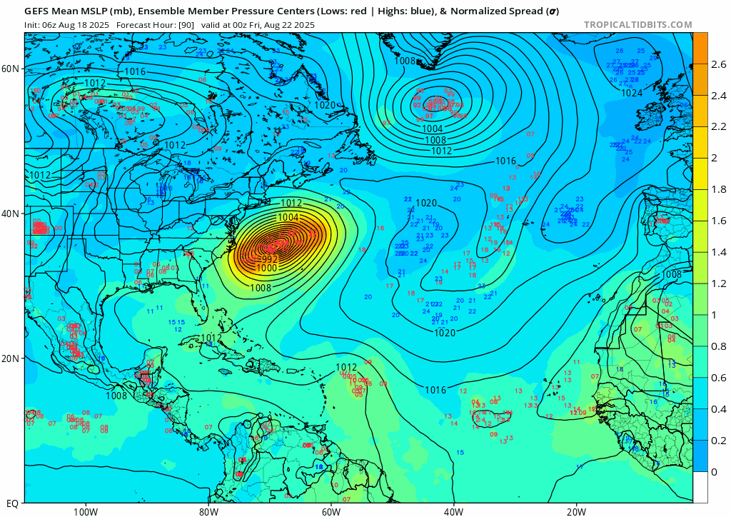
6z GFS ensembles all landfall somewhere, (Gulf to Canada)
1 likes
-
jlauderdal
- S2K Supporter
- Posts: 7240
- Joined: Wed May 19, 2004 5:46 am
- Location: NE Fort Lauderdale
- Contact:
Re: Tropical Wave in the Eastern Atlantic (0/50)
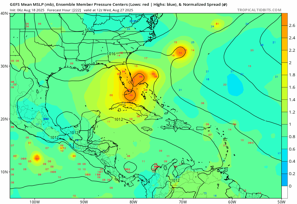
222 hours out, we will take it then recurve on the next few cycles. What we dont want to see is a repeat of 1935.
1 likes

Re: Tropical Wave in the Eastern Atlantic (0/50)
I’ll take a tropical storm out of this since I can count on one hand how many times it rained this year in SE Florida.
5 likes
-
hurricane2025
- Category 1

- Posts: 254
- Joined: Thu Apr 08, 2021 10:36 am
Re: Tropical Wave in the Eastern Atlantic (0/50)
Still a lot of things in play let’s see where it develops and also when it hits land if it reforms a center, will the trough be strong, how quick does erin kick out..
0 likes
Who is online
Users browsing this forum: pepecool20 and 172 guests