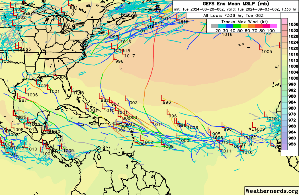
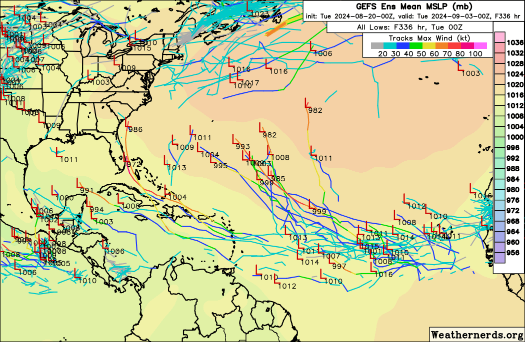
2024 Global Model Runs Discussion (Out thru day 16)

This is the general tropical discussion area. Anyone can take their shot at predicting a storms path.

Moderator: S2k Moderators

Forum rules

The posts in this forum are NOT official forecasts and should not be used as such. They are just the opinion of the poster and may or may not be backed by sound meteorological data. They are NOT endorsed by any professional institution or STORM2K. For official information, please refer to products from the National Hurricane Center and National Weather Service.

Help Support Storm2K
Message
Author
TomballEd
Category 2
Category 2
Posts: 599
Age: 61
Joined: Wed Aug 16, 2023 4:52 pm
Location: Spring/Klein area, not Tomball

Re: 2024 Global Model Runs Discussion (Out thru day 16)

#1081 Postby TomballEd » Tue Aug 20, 2024 6:36 am

Hammy wrote:
Teban54 wrote:0z GEFS... I don't think I need to say much before comments about SFL begin :lol:
https://i.postimg.cc/prc6ChBW/gefs-2024-08-20-00-Z-336-50-258-0-350-MSLP-Surface-tracks-lows.png


Looks like at least three distinct clusters on there, and fairly visible on Tropical Tidbits map https://i.imgur.com/8PBlrfR.png


Time for work. That is a signal. 3 clusters. Not saying it happens, but the member near Miami, that is always interesting. The signal for activity in early September is picking up.
0 likes   

User avatar
aspen
Category 5
Category 5
Posts: 8812
Joined: Sat Oct 12, 2019 7:10 pm
Location: Connecticut, USA

Re: 2024 Global Model Runs Discussion (Out thru day 16)

#1082 Postby aspen » Tue Aug 20, 2024 6:42 am

Welp, look at that. We hit August 20th and suddenly the models light up again.
2 likes   
Irene '11 Sandy '12 Hermine '16 5/15/2018 Derecho Fay '20 Isaias '20 Elsa '21 Henri '21 Ida '21

I am only a meteorology enthusiast who knows a decent amount about tropical cyclones. Look to the professional mets, the NHC, or your local weather office for the best information.

User avatar
Hypercane_Kyle
Category 5
Category 5
Posts: 3344
Joined: Sat Mar 07, 2015 7:58 pm
Location: Cape Canaveral, FL

Re: 2024 Global Model Runs Discussion (Out thru day 16)

#1083 Postby Hypercane_Kyle » Tue Aug 20, 2024 6:42 am

Finally seeing signs of the long-awaited "switch" on the models in the long range.
0 likes   
My posts are my own personal opinion, defer to the National Hurricane Center (NHC) and other NOAA products for decision making during hurricane season.

User avatar
toad strangler
S2K Supporter
S2K Supporter
Posts: 4543
Joined: Sun Jul 28, 2013 3:09 pm
Location: Earth
Contact:

Re: 2024 Global Model Runs Discussion (Out thru day 16)

#1084 Postby toad strangler » Tue Aug 20, 2024 7:34 am

The 6z GFS ensembles are bubbling with activity in the W basin long range. (1st week of September)
0 likes   

User avatar
SFLcane
S2K Supporter
S2K Supporter
Posts: 10162
Age: 47
Joined: Sat Jun 05, 2010 1:44 pm
Location: Lake Worth Florida

Re: 2024 Global Model Runs Discussion (Out thru day 16)

#1085 Postby SFLcane » Tue Aug 20, 2024 7:54 am

toad strangler wrote:The 6z GFS ensembles are bubbling with activity in the W basin long range. (1st week of September)


:double:

Image
2 likes   

LarryWx
S2K Supporter
S2K Supporter
Posts: 6248
Joined: Sun Sep 07, 2003 2:04 pm
Location: GA

Re: 2024 Global Model Runs Discussion (Out thru day 16)

#1086 Postby LarryWx » Tue Aug 20, 2024 7:56 am

Probably not worth that much but fwiw the last 4 Euro-AIFS suggest the area around Luis (PR) may have to watch for a nearby TC ~Sep 3. Again, fwiw.

Will be interesting to see what todays Euro weeklies show after yesterday’s sudden pretty sharp downturn (ACE fell to 28 from 40, which is about where it had been for 7 days) for 3 weeks ending mid Sep. So, it still had some activity but was BN. Was that just a blip?
0 likes   
Personal Forecast Disclaimer:
The posts in this forum are NOT official forecasts and should not be used as such. They are just the opinion of the poster and may or may not be backed by sound meteorological data. They are NOT endorsed by any professional institution or storm2k.org. For official information, please refer to the NHC and NWS products.

User avatar
Teban54
Category 5
Category 5
Posts: 3169
Joined: Sat May 19, 2018 1:19 pm

Re: 2024 Global Model Runs Discussion (Out thru day 16)

#1087 Postby Teban54 » Tue Aug 20, 2024 8:19 am

SFLcane wrote:
toad strangler wrote:The 6z GFS ensembles are bubbling with activity in the W basin long range. (1st week of September)


:double:

https://i.postimg.cc/GhZND8q9/IMG-9281.png

The ensembles are also much further south of the operational GFS, and much less of a clear-cut recurve.
0 likes   

User avatar
skyline385
Category 5
Category 5
Posts: 2728
Age: 34
Joined: Wed Aug 26, 2020 11:15 pm
Location: Houston TX

Re: 2024 Global Model Runs Discussion (Out thru day 16)

#1088 Postby skyline385 » Tue Aug 20, 2024 8:34 am

TomballEd wrote:
toad strangler wrote:
TomballEd wrote:
I said August has been dead since Ernesto. I didn't say this year was dead. I lost power 5 days in Beryl. I am saying after an active start, this year has slowed considerably. If you read my posts you'd see I am looking into September for an upturn and I still expect above average ACE and NS, just well below the April-June forecast of a near record active season. Please read in context.


You said literally "just noting how dead this year is."
And while we are at it, Ernesto is still alive :D so how can it be dead since Ernesto?

I'm not trying to nudge you. I'm just confused at some of your statements. I'm sure you understand it all. Maybe typing too fast? :ggreen:

Ernesto passed Bermuda, and is now causing high surf and riptides, but is moving away from Newfoundland and isn't really tropical anymore. I'm more addressing people that for at least 7 days plus now looking at 15 day ensembles, seeing one or two members with a storm, and calling it a signal. There is a signal now, but it isn't until the very end of August, most likely September. Posting a cluster of 1010 mb 20-30 knot ensemble members with a couple of strong members, not much of a signal. There is a signal, but beyond 10 days.


The GoM signal on the Euro is in 5 days.

The MDR wave developing in the models comes offshore in 2-3 days and it is too early to assume that it won't develop for another week after that. 6z GFS first develops it at 168hrs or 7 days from now which is also close to when the Euro 0z showed a tight vorticity signature.

These are all the first runs showing the switch flip. Models will uptrend a bit more in the next few days as more of the the changing conditions enter initialization. This happens every single year. Just look at 6z GFS vs 0z GFS as an example.
Last edited by skyline385 on Tue Aug 20, 2024 8:48 am, edited 1 time in total.
2 likes   

MEANINGLESS_NUMBERS
Category 1
Category 1
Posts: 325
Joined: Mon Nov 02, 2020 1:43 pm

Re: 2024 Global Model Runs Discussion (Out thru day 16)

#1089 Postby MEANINGLESS_NUMBERS » Tue Aug 20, 2024 8:44 am

GFS with another Bermuda hurricane. Cat 3 this time.

Ensembles with most of the action east of 70W but all have a couple members in GOM or SFL. Still, not bad for this time of year.
0 likes   
Emily '87, Felix '95, Gert '99, Fabian '03, Humberto '19, Paulette '20, Teddy '20, Fiona '22, Lee '23, Ernesto '24

User avatar
Teban54
Category 5
Category 5
Posts: 3169
Joined: Sat May 19, 2018 1:19 pm

Re: 2024 Global Model Runs Discussion (Out thru day 16)

#1090 Postby Teban54 » Tue Aug 20, 2024 10:30 am

12z ICON continues to spin up a brief TD/TS near 45W in 3 days. This time, there's also a low near 30W around the same time frame, which is a little bit more pronounced than earlier runs. It's still the only model that show either system developing this far east.

Fun fact... If both become short-lived named storms as well as the ECMWF GoM system, the possible MDR long-tracker that GFS, GEFS and some EPS members are showing would become the I storm. Of course, that's very unlikely and pure speculation at this point.

Image
0 likes   

LarryWx
S2K Supporter
S2K Supporter
Posts: 6248
Joined: Sun Sep 07, 2003 2:04 pm
Location: GA

Re: 2024 Global Model Runs Discussion (Out thru day 16)

#1091 Postby LarryWx » Tue Aug 20, 2024 1:10 pm

12Z GEFS: again looks rather active for first few days of Sept.
0 likes   
Personal Forecast Disclaimer:
The posts in this forum are NOT official forecasts and should not be used as such. They are just the opinion of the poster and may or may not be backed by sound meteorological data. They are NOT endorsed by any professional institution or storm2k.org. For official information, please refer to the NHC and NWS products.

TomballEd
Category 2
Category 2
Posts: 599
Age: 61
Joined: Wed Aug 16, 2023 4:52 pm
Location: Spring/Klein area, not Tomball

Re: 2024 Global Model Runs Discussion (Out thru day 16)

#1092 Postby TomballEd » Tue Aug 20, 2024 1:13 pm

SFLcane wrote:
toad strangler wrote:The 6z GFS ensembles are bubbling with activity in the W basin long range. (1st week of September)


:double:

https://i.postimg.cc/GhZND8q9/IMG-9281.png


It isn't until September, but there is a consensus for one or more MDR storms GEFS mean ridge would seem to put E GOMEX up the East Coast in play early September. The missing image is the STR extending almost all the way to Florida.

Image
0 likes   

User avatar
SFLcane
S2K Supporter
S2K Supporter
Posts: 10162
Age: 47
Joined: Sat Jun 05, 2010 1:44 pm
Location: Lake Worth Florida

Re: 2024 Global Model Runs Discussion (Out thru day 16)

#1093 Postby SFLcane » Tue Aug 20, 2024 1:26 pm

TomballEd wrote:
SFLcane wrote:
toad strangler wrote:The 6z GFS ensembles are bubbling with activity in the W basin long range. (1st week of September)


:double:

https://i.postimg.cc/GhZND8q9/IMG-9281.png


It isn't until September, but there is a consensus for one or more MDR storms GEFS mean ridge would seem to put E GOMEX up the East Coast in play early September. The missing image is the STR extending almost all the way to Florida.

https://www.tropicaltidbits.com/analysis/models/gfs-ens/2024082012/gfs-ens_z500aNorm_us_56.png


You can use this to post images and just add the img tags

https://postimages.org/
1 likes   

User avatar
ConvergenceZone
Category 5
Category 5
Posts: 5194
Joined: Fri Jul 29, 2005 1:40 am
Location: Northern California

Re: 2024 Global Model Runs Discussion (Out thru day 16)

#1094 Postby ConvergenceZone » Tue Aug 20, 2024 1:29 pm

The question is, will the Bermuda High continue to be weak as WxMan pointed out and allow the Atlantic storms that form to recurve? I guess we will know before too long.
0 likes   

User avatar
Teban54
Category 5
Category 5
Posts: 3169
Joined: Sat May 19, 2018 1:19 pm

Re: 2024 Global Model Runs Discussion (Out thru day 16)

#1095 Postby Teban54 » Tue Aug 20, 2024 1:52 pm

FWIW, 12z operational GFS drops all hurricanes from the past two runs, except for a TS trying to intensify offshore Tampa Bay that ran out of time. 12z GEFS still seems to show a similar number of strong members at 16 days, but the tracks seem further SW, and it also seems to have a slightly stronger preference for a later wave than recent runs (which results in delayed development). It also shows a few more strong hurricanes in the Caribbean proper.

Keep in mind, this is a period of time when models can flip-flop often, especially at the lead times we're discussing.
0 likes   

Stratton23
Category 5
Category 5
Posts: 2374
Joined: Fri Jul 21, 2023 10:59 pm
Location: Katy, Tx

Re: 2024 Global Model Runs Discussion (Out thru day 16)

#1096 Postby Stratton23 » Tue Aug 20, 2024 1:53 pm

it also depends on where it forms, a weaker bermuda high doesn’t necessarily mean a recurve is likely, especially if a wave waits to develop in the western part of the caribbean, just have to watch and see how this plays out, but its about to get busy
0 likes   

User avatar
crownweather
S2K Supporter
S2K Supporter
Posts: 591
Age: 50
Joined: Sat Aug 12, 2006 9:21 am
Location: Sturbridge, Massachusetts
Contact:

Re: 2024 Global Model Runs Discussion (Out thru day 16)

#1097 Postby crownweather » Tue Aug 20, 2024 1:54 pm

12Z EPS for Labor Day looks pretty active IMHO

Image
7 likes   
Rob Lightbown
Crown Weather Services
https://crownweather.com

IcyTundra
Category 5
Category 5
Posts: 1205
Joined: Mon Jun 07, 2021 9:32 pm
Location: Dickinson, Texas

Re: 2024 Global Model Runs Discussion (Out thru day 16)

#1098 Postby IcyTundra » Tue Aug 20, 2024 2:14 pm


It sure does the basin will be more favorable by then for sure.
0 likes   

Stratton23
Category 5
Category 5
Posts: 2374
Joined: Fri Jul 21, 2023 10:59 pm
Location: Katy, Tx

Re: 2024 Global Model Runs Discussion (Out thru day 16)

#1099 Postby Stratton23 » Tue Aug 20, 2024 4:28 pm

ICON and Euro both show some slight development of the mid level disturbance that crosses the gulf next week, as the energy pinches off from the trough and moves into the gulf, the ICON and Euro models do attempt to tighten up the vorticity signature just a bit, while most guidance really doesnt show development, it will be crossing over the hottest part of the gulf as it moves west towards texas, has 2-2.5 days over water, worth watching as upper lows over the gulf can be very tricky and sometimes develop even when models dont expect it
0 likes   

User avatar
Blown Away
S2K Supporter
S2K Supporter
Posts: 10140
Joined: Wed May 26, 2004 6:17 am

Re: 2024 Global Model Runs Discussion (Out thru day 16)

#1100 Postby Blown Away » Tue Aug 20, 2024 4:41 pm

It’s been a while since we had a true happy hour 18z GFS… I think we are due!! :D
1 likes   
Hurricane Eye Experience: David 79, Irene 99, Frances 04, Jeanne 04, Wilma 05... EYE COMING MY WAY IN 2024…
Hurricane Brush Experience: Andrew 92, Erin 95, Floyd 99, Matthew 16, Irma 17, Ian 22, Nicole 22…


Return to “Talkin' Tropics”

Who is online

Users browsing this forum: Google Adsense [Bot], MarioProtVI, MetroMike and 231 guests