2022 Indicators (SSTs/SAL/MSLP/Shear/Steering/Instability) and >Day 16 Models
Moderator: S2k Moderators
Forum rules

The posts in this forum are NOT official forecasts and should not be used as such. They are just the opinion of the poster and may or may not be backed by sound meteorological data. They are NOT endorsed by any professional institution or STORM2K. For official information, please refer to products from the National Hurricane Center and National Weather Service.
-
SFLcane

- S2K Supporter

- Posts: 10281
- Age: 48
- Joined: Sat Jun 05, 2010 1:44 pm
- Location: Lake Worth Florida
Re: 2022 Indicators (SSTs/SAL/MSLP/Shear/Steering/Instability) and >Day 16 Models
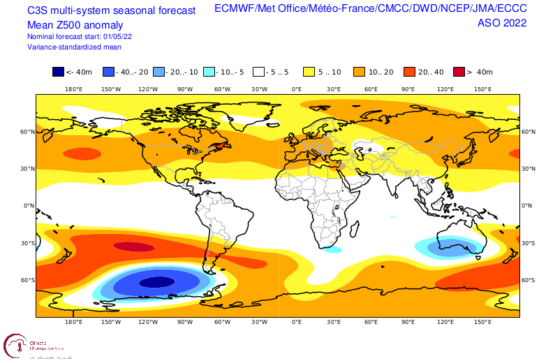
In terms of looking at those precipiation anomalies some models have Caribbean some SW ATL which could imply more ridging over the CONUS. 
0 likes
-
skyline385

- Category 5

- Posts: 2728
- Age: 35
- Joined: Wed Aug 26, 2020 11:15 pm
- Location: Houston TX
2022 Indicators (SSTs/SAL/MSLP/Shear/Steering/Instability) and >Day 16 Models
SFLcane wrote:In terms of looking at those precipiation anomalies some models have Caribbean some SW ATL which could imply more ridging over the CONUS.
Comparing to 2020 forecast, a lot of the precipitation is out to sea near the East coast
It is more active than 2021 but there is a pretty decent gap ACE-wise to fill better 2020 and 2021. It also lines up pretty well with the CSU 180-ish prediction.
0 likes
-
SFLcane
- S2K Supporter
- Posts: 10281
- Age: 48
- Joined: Sat Jun 05, 2010 1:44 pm
- Location: Lake Worth Florida
Re: 2022 Indicators (SSTs/SAL/MSLP/Shear/Steering/Instability) and >Day 16 Models
skyline385 wrote:SFLcane wrote:In terms of looking at those precipiation anomalies some models have Caribbean some SW ATL which could imply more ridging over the CONUS.
Comparing to 2020 forecast, a lot of the precipitation is out to sea near the East coast
It is more active than 2021 but there is a pretty decent gap ACE-wise to fill better 2020 and 2021.
Meh, its just a general thought tc's do track outside of those anomalies.
2 likes
-
skyline385
- Category 5
- Posts: 2728
- Age: 35
- Joined: Wed Aug 26, 2020 11:15 pm
- Location: Houston TX
2022 Indicators (SSTs/SAL/MSLP/Shear/Steering/Instability) and >Day 16 Models
SFLcane wrote:skyline385 wrote:SFLcane wrote:In terms of looking at those precipiation anomalies some models have Caribbean some SW ATL which could imply more ridging over the CONUS.
Comparing to 2020 forecast, a lot of the precipitation is out to sea near the East coast
It is more active than 2021 but there is a pretty decent gap ACE-wise to fill better 2020 and 2021.
Meh, its just a general thought tc's do track outside of those anomalies.
Yes, my comment was a comparison with the 2020 forecast nothing more. I wouldn't take any long range forecasts at face value.
2 likes
-
skyline385
- Category 5
- Posts: 2728
- Age: 35
- Joined: Wed Aug 26, 2020 11:15 pm
- Location: Houston TX
2022 Indicators (SSTs/SAL/MSLP/Shear/Steering/Instability) and >Day 16 Models
Looks like Andy also reached the same consensus as what i posted earlier.
https://twitter.com/andyhazelton/status/1536338688984088577
https://twitter.com/andyhazelton/status/1536338688984088577
0 likes
-
SFLcane
- S2K Supporter
- Posts: 10281
- Age: 48
- Joined: Sat Jun 05, 2010 1:44 pm
- Location: Lake Worth Florida
Re: 2022 Indicators (SSTs/SAL/MSLP/Shear/Steering/Instability) and >Day 16 Models
No way off knowing if everything stays in the Caribbean could be just north of the islands its impossible to know those fine details in my opinion. The fact its not showing quick recurves before the islands is quite worrisome.
1 likes
-
Category5Kaiju

- Category 5
- Posts: 4322
- Joined: Thu Dec 24, 2020 12:45 pm
- Location: Seattle and Phoenix
Re: 2022 Indicators (SSTs/SAL/MSLP/Shear/Steering/Instability) and >Day 16 Models
I have a feeling that if some of these forecasts pan out, then 2022 is going to fall into the group of seasons that are talked about and referenced to like lore in future seasons, much like the years 2004, 2005, and 2017 are.
7 likes
Unless explicitly stated, all info in my posts is based on my own opinions and observations. Tropical storms and hurricanes can be extremely dangerous. Refer to an accredited weather research agency or meteorologist if you need to make serious decisions regarding an approaching storm.
-
tolakram
- Admin

- Posts: 20174
- Age: 62
- Joined: Sun Aug 27, 2006 8:23 pm
- Location: Florence, KY (name is Mark)
Re: 2022 Indicators (SSTs/SAL/MSLP/Shear/Steering/Instability) and >Day 16 Models
Category5Kaiju wrote:I have a feeling that if some of these forecasts pan out, then 2022 is going to fall into the group of seasons that are talked about and referenced to like lore in future seasons, much like the years 2004, 2005, and 2017 are.
Extreme seasons in either direction are difficult if not impossible to predict. The early amateur hyping of this season is way way over the top in my opinion and will lead to even more season cancel and down casting if the season turns out to be 'just' above normal. I think we all need to respect the fact that one thing that makes hurricane seasons interesting is their unpredictability.
That might be a nice way of saying ... chill out.
8 likes
M a r k
- - - - -
Join us in chat: Storm2K Chatroom Invite. Android and IOS apps also available.
The posts in this forum are NOT official forecasts and should not be used as such. Posts are NOT endorsed by any professional institution or STORM2K.org. For official information and forecasts, please refer to NHC and NWS products.
-
toad strangler

- S2K Supporter
- Posts: 4546
- Joined: Sun Jul 28, 2013 3:09 pm
- Location: Earth
- Contact:
Re: 2022 Indicators (SSTs/SAL/MSLP/Shear/Steering/Instability) and >Day 16 Models
tolakram wrote:Category5Kaiju wrote:I have a feeling that if some of these forecasts pan out, then 2022 is going to fall into the group of seasons that are talked about and referenced to like lore in future seasons, much like the years 2004, 2005, and 2017 are.
Extreme seasons in either direction are difficult if not impossible to predict. The early amateur hyping of this season is way way over the top in my opinion and will lead to even more season cancel and down casting if the season turns out to be 'just' above normal. I think we all need to respect the fact that one thing that makes hurricane seasons interesting is their unpredictability.
That might be a nice way of saying ... chill out.
I like to say that tropical seasons are just like snowflakes. They are ALL different. I don't care if every indicator on the stick are exactly the same as a previous year the new season will still be different than those analogs and probably significantly so.
4 likes
My Weather Station
https://www.wunderground.com/dashboard/pws/KFLPORTS603
https://www.wunderground.com/dashboard/pws/KFLPORTS603
-
captainbarbossa19

- Professional-Met

- Posts: 1094
- Age: 27
- Joined: Wed Aug 21, 2019 11:09 pm
- Location: Beaumont, TX
Re: 2022 Indicators (SSTs/SAL/MSLP/Shear/Steering/Instability) and >Day 16 Models
toad strangler wrote:tolakram wrote:Category5Kaiju wrote:I have a feeling that if some of these forecasts pan out, then 2022 is going to fall into the group of seasons that are talked about and referenced to like lore in future seasons, much like the years 2004, 2005, and 2017 are.
Extreme seasons in either direction are difficult if not impossible to predict. The early amateur hyping of this season is way way over the top in my opinion and will lead to even more season cancel and down casting if the season turns out to be 'just' above normal. I think we all need to respect the fact that one thing that makes hurricane seasons interesting is their unpredictability.
That might be a nice way of saying ... chill out.
I like to say that tropical seasons are just like snowflakes. They are ALL different. I don't care if every indicator on the stick are exactly the same as a previous year the new season will still be different than those analogs and probably significantly so.
I agree about the snowflake analogy. However, I do think that there are general trends with active seasons and inactive ones and that these trends can be determined by analyzing various teleconnections. I think that the game chess is a good way of representing this idea. The first move is important and starts to establish a pattern on the board. Expert chess players can see pathways to checkmate starting with the the first move, but it becomes more clear as the game continues. However, sometimes the game progresses differently than they anticipate, and players must adjust their strategy. Similarly, meteorologists/climatologists are at one end of the board, while nature is at the other. Whether or not man is right in predicting the pathway to victory (in weather, this would be the correct seasonal outlook) depends on how nature responds as time progresses and sometimes, weather experts must adjust their strategy.
Edit: Also, weather always plays white. It always makes the first move and man must respond.
5 likes


Re: 2022 Indicators (SSTs/SAL/MSLP/Shear/Steering/Instability) and >Day 16 Models
What are third year cold ENSO specifically like for Atlantic hurricane seasons? There are 3 definitive since 1950, but rather small sample size. All three nest within a -PDO.
1956
1975
2000
Reiterate very small sample size, doesn't come around often. You do have some cold neutrals but I won't include those in this post. The Ninas after Ninos tend to be the biggest hitters more consistently like 1998, 2005, 2017, 2020 etc.
1956
1975
2000
Reiterate very small sample size, doesn't come around often. You do have some cold neutrals but I won't include those in this post. The Ninas after Ninos tend to be the biggest hitters more consistently like 1998, 2005, 2017, 2020 etc.
4 likes
The above post and any post by Ntxw is NOT an official forecast and should not be used as such. It is just the opinion of the poster and may or may not be backed by sound meteorological data. It is NOT endorsed by any professional institution including Storm2k. For official information, please refer to NWS products.
Help support Storm2K!
-
Kingarabian

- S2K Supporter
- Posts: 16338
- Joined: Sat Aug 08, 2009 3:06 am
- Location: Honolulu, Hawaii
Re: 2022 Indicators (SSTs/SAL/MSLP/Shear/Steering/Instability) and >Day 16 Models
Yeah I wonder if 2022 will break that trend 
2 likes
RIP Kobe Bryant
-
Category5Kaiju
- Category 5
- Posts: 4322
- Joined: Thu Dec 24, 2020 12:45 pm
- Location: Seattle and Phoenix
Re: 2022 Indicators (SSTs/SAL/MSLP/Shear/Steering/Instability) and >Day 16 Models
Ntxw wrote:What are third year cold ENSO specifically like for Atlantic hurricane seasons? There are 3 definitive since 1950, but rather small sample size. All three nest within a -PDO.
1956
1975
2000
Reiterate very small sample size, doesn't come around often. You do have some cold neutrals but I won't include those in this post. The Ninas after Ninos tend to be the biggest hitters more consistently like 1998, 2005, 2017, 2020 etc.
But then quite interestingly, if you look at second year La Nina’s such as 1933, 1999, and 2008, you can see why the Nina-after-Nino bit hit idea is not a 100% foolproof pattern, as there are definitely some second year La Ninas that have been very destructive. Also, iirc, wasn’t 2017 a second year La Nina?
1 likes
Unless explicitly stated, all info in my posts is based on my own opinions and observations. Tropical storms and hurricanes can be extremely dangerous. Refer to an accredited weather research agency or meteorologist if you need to make serious decisions regarding an approaching storm.
Re: 2022 Indicators (SSTs/SAL/MSLP/Shear/Steering/Instability) and >Day 16 Models
Category5Kaiju wrote:Ntxw wrote:What are third year cold ENSO specifically like for Atlantic hurricane seasons? There are 3 definitive since 1950, but rather small sample size. All three nest within a -PDO.
1956
1975
2000
Reiterate very small sample size, doesn't come around often. You do have some cold neutrals but I won't include those in this post. The Ninas after Ninos tend to be the biggest hitters more consistently like 1998, 2005, 2017, 2020 etc.
But then quite interestingly, if you look at second year La Nina’s such as 1933, 1999, and 2008, you can see why the Nina-after-Nino bit hit idea is not a 100% foolproof pattern, as there are definitely some second year La Ninas that have been very destructive. Also, iirc, wasn’t 2017 a second year La Nina?
You are correct 2017 is 2nd year! There are some pretty big 2nd year. It's not foolproof but your odds are greater with the 1st.
0 likes
The above post and any post by Ntxw is NOT an official forecast and should not be used as such. It is just the opinion of the poster and may or may not be backed by sound meteorological data. It is NOT endorsed by any professional institution including Storm2k. For official information, please refer to NWS products.
Help support Storm2K!
Help support Storm2K!

Re: 2022 Indicators (SSTs/SAL/MSLP/Shear/Steering/Instability) and >Day 16 Models
Another takeaway that probably needs more attention is how much farther north the ITCZ is on this year's forecast compared to the last two, and that large area of below normal precip in the MDR is gone.
4 likes
The above post is not official and should not be used as such. It is the opinion of the poster and may or may not be backed by sound meteorological data. It is not endorsed by any professional institution or storm2k.org. For official information, please refer to the NHC and NWS products.
-
tolakram
- Admin
- Posts: 20174
- Age: 62
- Joined: Sun Aug 27, 2006 8:23 pm
- Location: Florence, KY (name is Mark)
Re: 2022 Indicators (SSTs/SAL/MSLP/Shear/Steering/Instability) and >Day 16 Models
Interestingly, Cincinnati set its all time dew point record in June of 1975 at 81F. We are at 80F dewpoint right now, which does not feel great let me tell you! Living up to the third year nina to some extent.
0 likes
M a r k
- - - - -
Join us in chat: Storm2K Chatroom Invite. Android and IOS apps also available.
The posts in this forum are NOT official forecasts and should not be used as such. Posts are NOT endorsed by any professional institution or STORM2K.org. For official information and forecasts, please refer to NHC and NWS products.
- - - - -
Join us in chat: Storm2K Chatroom Invite. Android and IOS apps also available.
The posts in this forum are NOT official forecasts and should not be used as such. Posts are NOT endorsed by any professional institution or STORM2K.org. For official information and forecasts, please refer to NHC and NWS products.
-
toad strangler
- S2K Supporter
- Posts: 4546
- Joined: Sun Jul 28, 2013 3:09 pm
- Location: Earth
- Contact:
Re: 2022 Indicators (SSTs/SAL/MSLP/Shear/Steering/Instability) and >Day 16 Models
Interesting, his 2018 / 2019 point is EXACTLY what I was talking about earlier IRT seasons with HIGH ACE generally having a ton of sea days.
1 likes
My Weather Station
https://www.wunderground.com/dashboard/pws/KFLPORTS603
https://www.wunderground.com/dashboard/pws/KFLPORTS603
Who is online
Users browsing this forum: Google Adsense [Bot], MarioProtVI and 67 guests