ENSO Updates (2007 thru 2023)

This is the general tropical discussion area. Anyone can take their shot at predicting a storms path.

Moderator: S2k Moderators

Forum rules

The posts in this forum are NOT official forecasts and should not be used as such. They are just the opinion of the poster and may or may not be backed by sound meteorological data. They are NOT endorsed by any professional institution or STORM2K. For official information, please refer to products from the National Hurricane Center and National Weather Service.

Help Support Storm2K
Message
Author
User avatar
Kingarabian
S2K Supporter
S2K Supporter
Posts: 15462
Joined: Sat Aug 08, 2009 3:06 am
Location: Honolulu, Hawaii

Re: ENSO Updates

#11401 Postby Kingarabian » Tue Apr 14, 2020 3:36 pm

The CFS shows a equatorial rossby wave retrograding westerly anomalies into the CPAC:
Image

This could result in the Nino regions remaining warmer a little longer than what the models are suggesting.
3 likes   
RIP Kobe Bryant

User avatar
cycloneye
Admin
Admin
Posts: 139763
Age: 67
Joined: Thu Oct 10, 2002 10:54 am
Location: San Juan, Puerto Rico

Re: ENSO Updates

#11402 Postby cycloneye » Wed Apr 15, 2020 10:45 am

The subsurface continues to cool.

Image
2 likes   
Visit the Caribbean-Central America Weather Thread where you can find at first post web cams,radars
and observations from Caribbean basin members Click Here

User avatar
Kingarabian
S2K Supporter
S2K Supporter
Posts: 15462
Joined: Sat Aug 08, 2009 3:06 am
Location: Honolulu, Hawaii

Re: ENSO Updates

#11403 Postby Kingarabian » Wed Apr 15, 2020 3:15 pm

Image

Also sustained trades over the dateline continue.
2 likes   
RIP Kobe Bryant

User avatar
gigabite
S2K Supporter
S2K Supporter
Posts: 916
Age: 71
Joined: Wed May 05, 2004 4:09 pm
Location: Naples, Florida

Re: ENSO Updates

#11404 Postby gigabite » Wed Apr 15, 2020 3:41 pm

Image
The source for these SST rasters is the Climate Prediction Center. I've tried to equate the map legend symbology. Last year the change is sea surface presented an 9 degree spread. This year this month it is a 34 degree spread. The character of the change is unique to the last couple of months. The difference in the warming in the northern hemisphere is 6 times what it was last year and the difference in the cooling in the southern hemisphere is 2 times what it was last year. The symmetry along the equator is stunning. I'm not sure shifting wind is going to explain it.
0 likes   

User avatar
NotSparta
Professional-Met
Professional-Met
Posts: 1660
Age: 22
Joined: Fri Aug 18, 2017 8:24 am
Location: Naples, FL
Contact:

Re: ENSO Updates

#11405 Postby NotSparta » Wed Apr 15, 2020 4:13 pm

gigabite wrote:[url]http://imagizer.imageshack.us/v2/640x480q90/922/10Hdzy.jpg [/url]
The source for these SST rasters is the Climate Prediction Center. I've tried to equate the map legend symbology. Last year the change is sea surface presented an 9 degree spread. This year this month it is a 34 degree spread. The character of the change is unique to the last couple of months. The difference in the warming in the northern hemisphere is 6 times what it was last year and the difference in the cooling in the southern hemisphere is 2 times what it was last year. The symmetry along the equator is stunning. I'm not sure shifting wind is going to explain it.


Looks like something went wrong with your dataset. Anomaly period is probably too warm in the south hemisphere producing that look
1 likes   
This post was probably an opinion of mine, and in no way is official. Please refer to http://www.hurricanes.gov for official tropical analysis and advisories.

My website, with lots of tropical wx graphics, including satellite and recon: http://cyclonicwx.com

User avatar
gigabite
S2K Supporter
S2K Supporter
Posts: 916
Age: 71
Joined: Wed May 05, 2004 4:09 pm
Location: Naples, Florida

Re: ENSO Updates

#11406 Postby gigabite » Wed Apr 15, 2020 4:22 pm

NotSparta wrote:
gigabite wrote:[url]http://imagizer.imageshack.us/v2/640x480q90/922/10Hdzy.jpg [/url]
The source for these SST rasters is the Climate Prediction Center. I've tried to equate the map legend symbology. Last year the change is sea surface presented an 9 degree spread. This year this month it is a 34 degree spread. The character of the change is unique to the last couple of months. The difference in the warming in the northern hemisphere is 6 times what it was last year and the difference in the cooling in the southern hemisphere is 2 times what it was last year. The symmetry along the equator is stunning. I'm not sure shifting wind is going to explain it.


Looks like something went wrong with your dataset. Anomaly period is probably too warm in the south hemisphere producing that look

Okay I'll look....10 minutes later... Yes I'm using the actual SST not the anomaly. This is a second derivative product. I subtract last year from this year. I have classified it several ways it still looks like this. I'm thinking it is the magnitude of change that that is giving this look. The change of the previous year over year was a fraction of this change.
0 likes   

User avatar
cycloneye
Admin
Admin
Posts: 139763
Age: 67
Joined: Thu Oct 10, 2002 10:54 am
Location: San Juan, Puerto Rico

Re: ENSO Updates

#11407 Postby cycloneye » Fri Apr 17, 2020 8:08 am

Let's see if El Niño comes as a huge surprise by ASO and all the forecasts by the experts bust bigtime. :D I am dreaming right? At the moment all the four areas are going up and three of them are above +0.5C or steady around that.

Image

Image

Image

Image


The SOI is down and that is good to have El Niño.


Image

The only thing that is notable is the subsurface that is cool but so far it has not translated to the surface.

So what will be the trigger(s) to reverse all the above apart from the subsurface?
2 likes   
Visit the Caribbean-Central America Weather Thread where you can find at first post web cams,radars
and observations from Caribbean basin members Click Here

User avatar
DorkyMcDorkface
Category 2
Category 2
Posts: 745
Age: 26
Joined: Mon Sep 30, 2019 1:32 pm
Location: Mid-Atlantic

Re: ENSO Updates

#11408 Postby DorkyMcDorkface » Fri Apr 17, 2020 8:58 am

cycloneye wrote:Let's see if El Niño comes as a huge surprise by ASO and all the forecasts by the experts bust bigtime. :D I am dreaming right? At the moment all the four areas are going up and three of them are above +0.5C or steady around that.

https://i.imgur.com/IByL5kz.png

https://i.imgur.com/65p2cpY.png

https://i.imgur.com/U5JMgVX.png

https://i.imgur.com/aCm5B2u.png


The SOI is down and that is good to have El Niño.


https://i.imgur.com/brwZ6pc.png

The only thing that is notable is the subsurface that is cool but so far it has not translated to the surface.

So what will be the trigger(s) to reverse all the above apart from the subsurface?

What you're seeing right now is a result of the warm pool being forced to the surface as the cold pool grows below.
Image

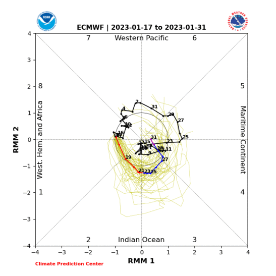
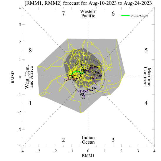
With the MJO being forecast to remain distant from the WPAC, this likely means we won't see any substantial WWBs in the near future to keep the Niño regions this warm and/or warm them up some more, not to mention another prolonged trade burst is currently occuring at the Date Line which will only help to reinforce the cold pool.

Image
Image
Image

Image
6 likes   
Floyd 1999 | Isabel 2003 | Hanna 2008 | Irene 2011 | Sandy 2012 | Isaias 2020

User avatar
cycloneye
Admin
Admin
Posts: 139763
Age: 67
Joined: Thu Oct 10, 2002 10:54 am
Location: San Juan, Puerto Rico

Re: ENSO Updates

#11409 Postby cycloneye » Fri Apr 17, 2020 11:42 am

The latest update of the subsurface as of April 13 shows plenty of cool waters that has pockets of -2C. The question is when it will reach the surface.

Image
0 likes   
Visit the Caribbean-Central America Weather Thread where you can find at first post web cams,radars
and observations from Caribbean basin members Click Here

User avatar
cycloneye
Admin
Admin
Posts: 139763
Age: 67
Joined: Thu Oct 10, 2002 10:54 am
Location: San Juan, Puerto Rico

Re: ENSO Updates

#11410 Postby cycloneye » Fri Apr 17, 2020 1:03 pm

Ntxw , glad to see you in S2K again after a long absence. Waiting for your anaylsis on the state of ENSO and it's future in the next few months.
2 likes   
Visit the Caribbean-Central America Weather Thread where you can find at first post web cams,radars
and observations from Caribbean basin members Click Here

User avatar
Kingarabian
S2K Supporter
S2K Supporter
Posts: 15462
Joined: Sat Aug 08, 2009 3:06 am
Location: Honolulu, Hawaii

Re: ENSO Updates

#11411 Postby Kingarabian » Fri Apr 17, 2020 2:43 pm

cycloneye wrote:Let's see if El Niño comes as a huge surprise by ASO and all the forecasts by the experts bust bigtime. :D I am dreaming right? At the moment all the four areas are going up and three of them are above +0.5C or steady around that.

[url]https://i.imgur.com/IByL5kz.png[url]

[url]https://i.imgur.com/65p2cpY.png[url]

[url]https://i.imgur.com/U5JMgVX.png[url]

[url]https://i.imgur.com/aCm5B2u.png[url]


The SOI is down and that is good to have El Niño.


https://i.imgur.com/brwZ6pc.png

The only thing that is notable is the subsurface that is cool but so far it has not translated to the surface.

So what will be the trigger(s) to reverse all the above apart from the subsurface?

That's just a combo of the last downwelling Kelvin wave from February surfacing, along with weakened trades over most of the EPAC, and satellite derived SST's being noisy. It can take 2-3 months for a downwelling Kelvin to move from the WPAC->EPAC and fully breach the surface. The present upwelling Kelvin wave will start to breach by the end of May and will last well into June. Also a new upwelling Kelvin wave will likely be triggered as a result of this present phase of above average trades near the dateline. Euro and the GFS show relaxed trades over the dateline by April 26 though. So we're sorta seeing a chain reaction begin now which will act as foundation for cool neutral come summer time.
3 likes   
RIP Kobe Bryant

User avatar
Kingarabian
S2K Supporter
S2K Supporter
Posts: 15462
Joined: Sat Aug 08, 2009 3:06 am
Location: Honolulu, Hawaii

Re: ENSO Updates

#11412 Postby Kingarabian » Fri Apr 17, 2020 2:57 pm

Part of the reason why I think La Nina will probably need to wait till the fall:
Image


^ Hovmoller is from Mike Ventrice

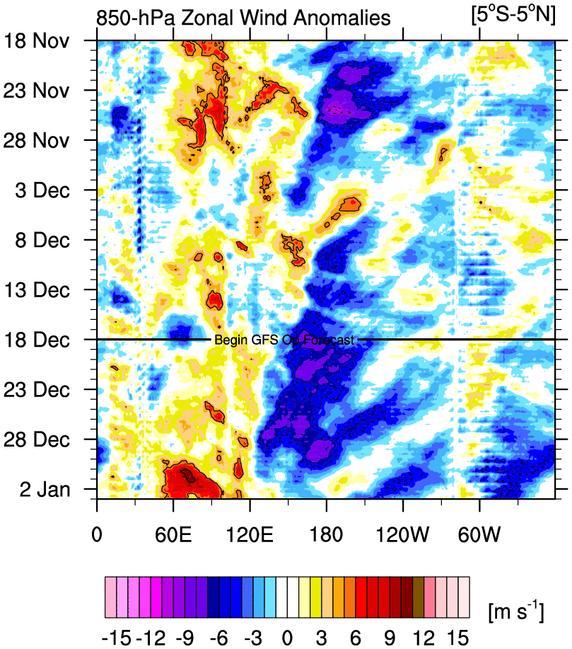
Trades have consistently been close normal. 2016 and 2017 our most recent La Nina years had much more robust trade bursts. I think this will start to occur in June and July.
2 likes   
RIP Kobe Bryant

User avatar
cycloneye
Admin
Admin
Posts: 139763
Age: 67
Joined: Thu Oct 10, 2002 10:54 am
Location: San Juan, Puerto Rico

Re: ENSO Updates

#11413 Postby cycloneye » Sat Apr 18, 2020 7:14 pm

From the NHC discussion about the trades by next week.

High pressure will then
build N of the forecast area, strengthening tradewinds W of 130W.
1 likes   
Visit the Caribbean-Central America Weather Thread where you can find at first post web cams,radars
and observations from Caribbean basin members Click Here

User avatar
Kingarabian
S2K Supporter
S2K Supporter
Posts: 15462
Joined: Sat Aug 08, 2009 3:06 am
Location: Honolulu, Hawaii

Re: ENSO Updates

#11414 Postby Kingarabian » Sat Apr 18, 2020 9:00 pm

cycloneye wrote:From the NHC discussion about the trades by next week.

High pressure will then
build N of the forecast area, strengthening tradewinds W of 130W.

I think they're talking about the high west or south west of Baja. I don't think that'll influence trades near the equator. But it'll probably help push the EPO positive and support the -PDO signature by cooling waters there.
1 likes   
RIP Kobe Bryant

User avatar
Kingarabian
S2K Supporter
S2K Supporter
Posts: 15462
Joined: Sat Aug 08, 2009 3:06 am
Location: Honolulu, Hawaii

Re: ENSO Updates

#11415 Postby Kingarabian » Sun Apr 19, 2020 10:51 pm

BOM has Nino 3.4 up to +0.58C. Will likely mean CPC will have +0.5C again this week. And so for the ONI, FMA is probably on its way to +0.5C which would mean 5 tri-monthlies in a row of +0.5C. So that would indicate 2019-2020 can qualify as an El Nino.
0 likes   
RIP Kobe Bryant

WeatherEmperor
S2K Supporter
S2K Supporter
Posts: 4806
Age: 40
Joined: Thu Sep 04, 2003 2:54 pm
Location: South Florida

Re: ENSO Updates

#11416 Postby WeatherEmperor » Mon Apr 20, 2020 9:12 am

Kingarabian wrote:BOM has Nino 3.4 up to +0.58C. Will likely mean CPC will have +0.5C again this week. And so for the ONI, FMA is probably on its way to +0.5C which would mean 5 tri-monthlies in a row of +0.5C. So that would indicate 2019-2020 can qualify as an El Nino.

CPC has it even warmer at +0.7C. I know the models keep indicating it will drop to cool-neautral by Summer/Fall but how confident are we in this if temps keep rising like this?


Sent from my iPhone using Tapatalk
0 likes   

User avatar
cycloneye
Admin
Admin
Posts: 139763
Age: 67
Joined: Thu Oct 10, 2002 10:54 am
Location: San Juan, Puerto Rico

Re: ENSO Updates

#11417 Postby cycloneye » Mon Apr 20, 2020 9:29 am

This adds to WeatherEmperor question that he posted above.

 https://twitter.com/jnmet/status/1252242486979899392


1 likes   
Visit the Caribbean-Central America Weather Thread where you can find at first post web cams,radars
and observations from Caribbean basin members Click Here

User avatar
cycloneye
Admin
Admin
Posts: 139763
Age: 67
Joined: Thu Oct 10, 2002 10:54 am
Location: San Juan, Puerto Rico

Re: ENSO Updates

#11418 Postby cycloneye » Mon Apr 20, 2020 9:42 am

Image
2 likes   
Visit the Caribbean-Central America Weather Thread where you can find at first post web cams,radars
and observations from Caribbean basin members Click Here

User avatar
cycloneye
Admin
Admin
Posts: 139763
Age: 67
Joined: Thu Oct 10, 2002 10:54 am
Location: San Juan, Puerto Rico

Re: ENSO Updates: CPC weekly update: Niño 3.4 up to +0.7C

#11419 Postby cycloneye » Mon Apr 20, 2020 9:51 am

Despite the +0.7C reading in the CPC update,the ocean is cooling at the subsurface.

Image
0 likes   
Visit the Caribbean-Central America Weather Thread where you can find at first post web cams,radars
and observations from Caribbean basin members Click Here

Chris90
Category 2
Category 2
Posts: 640
Age: 34
Joined: Thu Jun 01, 2017 9:36 pm

Re: ENSO Updates: CPC weekly update: Niño 3.4 up to +0.7C

#11420 Postby Chris90 » Mon Apr 20, 2020 3:56 pm

I think warm SST anomalies will persist for a few more weeks in all likelihood due to the fact that the top of the subsurface still has widespread warm anomalies down to roughly 50-75m across much of the ENSO regions, so slight additional warming in the shorter term can't be ruled out in my opinion. To sustain or increase these warm anomalies all the way through to ASO and the peak of hurricane season though we're going to need to see some westerly wind events that trigger a downwelling Kelvin Wave. I'm not sure that is in the cards. I'm guessing 3.4 will be somewhere around -0.3 to -0.5 for ASO, I'm in the cool neutral camp, for now anyways.
1 likes   
Solar Aquarian
Lunar Cancerian
:uarrow: Sagittarian


Return to “Talkin' Tropics”

Who is online

Users browsing this forum: JaviT, kenayers, NotSparta, zzzh and 47 guests