ENSO Updates (2007 thru 2023)

This is the general tropical discussion area. Anyone can take their shot at predicting a storms path.

Moderator: S2k Moderators

Forum rules

The posts in this forum are NOT official forecasts and should not be used as such. They are just the opinion of the poster and may or may not be backed by sound meteorological data. They are NOT endorsed by any professional institution or STORM2K. For official information, please refer to products from the National Hurricane Center and National Weather Service.

Help Support Storm2K
Message
Author
User avatar
Kingarabian
S2K Supporter
S2K Supporter
Posts: 15462
Joined: Sat Aug 08, 2009 3:06 am
Location: Honolulu, Hawaii

Re: ENSO Updates

#11981 Postby Kingarabian » Wed May 05, 2021 10:18 am

May Euro seasonal:

Nino 3.4:
Image

ASO SSTs:
Image

The Nino 3.4 forecast for May appears to be favoring warm-neutral more than the SST graphic, before dipping back towards cool neutral by the fall. The May Nino 3.4 plume also has much more spread between the members compared to the April and March forecasts.
2 likes   
RIP Kobe Bryant

User avatar
JetFuel_SE
Category 1
Category 1
Posts: 279
Age: 24
Joined: Thu Apr 30, 2020 3:57 pm

Re: ENSO Updates

#11982 Postby JetFuel_SE » Wed May 05, 2021 11:50 am

Kingarabian wrote:May Euro seasonal:

Nino 3.4:
https://i.postimg.cc/bv4Mk08f/image.png

ASO SSTs:
https://i.postimg.cc/G274Xp7R/image.png

The Nino 3.4 forecast for May appears to be favoring warm-neutral more than the SST graphic, before dipping back towards cool neutral by the fall. The May Nino 3.4 plume also has much more spread between the members compared to the April and March forecasts.

Wonder if advancements in quantum computers could help with breaking down the SPB, cause this is slightly infuriating. Like how are you gonna make a forecast when the spread is over 2°C

Also that's not SSTs, it's the air temperature at two meters up.
1 likes   

USTropics
Category 5
Category 5
Posts: 2422
Joined: Sun Aug 12, 2007 3:45 am
Location: Florida State University

Re: ENSO Updates

#11983 Postby USTropics » Wed May 05, 2021 12:01 pm

Here is the ECMWF SSTA May forecast for ASO:

Image
0 likes   

User avatar
Kingarabian
S2K Supporter
S2K Supporter
Posts: 15462
Joined: Sat Aug 08, 2009 3:06 am
Location: Honolulu, Hawaii

Re: ENSO Updates

#11984 Postby Kingarabian » Wed May 05, 2021 2:49 pm

JetFuel_SE wrote:
Kingarabian wrote:May Euro seasonal:

Nino 3.4:
https://i.postimg.cc/bv4Mk08f/image.png

ASO SSTs:
https://i.postimg.cc/G274Xp7R/image.png

The Nino 3.4 forecast for May appears to be favoring warm-neutral more than the SST graphic, before dipping back towards cool neutral by the fall. The May Nino 3.4 plume also has much more spread between the members compared to the April and March forecasts.

Wonder if advancements in quantum computers could help with breaking down the SPB, cause this is slightly infuriating. Like how are you gonna make a forecast when the spread is over 2°C

Also that's not SSTs, it's the air temperature at two meters up.

Yeah but it usually is a good indicator of the rough temperatures at the sea surface.
4 likes   
RIP Kobe Bryant

User avatar
DorkyMcDorkface
Category 2
Category 2
Posts: 743
Age: 26
Joined: Mon Sep 30, 2019 1:32 pm
Location: Mid-Atlantic

Re: ENSO Updates

#11985 Postby DorkyMcDorkface » Fri May 07, 2021 2:51 pm

NMME in for May. Cool-neutral consensus for the summer with a possible double-dip Niña by the fall/winter:
Image
Image
5 likes   
Floyd 1999 | Isabel 2003 | Hanna 2008 | Irene 2011 | Sandy 2012 | Isaias 2020

User avatar
Kingarabian
S2K Supporter
S2K Supporter
Posts: 15462
Joined: Sat Aug 08, 2009 3:06 am
Location: Honolulu, Hawaii

Re: ENSO Updates

#11986 Postby Kingarabian » Fri May 07, 2021 3:49 pm

Very positive SOI for the past 5 days and will likely continue for the next few days.

A moderate strength CCKW passing through the Pacific will open up the possibility for a short term WWB around the dateline. CFS and the Canadian agree on this scenario while the Euro and GFS do not.
Image

Other than that, above average trade winds centered over the dateline will continue for the majority of May.

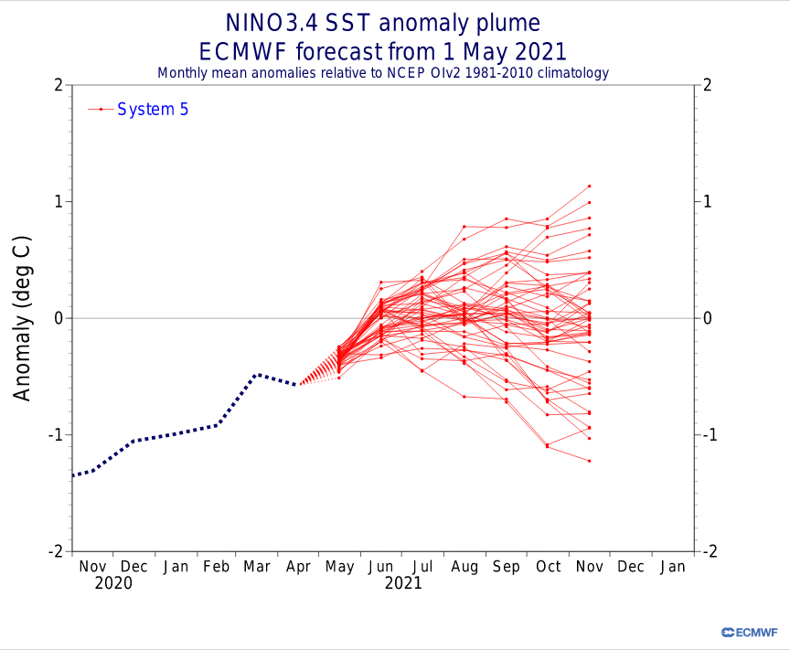
Looking ahead, this ongoing trade burst must create upwelling and stop these downwelling KW's. Because it's looking increasingly likely that there will be a strong MJO and likely a WWB over the WPAC by the end of May, which would eventually re-enforce subsurface warming down the line.
3 likes   
RIP Kobe Bryant

User avatar
Kingarabian
S2K Supporter
S2K Supporter
Posts: 15462
Joined: Sat Aug 08, 2009 3:06 am
Location: Honolulu, Hawaii

Re: ENSO Updates

#11987 Postby Kingarabian » Fri May 07, 2021 3:58 pm


Dang that NASA model only predicts strong La Nina's it seems.
2 likes   
RIP Kobe Bryant

User avatar
DorkyMcDorkface
Category 2
Category 2
Posts: 743
Age: 26
Joined: Mon Sep 30, 2019 1:32 pm
Location: Mid-Atlantic

Re: ENSO Updates

#11988 Postby DorkyMcDorkface » Fri May 07, 2021 4:00 pm

Kingarabian wrote:


Dang that NASA model only predicts strong La Nina's it seems.

Yeah tbf it is kinda skewing it more negative than it probably will be.
0 likes   
Floyd 1999 | Isabel 2003 | Hanna 2008 | Irene 2011 | Sandy 2012 | Isaias 2020

User avatar
Iceresistance
Category 5
Category 5
Posts: 8931
Age: 20
Joined: Sat Oct 10, 2020 9:45 am
Location: Tecumseh, OK/Norman, OK

Re: ENSO Updates

#11989 Postby Iceresistance » Fri May 07, 2021 4:13 pm


Not again! This past winter was NASTY with a La Niña! As well as the Atlantic Hurricane Season!
0 likes   
Bill 2015 & Beta 2020

Winter 2020-2021 :cold:

All observations are in Tecumseh, OK unless otherwise noted.

Winter posts are focused mainly for Oklahoma & Texas.

Take any of my forecasts with a grain of salt, refer to the NWS, SPC, and NHC for official information

Never say Never with weather! Because ANYTHING is possible!

User avatar
Kingarabian
S2K Supporter
S2K Supporter
Posts: 15462
Joined: Sat Aug 08, 2009 3:06 am
Location: Honolulu, Hawaii

Re: ENSO Updates

#11990 Postby Kingarabian » Fri May 07, 2021 4:17 pm

Iceresistance wrote:

Not again! This past winter was NASTY with a La Niña! As well as the Atlantic Hurricane Season!


I would... try to eyeball the mean average without the NASA model forecast. It would be more in line with the other forecasts.
4 likes   
RIP Kobe Bryant

User avatar
Kingarabian
S2K Supporter
S2K Supporter
Posts: 15462
Joined: Sat Aug 08, 2009 3:06 am
Location: Honolulu, Hawaii

Re: ENSO Updates

#11991 Postby Kingarabian » Fri May 07, 2021 4:30 pm

A +PMM signature is slowly trying to materialize. This is a feature that is usually missing in years where El Nino/warm-neutral attempts fail.

Image
Image
Image
2 likes   
RIP Kobe Bryant

User avatar
Kingarabian
S2K Supporter
S2K Supporter
Posts: 15462
Joined: Sat Aug 08, 2009 3:06 am
Location: Honolulu, Hawaii

Re: ENSO Updates

#11992 Postby Kingarabian » Fri May 07, 2021 5:21 pm

Another indicator (although it's not really factored much), the IOD is usually negative during La Nina events. It has come in more positive as of late.
 https://twitter.com/WorldClimateSvc/status/1389663595278049283


During El Niño, the anomalous (departure from average) surface winds near Indonesia blow from southeast to northwest, helping to bring cold water to the surface near Java and Sumatra and initiating a positive IOD event, like what we saw with the extreme IOD event of 1997. Similarly, La Niña tends to trigger negative IOD events.
0 likes   
RIP Kobe Bryant

User avatar
Iceresistance
Category 5
Category 5
Posts: 8931
Age: 20
Joined: Sat Oct 10, 2020 9:45 am
Location: Tecumseh, OK/Norman, OK

Re: ENSO Updates

#11993 Postby Iceresistance » Fri May 07, 2021 5:27 pm

Nino 1+2 has REALLY cooled down . . .

Image
0 likes   
Bill 2015 & Beta 2020

Winter 2020-2021 :cold:

All observations are in Tecumseh, OK unless otherwise noted.

Winter posts are focused mainly for Oklahoma & Texas.

Take any of my forecasts with a grain of salt, refer to the NWS, SPC, and NHC for official information

Never say Never with weather! Because ANYTHING is possible!

User avatar
NotSparta
Professional-Met
Professional-Met
Posts: 1660
Age: 22
Joined: Fri Aug 18, 2017 8:24 am
Location: Naples, FL
Contact:

Re: ENSO Updates

#11994 Postby NotSparta » Sat May 08, 2021 12:03 am

Kingarabian wrote:A +PMM signature is slowly trying to materialize. This is a feature that is usually missing in years where El Nino/warm-neutral attempts fail.

https://i.imgur.com/n27tjvf.png
https://i.imgur.com/hJPihud.png
https://i.imgur.com/ZpY0CrF.png


I believe usually successful +PMMs (that create +ENSO) show up around the equinox. A little late now. At least the Atlantic isn't warm which means no roadblock there
4 likes   
This post was probably an opinion of mine, and in no way is official. Please refer to http://www.hurricanes.gov for official tropical analysis and advisories.

My website, with lots of tropical wx graphics, including satellite and recon: http://cyclonicwx.com

User avatar
DorkyMcDorkface
Category 2
Category 2
Posts: 743
Age: 26
Joined: Mon Sep 30, 2019 1:32 pm
Location: Mid-Atlantic

Re: ENSO Updates

#11995 Postby DorkyMcDorkface » Sun May 09, 2021 3:18 pm

MJO forcing in the Indian Ocean will likely induce a powerful westerly wind burst there (and a subsequent TC or two). Given that this corresponds with enhanced easterlies in the Pacific, this tells me that the Walker Circulation is still coupled with negative ENSO of some sort. An event like this would likely help to send in reinforcements to the current background state.
Image
Image
7 likes   
Floyd 1999 | Isabel 2003 | Hanna 2008 | Irene 2011 | Sandy 2012 | Isaias 2020

User avatar
Kingarabian
S2K Supporter
S2K Supporter
Posts: 15462
Joined: Sat Aug 08, 2009 3:06 am
Location: Honolulu, Hawaii

Re: ENSO Updates

#11996 Postby Kingarabian » Sun May 09, 2021 7:53 pm

:uarrow: The present MJO signal over the IO will likely adjust the -VP200 90 day average closer to the MC; per NotSparta's graphs it looks like the Walker Cell rising branch is currently situated between 150E-160E:

Image

Sorta similar to 2018 so far in terms of rising motion, just without the warm north east Pacific waters.

Image
Image
5 likes   
RIP Kobe Bryant

USTropics
Category 5
Category 5
Posts: 2422
Joined: Sun Aug 12, 2007 3:45 am
Location: Florida State University

Re: ENSO Updates

#11997 Postby USTropics » Sun May 09, 2021 10:01 pm

Kingarabian wrote::uarrow: The present MJO signal over the IO will likely adjust the -VP200 90 day average closer to the MC; per NotSparta's graphs it looks like the Walker Cell rising branch is currently situated between 150E-160E:

https://i.imgur.com/L7afGJO.png

Sorta similar to 2018 so far in terms of rising motion, just without the warm north east Pacific waters.

https://i.imgur.com/QuYD4cr.png
https://i.imgur.com/psVL2HL.png


There is a bit of a discrepancy between using anomalies and a composite mean. Your statement is still accurate, but here is a more apples to apples comparison from the past 30 years:

Image

Image

Image

Image

Image

Image

Image

Image

Image

Image

Image

Image

Image

Image

Image

Image

Image

Image

Image

Image

Image

Image

Image

Image

Image

Image

Image

Image

Image

Image

Image

Composite link - https://imgur.com/a/mIbrCLW
8 likes   

User avatar
Category5Kaiju
Category 5
Category 5
Posts: 3438
Age: 22
Joined: Thu Dec 24, 2020 12:45 pm
Location: Seattle

Re: ENSO Updates

#11998 Postby Category5Kaiju » Tue May 11, 2021 7:56 am

1 likes   
Unless explicitly stated, all information covered in my posts is based on my opinions and observations. Please refer to a professional meteorologist or an accredited weather research agency otherwise, especially if serious decisions must be made in the event of a potentially life-threatening tropical storm or hurricane.

User avatar
cycloneye
Admin
Admin
Posts: 139604
Age: 67
Joined: Thu Oct 10, 2002 10:54 am
Location: San Juan, Puerto Rico

Re: ENSO Updates

#11999 Postby cycloneye » Wed May 12, 2021 8:57 am

BoM latest proyection goes to cool neutral for ASO.

http://www.bom.gov.au/climate/model-sum ... reau-model

Image
2 likes   
Visit the Caribbean-Central America Weather Thread where you can find at first post web cams,radars
and observations from Caribbean basin members Click Here

User avatar
Kingarabian
S2K Supporter
S2K Supporter
Posts: 15462
Joined: Sat Aug 08, 2009 3:06 am
Location: Honolulu, Hawaii

Re: ENSO Updates

#12000 Postby Kingarabian » Wed May 12, 2021 5:56 pm

Current trade burst is doing a good job in keeping the surface temps cooler than normal, but there's still very little upwelling at the subsurface.
Image

This is a "surface" La Nina/-ENSO presentation where the surface temperatures are cool and the subsurface is warm. This is the opposite of 2017's surface El Nino/+ENSO presentation, where the surface was much warmer than the subsurface.

Looking ahead, the models are coming into good agreement of another WPAC WWB during June. It'll likely trigger another downwelling KW if it occurs.
Image
2 likes   
RIP Kobe Bryant


Return to “Talkin' Tropics”