Gulf of Mexico (Is Invest 91L)
Moderator: S2k Moderators
Forum rules

The posts in this forum are NOT official forecasts and should not be used as such. They are just the opinion of the poster and may or may not be backed by sound meteorological data. They are NOT endorsed by any professional institution or STORM2K. For official information, please refer to products from the National Hurricane Center and National Weather Service.
-
inda_iwall
Re: Gulf of Mexico area
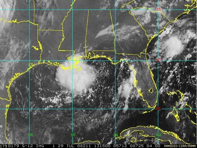
It has really blown up in convection this morning. Cant believe everyone scoffed with their noses up at us who just asked some questions about possibilities, well, can we ask again? Is this going to become something? Whats its deal out there?
0 likes


-
Ed Mahmoud
Re: Gulf of Mexico area
If there was anything near the surface, I doubt Venice-Boothville would have a West wind North of the blob.
0 likes

Re: Gulf of Mexico area
Mid-Level center near 27.5N-89W. I don't see anything working down to the surface yet.
http://www.ssd.noaa.gov/goes/east/gmex/loop-vis.html
http://www.ssd.noaa.gov/goes/east/gmex/loop-vis.html
0 likes
-
Ed Mahmoud
Re: Gulf of Mexico area
If it was at the surface, shallow steering would be straight inland. If it is mid-level, 850 to 500 mb mean steering is slightly West of due North, but again inland.
Quiet week coming up in the tropics. It'll get busy again, in my unofficial opinion, just not right away.
Quiet week coming up in the tropics. It'll get busy again, in my unofficial opinion, just not right away.
0 likes
-
ColdFusion

- S2K Supporter

- Posts: 452
- Joined: Wed Feb 13, 2008 3:46 pm
- Location: Addison, TX
Re: Gulf of Mexico area
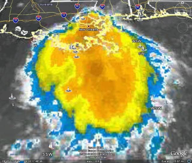
Well at first glance it sure is interesting. Went from nothing to a nice little ball of convection pretty quickly didnt it. I'll keep a vis loop open on the desktop today just to watch what happens to it. Producing some good downpours around downtown NOLA at the moment.
0 likes
Re: Gulf of Mexico area
The shape is obvious. If it's still here today from yesterday there's something to it.
0 likes
-
freeroam

- Tropical Low

- Posts: 23
- Joined: Sat Sep 11, 2004 9:45 pm
- Location: New Orleans, LA.
- Contact:
The "blob" sure looks to have grown from last night. We are getting a nice breeze and some rain here in New Orleans. I will also keep a eye on this one. This reminds me of a night my husband and I went to bed with a low hanging out in the gulf and woke up in the morning with a stong TS. I can't remember the name but I think the year was 2000. That tought me a valuable lesson about writing things off in the gulf.
0 likes
-
Ed Mahmoud
Re: Gulf of Mexico area
Sanibel wrote:The shape is obvious. If it's still here today from yesterday there's something to it.
If we had surface winds from the East on the coast, or steering didn't suggest it goes inland today or tonight, I'd be really fired up.
If that had enough time to sit and blow up storms over warm water, it would probably develop. But the lack of an East wind shows it doesn't already have a low level circulation, and its time over water is limited.
0 likes

Re: Gulf of Mexico area
[quote="Ed Mahmoud"][quote="Sanibel"]The shape is obvious. If it's still here today from yesterday there's something to it.[/quote]
If we had surface winds from the East on the coast, or steering didn't suggest it goes inland today or tonight, I'd be really fired up.
If that had enough time to sit and blow up storms over warm water, it would probably develop. But the lack of an East wind shows it doesn't already have a low level circulation, and its time over water is limited.[/quote]
I don't know how much impact, if any this would have on it but last night Mr. "Good News", Dr. Lyons mentioned that Thursday another front would dig down to the Gulf...
0 likes
-
fwbbreeze

- S2K Supporter
- Posts: 898
- Joined: Sun Mar 21, 2004 10:09 pm
- Location: Fort Walton Beach, FL
Re: Gulf of Mexico area
I don't know how much impact, if any this would have on it but last night Mr. "Good News", Dr. Lyons mentioned that Thursday another front would dig down to the Gulf...
This is from an early morning AFD out of Mobile, AL. It lends credence to what Dr. Lyons said.
.LONG TERM...(WEDNESDAY THROUGH MONDAY)DEEP TROPICAL MOISTURE
FLOWING NORTH ACROSS THE FORECAST AREA ON THE WESTERN SIDE OF HIGH
PRESSURE WILL ENSURE THAT SCATTERED TO AT TIMES NUMEROUS SHOWERS AND
THUNDERSTORMS WILL BE THE MID WEEK PATTERN. PRECIPITABLE WATER
VALUES OVER TWO INCHES THROUGH THE WEEK IN CONJUNCTION WITH WEAK
DISTURBANCES MOVING EAST IN THE MID LEVEL FLOW WILL ENHANCE THE
CONVECTION IN THE HEAT OF THE AFTERNOONS...PRODUCING LOCALIZED AREAS
OF VERY HEAVY DOWNPOURS AT TIMES. NOT MUCH OF A SURFACE LOW PRESSURE
CENTER SHOWING UP UNTIL THE WEEKEND. BY THE WEEKEND THE GFS DOES
DEPICT A WEAK SURFACE LOW DRIFTING SOUTHWESTERLY INTO THE AREA FROM
THE NORTHEAST. THIS WOULD KEEP PRECIPITATION CHANCES AROUND
CLIMATOLOGY FOR THIS TIME OF YEAR...WHICH IS AROUND 40 PERCENT.
HAVE BACKED OFF JUST A BIT ON THE HIGH TEMPERATURE FORECAST FOR
LATER IN THE WEEK AND INCREASED THE OVERNIGHT LOWS A TAD DUE TO THE
GFS`S PERSISTENCE IN SHOWING MORE RAIN AND CLOUDS LATER THIS WEEK.
/11
http://www.srh.noaa.gov/mob/productview ... &version=0
0 likes
Re: Gulf of Mexico area
N2Storms wrote:I don't know how much impact, if any this would have on it but last night Mr. "Good News", Dr. Lyons mentioned that Thursday another front would dig down to the Gulf...
Sorry if I'm drifting off topic, but I'm so glad to see that someone else shares my opinion about Mr. Good News. Meteorologists shouldn't editorialize about weather conditions; when they say things like, "there's no rain headed this way, so that's good news", I'm sure the area farmers wouldn't agree. It's one thing to find good news in the fact that a storm won't bring destruction to an area...but when he said yesterday that it was good news that this "blob" would likely dissipate [before bringing much needed rain to some areas that really need it], I didn't share his joy.
0 likes
-
Category 5

- Category 5

- Posts: 10074
- Age: 36
- Joined: Sun Feb 11, 2007 10:00 pm
- Location: New Brunswick, NJ
- Contact:
Re: Gulf of Mexico area
Sanibel wrote:The shape is obvious. If it's still here today from yesterday there's something to it.
Resembles Danny 1997.
It appears it's going to run out of time.
0 likes

Re: Gulf of Mexico area
Category 5 wrote:Sanibel wrote:The shape is obvious. If it's still here today from yesterday there's something to it.
Resembles Danny 1997.
It appears it's going to run out of time.
It sure does I think Danny hit the Mobile area.
0 likes
-
Dean4Storms
- S2K Supporter
- Posts: 6358
- Age: 63
- Joined: Sun Aug 31, 2003 1:01 pm
- Location: Miramar Bch. FL
If it was another 200 or so miles to the south it might have a chance, but it is going to run out of warm water here shortly as the flow around the ridge moves in.
Still should bring some beneficial rain to Eastern LA, S. Miss, S. Alabama and the Florida Panhandle with the surge of deep tropical moisture and PW values climbing above 2".
Still should bring some beneficial rain to Eastern LA, S. Miss, S. Alabama and the Florida Panhandle with the surge of deep tropical moisture and PW values climbing above 2".
0 likes
-
Category 5
- Category 5
- Posts: 10074
- Age: 36
- Joined: Sun Feb 11, 2007 10:00 pm
- Location: New Brunswick, NJ
- Contact:
Re: Gulf of Mexico area
boca wrote:Category 5 wrote:Sanibel wrote:The shape is obvious. If it's still here today from yesterday there's something to it.
Resembles Danny 1997.
It appears it's going to run out of time.
It sure does I think Danny hit the Mobile area.
It actually made a few landfalls. Empire LA (65kts) Fort Morgan AL (70kts) and Mullet Point AL (65kts).
Source: http://www.nhc.noaa.gov/1997danny.html
0 likes
Who is online
Users browsing this forum: Iceresistance, NotSparta and 36 guests