2012 WPAC season

This is the general tropical discussion area. Anyone can take their shot at predicting a storms path.

Moderator: S2k Moderators

Forum rules

The posts in this forum are NOT official forecasts and should not be used as such. They are just the opinion of the poster and may or may not be backed by sound meteorological data. They are NOT endorsed by any professional institution or STORM2K. For official information, please refer to products from the National Hurricane Center and National Weather Service.

Help Support Storm2K
Message
Author
euro6208

Re: 2012 WPAC season

#121 Postby euro6208 » Wed Jun 20, 2012 6:55 am

Image

possible development this week in the philippine sea while week 2 shows nothing...looks like we won't see any major storm euqivalent to guchol until july...
0 likes   

euro6208

Re: 2012 WPAC season

#122 Postby euro6208 » Wed Jun 20, 2012 11:39 am

2012 Tropical Cyclone Activity
Accumulated Cyclone Energy
Updated Jun 20, 2012 16:00

BASIN CURRENT YTD
N. Hemisphere
71.0750
Western Pacific
53.18
North Atlantic
5.7125
Eastern Pacific
12.1825
North Indian
0
Global
205.1170
*S. Hemisphere Season:
146.32
*season runs from October to June


Accumulated Cyclone Energy
1981-2010 Climatology
Calendar Year / Year To Date

BASIN NORMAL YEARLY ACE NORMAL YEAR TO DATE
Northern Hemisphere 562 51
Western North Pacific 302 35
North Atlantic 104 0
Eastern Pacific 138 7
North Indian 18 7
Southern Hemisphere* 209 209
Global 771 223


i got this from Dr. Ryan N. Maue http://policlimate.com/tropical/ and it shows each of the basin's ACE. so far the northern hemisphere has 71.0750 and the westpac has 53.18 (talim still active). the westpac sure knows how to rank up those ACE' :eek: westpac sure ahead, normal year to date is 35, already at 53...
0 likes   

dexterlabio
Category 5
Category 5
Posts: 3468
Joined: Sat Oct 24, 2009 11:50 pm

Re: 2012 WPAC season

#123 Postby dexterlabio » Thu Jun 21, 2012 8:46 am

Mawar, and Guchol especially, really raked up those ACE..


if im not mistaken, at the early part of last year's typhoon season, we also had high ACE above average for some certain time, but the considered "peak" months did not show anything significant to rake more ACE for the WPAC... this time though we might see a different scenario, if typhoon season this year started active then I bet we are gonna also end it with such high activity. The brewing El Nino could give us a different setup in the coming months.
0 likes   
Personal Forecast Disclaimer:
The posts in this forum are NOT official forecast and should not be used as such. They are just the opinion of the poster and may or may not be backed by sound meteorological data. They are NOT endorsed by any professional institution or storm2k.org. For official information, please refer to the NHC and NWS products.

dexterlabio
Category 5
Category 5
Posts: 3468
Joined: Sat Oct 24, 2009 11:50 pm

#124 Postby dexterlabio » Thu Jun 21, 2012 8:49 am

but for now it seems we're gonna see our next storm after a week or two.....Euro and GFS show just some weak low pressure systems but just that..if the MJO returns to WPAC/Maritime Continent then that will be the time, I think....
0 likes   
Personal Forecast Disclaimer:
The posts in this forum are NOT official forecast and should not be used as such. They are just the opinion of the poster and may or may not be backed by sound meteorological data. They are NOT endorsed by any professional institution or storm2k.org. For official information, please refer to the NHC and NWS products.

euro6208

Re:

#125 Postby euro6208 » Thu Jun 21, 2012 11:25 am

dexterlabio wrote:but for now it seems we're gonna see our next storm after a week or two.....Euro and GFS show just some weak low pressure systems but just that..if the MJO returns to WPAC/Maritime Continent then that will be the time, I think....


wow that was fun tracking guchol and talim alongside watching the NBA finals! here hoping oklahoma wins today :D
0 likes   

Typhoon Hunter
WesternPacificWeather.com
Posts: 1221
Joined: Wed Oct 11, 2006 11:37 am
Location: Tokyo
Contact:

Re:

#126 Postby Typhoon Hunter » Sat Jun 23, 2012 12:06 am

dexterlabio wrote:but for now it seems we're gonna see our next storm after a week or two.....Euro and GFS show just some weak low pressure systems but just that..if the MJO returns to WPAC/Maritime Continent then that will be the time, I think....


Yeah I won't be surprised if we have to wait 10 days + for our next big player given the MJO and model outlook. Suits me since I've got lots of Euro 2012 football to watch and quite a bit of filming work on next week!
0 likes   
James - Documenting tropical cyclones...

http://www.youtube.com/TyphoonHunter

dexterlabio
Category 5
Category 5
Posts: 3468
Joined: Sat Oct 24, 2009 11:50 pm

Re: 2012 WPAC season

#127 Postby dexterlabio » Sat Jun 23, 2012 9:17 am

i could be wrong James. :lol: i've always admitted im a euro fanboy so anything "consistent" it shows always gets my attention. its previous runs only indicated weak lows but the latest run finally shows a decent system 5 days from now. i cant help but to rely mostly on it, it's been doing good at short to mid-range forecasts. its initial forecasts on Guchol's intensity was a bummer though. :lol:
0 likes   
Personal Forecast Disclaimer:
The posts in this forum are NOT official forecast and should not be used as such. They are just the opinion of the poster and may or may not be backed by sound meteorological data. They are NOT endorsed by any professional institution or storm2k.org. For official information, please refer to the NHC and NWS products.

dexterlabio
Category 5
Category 5
Posts: 3468
Joined: Sat Oct 24, 2009 11:50 pm

Re: 2012 WPAC season

#128 Postby dexterlabio » Sat Jun 23, 2012 9:18 am

the other models (GFS, CMC, UKMET, NOGAPS, etc) been hinting low pressure system developing but just barely a TC. still my bias self focuses on Euro and see if they will consistently show that scenario.

Image

EURO 2300z. extended run shows it hitting south of China (maybe HK?) as a weak system.

Image
Image
Image
Image
Last edited by dexterlabio on Sat Jun 23, 2012 9:25 am, edited 1 time in total.
0 likes   
Personal Forecast Disclaimer:
The posts in this forum are NOT official forecast and should not be used as such. They are just the opinion of the poster and may or may not be backed by sound meteorological data. They are NOT endorsed by any professional institution or storm2k.org. For official information, please refer to the NHC and NWS products.

dexterlabio
Category 5
Category 5
Posts: 3468
Joined: Sat Oct 24, 2009 11:50 pm

#129 Postby dexterlabio » Sat Jun 23, 2012 9:23 am

lol euro i was rooting for heat to win the championship for i was quite disappointed on how last year's finals turned out. still a good job for durant and thunder, they'll definitely have a shot next season.
0 likes   
Personal Forecast Disclaimer:
The posts in this forum are NOT official forecast and should not be used as such. They are just the opinion of the poster and may or may not be backed by sound meteorological data. They are NOT endorsed by any professional institution or storm2k.org. For official information, please refer to the NHC and NWS products.

euro6208

Re:

#130 Postby euro6208 » Sat Jun 23, 2012 11:14 am

dexterlabio wrote:lol euro i was rooting for heat to win the championship for i was quite disappointed on how last year's finals turned out. still a good job for durant and thunder, they'll definitely have a shot next season.


yes i am disappointed that my thunder team took on lebron and the referees...clearly the refs were on their side lol...but anyways, doksuri should be here in the next few days...
0 likes   

euro6208

Re: 2012 WPAC season

#131 Postby euro6208 » Sun Jun 24, 2012 10:41 am

lol...im watching debby and im thinking to my head that this is a wpac system. the highest dvorak estimate is only around 35 knots...wow! if this was in the west pacific, we will never know how strong it is (probrably only 35 knots from JTWC and JMA in agreement with dvorak) but look recon found 50 knots! 8-) it goes to show that dvorak estimates are always low and that true intensities can only be measured by recon...
0 likes   

dexterlabio
Category 5
Category 5
Posts: 3468
Joined: Sat Oct 24, 2009 11:50 pm

#132 Postby dexterlabio » Tue Jun 26, 2012 2:27 am

i also tend to base the intensity to the appearance of a storm. If Debby is a TS in ATL then maybe we'll have it as a mere invest in WPAC based on its overall structure.

by the way, I know we have a brewing TC right now but recently models are coming into agreement again about another low pressure system developing. though euro doesn't show anything significant yet in the long range. once euro joins the pack (NOGAPS, CMC, especially GFS) then i will probably be cautious about it.

Image
0 likes   
Personal Forecast Disclaimer:
The posts in this forum are NOT official forecast and should not be used as such. They are just the opinion of the poster and may or may not be backed by sound meteorological data. They are NOT endorsed by any professional institution or storm2k.org. For official information, please refer to the NHC and NWS products.

euro6208

Re:

#133 Postby euro6208 » Tue Jun 26, 2012 10:38 am

dexterlabio wrote:i also tend to base the intensity to the appearance of a storm. If Debby is a TS in ATL then maybe we'll have it as a mere invest in WPAC based on its overall structure.

by the way, I know we have a brewing TC right now but recently models are coming into agreement again about another low pressure system developing. though euro doesn't show anything significant yet in the long range. once euro joins the pack (NOGAPS, CMC, especially GFS) then i will probably be cautious about it.

Image


interesting..a system develops southeast of guam near the equator and moves to the philippine sea...looks like another *monster*.
0 likes   

dexterlabio
Category 5
Category 5
Posts: 3468
Joined: Sat Oct 24, 2009 11:50 pm

Re: 2012 WPAC season

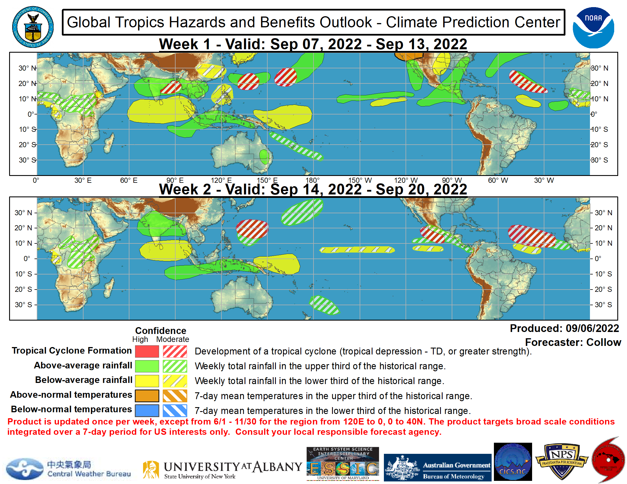
#134 Postby dexterlabio » Wed Jun 27, 2012 6:17 am

Climate Prediction Center now also predicts TC formation in Philippine Sea and even in SCS for next week or so according to their global tropical hazards outlook.

Image
0 likes   
Personal Forecast Disclaimer:
The posts in this forum are NOT official forecast and should not be used as such. They are just the opinion of the poster and may or may not be backed by sound meteorological data. They are NOT endorsed by any professional institution or storm2k.org. For official information, please refer to the NHC and NWS products.

euro6208

Re: 2012 WPAC season

#135 Postby euro6208 » Wed Jun 27, 2012 7:48 am

seems like the area around the philippines is a magnet this year.
0 likes   

Typhoon Hunter
WesternPacificWeather.com
Posts: 1221
Joined: Wed Oct 11, 2006 11:37 am
Location: Tokyo
Contact:

Re: 2012 WPAC season

#136 Postby Typhoon Hunter » Thu Jun 28, 2012 2:55 am

That's interesting Dexter, must be Invest 96W? Other than that I'm not seeing much in the long range to suggest SCS formation next week.
0 likes   
James - Documenting tropical cyclones...

http://www.youtube.com/TyphoonHunter

dexterlabio
Category 5
Category 5
Posts: 3468
Joined: Sat Oct 24, 2009 11:50 pm

Re: 2012 WPAC season

#137 Postby dexterlabio » Thu Jun 28, 2012 3:15 am

^Well I suppose that's it. :lol: 96W is looking good right now. I'm not also sure about the SCS formation but that could also pertain to 96W which has a chance to enter SCS late next week. By the way euro now hints a low pressure system and tracks it off Luzon on the 4th of July, but still keeping it very weak... Other models also still showing the same, with GFS having a decent TC tracking towards Southern Luzon.
0 likes   
Personal Forecast Disclaimer:
The posts in this forum are NOT official forecast and should not be used as such. They are just the opinion of the poster and may or may not be backed by sound meteorological data. They are NOT endorsed by any professional institution or storm2k.org. For official information, please refer to the NHC and NWS products.

euro6208

Re: 2012 WPAC season

#138 Postby euro6208 » Thu Jun 28, 2012 11:42 am

an anticyclone has developed over 96W...potential for development is now high...
0 likes   

euro6208

Re: 2012 WPAC season

#139 Postby euro6208 » Sat Jun 30, 2012 11:55 pm

euro doesn't show anything developing in the near future...
0 likes   

euro6208

Re: 2012 WPAC season

#140 Postby euro6208 » Mon Jul 02, 2012 10:47 am

el nino is here! looks like the west pacific is starting to react as convection is blowing up all over the place even to the international dateline...
0 likes   


Return to “Talkin' Tropics”

Who is online

Users browsing this forum: Google [Bot], jaguars_22, Pas_Bon, TomballEd and 52 guests