Gulf Coast Disturbance (early August)

This is the general tropical discussion area. Anyone can take their shot at predicting a storms path.

Moderator: S2k Moderators

Forum rules

The posts in this forum are NOT official forecasts and should not be used as such. They are just the opinion of the poster and may or may not be backed by sound meteorological data. They are NOT endorsed by any professional institution or STORM2K. For official information, please refer to products from the National Hurricane Center and National Weather Service.

Help Support Storm2K
Message
Author
bamajammer4eva
Category 4
Category 4
Posts: 907
Joined: Sun Apr 18, 2010 3:21 am
Location: Ozark, AL

Re: Northeastern Gulf of Mexico

#121 Postby bamajammer4eva » Fri Aug 05, 2016 11:52 pm

Alyono wrote:for the first time, the Canadian is developing this

UKMET has dropped it in favor of development east of Florida. Of course, Canadian develops BOTH


Canadian showing at least some consistency since the 12z showed something similar

Image

This is the same timeframe on the 00z for next Thur morning. It develops the NE gulf system and already moved it well inland with a 2nd system inbound for later on.

Image
0 likes   

User avatar
Steve
S2K Supporter
S2K Supporter
Posts: 9620
Joined: Sat Apr 05, 2003 11:41 pm
Location: Not a state-caster

Re: Northeastern Gulf of Mexico

#122 Postby Steve » Sat Aug 06, 2016 12:12 am

Gfs doesn't do much, it just lingers
0 likes   

bamajammer4eva
Category 4
Category 4
Posts: 907
Joined: Sun Apr 18, 2010 3:21 am
Location: Ozark, AL

Re: Northeastern Gulf of Mexico

#123 Postby bamajammer4eva » Sat Aug 06, 2016 1:12 am

Image

Last 4 Tropical outlooks keep nudging this eastward towards the Atlantic. Wasnt it said latest UKMET favored this developing in the Atlantic instead of the gulf? Most models seem to randomly place Lows so anything may be possible!

Latest outlook

TROPICAL WEATHER OUTLOOK
NWS NATIONAL HURRICANE CENTER MIAMI FL
200 AM EDT SAT AUG 6 2016

For the North Atlantic...Caribbean Sea and the Gulf of Mexico:

The National Hurricane Center is issuing advisories on Tropical
Storm Earl, located near Veracruz, Mexico.

1. An area of cloudiness and thunderstorms associated with a trough of
low pressure is located over the northeastern Gulf of Mexico. If
the disturbance remains over water, some gradual development is
possible while it meanders near the coasts of the eastern Florida
panhandle and the northern Florida peninsula during the next few
days.
* Formation chance through 48 hours...low...20 percent
* Formation chance through 5 days...low...30 percent

Forecaster Beven
0 likes   

psyclone
S2K Supporter
S2K Supporter
Posts: 4762
Joined: Wed Aug 24, 2005 9:04 pm
Location: palm harbor fl

Re: Northeastern Gulf of Mexico

#124 Postby psyclone » Sat Aug 06, 2016 4:30 am

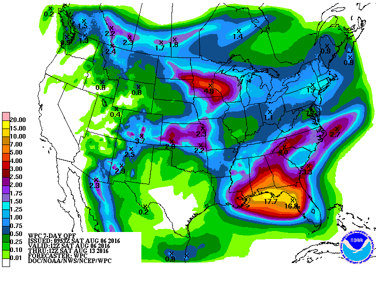
:eek: The HPC QPF maps just stepped it up another notch..
1 likes   

User avatar
cycloneye
Admin
Admin
Posts: 145277
Age: 68
Joined: Thu Oct 10, 2002 10:54 am
Location: San Juan, Puerto Rico

Re: Northeastern Gulf of Mexico

#125 Postby cycloneye » Sat Aug 06, 2016 6:56 am

An area of cloudiness and thunderstorms associated with a trough of
low pressure is located over the northeastern Gulf of Mexico. Some
gradual development is possible before the system moves inland over
the southeastern United States in a couple of days. Regardless of
development, heavy rainfall over northern Florida is anticipated.
* Formation chance through 48 hours...low...20 percent
* Formation chance through 5 days...low...30 percent
0 likes   
Visit the Caribbean-Central America Weather Thread where you can find at first post web cams,radars
and observations from Caribbean basin members Click Here

User avatar
N2FSU
S2K Supporter
S2K Supporter
Posts: 1062
Joined: Thu Sep 04, 2003 2:04 pm
Location: Tallahassee, FL

Re: Northeastern Gulf of Mexico

#126 Postby N2FSU » Sat Aug 06, 2016 7:50 am

psyclone wrote::eek: The HPC QPF maps just stepped it up another notch..


Image
0 likes   

User avatar
NDG
S2K Supporter
S2K Supporter
Posts: 15446
Joined: Sun Jul 09, 2006 10:14 pm
Location: Orlando, FL

Re: Northeastern Gulf of Mexico

#127 Postby NDG » Sat Aug 06, 2016 7:54 am

I wouldn't doubt this forecast, the Euro probably paints even higher precip totals for the Nature coast by looking at its run from last night.

Image
0 likes   

User avatar
NDG
S2K Supporter
S2K Supporter
Posts: 15446
Joined: Sun Jul 09, 2006 10:14 pm
Location: Orlando, FL

Re: Northeastern Gulf of Mexico

#128 Postby NDG » Sat Aug 06, 2016 8:04 am

Very noticeable vorticity over the Bay this morning.

Image
1 likes   

User avatar
tropicwatch
Category 5
Category 5
Posts: 3383
Age: 61
Joined: Sat Jun 02, 2007 10:01 am
Location: Panama City Florida
Contact:

Re: Northeastern Gulf of Mexico

#129 Postby tropicwatch » Sat Aug 06, 2016 8:05 am

:uarrow: Could be a beginning.
1 likes   
Tropicwatch


Agnes 72', Eloise 75, Elena 85', Kate 85', Charley 86', Florence 88', Beryl 94', Dean 95', Erin 95', Opal 95', Earl 98', Georges 98', Ivan 2004', Arlene 2005', Dennis 2005', Ida 2009' Debby 2012' Irma 2017' Michael 2018'

User avatar
ronjon
Category 5
Category 5
Posts: 4822
Joined: Fri Aug 19, 2005 5:17 pm
Location: Hernando Beach, FL

Re: Northeastern Gulf of Mexico

#130 Postby ronjon » Sat Aug 06, 2016 8:19 am

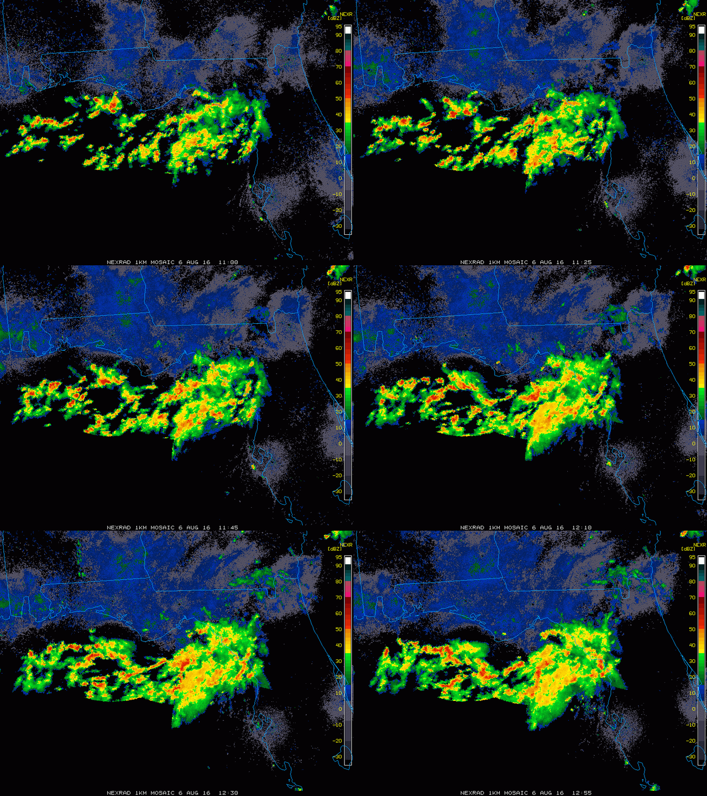
Looks like a broad weak low beginning to form off the coast of Dixie and Taylor counties in Fl based on Radar.
0 likes   

Dean4Storms
S2K Supporter
S2K Supporter
Posts: 6358
Age: 62
Joined: Sun Aug 31, 2003 1:01 pm
Location: Miramar Bch. FL

Re: Northeastern Gulf of Mexico

#131 Postby Dean4Storms » Sat Aug 06, 2016 8:25 am

:uarrow: That is the Vort we saw yesterday between PC and Tally, very slow drift ESE.
0 likes   

User avatar
tropicwatch
Category 5
Category 5
Posts: 3383
Age: 61
Joined: Sat Jun 02, 2007 10:01 am
Location: Panama City Florida
Contact:

Re: Northeastern Gulf of Mexico

#132 Postby tropicwatch » Sat Aug 06, 2016 8:39 am

A different look at it.

Image
0 likes   
Tropicwatch


Agnes 72', Eloise 75, Elena 85', Kate 85', Charley 86', Florence 88', Beryl 94', Dean 95', Erin 95', Opal 95', Earl 98', Georges 98', Ivan 2004', Arlene 2005', Dennis 2005', Ida 2009' Debby 2012' Irma 2017' Michael 2018'

Dean4Storms
S2K Supporter
S2K Supporter
Posts: 6358
Age: 62
Joined: Sun Aug 31, 2003 1:01 pm
Location: Miramar Bch. FL

Re: Northeastern Gulf of Mexico

#133 Postby Dean4Storms » Sat Aug 06, 2016 10:06 am

You do a tour of the buoy sites right along the extreme NE gulf coast and 42036 and SGOF1 and you have a closed Low. North wind, West wind, East and South winds!

http://www.ndbc.noaa.gov/maps/Florida.shtml
0 likes   

User avatar
northjaxpro
S2K Supporter
S2K Supporter
Posts: 8900
Joined: Mon Sep 27, 2010 11:21 am
Location: Jacksonville, FL

Re: Northeastern Gulf of Mexico

#134 Postby northjaxpro » Sat Aug 06, 2016 10:08 am

Is it just me, or does it appear that the trough axis is drifting farther S-SE into the GOM the past 6-8 hours? Also, it seems that the vort in Apalachee Bay continues its slow southest drift as well late this morning.
1 likes   
NEVER, EVER SAY NEVER in the tropics and weather in general, and most importantly, with life itself!!

________________________________________________________________________________________

Fay 2008 Beryl 2012 Debby 2012 Colin 2016 Hermine 2016 Julia 2016 Matthew 2016 Irma 2017 Dorian 2019

User avatar
gatorcane
S2K Supporter
S2K Supporter
Posts: 23691
Age: 47
Joined: Sun Mar 13, 2005 3:54 pm
Location: Boca Raton, FL

Re: Northeastern Gulf of Mexico

#135 Postby gatorcane » Sat Aug 06, 2016 10:11 am

northjaxpro wrote:Is it just me, or does it appear that the trough axis is drifting farther S-SE into the GOM the past 6-8 hours? Also, it seems that the vort in Apalachee Bay continues its slow southest drift as well late this morning.


It is not you. CIMSS 850mb vort analysis confirms.

Image
Last edited by gatorcane on Sat Aug 06, 2016 10:20 am, edited 4 times in total.
1 likes   

psyclone
S2K Supporter
S2K Supporter
Posts: 4762
Joined: Wed Aug 24, 2005 9:04 pm
Location: palm harbor fl

Re: Northeastern Gulf of Mexico

#136 Postby psyclone » Sat Aug 06, 2016 10:12 am

Notice on those HPC maps that the axis of heavy rain moves westward with time...very little additional rain for cedar key after day 5 but Panama city goes way up from day 5 to day 7. I've always envisioned this as a heavy rain event with TC development a secondary possibility. ..but if you look at the extent of the heavy rain potential this could be a big deal even in the absence of a designated TC...reiterating a point often made...we need not have a number or a name for a memorable and potentially destructive event.
2 likes   

User avatar
cycloneye
Admin
Admin
Posts: 145277
Age: 68
Joined: Thu Oct 10, 2002 10:54 am
Location: San Juan, Puerto Rico

Re: Northeastern Gulf of Mexico

#137 Postby cycloneye » Sat Aug 06, 2016 10:12 am

No missions planned at this time.

WEATHER RECONNAISSANCE FLIGHTS
CARCAH, NATIONAL HURRICANE CENTER, MIAMI, FL.
1030 AM EDT SAT 06 AUGUST 2016
SUBJECT: TROPICAL CYCLONE PLAN OF THE DAY (TCPOD)
VALID 07/1100Z TO 08/1100Z AUGUST 2016
TCPOD NUMBER.....16-072

I. ATLANTIC REQUIREMENTS
1. NEGATIVE RECONNAISSANCE REQUIREMENTS.
2. OUTLOOK FOR SUCCEEDING DAY.....NEGATIVE.
0 likes   
Visit the Caribbean-Central America Weather Thread where you can find at first post web cams,radars
and observations from Caribbean basin members Click Here

User avatar
tropicwatch
Category 5
Category 5
Posts: 3383
Age: 61
Joined: Sat Jun 02, 2007 10:01 am
Location: Panama City Florida
Contact:

Re: Northeastern Gulf of Mexico

#138 Postby tropicwatch » Sat Aug 06, 2016 10:12 am

I think the high sitting to the north of the system is starting to influence movement and will probably keep what low there is offshore.

The posts in this forum are NOT official forecasts and should not be used as such. They are just the opinion of the poster and may or may not be backed by sound meteorological data. They are NOT endorsed by any professional institution or STORM2K. For official information, please refer to products from the NHC and NWS.
0 likes   
Tropicwatch


Agnes 72', Eloise 75, Elena 85', Kate 85', Charley 86', Florence 88', Beryl 94', Dean 95', Erin 95', Opal 95', Earl 98', Georges 98', Ivan 2004', Arlene 2005', Dennis 2005', Ida 2009' Debby 2012' Irma 2017' Michael 2018'

gulf701
Tropical Depression
Tropical Depression
Posts: 65
Age: 75
Joined: Mon Jun 14, 2010 4:43 pm
Location: Wewahitchka, FL

Re: Northeastern Gulf of Mexico

#139 Postby gulf701 » Sat Aug 06, 2016 10:29 am

If anyone would like to view local weather data related to this area, here is a link that you can access. This is a Davis system we maintain at our fire station. http://www.weatherlink.com/user/saintjoebeach/
1 likes   

psyclone
S2K Supporter
S2K Supporter
Posts: 4762
Joined: Wed Aug 24, 2005 9:04 pm
Location: palm harbor fl

Re: Northeastern Gulf of Mexico

#140 Postby psyclone » Sat Aug 06, 2016 10:44 am

Something else worth noting is the relative dearth of lightning strikes in the convective mass...a good indicator of a warm, tropical, high PWAT environment capable of extremely efficient rainfall production. I'm going to make a not-so-bold prediction of some flood watches coming out with this afternoon's forecast packages.
0 likes   


Return to “Talkin' Tropics”

Who is online

Users browsing this forum: JaviT, LarryWx and 25 guests