Analysis,Models,Sat Pics of Low in Western Atlantic
Moderator: S2k Moderators
Forum rules

The posts in this forum are NOT official forecasts and should not be used as such. They are just the opinion of the poster and may or may not be backed by sound meteorological data. They are NOT endorsed by any professional institution or STORM2K. For official information, please refer to products from the National Hurricane Center and National Weather Service.


This is just starting to develop and when it does we will have much better idea of where its going. We already have coastal flood, wind and high surf advisories here in Virginia Beach. Right now its calm here but tommorow the wind is supposed to be gusting up to 40knots+. Im ready for some real waves here but the wind forecast looks bad for surfing. I just wondering if this is going to be another overhyped system.
0 likes

It's fun to watch these hybrid storms develop.
I'm wondering if the NHC will actually claim this is officially a warm core system at any time.
Hurricane preparedness week is coming soon so tropical activity would help the media hype storm supply sales.
Looking at KSAV radar it appears the tail end of the front is already pushing southeast off the coast of Georgia.
http://tinyurl.com/2ntvep
The surface low should form over fairly warm SST's.
If this were august I would forecast two areas of low pressure developing one off North Carolina and another off Georgia.
0 likes
-
Aquawind

- Category 5

- Posts: 6714
- Age: 62
- Joined: Mon Jun 16, 2003 10:41 pm
- Location: Salisbury, NC
- Contact:
Per the latest discussion.. 
http://www.nhc.noaa.gov/text/refresh/MI ... 1037.shtml?
ATLANTIC...
A SFC TROUGH ALONG 29N61W 19N66W HAS A 1012 MB LOW ATTACHED NEAR
26N62W. SATELLITE IMAGERY SHOWS A BROAD REGION OF LOW LEVEL
CYCLONIC TURNING WITH MORE THAN ONE CENTER POSSIBLE. HAVE GONE
WITH A MEAN CENTER OF THE OVERALL BROAD CIRCULATION.
http://www.nhc.noaa.gov/text/refresh/MI ... 1037.shtml?
0 likes

Looks like the models are split into two camps with the CMC and GFS taking a stronger storm westward into SC and the Euro, NOGAPs, and UKMET trailing a weaker system SW into FL. Hope for the Euro to give FL some much needed rainfall. Basically boils down to stronger system gets pulled more northward while a weaker one heads SW in low level flow toward FL.
http://www.ecmwf.int/products/forecasts ... 7050600!!/
http://moe.met.fsu.edu/cgi-bin/cmctc2.c ... =Animation
http://moe.met.fsu.edu/cgi-bin/gfstc2.c ... =Animation
http://moe.met.fsu.edu/cgi-bin/nogapstc ... =Animation
http://moe.met.fsu.edu/cgi-bin/ukmtc2.c ... =Animation
http://www.ecmwf.int/products/forecasts ... 7050600!!/
http://moe.met.fsu.edu/cgi-bin/cmctc2.c ... =Animation
http://moe.met.fsu.edu/cgi-bin/gfstc2.c ... =Animation
http://moe.met.fsu.edu/cgi-bin/nogapstc ... =Animation
http://moe.met.fsu.edu/cgi-bin/ukmtc2.c ... =Animation
0 likes
strong winds off north carolina later today fellas
BALTIMORE CANYON TO HATTERAS CANYON OUT TO 36N 70W TO 34N 71W
430 AM EDT SUN MAY 6 2007
HURRICANE FORCE WIND WARNING
N WALL OF GULF STREAM NEAR 35N 75.3W
36.2N 74.4W...36.8N
72.6W...37.3N 72W...
TODAY
N WINDS 25 TO 35 KT...EXCEPT S TO SE 15 TO 25 KT E OF
1000 FM EARLY. WINDS BECOMING N TO NE AND INCREASING TO 40 TO 50
KT...EXCEPT 50 TO 65 KT NEAR THE GULF STREAM oh wait it gets better Aheemmmm worse
hatteras canyon out to cape fear
hurricane wind warning
tonite
N TO NE WINDS INCREASING TO 40 TO 55 KT...EXCEPT 55
TO 70 KT NEAR THE GULF STREAM
0 likes
-
cycloneye

- Admin

- Posts: 149278
- Age: 69
- Joined: Thu Oct 10, 2002 10:54 am
- Location: San Juan, Puerto Rico

If you look closely,you can see the low pressure forming east of South Carolina.
Visible Pic Floater Loop
0 likes
Visit the Caribbean-Central America Weather Thread where you can find at first post web cams,radars
and observations from Caribbean basin members Click Here
and observations from Caribbean basin members Click Here


All of the NWS offices' AFD from this morning in FL are only relying on the GFS and NAM models, they do not mention the EMCWF, NOGAPS or UKMET runs, they are not looking at the big picture of a westward trend for all models since yesterday. They are calling for dry conditions and windy weather with this system, making it more of a fire hazard than that of a drought relief.
The following post is NOT an official forecast and should not be used as such. It is just the opinion of the poster and may or may not be backed by sound meteorological data. It is NOT endorsed by any professional institution including storm2k.org For Official Information please refer to the NHC and NWS products.
My thinking is that it will become a somewhat warm core system or hybrid storm by Tuesday, weaken as conditions are not right for it to substained itself as a tropical system, then move close to the NE FL coastline by Wed night, there should be enough wrap around moisture for at least NE FL.
0 likes
-
cycloneye
- Admin
- Posts: 149278
- Age: 69
- Joined: Thu Oct 10, 2002 10:54 am
- Location: San Juan, Puerto Rico
Coastal Carolina storm
The latest (8pm EDT) computer forecast models continue to show a moderately strong coastal storm developing several hundred miles southeast of Cape Hatteras, North Carolina, on Monday. The storm will be extratropical in nature when it forms. We'll have a lot of time to watch the storm, as it is expected to meander offshore for five days and gradually weaken. Water temperatures are 22-23 C off of the coast, which may be warm enough to allow the low to acquire some subtropical characteristics and become the season's first named storm. The models are hinting that the storm could remain over water long enough for this to happen, and I put the odds of a Subtropical Storm Andrea forming late this week at about 20%.
Jeff Masters
The above is a analysis of the low by Jeff Masters.
0 likes
Visit the Caribbean-Central America Weather Thread where you can find at first post web cams,radars
and observations from Caribbean basin members Click Here
and observations from Caribbean basin members Click Here
-
Tampa Bay Hurricane

- Category 5
- Posts: 5597
- Age: 38
- Joined: Fri Jul 22, 2005 7:54 pm
- Location: St. Petersburg, FL
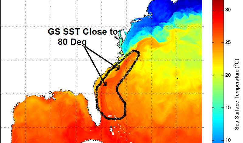
temps are 80 east of florida then 76 NE upward to about 100 miles south of northcarolina
and i see a spot off sc as well, but i don't think this is where main system will set up indications are further NE offshore outer banks (my guess is offshore SC spin will rotate ne and congeal with shortwave energy droppiing se from NE and form offshore hatteras unless it is a double barrell deal
then drifting east and consolidating/stacking today as it intensifys and then sliding southward tonite and then from there it is either
a/ slowly WSW into the coast which alot of models are hinting at wednesday
b/ or other's go with climo and wait for models to "correct" themselves and call for it going more sw off of jax by hundred and fifty miles as a weakened system wednesday an then out 2 c
c/ i dunno what i am talking about :p
hatteras bouy 150 miles east 34.5 72.6 29.92 and falling
Last edited by cpdaman on Sun May 06, 2007 9:06 am, edited 1 time in total.
0 likes
-
Tampa Bay Hurricane
- Category 5
- Posts: 5597
- Age: 38
- Joined: Fri Jul 22, 2005 7:54 pm
- Location: St. Petersburg, FL
-
Tampa Bay Hurricane
- Category 5
- Posts: 5597
- Age: 38
- Joined: Fri Jul 22, 2005 7:54 pm
- Location: St. Petersburg, FL
The Low Pressure and it's forecast through Wednesday is mentioned here.
The forecast path is indicated: Moving SLOWLY WESTWARD Monday thru wednesday
The forecast path is indicated: Moving SLOWLY WESTWARD Monday thru wednesday
URGENT - WEATHER MESSAGE
NATIONAL WEATHER SERVICE JACKSONVILLE FL
335 AM EDT SUN MAY 6 2007
FLZ024-025-032-033-037-038-GAZ153-154-165-166-061945-
/O.NEW.KJAX.LW.Y.0014.070506T2000Z-070509T0000Z/
NASSAU-DUVAL-CLAY-ST JOHNS-PUTNAM-FLAGLER-INLAND GLYNN-
COASTAL GLYNN-INLAND CAMDEN-COASTAL CAMDEN-
INCLUDING THE CITIES OF...FERNANDINA BEACH...JACKSONVILLE...
GREEN COVE SPRINGS...ST AUGUSTINE...PALATKA...PALM COAST...
BRUNSWICK...WOODBINE...ST MARYS
335 AM EDT SUN MAY 6 2007
...LAKE WIND ADVISORY IN EFFECT FROM 4 PM THIS AFTERNOON TO 8 PM
EDT TUESDAY...
THE NATIONAL WEATHER SERVICE IN JACKSONVILLE HAS ISSUED A LAKE
WIND ADVISORY...WHICH IS IN EFFECT FROM 4 PM THIS AFTERNOON TO
8 PM EDT TUESDAY.
A RAPIDLY DEEPENING LOW PRESSURE CENTER OFF THE NORTH CAROLINA
COAST THIS MORNING WILL DRIFT SOUTHWEST THROUGH TONIGHT AND THEN
WILL MOVE SLOWLY WESTWARD ON MONDAY THROUGH WEDNESDAY. AS IT
APPROACHES THE REGION WINDS WILL INCREASE OVER THE COASTAL
COUNTIES AS WELL AS CLAY AND PUTNAM COUNTIES TODAY. AT THIS
TIME...THE STRONGEST WINDS ARE EXPECTED OVER THE IMMEDIATE
BEACHES...THE INTRACOASTAL WATERWAY...AND ST JOHNS RIVER.
A LAKE WIND ADVISORY IS ISSUED WHEN SUSTAINED WINDS OF 20 TO
25 MPH OR GUSTS OF 30 TO 39 MPH ARE EXPECTED. SMALL BOATS WILL BE
ESPECIALLY PRONE TO CAPSIZING. BOATERS IN THE ADVISORY AREA
SHOULD AVOID OPEN WATER AND STAY CLOSE TO SHORE IN WIND PROTECTED
INLETS. HIGH PROFILE VEHICLES SHOULD USE EXTRA CAUTION WHEN
TRAVELING AS WELL.
$$
SANDRIK
0 likes
mods can correct me if i am wrong
but the hurricane force wind warning off NC/SC coasts is for the winds in the gulf stream that are supposed to be 65 to up to70 knots late today and thru tomorrow morning which is the squeezing of the pressure gradient from the monster high nosing down the east coast and the developing NOR'easter type low today off N. carolina not in reference to a tropical system which seems like this could turn into hybrid/subtropical storm by tuesday when winds are forecast to be ligher i.e 45 knots in the offshore water forecasts
1030 marine foreast update holds the same warnings and has sees up as high as 34 feet (wow) in the gulf stream off NC/SC tomorrow
Last edited by cpdaman on Sun May 06, 2007 9:24 am, edited 1 time in total.
0 likes
-
Opal storm


Who is online
Users browsing this forum: kevin, WaveBreaking and 223 guests