
2021 Global Model Runs Discussion (Out thru day 16)
Moderator: S2k Moderators
Forum rules

The posts in this forum are NOT official forecasts and should not be used as such. They are just the opinion of the poster and may or may not be backed by sound meteorological data. They are NOT endorsed by any professional institution or STORM2K. For official information, please refer to products from the National Hurricane Center and National Weather Service.
-
Clearcloudz

- Category 2

- Posts: 540
- Joined: Sun Jun 10, 2018 1:46 pm
- Location: Rosenberg TX
Re: 2021 Global Model Runs Discussion (Out thru day 16)
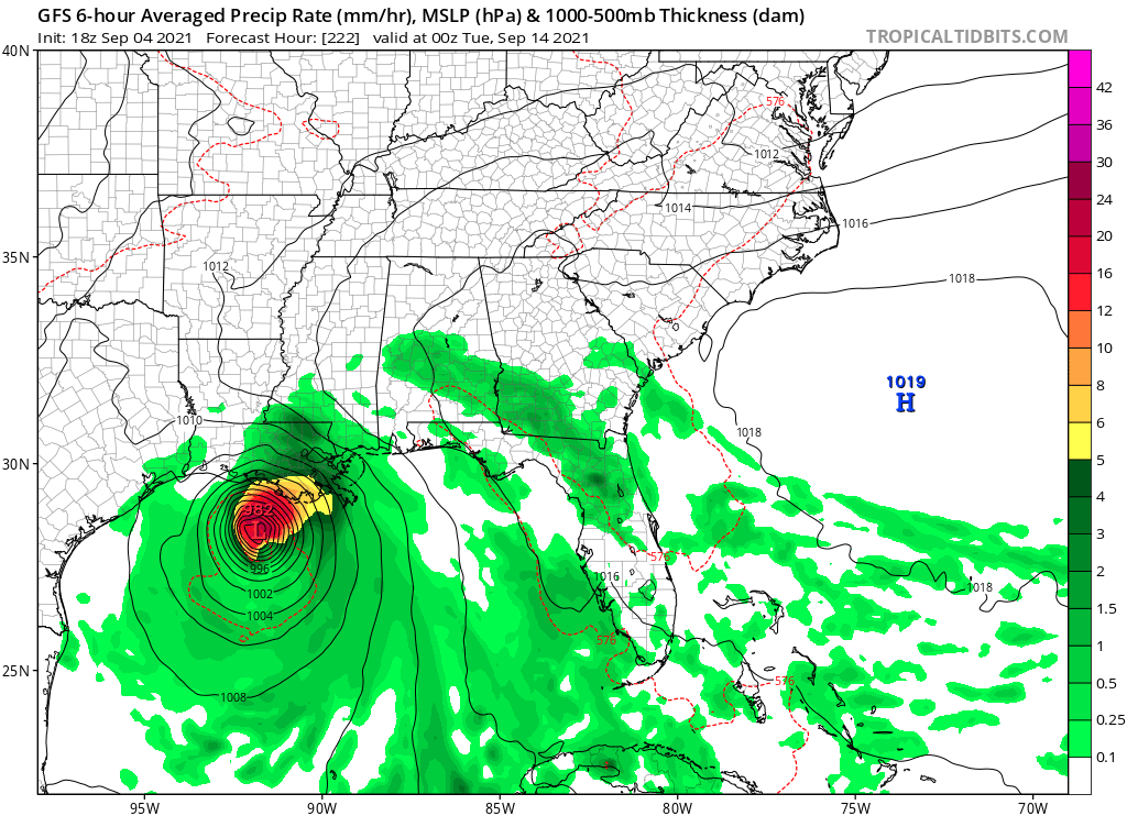
18Z GFS  All attention on whats coming in behind 91L
1 likes
-
Category5Kaiju

- Category 5

- Posts: 4335
- Joined: Thu Dec 24, 2020 12:45 pm
- Location: Seattle during the summer, Phoenix during the winter
Re: 2021 Global Model Runs Discussion (Out thru day 16)
And it looks to be headed right toward Ida-devastated Louisiana. I mean, seriously Mother Nature? Why do you hate Louisiana so much?
1 likes
Unless explicitly stated, all information in my posts is based on my own opinions and observations. Tropical storms and hurricanes can be extremely dangerous. Refer to an accredited weather research agency or meteorologist if you need to make serious decisions regarding an approaching storm.
-
AlphaToOmega
- Category 5
- Posts: 1448
- Joined: Sat Jun 26, 2021 10:51 am
- Location: Somewhere in Massachusetts
Re: 2021 Global Model Runs Discussion (Out thru day 16)
All we know from these GFS runs is that conditions are favorable in the W Carribean next week where it goes from there who knows.
1 likes
-
Clearcloudz
- Category 2
- Posts: 540
- Joined: Sun Jun 10, 2018 1:46 pm
- Location: Rosenberg TX
Re: 2021 Global Model Runs Discussion (Out thru day 16)
18Z GFS shows entire state of Louisiana getting slammed.


0 likes
-
Clearcloudz
- Category 2
- Posts: 540
- Joined: Sun Jun 10, 2018 1:46 pm
- Location: Rosenberg TX
Re: 2021 Global Model Runs Discussion (Out thru day 16)
18 GEFS showing a increase in ensemble support compared to 12Z run. Future runs will be interesting for sure. GEFS is outperforming other models.

0 likes
-
SouthFLTropics

- Category 5
- Posts: 4258
- Age: 50
- Joined: Thu Aug 14, 2003 8:04 am
- Location: Port St. Lucie, Florida
Re: 2021 Global Model Runs Discussion (Out thru day 16)
What is it with the Western Caribbean and GOM spinning up so many storms recently? We’ve been lucky here in South Florida this year but if this pattern of development continues into October I’m concerned that the we’re surely going to get smacked at some point.
Sent from my iPhone using Tapatalk
Sent from my iPhone using Tapatalk
2 likes
Fourth Generation Florida Native
Personal Storm History: David 79, Andrew 92, Erin 95, Floyd 99, Irene 99, Frances 04, Jeanne 04, Wilma 05, Matthew 16, Irma 17, Ian 22, Nicole 22, Milton 24
Personal Storm History: David 79, Andrew 92, Erin 95, Floyd 99, Irene 99, Frances 04, Jeanne 04, Wilma 05, Matthew 16, Irma 17, Ian 22, Nicole 22, Milton 24
-
cheezyWXguy

- Category 5
- Posts: 6282
- Joined: Mon Feb 13, 2006 12:29 am
- Location: Dallas, TX
Re: 2021 Global Model Runs Discussion (Out thru day 16)
To those of you worried about Louisiana, if it makes you feel better, I am not convinced that track makes sense. The 18z gfs plows a strengthening hurricane straight into the middle of a 500mb ridge without any influence of a trough. Seems fishy to me.
3 likes
Re: 2021 Global Model Runs Discussion (Out thru day 16)
cheezyWXguy wrote:To those of you worried about Louisiana, if it makes you feel better, I am not convinced that track makes sense. The 18z gfs plows a strengthening hurricane straight into the middle of a 500mb ridge without any influence of a trough. Seems fishy to me.
I saw that too would be more of threat to Texas if the ridge is set up like that.
1 likes


Re: 2021 Global Model Runs Discussion (Out thru day 16)
cheezyWXguy wrote:To those of you worried about Louisiana, if it makes you feel better, I am not convinced that track makes sense. The 18z gfs plows a strengthening hurricane straight into the middle of a 500mb ridge without any influence of a trough. Seems fishy to me.
What it looks like is that little storm finds a gap and the ridge builds back over top with a pretty strong cut off or at least a deep trough down in the Rockies moving across. Might not pull it up as depicted, but you can kind of see what it’s frying to show.
2 likes
-
cheezyWXguy
- Category 5
- Posts: 6282
- Joined: Mon Feb 13, 2006 12:29 am
- Location: Dallas, TX
Re: 2021 Global Model Runs Discussion (Out thru day 16)
Steve wrote:cheezyWXguy wrote:To those of you worried about Louisiana, if it makes you feel better, I am not convinced that track makes sense. The 18z gfs plows a strengthening hurricane straight into the middle of a 500mb ridge without any influence of a trough. Seems fishy to me.
What it looks like is that little storm finds a gap and the ridge builds back over top with a pretty strong cut off or at least a deep trough down in the Rockies moving across. Might not pull it up as depicted, but you can kind of see what it’s frying to show.
Yeah I guess I can see it more at the surface than I can at 500mb. This looks like one of those cases where the stronger it is, the more likely the storm is to shift west. If that set up actually plays out, the storm is going to be stronger than 982mb, which makes me think it’ll be more of a Texas threat or even far north Mexico, rather than something east of say, lake Charles.
Also of note, the 18z run is the strongest signal I’ve seen on the gefs yet. Obviously it’s still quite diffuse though.
1 likes
Re: 2021 Global Model Runs Discussion (Out thru day 16)
If conditions are as favorable as the GFS has been suggesting in recent runs I doubt this only gets down to 982 MB. I hope I am wrong but I think all bets are off when it comes to intensity with a TC in the gulf in early September.
0 likes


Re: 2021 Global Model Runs Discussion (Out thru day 16)
Normally in Sept tracks are to upper Gulf coast and Fl panhandle. But thats just climo. Concerned this far out that it could be a further east track than what the 18s GFS is depicting.
1 likes
Re: 2021 Global Model Runs Discussion (Out thru day 16)
MetroMike wrote:Normally in Sept tracks are to upper Gulf coast and Fl panhandle. But thats just climo. Concerned this far out that it could be a further east track than what the 18s GFS is depicting.
Really depends if there is trough to pull any potential TC too the NE. Usually in the 1st half of September we can still have strong ridges that can keep Texas in play to get hit by hurricanes. It isn't until about September 25th when people like me in Texas don't really have to worry about hurricanes.
0 likes

Re: 2021 Global Model Runs Discussion (Out thru day 16)
GFS is showing the mid-Sept GOM TC coming out of a broad surface low currently stretched across the Columbia / Venezuela shore.
Trades are out of the NE creating LL convergence with land interaction.
Appears to then phase with a weak wave, lagging 500mb vort, and strong anticyclone.
Will move into the west Carib and begin to spin up in 138 hrs drawing strong TPW air from the EPAC and high CAPE to its east.
Complicated but looks viable.
2 likes
-
jasons2k

- Storm2k Executive

- Posts: 8290
- Age: 52
- Joined: Wed Jul 06, 2005 12:32 pm
- Location: The Woodlands, TX
Re: 2021 Global Model Runs Discussion (Out thru day 16)
Steve wrote:cheezyWXguy wrote:To those of you worried about Louisiana, if it makes you feel better, I am not convinced that track makes sense. The 18z gfs plows a strengthening hurricane straight into the middle of a 500mb ridge without any influence of a trough. Seems fishy to me.
What it looks like is that little storm finds a gap and the ridge builds back over top with a pretty strong cut off or at least a deep trough down in the Rockies moving across. Might not pull it up as depicted, but you can kind of see what it’s frying to show.
Will come down to timing. Hehe so what’s new?
This one is still unclear but after today’s trends I am thinking more towards LA versus Texas. Not that I want it here but geez I feel for your wonderful state.
1 likes
Re: 2021 Global Model Runs Discussion (Out thru day 16)
Now looks like this will be an ARWB one-two punch.
First AWRB is when this is in the west Carib allowing the TC to develop.
RW then moves out allowing weak steering. TC could go across the Yucatan or thru the Yucatan Channel.
2nd RW then moves in with trof over AZ.
That RW sets up the second ARWB when the TC gets in the GOM allowing for further intensification.
The latest GFS run has a low forming south of Tec Isth at the time the TC is in the mid GOM pinching off any inflow of TPW air from the EPAC.
If the low doesn't form, this could become very strong.
3 likes
Re: 2021 Global Model Runs Discussion (Out thru day 16)
The signal for genesis of an AEW in mid-Sep along with mainly W movement is still there on the 12Z EPS. However, regarding the strong AEW still progged by several models to come off Africa ~9/11, the trend is for a sharp recurve due to a weakness in the far E Atlantic, which has gotten more prominent on the Euro suites as the high is further west in the mid Atlantic Ocean.
So, it appears that there will probably be a strong AEW moving off 9/11 probably followed by a sharp recurve followed by at least one more AEW moving off near 9/14-5 followed by that one being the one that likely moves mainly westward. We’ll see though as that’s still 10 days out and much can change just like the changes with the 9/11 wave.
So, it appears that there will probably be a strong AEW moving off 9/11 probably followed by a sharp recurve followed by at least one more AEW moving off near 9/14-5 followed by that one being the one that likely moves mainly westward. We’ll see though as that’s still 10 days out and much can change just like the changes with the 9/11 wave.
1 likes
Personal Forecast Disclaimer:
The posts in this forum are NOT official forecasts and should not be used as such. They are just the opinion of the poster and may or may not be backed by sound meteorological data. They are NOT endorsed by any professional institution or storm2k.org. For official information, please refer to the NHC and NWS products.
The posts in this forum are NOT official forecasts and should not be used as such. They are just the opinion of the poster and may or may not be backed by sound meteorological data. They are NOT endorsed by any professional institution or storm2k.org. For official information, please refer to the NHC and NWS products.
Re: 2021 Global Model Runs Discussion (Out thru day 16)
jasons2k wrote:Steve wrote:cheezyWXguy wrote:To those of you worried about Louisiana, if it makes you feel better, I am not convinced that track makes sense. The 18z gfs plows a strengthening hurricane straight into the middle of a 500mb ridge without any influence of a trough. Seems fishy to me.
What it looks like is that little storm finds a gap and the ridge builds back over top with a pretty strong cut off or at least a deep trough down in the Rockies moving across. Might not pull it up as depicted, but you can kind of see what it’s frying to show.
Will come down to timing. Hehe so what’s new?
This one is still unclear but after today’s trends I am thinking more towards LA versus Texas. Not that I want it here but geez I feel for your wonderful state.
If ever in doubt on where a Hurricane will hit it is a never bad idea to guess Louisiana. I think it is too early to know much about where this could go as it today is really the 1st day the GFS has consistently been showing a TC impacting the gulf states. Last 3 GFS runs 06z Bolivar Peninsula landfall, 12Z Matagorda Bay landfall, and 18Z Central LA landfall too early to have a trend in modeling.
2 likes

Re: 2021 Global Model Runs Discussion (Out thru day 16)
IcyTundra wrote:jasons2k wrote:Steve wrote:
What it looks like is that little storm finds a gap and the ridge builds back over top with a pretty strong cut off or at least a deep trough down in the Rockies moving across. Might not pull it up as depicted, but you can kind of see what it’s frying to show.
Will come down to timing. Hehe so what’s new?
This one is still unclear but after today’s trends I am thinking more towards LA versus Texas. Not that I want it here but geez I feel for your wonderful state.
If ever in doubt on where a Hurricane will hit it is a never bad idea to guess Louisiana. I think it is too early to know much about where this could go as it today is really the 1st day the GFS has consistently been showing a TC impacting the gulf states. Last 3 GFS runs 06z Bolivar Peninsula landfall, 12Z Matagorda Bay landfall, and 18Z Central LA landfall too early to have a trend in modeling.
If the GEFS/EPS starts trending stronger on this then it will definitely have my attention.
0 likes
Who is online
Users browsing this forum: cycloneye, Kingarabian and 237 guests