2025 Global Model Runs Discussion (Out thru day 16)
Moderator: S2k Moderators
Forum rules

The posts in this forum are NOT official forecasts and should not be used as such. They are just the opinion of the poster and may or may not be backed by sound meteorological data. They are NOT endorsed by any professional institution or STORM2K. For official information, please refer to products from the National Hurricane Center and National Weather Service.
-
Cachondo23
- Tropical Storm

- Posts: 131
- Joined: Wed May 25, 2022 5:56 am
Re: 2025 Global Model Runs Discussion (Out thru day 16)
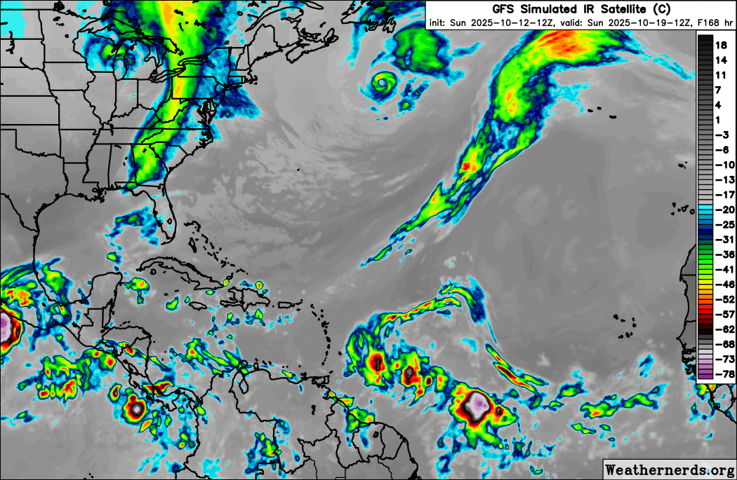
Very weird tracks from the GFS. Latest has it going west of Guadeloupe then completely north through Virgin Islands.
0 likes

Re: 2025 Global Model Runs Discussion (Out thru day 16)
Jr0d wrote:Still a good ensemble signal in the west Carib from the GFS and Canadian at the end of their runs. However the GFS and to a lesser extent the Canadian has consistently shown a signal there often all season long so I dont think its anything to worry about for now.
The wave the models show possibly developing and heading towards PR is something we may need to keep an eye on...interesting enough the ICON has been the southern outlier...it will be interesting to see what it does when its forecast range takes it it PR's longitude.
Along with Happy Hour Icon, the Happy Hour GFS, like the 12Z, 0Z, and 5 runs before, has this. It hits Virgin Islands with a cat 1 H 10/22-3.
Edit: I just looked at 12Z UKMET maps. Although the text already told me there was no TC from this, the H5 vorticity and precip maps are closer to a TCG than prior runs. If this trend continues, the often genesis shy UKMET may have an actual TCG from this within the next run or two.
0 likes
Personal Forecast Disclaimer:
The posts in this forum are NOT official forecasts and should not be used as such. They are just the opinion of the poster and may or may not be backed by sound meteorological data. They are NOT endorsed by any professional institution or storm2k.org. For official information, please refer to the NHC and NWS products.
The posts in this forum are NOT official forecasts and should not be used as such. They are just the opinion of the poster and may or may not be backed by sound meteorological data. They are NOT endorsed by any professional institution or storm2k.org. For official information, please refer to the NHC and NWS products.


Re: 2025 Global Model Runs Discussion (Out thru day 16)
Favorable background state means we are probably going to get a storm, without anything popping up in the EPAC anything in the Caribbean won’t have competition.
4 likes
Re: 2025 Global Model Runs Discussion (Out thru day 16)
LarryWx wrote:Jr0d wrote:Still a good ensemble signal in the west Carib from the GFS and Canadian at the end of their runs. However the GFS and to a lesser extent the Canadian has consistently shown a signal there often all season long so I dont think its anything to worry about for now.
The wave the models show possibly developing and heading towards PR is something we may need to keep an eye on...interesting enough the ICON has been the southern outlier...it will be interesting to see what it does when its forecast range takes it it PR's longitude.
Along with Happy Hour Icon, the Happy Hour GFS, like the 12Z, 0Z, and 5 runs before, has this. It hits Virgin Islands with a cat 1 H 10/22-3.
Edit: I just looked at 12Z UKMET maps. Although the text already told me there was no TC from this, the H5 vorticity and precip maps are closer to a TCG than prior runs. If this trend continues, the often genesis shy UKMET may have an actual TCG from this within the next run or two.
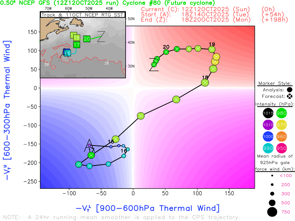
Sure enough, the 0Z UKMET has this as a TD going just N of due W at a rather brisk pace through the middle of the Lesser Antilles on Sunday (10/19): keep in mind that this is a top tier model that is sometimes genesis shy
NEW TROPICAL CYCLONE FORECAST TO DEVELOP AFTER 150 HOURS
FORECAST POSITION AT T+150 : 13.5N 57.7W
LEAD CENTRAL MAXIMUM WIND
VERIFYING TIME TIME POSITION PRESSURE (MB) SPEED (KNOTS)
-------------- ---- -------- ------------- -------------
1200UTC 19.10.2025 156 13.8N 59.5W 1010 32
0000UTC 20.10.2025 168 14.1N 62.8W 1009 34
FORECAST POSITION AT T+150 : 13.5N 57.7W
LEAD CENTRAL MAXIMUM WIND
VERIFYING TIME TIME POSITION PRESSURE (MB) SPEED (KNOTS)
-------------- ---- -------- ------------- -------------
1200UTC 19.10.2025 156 13.8N 59.5W 1010 32
0000UTC 20.10.2025 168 14.1N 62.8W 1009 34
Also, the Icon (0Z) has it yet again.
Last edited by LarryWx on Sun Oct 12, 2025 11:14 pm, edited 1 time in total.
3 likes
Personal Forecast Disclaimer:
The posts in this forum are NOT official forecasts and should not be used as such. They are just the opinion of the poster and may or may not be backed by sound meteorological data. They are NOT endorsed by any professional institution or storm2k.org. For official information, please refer to the NHC and NWS products.
The posts in this forum are NOT official forecasts and should not be used as such. They are just the opinion of the poster and may or may not be backed by sound meteorological data. They are NOT endorsed by any professional institution or storm2k.org. For official information, please refer to the NHC and NWS products.
Re: 2025 Global Model Runs Discussion (Out thru day 16)
LarryWx wrote:LarryWx wrote:Jr0d wrote:Still a good ensemble signal in the west Carib from the GFS and Canadian at the end of their runs. However the GFS and to a lesser extent the Canadian has consistently shown a signal there often all season long so I dont think its anything to worry about for now.
The wave the models show possibly developing and heading towards PR is something we may need to keep an eye on...interesting enough the ICON has been the southern outlier...it will be interesting to see what it does when its forecast range takes it it PR's longitude.
Along with Happy Hour Icon, the Happy Hour GFS, like the 12Z, 0Z, and 5 runs before, has this. It hits Virgin Islands with a cat 1 H 10/22-3.
Edit: I just looked at 12Z UKMET maps. Although the text already told me there was no TC from this, the H5 vorticity and precip maps are closer to a TCG than prior runs. If this trend continues, the often genesis shy UKMET may have an actual TCG from this within the next run or two.
Sure enough, the 0Z UKMET has this as a TD going just N of due W at a rather brisk pace through the middle of the Lesser Antilles on Sunday (10/19):NEW TROPICAL CYCLONE FORECAST TO DEVELOP AFTER 150 HOURS
FORECAST POSITION AT T+150 : 13.5N 57.7W
LEAD CENTRAL MAXIMUM WIND
VERIFYING TIME TIME POSITION PRESSURE (MB) SPEED (KNOTS)
-------------- ---- -------- ------------- -------------
1200UTC 19.10.2025 156 13.8N 59.5W 1010 32
0000UTC 20.10.2025 168 14.1N 62.8W 1009 34
Also, the Icon (0Z) has it yet again.
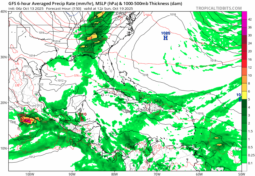
So the UK is following the route where it gets stronger in the western Caribbean and heads north northeast into either Cuba or Florida.
0 likes
Re: 2025 Global Model Runs Discussion (Out thru day 16)
Looks like we will either have a little to nothing, or a west carb monster on this gfs run. It could start heading straight north from its current position when I’m posting. Yep, north again
Last edited by Fancy1002 on Mon Oct 13, 2025 12:27 am, edited 1 time in total.
1 likes
Re: 2025 Global Model Runs Discussion (Out thru day 16)
Thanks, Fancy.
The 0Z CMC has a track that resembles none on record that have actually occurred in Oct or later with a TS very early (hour 90/Thu way east at 34W) that then beelines WNW to 68W just N of PR at 240! I’ll put this in the extremely unlikely track category (though not impossible) based mainly on many decades of tracks from the satellite era. This is like an August track! The further south and much later developing Icon, UKMET, and especially GFS are much more believable.
Euro is next.
1 likes
Personal Forecast Disclaimer:
The posts in this forum are NOT official forecasts and should not be used as such. They are just the opinion of the poster and may or may not be backed by sound meteorological data. They are NOT endorsed by any professional institution or storm2k.org. For official information, please refer to the NHC and NWS products.
The posts in this forum are NOT official forecasts and should not be used as such. They are just the opinion of the poster and may or may not be backed by sound meteorological data. They are NOT endorsed by any professional institution or storm2k.org. For official information, please refer to the NHC and NWS products.
Re: 2025 Global Model Runs Discussion (Out thru day 16)
LarryWx wrote:Thanks, Fancy.
The 0Z CMC has a track that resembles none on record that have actually occurred in Oct or later with a TS very early (hour 90/Thu way east at 34W) that then beelines WNW to 68W just N of PR at 240! I’ll put this in the extremely unlikely track category (though not impossible) based mainly on many decades of tracks from the satellite era. This is like an August track! The further south and much later developing Icon, UKMET, and especially GFS are much more believable.
Euro is next.
I would say it’s 50-50 on if the CMC model went out another 60 hours whether the storm would continue or immediately head north.
1 likes
Re: 2025 Global Model Runs Discussion (Out thru day 16)
LarryWx wrote:Thanks, Fancy.
The 0Z CMC has a track that resembles none on record that have actually occurred in Oct or later with a TS very early (hour 90/Thu way east at 34W) that then beelines WNW to 68W just N of PR at 240! I’ll put this in the extremely unlikely track category (though not impossible) based mainly on many decades of tracks from the satellite era. This is like an August track! The further south and much later developing Icon, UKMET, and especially GFS are much more believable.
Euro is next.
My guest with the euro is that it will be similar to the 12z run, but I’m not staying awake long enough to find out.
0 likes
Re: 2025 Global Model Runs Discussion (Out thru day 16)
I know it’s not much, but you can see future 98L at the bottom of the HWRF parent model.
Also, I’m not entirely sure if it’s the same way, I think it is when looking at the vort part of the model, but the euro AI model show partial development in the west edge of the Caribbean, heading north into the Gulf and onto Florida
Also, I’m not entirely sure if it’s the same way, I think it is when looking at the vort part of the model, but the euro AI model show partial development in the west edge of the Caribbean, heading north into the Gulf and onto Florida
0 likes
Re: 2025 Global Model Runs Discussion (Out thru day 16)
Fancy1002 wrote:I know it’s not much, but you can see future 98L at the bottom of the HWRF parent model.
Also, I’m not entirely sure if it’s the same way, I think it is when looking at the vort part of the model, but the euro AI model show partial development in the west edge of the Caribbean, heading north into the Gulf and onto Florida
1. It’s the same based on following the various upper vortices.
2. Based also on upper vortex, the 0Z Euro is close to a TD at the Lesser Antilles. But the sfc low itself is still weak then. However, soon after at 198 in E Caribbean pretty far S, a TD forms and moves WNW. This kind of resembles the UKMET though a little slower.
Edit: Then turns back almost due W and goes well S of Jamaica as a strengthening TS.
Edit: It then moves slowly W underneath a strengthening ridge in the direction of Honduras/Nicaragua at end of run at 947 mb. That general kind of track has occurred several times mid Oct and later in stark contrast to the CMC track. Details that far out are unimportant, regardless.
1 likes
Personal Forecast Disclaimer:
The posts in this forum are NOT official forecasts and should not be used as such. They are just the opinion of the poster and may or may not be backed by sound meteorological data. They are NOT endorsed by any professional institution or storm2k.org. For official information, please refer to the NHC and NWS products.
The posts in this forum are NOT official forecasts and should not be used as such. They are just the opinion of the poster and may or may not be backed by sound meteorological data. They are NOT endorsed by any professional institution or storm2k.org. For official information, please refer to the NHC and NWS products.
Re: 2025 Global Model Runs Discussion (Out thru day 16)
LarryWx wrote:Fancy1002 wrote:I know it’s not much, but you can see future 98L at the bottom of the HWRF parent model.
Also, I’m not entirely sure if it’s the same way, I think it is when looking at the vort part of the model, but the euro AI model show partial development in the west edge of the Caribbean, heading north into the Gulf and onto Florida
1. It’s the same based on following the various upper vortices.
2. Based also on upper vortex, the 0Z Euro is close to a TD at the Lesser Antilles. But the sfc low itself is still weak then. However, soon after at 198 in E Caribbean pretty far S, a TD forms and moves WNW. This kind of resembles the UKMET though a little slower.
Edit: Then turns back almost due W and goes well S of Jamaica as a strengthening TS.
Edit: It then moves slowly W underneath a strengthening ridge in the direction of Honduras/Nicaragua at end of run at 947 mb. That general kind of track has occurred several times mid Oct and later in stark contrast to the CMC track. Details that far out are unimportant, regardless.
Would you mind posting a picture of the ending of the run if you can, or send a link. Tropical tidbits is really slow at getting the euro in.
If the environment is how I think it is, it will likely be heading north to north west from that ending point then north east
1 likes
Re: 2025 Global Model Runs Discussion (Out thru day 16)
Fancy1002 wrote:LarryWx wrote:Fancy1002 wrote:I know it’s not much, but you can see future 98L at the bottom of the HWRF parent model.
Also, I’m not entirely sure if it’s the same way, I think it is when looking at the vort part of the model, but the euro AI model show partial development in the west edge of the Caribbean, heading north into the Gulf and onto Florida
1. It’s the same based on following the various upper vortices.
2. Based also on upper vortex, the 0Z Euro is close to a TD at the Lesser Antilles. But the sfc low itself is still weak then. However, soon after at 198 in E Caribbean pretty far S, a TD forms and moves WNW. This kind of resembles the UKMET though a little slower.
Edit: Then turns back almost due W and goes well S of Jamaica as a strengthening TS.
Edit: It then moves slowly W underneath a strengthening ridge in the direction of Honduras/Nicaragua at end of run at 947 mb. That general kind of track has occurred several times mid Oct and later in stark contrast to the CMC track. Details that far out are unimportant, regardless.
Would you mind posting a picture of the ending of the run if you can, or send a link. Tropical tidbits is really slow at getting the euro in.
If the environment is how I think it is, it will likely be heading north to north west from that ending point then north east
I can’t link it as it is paywalled. But I can tell you that H5 winds are clearly E to W underneath a strong (593 dm) H5 high covering entire Gulf and moving only slowly E. This is extremely speculative so far out but that setup tells me it, would hit Honduras/Nic border area within 48 hours similar to Mitch of 1998 on about the same date. Eventually though it could turn NW, N, and then NE if it survives land.
0 likes
Personal Forecast Disclaimer:
The posts in this forum are NOT official forecasts and should not be used as such. They are just the opinion of the poster and may or may not be backed by sound meteorological data. They are NOT endorsed by any professional institution or storm2k.org. For official information, please refer to the NHC and NWS products.
The posts in this forum are NOT official forecasts and should not be used as such. They are just the opinion of the poster and may or may not be backed by sound meteorological data. They are NOT endorsed by any professional institution or storm2k.org. For official information, please refer to the NHC and NWS products.
Re: 2025 Global Model Runs Discussion (Out thru day 16)
LarryWx wrote:Fancy1002 wrote:LarryWx wrote:
1. It’s the same based on following the various upper vortices.
2. Based also on upper vortex, the 0Z Euro is close to a TD at the Lesser Antilles. But the sfc low itself is still weak then. However, soon after at 198 in E Caribbean pretty far S, a TD forms and moves WNW. This kind of resembles the UKMET though a little slower.
Edit: Then turns back almost due W and goes well S of Jamaica as a strengthening TS.
Edit: It then moves slowly W underneath a strengthening ridge in the direction of Honduras/Nicaragua at end of run at 947 mb. That general kind of track has occurred several times mid Oct and later in stark contrast to the CMC track. Details that far out are unimportant, regardless.
Would you mind posting a picture of the ending of the run if you can, or send a link. Tropical tidbits is really slow at getting the euro in.
If the environment is how I think it is, it will likely be heading north to north west from that ending point then north east
I can’t link it as it is paywalled. But I can tell you that H5 winds are clearly E to W underneath a strong (593 dm) H5 high covering entire Gulf and moving only slowly E. This is extremely speculative so far out but that setup tells me it, would hit Honduras/Nic border area within 48 hours similar to Mitch of 1998. Eventually though it could turn NW, N, and then NE if it survives land.
The AI model is doing something similar interacts with Honduras and Nicaragua, before going north back over the water, then hitting the Yucatán, then heading towards Florida. Worst case scenario is this kind of storm gets into the western Caribbean and gets close to land, but not enough to cause it to weaken while it heads north north west towards the gap and off to Florida.
0 likes
-
cycloneye

- Admin

- Posts: 149259
- Age: 69
- Joined: Thu Oct 10, 2002 10:54 am
- Location: San Juan, Puerto Rico
Re: 2025 Global Model Runs Discussion (Out thru day 16)
Here is the complete run from 00z Euro.

3 likes
Visit the Caribbean-Central America Weather Thread where you can find at first post web cams,radars
and observations from Caribbean basin members Click Here
and observations from Caribbean basin members Click Here
-
Cachondo23
- Tropical Storm
- Posts: 131
- Joined: Wed May 25, 2022 5:56 am
Re: 2025 Global Model Runs Discussion (Out thru day 16)
Both GFS and Euro in the same area near Jamaica. Getting interesting…
1 likes


Re: 2025 Global Model Runs Discussion (Out thru day 16)
Looks like strong model support for major development of this system from Euro, GFS, ICON, CMC, and UKMET. Southern track into Carribean from Euro, 06z GFS, and UKMET. Still a long ways out though.
3 likes

Re: 2025 Global Model Runs Discussion (Out thru day 16)
ronjon wrote:Looks like strong model support for major development of this system from Euro, GFS, ICON, CMC, and UKMET. Southern track into Carribean from Euro, 06z GFS, and UKMET. Still a long ways out though.
Still a long way out indeed but when was the last time we actually saw this strong of a signal from all primary model camps - this far out? I'm thinking at least a season ago, if not longer. There will be plenty of windshield-wiper affect over the days to come.
1 likes
Andy D
(For official information, please refer to the NHC and NWS products.)
(For official information, please refer to the NHC and NWS products.)

Re: 2025 Global Model Runs Discussion (Out thru day 16)
6z GFS back to showing a 940 mb WCar MH, similar to 0z Euro but with different track:
0 likes
TC naming lists: retirements and intensity
Most aggressive Advisory #1's in North Atlantic (cr. kevin for starting the list)
Most aggressive Advisory #1's in North Atlantic (cr. kevin for starting the list)
Who is online
Users browsing this forum: No registered users and 104 guests