2019 Tropics: Global Model Runs Discussion (Out to day 16)
Moderator: S2k Moderators
Forum rules

The posts in this forum are NOT official forecasts and should not be used as such. They are just the opinion of the poster and may or may not be backed by sound meteorological data. They are NOT endorsed by any professional institution or STORM2K. For official information, please refer to products from the National Hurricane Center and National Weather Service.
-
Hypercane_Kyle

- Category 5

- Posts: 3465
- Joined: Sat Mar 07, 2015 7:58 pm
- Location: Cape Canaveral, FL
Re: 2019 Tropics: Global Model Runs Discussion (Out to day 16)
Yea, 120 hours is hardly fantasy land (I reserve that for 168 hours and beyond personally). GFS has been incredibly consistent with this solution, so either this is going to be a massive win for the GFS or a massive loss.
1 likes
My posts are my own personal opinion, defer to the National Hurricane Center (NHC) and other NOAA products for decision making during hurricane season.
-
gatorcane

- S2K Supporter

- Posts: 23708
- Age: 48
- Joined: Sun Mar 13, 2005 3:54 pm
- Location: Boca Raton, FL
Re: 2019 Tropics: Global Model Runs Discussion (Out to day 16)
The GFS run ends with another SW Caribbean storm. It would not surprise me if we get one later this month.
3 likes
-
SFLcane

- S2K Supporter
- Posts: 10281
- Age: 48
- Joined: Sat Jun 05, 2010 1:44 pm
- Location: Lake Worth Florida
Re: 2019 Tropics: Global Model Runs Discussion (Out to day 16)
gatorcane wrote:The GFS run ends with another SW Caribbean storm. It would not surprise me if we get one later this month.
https://i.postimg.cc/506QBPwN/gfs-mslp-pcpn-watl-64.png
Extreme fantasy but EPS is also showing something around the same time frame.
0 likes
-
Hurricaneman

- Category 5
- Posts: 7404
- Age: 45
- Joined: Tue Aug 31, 2004 3:24 pm
- Location: central florida
Re: 2019 Tropics: Global Model Runs Discussion (Out to day 16)
SFLcane wrote:gatorcane wrote:The GFS run ends with another SW Caribbean storm. It would not surprise me if we get one later this month.
https://i.postimg.cc/506QBPwN/gfs-mslp-pcpn-watl-64.png
Extreme fantasy but EPS is also showing something around the same time frame.
It’s probably not a phantom because It can be traced back to the wave that just came off of Africa
0 likes

Re: 2019 Tropics: Global Model Runs Discussion (Out to day 16)
T minus 90 hr's - https://imgur.com/FxMR6rE
0 likes
Andy D
(For official information, please refer to the NHC and NWS products.)
(For official information, please refer to the NHC and NWS products.)

Re: 2019 Tropics: Global Model Runs Discussion (Out to day 16)
Looking increasingly likely for tropical cyclone development in the western Caribbean somewhere south of Jamaica with GFS, ICON, and CMC all persistently showing a cyclone spinning up in 4-5 days. Ridging at 500 mb looks solid to steer perhaps a major hurricane into Belieze in about a week.
2 likes

Re: 2019 Tropics: Global Model Runs Discussion (Out to day 16)
Looks like this will initiate out of the Gyre from the E PAC when the surface winds south of Panama shift to the west.
1 likes
Re: 2019 Tropics: Global Model Runs Discussion (Out to day 16)
GCANE wrote:Euro spins it up in the EPAC
Euro ensembles also cluster in the W Carib with one making landfall in Belize at 951mb
0 likes

Re: 2019 Tropics: Global Model Runs Discussion (Out to day 16)
I know it’s 2019 and we set heat records through the first week of October, but you have to wonder if the ridge the models keep showing really holds by middle October. Climo just doesn’t favor a continued westward track down there. Then again, 2019 has thumbed it’s nose at climo so far.
1 likes

Re: 2019 Tropics: Global Model Runs Discussion (Out to day 16)
Just unbelievable continuing differences between the GFS and operational Euro runs. Not until the Euro joins the rest of the models will the NHC start highlighting the south central Caribbean for possible tropical development. The trend by the Euro ensembles is of more members showing development showing development over the Caribbean.
1 likes
-
tolakram
- Admin

- Posts: 20176
- Age: 62
- Joined: Sun Aug 27, 2006 8:23 pm
- Location: Florence, KY (name is Mark)
Re: 2019 Tropics: Global Model Runs Discussion (Out to day 16)
NDG wrote:Just unbelievable continuing differences between the GFS and operational Euro runs. Not until the Euro joins the rest of the models will the NHC start highlighting the south central Caribbean for possible tropical development. The trend by the Euro ensembles is of more members showing development showing development over the Caribbean.
I don't see that much of a difference. The GFS develops the wave, the euro also shows it but develops a storm in the EPAC.
0 likes
M a r k
- - - - -
Join us in chat: Storm2K Chatroom Invite. Android and IOS apps also available.
The posts in this forum are NOT official forecasts and should not be used as such. Posts are NOT endorsed by any professional institution or STORM2K.org. For official information and forecasts, please refer to NHC and NWS products.
Re: 2019 Tropics: Global Model Runs Discussion (Out to day 16)
tolakram wrote:NDG wrote:Just unbelievable continuing differences between the GFS and operational Euro runs. Not until the Euro joins the rest of the models will the NHC start highlighting the south central Caribbean for possible tropical development. The trend by the Euro ensembles is of more members showing development showing development over the Caribbean.
I don't see that much of a difference. The GFS develops the wave, the euro also shows it but develops a storm in the EPAC.
If you look closely the Operational Euro develops a TW further west than what the GFS and other models show developing.
1 likes
-
SconnieCane
- Category 5
- Posts: 1013
- Joined: Thu Aug 02, 2018 5:29 pm
- Location: Madison, WI
Re: 2019 Tropics: Global Model Runs Discussion (Out to day 16)
2 likes

Re: 2019 Tropics: Global Model Runs Discussion (Out to day 16)
Does the convection that is developing in the south central Caribbean has anything to do with what the models have been hinting?
0 likes
-
cycloneye

- Admin
- Posts: 149223
- Age: 69
- Joined: Thu Oct 10, 2002 10:54 am
- Location: San Juan, Puerto Rico
Re: 2019 Tropics: Global Model Runs Discussion (Out to day 16)
There is a thread for the Caribbean area so the model runs can be posted there.
0 likes
Visit the Caribbean-Central America Weather Thread where you can find at first post web cams,radars
and observations from Caribbean basin members Click Here
and observations from Caribbean basin members Click Here
Re: 2019 Tropics: Global Model Runs Discussion (Out to day 16)
cycloneye wrote:There is a thread for the Caribbean area so the model runs can be posted there.
Thanks Cycloneye.
0 likes
-
Hurricaneman
- Category 5
- Posts: 7404
- Age: 45
- Joined: Tue Aug 31, 2004 3:24 pm
- Location: central florida
Re: 2019 Tropics: Global Model Runs Discussion (Out to day 16)
I’m thinking looking at the GFS there could be development in the western Caribbean around the 21st and does have a little support from the EPS, I think that’s where and when a potential threat pop up and not really from the current Caribbean system
0 likes
-
gatorcane
- S2K Supporter
- Posts: 23708
- Age: 48
- Joined: Sun Mar 13, 2005 3:54 pm
- Location: Boca Raton, FL
Re: 2019 Tropics: Global Model Runs Discussion (Out to day 16)
Hurricaneman wrote:I’m thinking looking at the GFS there could be development in the western Caribbean around the 21st and does have a little support from the EPS, I think that’s where and when a potential threat pop up and not really from the current Caribbean system
“Olga” would be a fitting name for such a late October system. The name is up there with some menacing and threatening female names of the past ending in “a” names - Irma, Wilma, and Imelda. We just need Melissa and Nestor to form somewhere else before then.
0 likes
-
Hurricaneman
- Category 5
- Posts: 7404
- Age: 45
- Joined: Tue Aug 31, 2004 3:24 pm
- Location: central florida
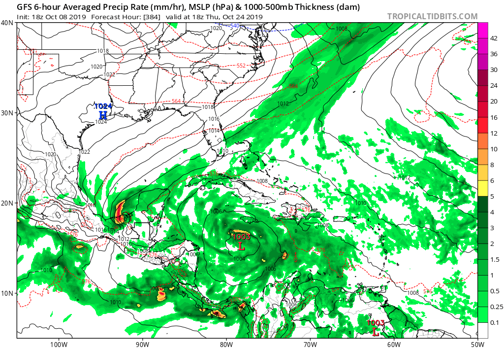
Re: 2019 Tropics: Global Model Runs Discussion (Out to day 16)
The 0zGFS has a system form around the 24th, the GFS ensembles seemed to be somewhat enthusiastic too, I’m not too sure how enthusiastic the EPS is though
0 likes
Who is online
Users browsing this forum: No registered users and 58 guests