Area of disturbed weather in the Caribbean
Moderator: S2k Moderators
Forum rules

The posts in this forum are NOT official forecasts and should not be used as such. They are just the opinion of the poster and may or may not be backed by sound meteorological data. They are NOT endorsed by any professional institution or STORM2K. For official information, please refer to products from the National Hurricane Center and National Weather Service.
-
brunota2003

- S2K Supporter

- Posts: 9476
- Age: 35
- Joined: Sat Jul 30, 2005 9:56 pm
- Location: Stanton, KY...formerly Havelock, NC
- Contact:
-
HURAKAN

- Professional-Met

- Posts: 46086
- Age: 38
- Joined: Thu May 20, 2004 4:34 pm
- Location: Key West, FL
- Contact:
Re: Caribbean development next week?
265
ABNT20 KNHC 070540
TWOAT
TROPICAL WEATHER OUTLOOK
NWS TPC/NATIONAL HURRICANE CENTER MIAMI FL
200 AM EDT SUN JUN 7 2009
FOR THE NORTH ATLANTIC...CARIBBEAN SEA AND THE GULF OF MEXICO...
CLOUDINESS AND SHOWERS OVER THE SOUTHWESTERN CARIBBEAN ARE
ASSOCIATED WITH A BROAD AREA OF LOW PRESSURE. SIGNIFICANT
DEVELOPMENT IS NOT LIKELY AT THIS TIME. HOWEVER...LOCALLY HEAVY
RAINS ARE EXPECTED TO SPREAD OVER PORTIONS OF CENTRAL AMERICA
DURING THE NEXT COUPLE OF DAYS. THERE IS A LOW CHANCE...LESS THAN
30 PERCENT...OF THIS SYSTEM BECOMING A TROPICAL CYCLONE DURING THE
NEXT 48 HOURS.
TROPICAL CYCLONE FORMATION IS NOT EXPECTED DURING THE NEXT 48 HOURS.
$$
FORECASTER AVILA
0 likes
-
cycloneye

- Admin

- Posts: 148738
- Age: 69
- Joined: Thu Oct 10, 2002 10:54 am
- Location: San Juan, Puerto Rico
Re: Caribbean development next week?
NHC not bullish about this at all as the words (At this time) are not in this new outlook.Another thing is that the most bullish model GFS,is less strong,while CMC,NOGAPS,UKMET continue with nada.And EURO doesnt do anything more than what it has been showing about this.
562
ABNT20 KNHC 071140
TWOAT
TROPICAL WEATHER OUTLOOK
NWS TPC/NATIONAL HURRICANE CENTER MIAMI FL
800 AM EDT SUN JUN 7 2009
FOR THE NORTH ATLANTIC...CARIBBEAN SEA AND THE GULF OF MEXICO...
CLOUDINESS AND SHOWERS OVER THE SOUTHWESTERN CARIBBEAN IN
ASSOCIATION WITH A BROAD AREA OF LOW PRESSURE HAVE DIMINISHED THIS
MORNING...AND SIGNIFICANT DEVELOPMENT IS NOT LIKELY. HOWEVER...
LOCALLY HEAVY RAINS ARE POSSIBLE OVER PORTIONS OF CENTRAL AMERICA
DURING THE NEXT COUPLE OF DAYS. THERE IS A LOW CHANCE... LESS THAN
30 PERCENT...OF THIS SYSTEM BECOMING A TROPICAL CYCLONE DURING THE
NEXT 48 HOURS.
TROPICAL CYCLONE FORMATION IS NOT EXPECTED DURING THE NEXT 48 HOURS.
$$
FORECASTER BRENNAN/BLAKE
http://www.storm2k.org/weather/hw3.php? ... hwvmetric=
0 likes

Re: Caribbean development next week?
Yeah, Luis, the models are definitely backing off on development with todays runs. However, it does look like some broad circulation has formed off the NE coast of NIC near 14.5N-83W this morning. Shear is still high though. Unlikey to see any development until that drops off. If it develops at all, I'd say it'll be much slower than I thought yesterday.
http://www.ssd.noaa.gov/goes/east/watl/loop-avn.html
http://www.ssd.noaa.gov/goes/east/watl/loop-avn.html
0 likes
-
CourierPR

- Category 5

- Posts: 1336
- Age: 71
- Joined: Tue Aug 31, 2004 7:53 pm
- Location: Pompano Beach, Florida
Re: Caribbean development next week?
If this disturbed area persists, I wouldn't rule out development mid to late week.
0 likes
-
wxman57

- Moderator-Pro Met

- Posts: 23122
- Age: 68
- Joined: Sat Jun 21, 2003 8:06 pm
- Location: Houston, TX (southwest)
Re: Caribbean development next week?
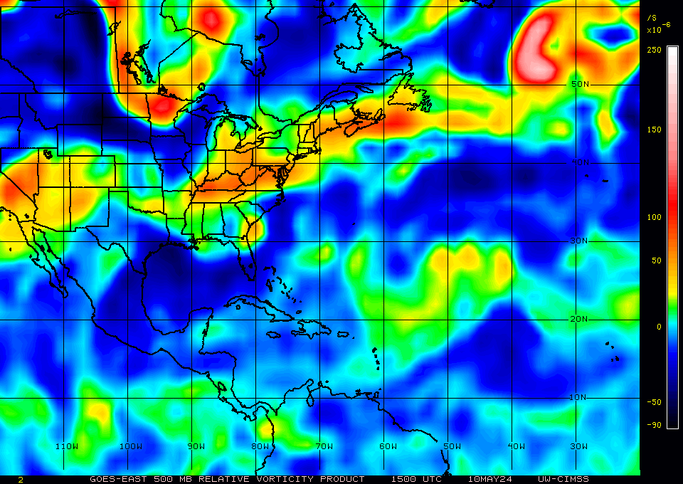
You can't use satellite imagery to identify a surface circulation in a system like this. The only way is with a surface plot. The current surface obs in the region show nothing near Nicaragua. Lowest pressures are near Panama (1011mb). Offshore NE Nicaragua pressures are 1012mb with straight ENE-E flow at 15 kts. So no low there.
As I look across the region, I see strong upper-level winds (shear) across the Gulf and western Caribbean today. Even the GFS, which develops some kind of low, indicates that the shear will persist through the 12th over much of the region, and continue over the NW Caribbean and Gulf through the 14th. 40-50kt winds at 200mb along a sharp trof axis would not be favorable for tropical development in the western Caribbean. After the 12th, the shear does let up in the north-central Caribbean, though.
We'll have to watch for passing tropical waves to interact with the upper-level trof over the next 5-10 days. Each time a wave passes, thunderstorms will increase for a while (like on Friday night). If a wave is passing as the upper trof is weakening (weakening shear) later this week or next, then something could get going. But as for chances of development in the next 48 hours, I agree with NHC - less than 30%. In fact, I'd say less than 1%. If the NHC really thought this area of disorganized storms had anywhere near a 30% chance of developing in the next 48 hours then it would be an invest.
Here's a 12Z plot:
0 likes
Re: Caribbean development next week?
Weak, but persistence never the less. Look for bursts for signs of getting going.
0 likes
Re: Caribbean development next week?
To add to the timing of development you mention, the NHC Tropical Outlooks aren't going that far out into the upcoming week in the current updates....as of this morning's update...
CLOUDINESS AND SHOWERS OVER THE SOUTHWESTERN CARIBBEAN IN
ASSOCIATION WITH A BROAD AREA OF LOW PRESSURE HAVE DIMINISHED THIS
MORNING...AND SIGNIFICANT DEVELOPMENT IS NOT LIKELY. HOWEVER...
LOCALLY HEAVY RAINS ARE POSSIBLE OVER PORTIONS OF CENTRAL AMERICA
DURING THE NEXT COUPLE OF DAYS. THERE IS A LOW CHANCE... LESS THAN
30 PERCENT...OF THIS SYSTEM BECOMING A TROPICAL CYCLONE DURING THE
NEXT 48 HOURS.
In theory, development could still have a somewhat higher chance (per at least a few models to varying degrees) beyond 48 hours.....in fact, i don't think any models are showing a tropical cyclone taking shape by tuesday morning....they are beyond that point in time.
It's semantics i know, but timing is everything, and i know i have been guilty of inferring low/no prospects of development for other systems after reading the Tropical Outlooks and overlooking they are 48-hour outlooks. Heck, even 96 hours before development, the 48-hour Outlook for the disturbance that would become Katrina would have also been 'low chances'...
CourierPR wrote:If this disturbed area persists, I wouldn't rule out development mid to late week.
0 likes
Re: Caribbean development next week?
Definitely a circulation in the VIS SAT off the NE coast of NIC - wxman57 confirms its not a low level so it must be mid-level. Convection on the increase today.
http://www.ssd.noaa.gov/goes/east/watl/loop-vis.html
http://www.ssd.noaa.gov/goes/east/watl/loop-vis.html
0 likes

Re: Caribbean development next week?
It looks like the low is right off the Nicaragua's coast.
http://metofis.rsmas.miami.edu/~dortt/s ... 1_loop.gif
http://metofis.rsmas.miami.edu/~dortt/s ... 1_loop.gif
0 likes

-
cycloneye
- Admin
- Posts: 148738
- Age: 69
- Joined: Thu Oct 10, 2002 10:54 am
- Location: San Juan, Puerto Rico
Re: Caribbean development next week?
528
ABNT20 KNHC 071738
TWOAT
TROPICAL WEATHER OUTLOOK
NWS TPC/NATIONAL HURRICANE CENTER MIAMI FL
200 PM EDT SUN JUN 7 2009
FOR THE NORTH ATLANTIC...CARIBBEAN SEA AND THE GULF OF MEXICO...
CLOUDINESS AND SHOWERS OVER THE SOUTHWESTERN CARIBBEAN SEA IN
ASSOCIATION WITH A BROAD AREA OF LOW PRESSURE HAVE CHANGED LITTLE
TODAY. UPPER-LEVEL WINDS ARE UNFAVORABLE FOR SIGNIFICANT
DEVELOPMENT OF THIS SYSTEM. HOWEVER...LOCALLY HEAVY RAINS ARE
POSSIBLE OVER PORTIONS OF CENTRAL AMERICA DURING THE NEXT COUPLE OF
DAYS. THERE IS A LOW CHANCE... LESS THAN 30 PERCENT...OF THIS
SYSTEM BECOMING A TROPICAL CYCLONE DURING THE NEXT 48 HOURS.
TROPICAL CYCLONE FORMATION IS NOT EXPECTED DURING THE NEXT 48 HOURS.
$$
FORECASTER BRENNAN/BLAKE
0 likes

Re: Caribbean development next week?
Shear lessening slightly according to this chart

Some vorticity at the mid levels
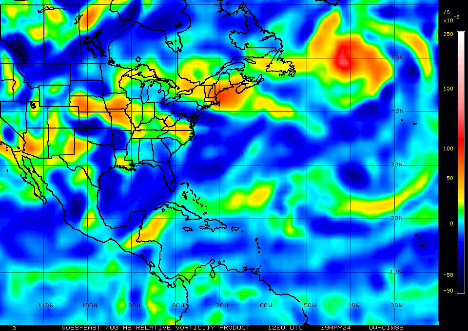
But very litlle near the surface as 57 showed in 12z plot

Some vorticity at the mid levels
But very litlle near the surface as 57 showed in 12z plot
0 likes


Re: Caribbean development next week?
NWS exept:
EXTENDED FORECAST...
THE LONG RANGE MODELS ARE STILL SHOWING A WEAK LOW IN THE
SOUTHWEST CARIBBEAN SEA TO DRIFT NORTHWARD LATE THIS WEEK INTO
THIS WEEKEND TOWARDS CUBA. THIS WILL ALLOW FOR THE PRESSURE
GRADIENT TO TIGHTEN A LITTLE BIT OVER SOUTH FLORIDA THIS WEEKEND...AND
ALLOW FOR SOME TROPICAL MOISTURE TO WORK INTO THE CWA FROM THE
CARIBBEAN SEA LATE THIS WEEKEND. SO HAVE KEPT THE WINDS BREEZY
ALONG THE EAST COAST AREAS THIS WEEKEND...AND INCREASE THE POPS TO
HIGH IN CHANCE OVER THE CWA LATE THIS WEEKEND.
WILL CONTINUE TO MONITOR THE LATEST LONG RANGE MODELS ON THE TRACK
AND STRENGTH OF THE LOW IN THE SOUTHWEST CARIBBEAN SEA THROUGH
THIS WEEK...AND ADJUST THE EXTENDED GRIDS IF NEED BE TO THE LATEST
LONG RANGE MODELS.
0 likes
12Z Nogaps like GFS has a closed low over or near S.Fl next weekend.
H+168
https://www.fnmoc.navy.mil/wxmap_cgi/cg ... rp&tau=168
H+168
https://www.fnmoc.navy.mil/wxmap_cgi/cg ... rp&tau=168
0 likes

Re: Caribbean development next week?
I think the only way for this to develop in the short term would be for a wedge of less shear to form in that area of the Caribbean. Long term, (as in late this week) most models seem to decrease the shear in the area, but this is of course, only a possibility.
0 likes
GFS 12Z H+150 similar to nogaps with closed low moving into Sfl next weekend.
http://www.nco.ncep.noaa.gov/pmb/nwprod ... n_150l.gif
http://www.nco.ncep.noaa.gov/pmb/nwprod ... n_150l.gif
0 likes
-
Derek Ortt

Who is online
Users browsing this forum: Blown Away and 71 guests