Disturbance In Eastern Caribbean.
Moderator: S2k Moderators
Forum rules

The posts in this forum are NOT official forecasts and should not be used as such. They are just the opinion of the poster and may or may not be backed by sound meteorological data. They are NOT endorsed by any professional institution or STORM2K. For official information, please refer to products from the National Hurricane Center and National Weather Service.
-
Blown Away

- S2K Supporter

- Posts: 10253
- Joined: Wed May 26, 2004 6:17 am


Re: Disturbance East Of Windward Islands.
Don't know why the image is so small but if you zoom in on this loop you can see it has decent structure this morning but little convection, as someone stated earlier.
http://rammb.cira.colostate.edu/ramsdis ... _floater_2
http://rammb.cira.colostate.edu/ramsdis ... _floater_2
0 likes
-
SEASON_CANCELED

- Category 3

- Posts: 887
- Joined: Mon Jul 06, 2009 5:17 am
- Location: 8 Bit Charlie Sheen
Re: Disturbance East Of Windward Islands.
nothing special right now. but what interests me is the potential when it enters the W. Carib. Perfect conditions if it survives
0 likes


-
fwbbreeze

- S2K Supporter
- Posts: 898
- Joined: Sun Mar 21, 2004 10:09 pm
- Location: Fort Walton Beach, FL
Re: Disturbance East Of Windward Islands.
I was looking at the area around 55W 15N and running loops both visible and infared. If you take the visible loops back through the day you can see a defined rotation in the lower clouds in the last few frames before nightfall. Recent infared loops show storms blowing up around the circulation. Probably not much there but it did catch my attention.
http://weather.msfc.nasa.gov/GOES/
http://weather.msfc.nasa.gov/GOES/
0 likes
-
SEASON_CANCELED
- Category 3
- Posts: 887
- Joined: Mon Jul 06, 2009 5:17 am
- Location: 8 Bit Charlie Sheen
Re: Disturbance East Of Windward Islands.
What I am thinking is several models are developing something 4 days out in west carib. and taking it up towards the Gulf but others see nothing. So I dont know what to make of it. It would have a long way to go. Alot of things would have to be in place.
0 likes

-
nashrobertsx
- Tropical Depression

- Posts: 85
- Joined: Fri Aug 15, 2008 3:55 pm
FROM NO AFD THIS MORNING....
THE SECOND TROPICAL WAVE MENTIONED IN HERE IS THIS ONE NOW OUT BY THE WINDWARD ISLANDS. ALL OF SUDDEN THINGS ARE PICKING UP LIKE CRAZY....
.LONG TERM...
THE FRONT STALLS EITHER VERY CLOSE TO THE COAST OR JUST OFFSHORE
BY THU NIGHT. THE UPPER TROUGH THAT DIGS SOUTH WITH THE COLD FRONT
THU WILL CUT OFF A WEAK UPPER LOW OVER THE NW GULF BY FRI. THIS
LOW WILL MEANDER OVER THE WESTERN GULF FOR A FEW DAYS AND
STRENGTHEN AS IT MOVES INTO SOUTH TX. THIS WILL CAUSE AN UPPER
ANTICYCLONE TO DEVELOP DOWN STREAM OVER THE EASTERN GULF THROUGH
THE WEEKEND WHILE THE SFC TROUGH REMAINS OVER THE SAME GENERAL
AREA. THEN WE INTRODUCE A STRONG TROPICAL WAVE INTO THE EASTERN
GULF BY SAT NIGHT OR SUN. THE NORTHERN END OF THIS WAVE WILL
SUBDUCT THE UPPER HIGH WHERE THERE WILL BE WEAK SHEAR AND A VERY
HOSPITABLE REGION FOR GROWTH. WE MAY SEE THIS AS SOON AS SUNDAY.
WOULD NORMALLY DISMISS THIS TYPE OF SOLUTION SO FAR OUT BUT THE
GLOBAL MODELS ARE ALL INITIALIZING VERY WELL AND SHOW THE MODERATE
TROPICAL WAVE FEATURE WITH A SLIGHT AMOUNT OF SYNOPTIC SCALE
ROTATION WELL ABOVE THE SFC ALONG 44W. THIS IS THE FEATURE THAT
EVENTUALLY MAKES ITS WAY INTO THE GULF BY THE END OF THE WEEK OR
MAYBE THE FIRST PART OF NEXT WEEK...NOT THE ONE THAT IS GARNISHING
ALL THE ATTENTION NEAR THE CAPE VERDE ISLANDS. TIMING REMAINS SKETCHY AT
BEST BUT IT IS SOMETHING TO WATCH AS WE MOVE CLOSER TO THE PEAK OF
THE SEASON. NOT VERY OFTEN THAT I WILL MAKE ANY MAJOR UPDATES TO
THE EXTENDED BUT HAVE OPTED TO BEGIN INCREASING RAIN CHANCES FOR
SUNDAY AND MONDAY EVER SO SLIGHTLY. IF THIS CURRENT MODEL TREND
CONTINUES THESE NUMBERS WILL LIKELY INCREASE FURTHER.
0 likes
-
AtlanticWind

- S2K Supporter
- Posts: 1898
- Age: 67
- Joined: Sun Aug 08, 2004 9:57 pm
- Location: Plantation,Fla
Re:
nashrobertsx wrote:FROM NO AFD THIS MORNING....
THE SECOND TROPICAL WAVE MENTIONED IN HERE IS THIS ONE NOW OUT BY THE WINDWARD ISLANDS. ALL OF SUDDEN THINGS ARE PICKING UP LIKE CRAZY....
.LONG TERM...
THE FRONT STALLS EITHER VERY CLOSE TO THE COAST OR JUST OFFSHORE
BY THU NIGHT. THE UPPER TROUGH THAT DIGS SOUTH WITH THE COLD FRONT
THU WILL CUT OFF A WEAK UPPER LOW OVER THE NW GULF BY FRI. THIS
LOW WILL MEANDER OVER THE WESTERN GULF FOR A FEW DAYS AND
STRENGTHEN AS IT MOVES INTO SOUTH TX. THIS WILL CAUSE AN UPPER
ANTICYCLONE TO DEVELOP DOWN STREAM OVER THE EASTERN GULF THROUGH
THE WEEKEND WHILE THE SFC TROUGH REMAINS OVER THE SAME GENERAL
AREA. THEN WE INTRODUCE A STRONG TROPICAL WAVE INTO THE EASTERN
GULF BY SAT NIGHT OR SUN. THE NORTHERN END OF THIS WAVE WILL
SUBDUCT THE UPPER HIGH WHERE THERE WILL BE WEAK SHEAR AND A VERY
HOSPITABLE REGION FOR GROWTH. WE MAY SEE THIS AS SOON AS SUNDAY.
WOULD NORMALLY DISMISS THIS TYPE OF SOLUTION SO FAR OUT BUT THE
GLOBAL MODELS ARE ALL INITIALIZING VERY WELL AND SHOW THE MODERATE
TROPICAL WAVE FEATURE WITH A SLIGHT AMOUNT OF SYNOPTIC SCALE
ROTATION WELL ABOVE THE SFC ALONG 44W. THIS IS THE FEATURE THAT
EVENTUALLY MAKES ITS WAY INTO THE GULF BY THE END OF THE WEEK OR
MAYBE THE FIRST PART OF NEXT WEEK...NOT THE ONE THAT IS GARNISHING
ALL THE ATTENTION NEAR THE CAPE VERDE ISLANDS. TIMING REMAINS SKETCHY AT
BEST BUT IT IS SOMETHING TO WATCH AS WE MOVE CLOSER TO THE PEAK OF
THE SEASON. NOT VERY OFTEN THAT I WILL MAKE ANY MAJOR UPDATES TO
THE EXTENDED BUT HAVE OPTED TO BEGIN INCREASING RAIN CHANCES FOR
SUNDAY AND MONDAY EVER SO SLIGHTLY. IF THIS CURRENT MODEL TREND
CONTINUES THESE NUMBERS WILL LIKELY INCREASE FURTHER.
They are talking about the wave at 44 west not the one by the windward islands
0 likes
-
fwbbreeze
- S2K Supporter
- Posts: 898
- Joined: Sun Mar 21, 2004 10:09 pm
- Location: Fort Walton Beach, FL
Re:
Aric Dunn wrote:I think we should be watching our old friend from earlier this week as this morning is showing signs of really coming back to life with a low level circulation and convection increasing slightly. its a low chance but still there..
Hey Aric,
A couple of posts above I mentioned that I saw the low level turning just as the daylight hours ran out yesterday. Something to watch for sure.
fwbbreeze
0 likes
-
Gustywind

- Category 5

- Posts: 12334
- Joined: Mon Sep 03, 2007 7:29 am
- Location: Baie-Mahault, GUADELOUPE
000
AXNT20 KNHC 101131
TWDAT
TROPICAL WEATHER DISCUSSION
NWS TPC/NATIONAL HURRICANE CENTER MIAMI FL
805 AM EDT MON AUG 10 2009
TROPICAL WEATHER DISCUSSION FOR NORTH AMERICA...CENTRAL
AMERICA...GULF OF MEXICO...CARIBBEAN SEA...NORTHERN SECTIONS
OF SOUTH AMERICA...AND ATLANTIC OCEAN TO THE AFRICAN COAST
FROM THE EQUATOR TO 32N. THE FOLLOWING INFORMATION IS BASED
ON SATELLITE IMAGERY...METEOROLOGICAL ANALYSIS...WEATHER
OBSERVATIONS...AND RADAR.
BASED ON 0600 UTC SURFACE ANALYSIS AND SATELLITE IMAGERY THROUGH
1115 UTC.
...TROPICAL WAVES...
TROPICAL WAVE IS FROM ALONG 57W/58W S OF 18N MOVING W 10-15 KT.
WAVE IS LOCATED ALONG A MOISTURE MAXIMUM OBSERVED IN THE TOTAL
PRECIPITABLE WATER IMAGERY AND LOW LEVEL CYCLONIC CIRCULATION IN
THE LOW CLOUDS ALONG THE WAVE AXIS NEAR 14N. CLUSTERS OF
SCATTERED MODERATE CONVECTION WITHIN 60 NM OF LINE FROM 15N55W
TO 14N60W.
$$
WALLACE
0 likes

Re: Disturbance East Of Windward Islands.
Convection now firing up on the east side of the well pronounced low level vorticity.
http://hadar.cira.colostate.edu/ramsdis/online/trop_ge_vis_float2_0.html
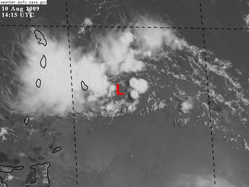
Barbados reporting northerly winds, the circulation center should pass through Barbados, lets see what kind of pressure it reports, already a couple of mb lower than 24 hrs ago.
Conditions at Aug 10, 2009 - 10:00 AM EDTAug 10, 2009 - 09:00 AM CDTAug 10, 2009 - 08:00 AM MDTAug 10, 2009 - 07:00 AM PDTAug 10, 2009 - 06:00 AM ADTAug 10, 2009 - 05:00 AM HDT
2009.08.10 1400 UTC
Wind from the N (350 degrees) at 6 MPH (5 KT)
Visibility 5 mile(s)
Sky conditions mostly cloudy
Weather Light rain showers
Cumulonimbus clouds observed
Temperature 78 F (26 C)
Dew Point 77 F (25 C)
Relative Humidity 94%
Pressure (altimeter) 29.94 in. Hg (1014 hPa)
ob TBPB 101400Z 35005KT 9000 -SHRA BKN010CB SCT016 BKN032 26/25 Q1014 NOSIG
http://hadar.cira.colostate.edu/ramsdis/online/trop_ge_vis_float2_0.html
Barbados reporting northerly winds, the circulation center should pass through Barbados, lets see what kind of pressure it reports, already a couple of mb lower than 24 hrs ago.
Conditions at Aug 10, 2009 - 10:00 AM EDTAug 10, 2009 - 09:00 AM CDTAug 10, 2009 - 08:00 AM MDTAug 10, 2009 - 07:00 AM PDTAug 10, 2009 - 06:00 AM ADTAug 10, 2009 - 05:00 AM HDT
2009.08.10 1400 UTC
Wind from the N (350 degrees) at 6 MPH (5 KT)
Visibility 5 mile(s)
Sky conditions mostly cloudy
Weather Light rain showers
Cumulonimbus clouds observed
Temperature 78 F (26 C)
Dew Point 77 F (25 C)
Relative Humidity 94%
Pressure (altimeter) 29.94 in. Hg (1014 hPa)
ob TBPB 101400Z 35005KT 9000 -SHRA BKN010CB SCT016 BKN032 26/25 Q1014 NOSIG
0 likes
Re: Disturbance East Of Windward Islands.
Looks like the fuming remnant of a wave worn down by dry conditions. The Caribbean should clobber it.
0 likes
-
Tropics Guy

- Tropical Storm

- Posts: 167
- Age: 63
- Joined: Tue Aug 31, 2004 8:12 pm
- Location: Hallandale beach & Vero beach, FL
Re: Disturbance East Of Windward Islands.
Convection starting to blow up, could be a weak area of low pressure developing., looks much better than yesterday.
0 likes
Winds from the north continue in Barbados, clear small circulation still seen on visible sat just to the east of the island.
Current Weather Conditions:
Grantley Adams, Barbados
(TBPB) 13-04N 059-29W 56M
--------------------------------------------------------------------------------
Conditions at Aug 10, 2009 - 11:40 AM EDTAug 10, 2009 - 10:40 AM CDTAug 10, 2009 - 09:40 AM MDTAug 10, 2009 - 08:40 AM PDTAug 10, 2009 - 07:40 AM ADTAug 10, 2009 - 06:40 AM HDT
2009.08.10 1540 UTC
Wind from the N (360 degrees) at 12 MPH (10 KT)
Visibility 1 mile(s)
Sky conditions mostly cloudy
Weather Rain with thunder
Cumulonimbus clouds observed
Temperature 77 F (25 C)
Dew Point 75 F (24 C)
Relative Humidity 94%
Pressure (altimeter) 29.94 in. Hg (1014 hPa)
ob TBPB 101540Z 36010KT 2500 TSRA BKN010CB SCT016 BKN032 25/24 Q1014 NOSIG
0 likes
Re: Disturbance East Of Windward Islands.
The slow westward movement is unusal for this area. It is probably a sign of the negative synoptic still being in place. The first cyclone will probably blow it out of place and open up the gates for development.
Barbados will probably record 1012 or so as my guess.
Barbados will probably record 1012 or so as my guess.
0 likes
Who is online
Users browsing this forum: South Texas Storms and 135 guests