This setup makes me wonder if we’ll see the system struggle to close off a low-level circulation. If it starts shooting NE before establishing the LLC, that could definitely occur. Sustained TS winds would still be possible due to forward motion.
Do we know approximately how fast the models show the system moving toward FL?
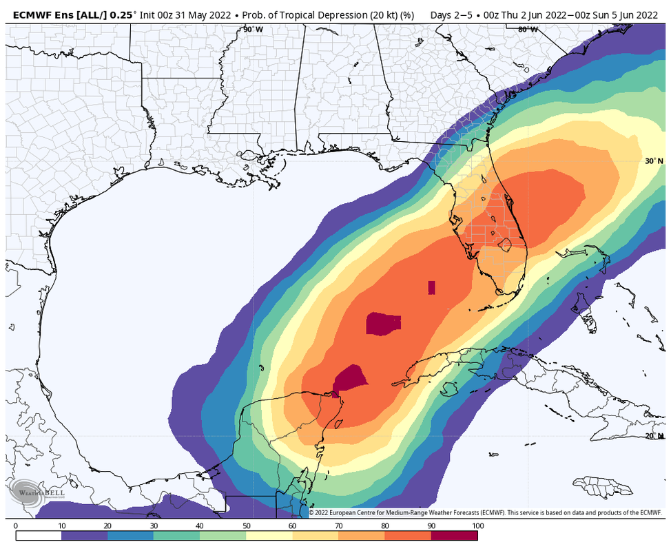
Near Yucatán / SE Gulf of Mexico development (Is Invest 91L)
Moderator: S2k Moderators
Forum rules

The posts in this forum are NOT official forecasts and should not be used as such. They are just the opinion of the poster and may or may not be backed by sound meteorological data. They are NOT endorsed by any professional institution or STORM2K. For official information, please refer to products from the National Hurricane Center and National Weather Service.
-
TallyTracker
- Category 2

- Posts: 787
- Joined: Thu Oct 11, 2018 2:46 pm
Re: Near Yucatán / NW Caribbean possible development?
0 likes
Fran '96, Georges '98, Gordon '00, Gabrielle '01, Charley '04, Frances '04, Jeanne '04, Barry '07, Fay '08, Debby '12, Matthew '16, Emily '17, Irma '17, Michael ‘18, Elsa ‘21, Fred ‘21, Mindy ‘21, Nicole ‘22, Idalia ‘23, Debby ‘24, Helene ‘24
-
skyline385

- Category 5

- Posts: 2728
- Age: 35
- Joined: Wed Aug 26, 2020 11:15 pm
- Location: Houston TX
Re: Near Yucatán / NW Caribbean possible development?
Cat5James wrote:
The GFS has a much different look 90 hours out then the Euro.
As in its slowly shifting south and is faster like the GFS. We will find out more on the 0Z EURO.
0 likes
-
skyline385
- Category 5
- Posts: 2728
- Age: 35
- Joined: Wed Aug 26, 2020 11:15 pm
- Location: Houston TX
Re: Near Yucatán / NW Caribbean possible development?
skyline385 wrote:Looks like EURO might be caving in towards the GFS with the shift southwards
https://i.imgur.com/hrAlfiU.png
And now 0Z ICON has shifted south as well.

0 likes

Re: Near Yucatán / NW Caribbean possible development?
Don’t like a shift south are there any models that tell us how strong the winds might be ?
0 likes
-
skyline385
- Category 5
- Posts: 2728
- Age: 35
- Joined: Wed Aug 26, 2020 11:15 pm
- Location: Houston TX
Near Yucatán / NW Caribbean possible development?
cane5 wrote:Don’t like a shift south are there any models that tell us how strong the winds might be ?
Not sure if this is what you are looking for but i posted a Euro plot showing max gusts few comments back from today's 12Z run
0 likes
-
skyline385
- Category 5
- Posts: 2728
- Age: 35
- Joined: Wed Aug 26, 2020 11:15 pm
- Location: Houston TX
Re: Near Yucatán / NW Caribbean possible development?
0Z CMC following the trend as well, just a little more South and the SFL shield might actually live for another day lol

0 likes

Re: Near Yucatán / NW Caribbean possible development?
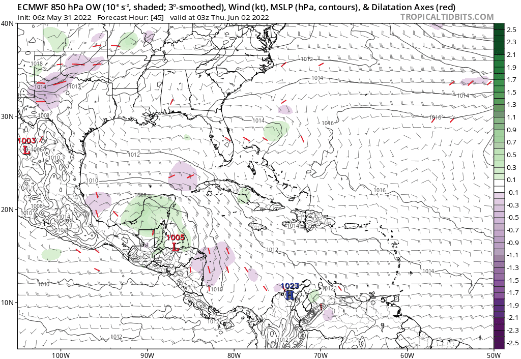
Rule #1 - Upper level divergence can do wonders toward kick-starting a fairly saturated rising column of air and it may have that going for it by mid to late week.
Rule #2 - A decent surface pressure gradient would certainly aid itself toward developing a singular low level vortex, yet the models continue to suggest a fairly flat pattern with a broad area of generally low pressures over the E. GOM and Florida waters over the next week.
Rule #3 - It'll be the 1st week of June, so expect to see a large hairball and not much more LMBO. I mean c'mon, you don't exactly walk into a flea-market with the hope of finding frest Maine lobster for lunch do ya?
Rule #4 - None of the above matters 'cause it'll trek close enough to the US in (this case the Fla. Peninsula), that some quick ASCAT or Microwave pass, Recon, Satellite T numbers, or passing cruise ship with a very elevated anenometer will verify a 35 kt. wind (somewhere).
Conclusion: In these times it's less about the actualized impact from a legit deepening semi- symetrical Tropical Storm then it is about spotting that potential wolf and then warning everyone about it. Therefore, I am quite confident that we'll be tracking Alex. The ingredients are expected to be there even IF model clarity is meh. Therefore why forecast the weather when one can forecast the forecaster Okay "Alex", we're breathlessly waiting - lets see what you've actually got. I think it's already time to look out for Bonnie
Rule #2 - A decent surface pressure gradient would certainly aid itself toward developing a singular low level vortex, yet the models continue to suggest a fairly flat pattern with a broad area of generally low pressures over the E. GOM and Florida waters over the next week.
Rule #3 - It'll be the 1st week of June, so expect to see a large hairball and not much more LMBO. I mean c'mon, you don't exactly walk into a flea-market with the hope of finding frest Maine lobster for lunch do ya?
Rule #4 - None of the above matters 'cause it'll trek close enough to the US in (this case the Fla. Peninsula), that some quick ASCAT or Microwave pass, Recon, Satellite T numbers, or passing cruise ship with a very elevated anenometer will verify a 35 kt. wind (somewhere).
Conclusion: In these times it's less about the actualized impact from a legit deepening semi- symetrical Tropical Storm then it is about spotting that potential wolf and then warning everyone about it. Therefore, I am quite confident that we'll be tracking Alex. The ingredients are expected to be there even IF model clarity is meh. Therefore why forecast the weather when one can forecast the forecaster
4 likes
Andy D
(For official information, please refer to the NHC and NWS products.)
(For official information, please refer to the NHC and NWS products.)
Re: Near Yucatán / NW Caribbean possible development?
If our system ticks much more southward it could easily keep most of the sensible wx (primarily rainfall) south of the state. Certainly possible considering up until this point it has looked like a primarily south Florida ( and secondarily east central FL) event.
1 likes
Re: Near Yucatán / NW Caribbean possible development?
For the North Atlantic...Caribbean Sea and the Gulf of Mexico:
Near the Yucatan Peninsula and Southeastern Gulf of Mexico:
A large and complex area of low pressure is expected to develop near
the Yucatan Peninsula and the northwestern Caribbean Sea in a couple
of days, partially related to the remnants of Tropical Storm Agatha
from the eastern Pacific. Despite strong upper-level winds over the
area, this system could become a tropical depression while it moves
northeastward over the northwestern Caribbean Sea and southeastern
Gulf of Mexico late this week. Regardless of development, locally
heavy rainfall is likely across portions of southeastern Mexico, the
Yucatan Peninsula, Guatemala, and Belize during the next few days,
spreading across western Cuba, southern Florida, and the Florida
Keys by the end of the week.
* Formation chance through 48 hours...low...near 0 percent.
* Formation chance through 5 days...medium...60 percent.
1 likes
-
skyline385
- Category 5
- Posts: 2728
- Age: 35
- Joined: Wed Aug 26, 2020 11:15 pm
- Location: Houston TX
Re: Near Yucatán / NW Caribbean possible development?
Latest EURO has a much more spread out rain event

0 likes
-
ouragans

- Category 2
- Posts: 501
- Age: 54
- Joined: Sun Jun 12, 2011 12:09 pm
- Location: Abymes, Guadeloupe F.W.I
- Contact:
Re: Near Yucatán / SE Gulf of Mexico development
NWS National Hurricane Center Miami FL
800 AM EDT Tue May 31 2022
For the North Atlantic...Caribbean Sea and the Gulf of Mexico:
Near the Yucatan Peninsula and Southeastern Gulf of Mexico:
A large and complex area of low pressure is expected to develop near
the Yucatan Peninsula and the northwestern Caribbean Sea in a couple
of days, partially related to the remnants of Agatha from the
eastern Pacific. Despite strong upper-level winds over the area,
this system could become a tropical depression while it moves
northeastward over the northwestern Caribbean Sea and southeastern
Gulf of Mexico late this week. Regardless of development, locally
heavy rainfall is likely across portions of southeastern Mexico, the
Yucatan Peninsula, Guatemala, and Belize during the next few days,
spreading across western Cuba, southern Florida, and the Florida
Keys by the end of the week.
* Formation chance through 48 hours...low...10 percent.
* Formation chance through 5 days...medium...60 percent.
0 likes
Personal forecast disclaimer
This post is a personal point of view, not an information. Please refer to official statements for life-threatening decisions.
David '79, Frederic '79, Hugo '89, Iris, Luis & Marilyn '95, Georges '98, Lenny '99, Dean '07, Irma '17, Maria '17, Fiona '22, Philippe '23, Tammy '23
16°13'33.3,"6N -61°36'39.5"W
-
Blown Away

- S2K Supporter

- Posts: 10253
- Joined: Wed May 26, 2004 6:17 am
Re: Near Yucatán / SE Gulf of Mexico development
Does Pacific Agatha become Alex in the Atlantic Basin if it develops again?

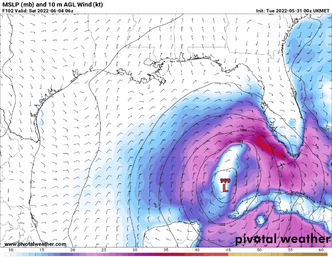
Euro predicting 40-60+ gusts for SWFL, Keys, SFL beginning Friday.
Euro predicting 40-60+ gusts for SWFL, Keys, SFL beginning Friday.
0 likes
Hurricane Eye Experience: David 79, Irene 99, Frances 04, Jeanne 04, Wilma 05… Hurricane Brush Experience: Andrew 92, Erin 95, Floyd 99, Matthew 16, Irma 17, Ian 22, Nicole 22…
-
skyline385
- Category 5
- Posts: 2728
- Age: 35
- Joined: Wed Aug 26, 2020 11:15 pm
- Location: Houston TX
Re: Near Yucatán / SE Gulf of Mexico development
NHC seems to be forecasting Agatha to dissipate over CA so the remnants will be Alex in the Gulf
0 likes
-
SFLcane

- S2K Supporter
- Posts: 10281
- Age: 48
- Joined: Sat Jun 05, 2010 1:44 pm
- Location: Lake Worth Florida
Re: Near Yucatán / SE Gulf of Mexico development
Euro is consistent. GFS is too though. One of them is gonna take an L here for sure
2 likes
-
skyline385
- Category 5
- Posts: 2728
- Age: 35
- Joined: Wed Aug 26, 2020 11:15 pm
- Location: Houston TX
Re: Near Yucatán / SE Gulf of Mexico development
SFLcane wrote:Euro is consistent. GFS is too though. One of them is gonna take an L here for sure
I checked UKMET earlier this morning and it's siding with the EURO still.
However, both ICON and CMC have shifted south in the last few runs to be more in line with GFS.
0 likes
-
tolakram
- Admin

- Posts: 20186
- Age: 62
- Joined: Sun Aug 27, 2006 8:23 pm
- Location: Florence, KY (name is Mark)
Re: Near Yucatán / SE Gulf of Mexico development
I'm still all in for the GFS solution since this is one of the areas the model gets right over and over. Heavily sheared system with a center that continues to reform south and east into the convection.
1 likes
M a r k
- - - - -
Join us in chat: Storm2K Chatroom Invite. Android and IOS apps also available.
The posts in this forum are NOT official forecasts and should not be used as such. Posts are NOT endorsed by any professional institution or STORM2K.org. For official information and forecasts, please refer to NHC and NWS products.
-
Blown Away
- S2K Supporter
- Posts: 10253
- Joined: Wed May 26, 2004 6:17 am
Re: Near Yucatán / SE Gulf of Mexico development

GFS
0 likes
Hurricane Eye Experience: David 79, Irene 99, Frances 04, Jeanne 04, Wilma 05… Hurricane Brush Experience: Andrew 92, Erin 95, Floyd 99, Matthew 16, Irma 17, Ian 22, Nicole 22…

Re: Near Yucatán / SE Gulf of Mexico development
Two noticeable vortices this morning, the one from Agatha in southern MX and one over northern Belize.
Might be why the models have different solutions.

Might be why the models have different solutions.
6 likes
Who is online
Users browsing this forum: pepecool20, Ulf and 246 guests