Tropical Wave East of the Windward Islands (Is Invest 98L)
Moderator: S2k Moderators
Forum rules

The posts in this forum are NOT official forecasts and should not be used as such. They are just the opinion of the poster and may or may not be backed by sound meteorological data. They are NOT endorsed by any professional institution or STORM2K. For official information, please refer to products from the National Hurricane Center and National Weather Service.
-
SFLcane

- S2K Supporter

- Posts: 10281
- Age: 48
- Joined: Sat Jun 05, 2010 1:44 pm
- Location: Lake Worth Florida
Re: Tropical Wave over the Central Atlantic (0/20)
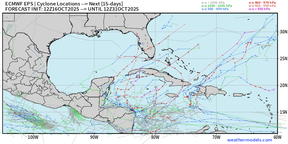
12z Euro is into the gulf of gulf of honduras again.
0 likes
Re: Tropical Wave over the Central Atlantic (0/20)
TomballEd wrote:zzzh wrote:https://i.imgur.com/pZtpG6K.png
ECAI finally on board (the last model to do this), showing the wave strengthening and stalling around 75W-80W 15N for a whopping 8 days
The world doesn't need another Hurricane Mitch.
Fwiw due to it being way out in fantasyland, the 12Z Euro has Mitch-like/Eta-like/Iota-like flooding in N Honduras as it stalls just to the N of Honduras for a few days and intensifies followed by E and then ENE/NE movement to W of Jamaica headed toward C Cuba at the end as a trough picks it up.
1 likes
Personal Forecast Disclaimer:
The posts in this forum are NOT official forecasts and should not be used as such. They are just the opinion of the poster and may or may not be backed by sound meteorological data. They are NOT endorsed by any professional institution or storm2k.org. For official information, please refer to the NHC and NWS products.
The posts in this forum are NOT official forecasts and should not be used as such. They are just the opinion of the poster and may or may not be backed by sound meteorological data. They are NOT endorsed by any professional institution or storm2k.org. For official information, please refer to the NHC and NWS products.
-
cycloneye

- Admin

- Posts: 149638
- Age: 69
- Joined: Thu Oct 10, 2002 10:54 am
- Location: San Juan, Puerto Rico
Re: Tropical Wave over the Central Atlantic (0/20)
Here is the whole 12z Euro run. I only say yikes 

2 likes
Visit the Caribbean-Central America Weather Thread where you can find at first post web cams,radars
and observations from Caribbean basin members Click Here
and observations from Caribbean basin members Click Here

Re: Tropical Wave over the Central Atlantic (0/20)
Euro says hold my beer..

Last edited by blp on Thu Oct 16, 2025 1:35 pm, edited 2 times in total.
3 likes
The following post is NOT an official forecast and should not be used as such. It is just the opinion of the poster and may or may not be backed by sound meteorological data. It is NOT endorsed by any professional institution including storm2k.org For Official Information please refer to the NHC and NWS products.
-
SFLcane
- S2K Supporter
- Posts: 10281
- Age: 48
- Joined: Sat Jun 05, 2010 1:44 pm
- Location: Lake Worth Florida
Re: Tropical Wave over the Central Atlantic (0/20)
another 50 miles east near the yucatan and that clips keys/sfl. Long ways to go
1 likes
Re: Tropical Wave over the Central Atlantic (0/20)
Ukmet.. If this played out further it looks like it would be similar to Euro.

0 likes
The following post is NOT an official forecast and should not be used as such. It is just the opinion of the poster and may or may not be backed by sound meteorological data. It is NOT endorsed by any professional institution including storm2k.org For Official Information please refer to the NHC and NWS products.
Re: Tropical Wave over the Central Atlantic (0/20)
EURO wants a "party like it's 1999" wrong way Lenny redux
4 likes
-
Cachondo23
- Tropical Storm

- Posts: 131
- Joined: Wed May 25, 2022 5:56 am
Re: Tropical Wave over the Central Atlantic (0/20)
psyclone wrote:EURO wants a "party like it's 1999" wrong way Lenny redux
Was thinking of that! Euro wants a strong wrong way Lenny and GFS a weak one. In the end, it looks like something would be moving east when developed…
0 likes
-
TomballEd
- Category 5

- Posts: 1310
- Age: 62
- Joined: Wed Aug 16, 2023 4:52 pm
- Location: Spring/Klein area, not Tomball
Re: Tropical Wave over the Central Atlantic (0/20)
Cachondo23 wrote:psyclone wrote:EURO wants a "party like it's 1999" wrong way Lenny redux
Was thinking of that! Euro wants a strong wrong way Lenny and GFS a weak one. In the end, it looks like something would be moving east when developed…
Eastward movement in an end of October storm would not be abnormal.

1 likes
Re: Tropical Wave over the Central Atlantic (0/20)
What was left of Mitch did cross the Florida peninsula, so ya never know.
0 likes
Re: Tropical Wave over the Central Atlantic (0/20)
12z DeepMind


0 likes
The following post is NOT an official forecast and should not be used as such. It is just the opinion of the poster and may or may not be backed by sound meteorological data. It is NOT endorsed by any professional institution including storm2k.org For Official Information please refer to the NHC and NWS products.
Re: Tropical Wave over the Central Atlantic (0/20)
If the Euro holds up and Cuba vanishes into thin air Florida could be in for a really big hit. Third cat 5 of the season coming up? Probably not.
0 likes
-
TomballEd
- Category 5
- Posts: 1310
- Age: 62
- Joined: Wed Aug 16, 2023 4:52 pm
- Location: Spring/Klein area, not Tomball
Re: Tropical Wave over the Central Atlantic (0/20)
ljmac75 wrote:If the Euro holds up and Cuba vanishes into thin air Florida could be in for a really big hit. Third cat 5 of the season coming up? Probably not.
This would be in the Caribbean about the same time of year as Mitch. If it stalls it could make a run at Cat 5. Assuming it doesn't get recurved quickly or plows into Central America, which the ensembles suggests are distinct possibilities.
1 likes

Re: Tropical Wave over the Central Atlantic (0/20)
TomballEd wrote:ljmac75 wrote:If the Euro holds up and Cuba vanishes into thin air Florida could be in for a really big hit. Third cat 5 of the season coming up? Probably not.
This would be in the Caribbean about the same time of year as Mitch. If it stalls it could make a run at Cat 5. Assuming it doesn't get recurved quickly or plows into Central America, which the ensembles suggests are distinct possibilities.
Another thing to keep in mind is the SW Caribbean has basically been untouched by any tropical cyclones this season. Lots of untapped heat potential combined with forecasts of an upper level high overhead in the region makes a "Mitch-like" storm possible.
2 likes
Re: Tropical Wave over the Central Atlantic (0/20)
Happy Hour GFS is even further E with a NE move over far E PR and the Virgin Islands of a strengthening cat 1 H 10/24-5.
0 likes
Personal Forecast Disclaimer:
The posts in this forum are NOT official forecasts and should not be used as such. They are just the opinion of the poster and may or may not be backed by sound meteorological data. They are NOT endorsed by any professional institution or storm2k.org. For official information, please refer to the NHC and NWS products.
The posts in this forum are NOT official forecasts and should not be used as such. They are just the opinion of the poster and may or may not be backed by sound meteorological data. They are NOT endorsed by any professional institution or storm2k.org. For official information, please refer to the NHC and NWS products.
Re: Tropical Wave over the Central Atlantic (0/20)
LarryWx wrote:Happy Hour GFS is even further E with a NE move over far E PR and the Virgin Islands of a strengthening cat 1 H 10/24-5.
The ensembles say the ops run is out to lunch. Ops is furthest east.

5 likes
The following post is NOT an official forecast and should not be used as such. It is just the opinion of the poster and may or may not be backed by sound meteorological data. It is NOT endorsed by any professional institution including storm2k.org For Official Information please refer to the NHC and NWS products.
-
AJC3

- Admin
- Posts: 4156
- Age: 62
- Joined: Tue Aug 31, 2004 7:04 pm
- Location: Ballston Spa, New York
- Contact:
Re: Tropical Wave over the Central Atlantic (0/20)
Tropical Weather Discussion
NWS National Hurricane Center Miami FL
0015 UTC Fri Oct 17 2025
...TROPICAL WAVES...
The axis of an central Atlantic tropical wave is near 34.5W S of
15N, and moving west around 15 to 20 kt. Scattered moderate to
isolated strong convection is noted from 03N to 14N between 31W
and 39W.
NWS National Hurricane Center Miami FL
0015 UTC Fri Oct 17 2025
...TROPICAL WAVES...
The axis of an central Atlantic tropical wave is near 34.5W S of
15N, and moving west around 15 to 20 kt. Scattered moderate to
isolated strong convection is noted from 03N to 14N between 31W
and 39W.
1 likes
-
cycloneye
- Admin
- Posts: 149638
- Age: 69
- Joined: Thu Oct 10, 2002 10:54 am
- Location: San Juan, Puerto Rico
Re: Tropical Wave over the Central Atlantic (10/30)
Tropical Weather Outlook
NWS National Hurricane Center Miami FL
800 PM EDT Thu Oct 16 2025
East of the Windward Islands into the Caribbean Sea:
A tropical wave currently located over the central tropical Atlantic
is associated with a large area of showers and thunderstorms. Some
gradual development of this system is possible over the next several
days as it moves westward at 15 to 20 mph. Regardless of
development, heavy rainfall and gusty winds are possible as the
system moves across the Windward Islands late this weekend and
enters the Caribbean Sea by the early to middle part of next week.
* Formation chance through 48 hours...low...10 percent.
* Formation chance through 7 days...low...30 percent.

2 likes
Visit the Caribbean-Central America Weather Thread where you can find at first post web cams,radars
and observations from Caribbean basin members Click Here
and observations from Caribbean basin members Click Here
-
Blown Away

- S2K Supporter
- Posts: 10253
- Joined: Wed May 26, 2004 6:17 am
Re: Tropical Wave over the Central Atlantic (10/30)
4 likes
Hurricane Eye Experience: David 79, Irene 99, Frances 04, Jeanne 04, Wilma 05… Hurricane Brush Experience: Andrew 92, Erin 95, Floyd 99, Matthew 16, Irma 17, Ian 22, Nicole 22…
Who is online
Users browsing this forum: Ulf, Yellow Evan and 276 guests