NotSparta wrote:SFLcane wrote:Lots of wavebreaking and dry air issues. Party like it's 2013
2013 and wavebreaking in the same post, that's two shots folks
Well, its clearly what the gfs op shows basically 2013 and some.
Moderator: S2k Moderators


NotSparta wrote:SFLcane wrote:Lots of wavebreaking and dry air issues. Party like it's 2013
2013 and wavebreaking in the same post, that's two shots folks


SFLcane wrote:NotSparta wrote:SFLcane wrote:Lots of wavebreaking and dry air issues. Party like it's 2013
2013 and wavebreaking in the same post, that's two shots folks
Well, its clearly what the gfs op shows basically 2013 and some.
SFLcane wrote:LarryWx wrote:kevin wrote:06z GFS operational perhaps has one or two TDs in the WCar/GOM, but the main action is in the MDR with the first system starting to form at +114 hours. Eventually becomes a MH (looks OTS in this specific run). Behind it are two new TCs in the MDR. Until we actually have a defined source or already a TC, the ensembles are probably more valuable than single operational runs though.
https://i.imgur.com/XGQIOAp.png
https://i.imgur.com/Swn4yOp.png
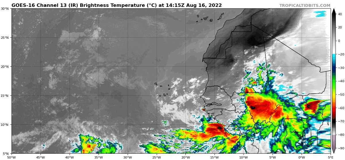
Just to clarify for those who may not be following closely, this is the same wave that the GFS from 5 runs earlier (0Z of 8/15/22) had as a hurricane hitting the Leewards on 8/29-30. Energy/moisture that comes off Africa to lead to this developing is per this run convection that is currently already centered over SW Mali near 7W, 12N, and already starts emerging from Africa tomorrow evening near 12N just as it did on yesterday's 0Z run. Because operational runs generally have little reliability going too far out in time, I think it is important to note how soon the seed from this potential trouble hits water and how far west it already is in Africa so that it can be followed closely. I'll try to see if I can see it on satellite.
I mean this is the wave the GEFS is developing.
https://i.postimg.cc/VN3L0g0k/gefs.gif


SFLcane wrote:Scratching my head... If its so favorable why isn't the ecm developing this?
https://i.postimg.cc/XNQ1KkbV/gfs22.gif

SFLcane wrote:Scratching my head... If its so favorable why isn't the ecm developing this?
https://i.postimg.cc/XNQ1KkbV/gfs22.gif

LarryWx wrote:SFLcane wrote:Scratching my head... If its so favorable why isn't the ecm developing this?
https://i.postimg.cc/XNQ1KkbV/gfs22.gif
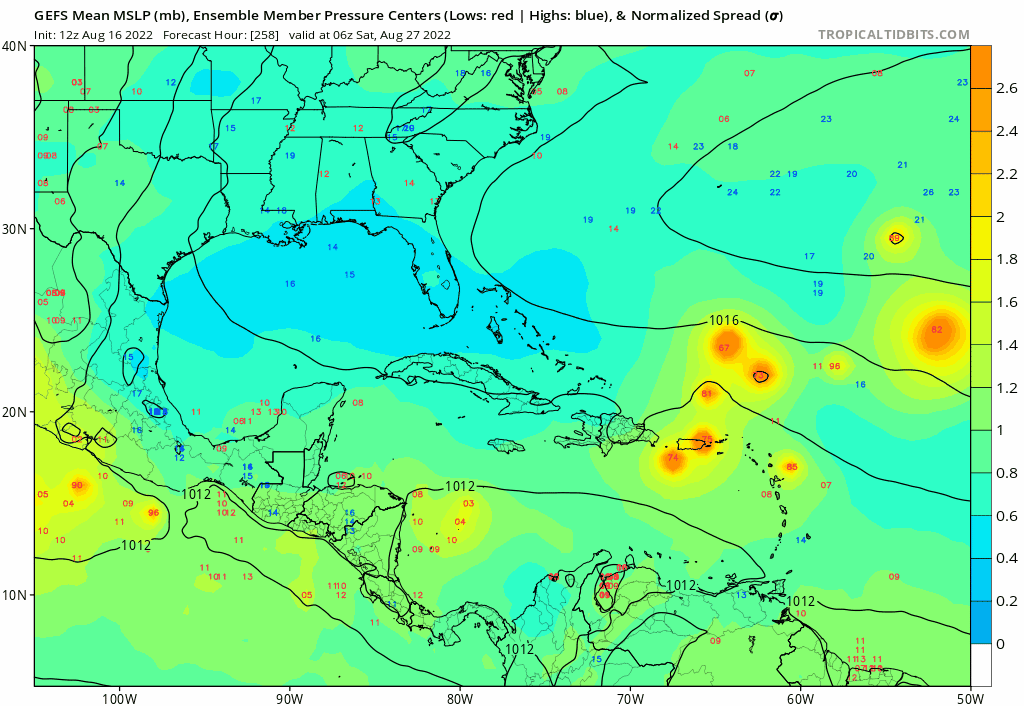
Among other locations affected out of the 31 or so members, there are 3 12Z GEFS members with Hs that later directly affect PR. Also, there are 4 that later landfall on the SE CONUS as cat 2+ Hs along with several others threatening at the end of the run. If not the most threatening GEFS run to date for the US, I think this run almost has to be close to the worst run yet this season. These are almost 100% from that AEW that is currently over SW Mali and soon to emerge from Africa. Keep a watchful eye on it for ~8/25+ in the Caribbean and ~8/29+ in the CONUS. Hopefully it will not end up a problem, of course, and be careful what you wish for (not that wishing has any effect)!


Spacecoast wrote:LarryWx wrote:SFLcane wrote:Scratching my head... If its so favorable why isn't the ecm developing this?
https://i.postimg.cc/XNQ1KkbV/gfs22.gif
Among other locations affected out of the 31 or so members, there are 3 12Z GEFS members with Hs that later directly affect PR. Also, there are 4 that later landfall on the SE CONUS as cat 2+ Hs along with several others threatening at the end of the run. If not the most threatening GEFS run to date for the US, I think this run almost has to be close to the worst run yet this season. These are almost 100% from that AEW that is currently over SW Mali and soon to emerge from Africa. Keep a watchful eye on it for ~8/25+ in the Caribbean and ~8/29+ in the CONUS. Hopefully it will not end up a problem, of course, and be careful what you wish for (not that wishing has any effect)!
Not to mention 4 members approaching SFL.
Definitely something to watch.....
I count 6-8 members (~22%) that survive the trek past 40W. Some not appearing until past 60W (@~240Hr).
Perhaps 18Z will have more members

skyline385 wrote:Kingarabian wrote:skyline385 wrote:The problem is that the EPS has them at TS strength in the middle of Africa not near the coastline lol. So i have to agree with Andy that there is most definitely an overdeepening bias in the EPS when inland.
https://uploads.tapatalk-cdn.com/20220816/d5bbe991c7b2eaac5ebb14733b3317e7.jpg
Sent from my iPhone using Tapatalk
Yeah I agree but IMO it's just a weird thing the model does when it wants to show a wave will likely have a good shot at developing.
Agree on that, it’s probably a decent indicator of an incoming strong AEW.
Sent from my iPhone using Tapatalk
jlauderdal wrote:
Offshore of Lake Worth, yikes


jlauderdal wrote:SFLcane wrote::eek:
image removed
Offshore of Lake Worth, yikes
skyline385 wrote:jlauderdal wrote:
Offshore of Lake Worth, yikes
Full run of the EPS, 12 GEFS also had similar members but slightly stronger ridge with some getting into the Gulf near the keys.
https://uploads.tapatalk-cdn.com/20220816/eb9c3aba2dc85e5b98572464664df94d.jpg
Sent from my iPhone using Tapatalk
SFLcane wrote:Scratching my head... If its so favorable why isn't the ecm developing this?
https://i.postimg.cc/XNQ1KkbV/gfs22.gif


Users browsing this forum: No registered users and 275 guests


