2023 Global Model Runs Discussion (Out thru day 16)

This is the general tropical discussion area. Anyone can take their shot at predicting a storms path.

Moderator: S2k Moderators

Forum rules

The posts in this forum are NOT official forecasts and should not be used as such. They are just the opinion of the poster and may or may not be backed by sound meteorological data. They are NOT endorsed by any professional institution or STORM2K. For official information, please refer to products from the National Hurricane Center and National Weather Service.

Help Support Storm2K
Message
Author
User avatar
Hurricane2022
Category 5
Category 5
Posts: 1498
Joined: Tue Aug 23, 2022 11:38 pm
Location: Araçatuba, Brazil

Re: 2023 Global Model Runs Discussion (Out thru day 16)

#1441 Postby Hurricane2022 » Fri Sep 08, 2023 6:56 pm


Happy hour GFS!!! :yow: :band: :moon: :boog: :Partytime: :woo:
1 likes   
Sorry for the bad English sometimes...!
For reliable and detailed information for any meteorological phenomenon, please consult the National Hurricane Center, Joint Typhoon Warning Center , or your local Meteo Center.

--------

Una cvm Christo, pro Christo, et in Christo. Sit nomen Domini benedictvm.

User avatar
Category5Kaiju
Category 5
Category 5
Posts: 4055
Joined: Thu Dec 24, 2020 12:45 pm
Location: Seattle

Re: 2023 Global Model Runs Discussion (Out thru day 16)

#1442 Postby Category5Kaiju » Fri Sep 08, 2023 7:05 pm

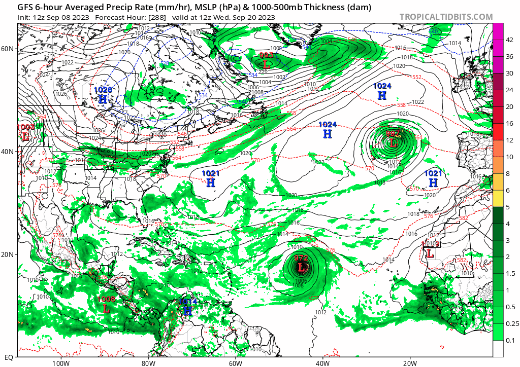
Blown Away wrote:[url]https://i.postimg.cc/6qw7vGXZ/gfs-mslp-pcpn-watl-fh210-384-2.gif [/url]
18z GFS… Goes over Hispaniola & Cuba and maintains MH into KW and EGOM…


It's a wanna-be Georges lol
3 likes   
Unless explicitly stated, all info in my posts is based on my own opinions and observations. Tropical storms and hurricanes can be extremely dangerous. Do not think you can beat Mother Nature. Refer to an accredited weather research agency or meteorologist if you need to make serious decisions regarding an approaching storm.

Ianswfl
Category 1
Category 1
Posts: 482
Joined: Thu Mar 23, 2023 11:11 pm

Re: 2023 Global Model Runs Discussion (Out thru day 16)

#1443 Postby Ianswfl » Fri Sep 08, 2023 7:10 pm

Category5Kaiju wrote:
Blown Away wrote: https://i.postimg.cc/6qw7vGXZ/gfs-mslp- ... -384-2.gif
18z GFS… Goes over Hispaniola & Cuba and maintains MH into KW and EGOM…


It's a wanna-be Georges lol


Except stronger. Almost looks like the path up the west coast of FL that Irma was forecasted to do. Keys and landfall around Sarasota.

This GFS run would be the knockout blow to Ft. Myers Beach, Sanibel and that. Would never see full recovery.
1 likes   

emeraldislenc
Category 2
Category 2
Posts: 558
Joined: Fri Aug 24, 2012 4:49 pm
Location: Emerald Isle NC

Re: 2023 Global Model Runs Discussion (Out thru day 16)

#1444 Postby emeraldislenc » Fri Sep 08, 2023 8:13 pm

I really enjoy storm 2k but I must admit there are two phrases that are so overused and I get so tired of hearing:
1 Fish Storm
2. Happy hour run

Not trying to upset anyone but just being honest!
I do appreciate the great and informing post!
7 likes   

User avatar
gatorcane
S2K Supporter
S2K Supporter
Posts: 23689
Age: 47
Joined: Sun Mar 13, 2005 3:54 pm
Location: Boca Raton, FL

Re: 2023 Global Model Runs Discussion (Out thru day 16)

#1445 Postby gatorcane » Fri Sep 08, 2023 8:27 pm

Almost as much activity in this thread on the GFS phantom Caribbean-EGOM hurricane as Lee because it is a threat to Florida. Just take a look at the ensembles in which there are zero that show that scenario, all of them recurve over the Central Atlantic. Given we are heading into mid-September looks reasonable:

Image
0 likes   

User avatar
MetroMike
Category 4
Category 4
Posts: 944
Joined: Sun Aug 29, 2004 8:13 pm
Location: Tampa Bay
Contact:

Re: 2023 Global Model Runs Discussion (Out thru day 16)

#1446 Postby MetroMike » Fri Sep 08, 2023 8:37 pm

The 12z CMC had a similar system but not as progressed. Maybe it’s sniffing out favorable areas.
0 likes   

Ianswfl
Category 1
Category 1
Posts: 482
Joined: Thu Mar 23, 2023 11:11 pm

Re: 2023 Global Model Runs Discussion (Out thru day 16)

#1447 Postby Ianswfl » Fri Sep 08, 2023 8:51 pm

MetroMike wrote:The 12z CMC had a similar system but not as progressed. Maybe it’s sniffing out favorable areas.


Saw that too. CMC has something trying to brew in the Western Carribean at the end of the run btw.

Image
0 likes   

User avatar
SFLcane
S2K Supporter
S2K Supporter
Posts: 10162
Age: 47
Joined: Sat Jun 05, 2010 1:44 pm
Location: Lake Worth Florida

Re: 2023 Global Model Runs Discussion (Out thru day 16)

#1448 Postby SFLcane » Fri Sep 08, 2023 10:00 pm

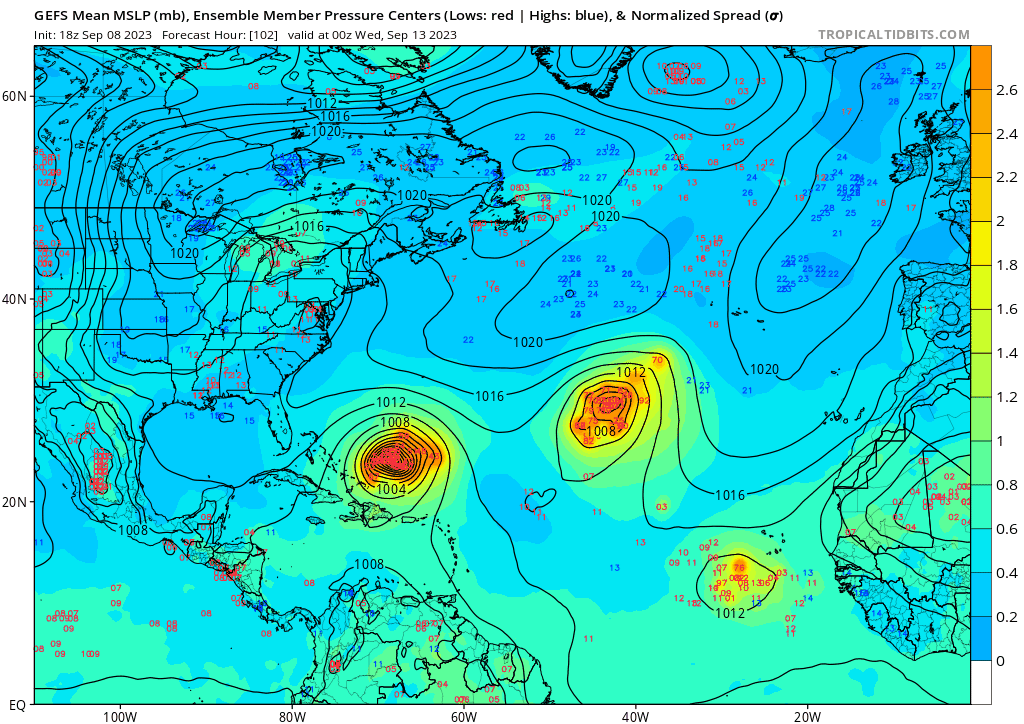
gatorcane wrote:Almost as much activity in this thread on the GFS phantom Caribbean-EGOM hurricane as Lee because it is a threat to Florida. Just take a look at the ensembles in which there are zero that show that scenario, all of them recurve over the Central Atlantic. Given we are heading into mid-September looks reasonable:

https://i.postimg.cc/FF8437nk/gfs-ememb-lowlocs-atl-fh102-228.gif


Ok one thing is the GEFS ensembles show a totally different solution and you have about one hour to enjoy that happy hour run before it’s gone but to say it looks reasonable for mid September with all do respect is nonsense. There have been plenty of tcs during mid sept that have hit the conus. :roll:
1 likes   

floridasun
Tropical Storm
Tropical Storm
Posts: 196
Joined: Tue Sep 14, 2021 3:59 pm

Re: 2023 Global Model Runs Discussion (Out thru day 16)

#1449 Postby floridasun » Fri Sep 08, 2023 10:05 pm

Ianswfl wrote:
MetroMike wrote:The 12z CMC had a similar system but not as progressed. Maybe it’s sniffing out favorable areas.


Saw that too. CMC has something trying to brew in the Western Carribean at the end of the run btw.

https://pbs.twimg.com/media/F5i1ijbWYAAJsXd?format=jpg&name=small

That look like Wilma
0 likes   

User avatar
Category5Kaiju
Category 5
Category 5
Posts: 4055
Joined: Thu Dec 24, 2020 12:45 pm
Location: Seattle

Re: 2023 Global Model Runs Discussion (Out thru day 16)

#1450 Postby Category5Kaiju » Fri Sep 08, 2023 10:27 pm

floridasun wrote:
Ianswfl wrote:
MetroMike wrote:The 12z CMC had a similar system but not as progressed. Maybe it’s sniffing out favorable areas.


Saw that too. CMC has something trying to brew in the Western Carribean at the end of the run btw.

https://pbs.twimg.com/media/F5i1ijbWYAAJsXd?format=jpg&name=small

That look like Wilma


Or Ian
0 likes   
Unless explicitly stated, all info in my posts is based on my own opinions and observations. Tropical storms and hurricanes can be extremely dangerous. Do not think you can beat Mother Nature. Refer to an accredited weather research agency or meteorologist if you need to make serious decisions regarding an approaching storm.

User avatar
toad strangler
S2K Supporter
S2K Supporter
Posts: 4543
Joined: Sun Jul 28, 2013 3:09 pm
Location: Earth
Contact:

Re: 2023 Global Model Runs Discussion (Out thru day 16)

#1451 Postby toad strangler » Sat Sep 09, 2023 7:27 am

Category5Kaiju wrote:
floridasun wrote:
Ianswfl wrote:
Saw that too. CMC has something trying to brew in the Western Carribean at the end of the run btw.

https://pbs.twimg.com/media/F5i1ijbWYAAJsXd?format=jpg&name=small

That look like Wilma


Or Ian


No way, Ian’s eye was nowhere near that size. Definitely looks like Wilma’s sister lol
0 likes   

User avatar
SFLcane
S2K Supporter
S2K Supporter
Posts: 10162
Age: 47
Joined: Sat Jun 05, 2010 1:44 pm
Location: Lake Worth Florida

Re: 2023 Global Model Runs Discussion (Out thru day 16)

#1452 Postby SFLcane » Sat Sep 09, 2023 8:07 am

toad strangler wrote:
Category5Kaiju wrote:
floridasun wrote:That look like Wilma


Or Ian


No way, Ian’s eye was nowhere near that size. Definitely looks like Wilma’s sister lol


Thankfully it’s gone… wasn’t even supported by GEFS.
2 likes   

mantis83
Tropical Storm
Tropical Storm
Posts: 198
Joined: Fri Dec 05, 2003 4:47 pm

Re: 2023 Global Model Runs Discussion (Out thru day 16)

#1453 Postby mantis83 » Sat Sep 09, 2023 11:41 am

relentless troughs on the 12z gfs and cmc, scooping up anything that tries to come close..... :fishing:
0 likes   

User avatar
Blown Away
S2K Supporter
S2K Supporter
Posts: 10140
Joined: Wed May 26, 2004 6:17 am

Re: 2023 Global Model Runs Discussion (Out thru day 16)

#1454 Postby Blown Away » Sat Sep 09, 2023 11:46 am

Image
GFS run to run consistency with next hurricane… :yesno:
2 likes   
Hurricane Eye Experience: David 79, Irene 99, Frances 04, Jeanne 04, Wilma 05... EYE COMING MY WAY IN 2024…
Hurricane Brush Experience: Andrew 92, Erin 95, Floyd 99, Matthew 16, Irma 17, Ian 22, Nicole 22…

jhpigott
Category 2
Category 2
Posts: 570
Joined: Wed Jan 02, 2008 8:09 pm
Location: North Palm Beach, Florida

Re: 2023 Global Model Runs Discussion (Out thru day 16)

#1455 Postby jhpigott » Sat Sep 09, 2023 11:48 am

mantis83 wrote:relentless troughs on the 12z gfs and cmc, scooping up anything that tries to come close..... :fishing:


Which is great during Cape Verde season for us here in CONUS. Not so much when/if things get cranking in the WCAR during late Sept thru November
0 likes   

User avatar
gatorcane
S2K Supporter
S2K Supporter
Posts: 23689
Age: 47
Joined: Sun Mar 13, 2005 3:54 pm
Location: Boca Raton, FL

Re: 2023 Global Model Runs Discussion (Out thru day 16)

#1456 Postby gatorcane » Sat Sep 09, 2023 11:59 am

mantis83 wrote:relentless troughs on the 12z gfs and cmc, scooping up anything that tries to come close..... :fishing:


Yep but the indicators for this season strongly suggested this is the pattern we would see so it should be of no surprise. One reason why the west coast of Florida experienced a record drought is due to lack of easterlies this summer.

For those looking for a Florida peninsula hit from a significant system (i.e., a major hurricane), it likely would need to come from the south but we should see El Niño shear start kicking in by October so chances could be less than an average. Something sheared is certainly possible.

Image
0 likes   

User avatar
MetroMike
Category 4
Category 4
Posts: 944
Joined: Sun Aug 29, 2004 8:13 pm
Location: Tampa Bay
Contact:

Re: 2023 Global Model Runs Discussion (Out thru day 16)

#1457 Postby MetroMike » Sat Sep 09, 2023 12:06 pm

gatorcane wrote:
mantis83 wrote:relentless troughs on the 12z gfs and cmc, scooping up anything that tries to come close..... :fishing:


Yep but the indicators for this season strongly suggested this is the pattern we would see so it should be of no surprise. One reason why the west coast of Florida experienced a record drought is due to lack of easterlies this summer.

For those looking for a Florida peninsula hit from a significant system (i.e., a major hurricane), it likely would need to come from the south but we should see El Niño shear start kicking in by October so chances could be less than an average. Something sheared is certainly possible.

https://i.postimg.cc/6qBdtP3x/gfs-z500a-Norm-atl-fh90-270.gif


El Nino shear in October?
Are you still in Andy Hazelton's camp with that?
0 likes   

User avatar
cycloneye
Admin
Admin
Posts: 143926
Age: 68
Joined: Thu Oct 10, 2002 10:54 am
Location: San Juan, Puerto Rico

Re: 2023 Global Model Runs Discussion (Out thru day 16)

#1458 Postby cycloneye » Sat Sep 09, 2023 12:12 pm

0 likes   
Visit the Caribbean-Central America Weather Thread where you can find at first post web cams,radars
and observations from Caribbean basin members Click Here

User avatar
gatorcane
S2K Supporter
S2K Supporter
Posts: 23689
Age: 47
Joined: Sun Mar 13, 2005 3:54 pm
Location: Boca Raton, FL

Re: 2023 Global Model Runs Discussion (Out thru day 16)

#1459 Postby gatorcane » Sat Sep 09, 2023 1:05 pm

Last few runs of the long-range GFS and GEFS are showing what look like the westerlies ripping across the Gulf and Florida in the wake of Lee. Given the El Niño, I would not be surprised if the westerlies do become more dominant over the Gulf and possibly Caribbean as we head into late September and October:

Image
0 likes   

User avatar
Kingarabian
S2K Supporter
S2K Supporter
Posts: 15829
Joined: Sat Aug 08, 2009 3:06 am
Location: Honolulu, Hawaii

Re: 2023 Global Model Runs Discussion (Out thru day 16)

#1460 Postby Kingarabian » Sat Sep 09, 2023 1:29 pm

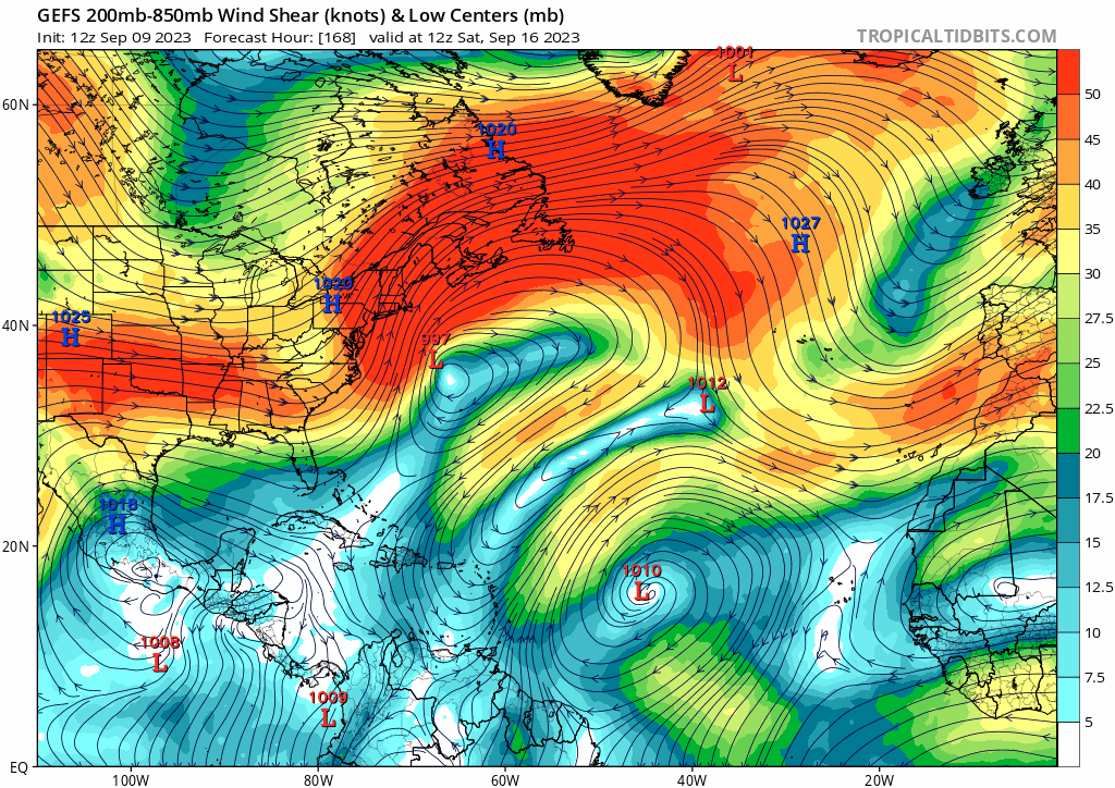
gatorcane wrote:Last few runs of the long-range GFS and GEFS are showing what look like the westerlies ripping across the Gulf and Florida in the wake of Lee. Given the El Niño, I would not be surprised if the westerlies do become more dominant over the Gulf and possibly Caribbean as we head into late September and October:

https://i.postimg.cc/Jn3r1K6b/gfs-ens-shear-atl-fh168-300.gif

That looks like a favorable shear pattern to me in the GOM. Would want those vectors to be in the Caribbean than that far north in the GOM. Any TC with a decent anti cyclone can easily create a favorable setup.
1 likes   
RIP Kobe Bryant


Return to “Talkin' Tropics”

Who is online

Users browsing this forum: MarioProtVI and 249 guests