2024 Global Model Runs Discussion (Out thru day 16)
Moderator: S2k Moderators
Forum rules

The posts in this forum are NOT official forecasts and should not be used as such. They are just the opinion of the poster and may or may not be backed by sound meteorological data. They are NOT endorsed by any professional institution or STORM2K. For official information, please refer to products from the National Hurricane Center and National Weather Service.

Re: 2024 Global Model Runs Discussion (Out thru day 16)
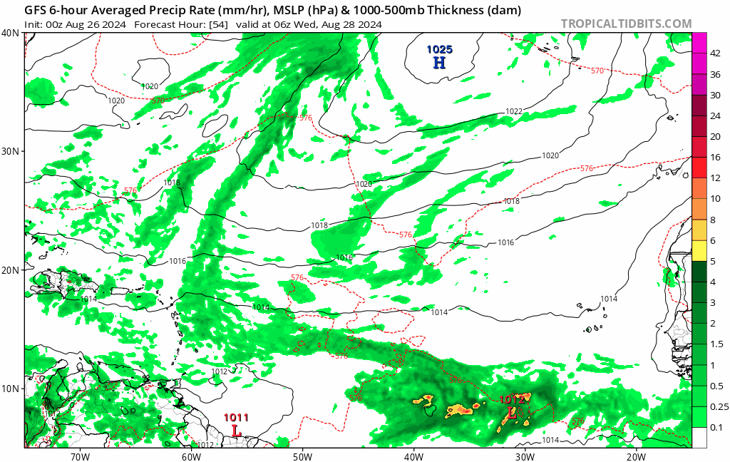
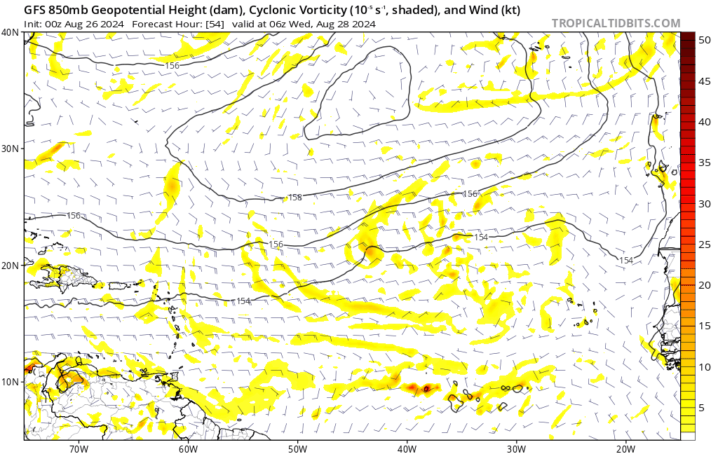
The wave expected to cross the Caribbean in late August appears to have a much less favorable environment on models today. On the op GFS, it is shredded by 40kt of shear (induced by an upper level low) as it approaches Florida.
0 likes
Kendall -> SLO -> PBC
Memorable Storms: Katrina (for its Florida landfall...) Wilma Matthew Irma
Memorable Storms: Katrina (for its Florida landfall...) Wilma Matthew Irma


Re: 2024 Global Model Runs Discussion (Out thru day 16)
Help support Storm2K!
cajungal wrote:Those wanting a hurricane just go to Pat o briens. They may be only one you get right now and at least those won’t cause widespread destruction
Depends on your definition of widespread destruction…
0 likes
-
Stratton23
- Category 5

- Posts: 3518
- Joined: Fri Jul 21, 2023 10:59 pm
- Location: Katy, Tx
Re: 2024 Global Model Runs Discussion (Out thru day 16)
I have a feeling this is going to be a season in which the models really struggle with genesis due to this problem with the monsoon trough, think we could get a few systems to form despite the globals really not handling the monsoon trough at all, ensembles are definitely having a better handle at this time, all it takes is one, and thats the big take away even in a quiet l stretch like this
4 likes

Re: 2024 Global Model Runs Discussion (Out thru day 16)
Broken record at this point, but the GFS keeps trying to develop a system in about 90 hours, only to get caught up in the monsoonal flow


0 likes
The above post is not official and should not be used as such. It is the opinion of the poster and may or may not be backed by sound meteorological data. It is not endorsed by any professional institution or storm2k.org. For official information, please refer to the NHC and NWS products.
-
MarioProtVI
- Category 5
- Posts: 1034
- Age: 24
- Joined: Sun Sep 29, 2019 7:33 pm
- Location: New Jersey
Re: 2024 Global Model Runs Discussion (Out thru day 16)
Hammy wrote:Broken record at this point, but the GFS keeps trying to develop a system in about 90 hours, only to get caught up in the monsoonal flow
https://i.imgur.com/phRNCaW.png
https://i.imgur.com/qB3WOcG.png
Think this might be a case of short-term trends i.e as it gets closer it may adjust itself if the system organizes distinctively.
2 likes
-
Stratton23
- Category 5
- Posts: 3518
- Joined: Fri Jul 21, 2023 10:59 pm
- Location: Katy, Tx
Re: 2024 Global Model Runs Discussion (Out thru day 16)
Until the monsoon trough breaks down, the only other way i could see activity getting going is if we get fronts coming down into the gulf/ se us, that could help to spark home grown activity or a CAG event in late september/ early october, those could be other ways that we get more named storms, i think its just a case where the MDR is going to be pretty hostile for the foreseeable future and maybe something has a better shot at developing in the western half of the basin, i could be completely wrong though
2 likes
-
cajungal

- Category 5
- Posts: 2354
- Age: 49
- Joined: Sun Mar 14, 2004 9:34 pm
- Location: Schriever, Louisiana (60 miles southwest of New Orleans)
Re: 2024 Global Model Runs Discussion (Out thru day 16)
It would be shocking if the season ended with Ernesto
0 likes
-
MarioProtVI
- Category 5
- Posts: 1034
- Age: 24
- Joined: Sun Sep 29, 2019 7:33 pm
- Location: New Jersey
Re: 2024 Global Model Runs Discussion (Out thru day 16)
cajungal wrote:It would be shocking if the season ended with Ernesto
That’s statistically not gonna happen. I’m sorry but that would like require a super -AMO and super Nino to occur.
4 likes
-
cajungal
- Category 5
- Posts: 2354
- Age: 49
- Joined: Sun Mar 14, 2004 9:34 pm
- Location: Schriever, Louisiana (60 miles southwest of New Orleans)
Re: 2024 Global Model Runs Discussion (Out thru day 16)
MarioProtVI wrote:cajungal wrote:It would be shocking if the season ended with Ernesto
That’s statistically not gonna happen. I’m sorry but that would like require a super -AMO and super Nino to occur.
I know. It was sarcasm
1 likes
Re: 2024 Global Model Runs Discussion (Out thru day 16)
Stratton23 wrote:Until the monsoon trough breaks down, the only other way i could see activity getting going is if we get fronts coming down into the gulf/ se us, that could help to spark home grown activity or a CAG event in late september/ early october, those could be other ways that we get more named storms, i think its just a case where the MDR is going to be pretty hostile for the foreseeable future and maybe something has a better shot at developing in the western half of the basin, i could be completely wrong though
It’s not like the monsoon trough is preventing waves from getting through altogether. I count several entering the western Basin on the GFS, this is consistent across runs. It is however (at least for right now) showing an unfavorable environment there. A trough interaction isn’t necessary for these waves to spin up, but they can provide the upper divergence to speed the process along. There’s a very fine line between trough ventilating vs shearing and models suck at upper air with this lead time. Will need to see that narrow & we have seen waves sneak up on us countless times before.
0 likes
Kendall -> SLO -> PBC
Memorable Storms: Katrina (for its Florida landfall...) Wilma Matthew Irma
Memorable Storms: Katrina (for its Florida landfall...) Wilma Matthew Irma


Re: 2024 Global Model Runs Discussion (Out thru day 16)
Stratton23 wrote:Until the monsoon trough breaks down, the only other way i could see activity getting going is if we get fronts coming down into the gulf/ se us, that could help to spark home grown activity or a CAG event in late september/ early october, those could be other ways that we get more named storms, i think its just a case where the MDR is going to be pretty hostile for the foreseeable future and maybe something has a better shot at developing in the western half of the basin, i could be completely wrong though
We have already had a couple of fronts sneak into Florida this month.
Nothing to see here either. Not sure at this point if anything will spark a descent low instead of these whimpy ass lows that love to troll us.
0 likes
-
Blown Away

- S2K Supporter

- Posts: 10253
- Joined: Wed May 26, 2004 6:17 am
Re: 2024 Global Model Runs Discussion (Out thru day 16)
Each year seems to bring some extreme season and it’s a great time to be a weather nut! 

0 likes
Hurricane Eye Experience: David 79, Irene 99, Frances 04, Jeanne 04, Wilma 05… Hurricane Brush Experience: Andrew 92, Erin 95, Floyd 99, Matthew 16, Irma 17, Ian 22, Nicole 22…
-
Europa non è lontana

- Tropical Storm

- Posts: 116
- Joined: Wed Nov 11, 2020 10:01 pm
Re: 2024 Global Model Runs Discussion (Out thru day 16)
Europa non è lontana wrote:12z ICON has a small tropical storm forming over the Black Sea and making landfall over the Danube Delta in three days. A couple of ECMWF ensemble members also show a system developing in the Black Sea at the same time. Some models have been intermittently showing development of a subtropical or tropical system in the Black Sea since a few days ago, but never consistently.
Also present on the 18z ICON, but avoids landfall in Romania and instead moves towards Istanbul.

2 likes
-
HurricaneBelle

- S2K Supporter
- Posts: 1209
- Joined: Sun Aug 27, 2006 6:12 pm
- Location: Clearwater, FL
Re: 2024 Global Model Runs Discussion (Out thru day 16)
I just want to see a storm form to end this pointless back-and-forth.
2 likes
-
Stratton23
- Category 5
- Posts: 3518
- Joined: Fri Jul 21, 2023 10:59 pm
- Location: Katy, Tx
Re: 2024 Global Model Runs Discussion (Out thru day 16)
I think we will, eventually something has to form, i have better odds of getting struck by lightning then the basin not producing another storm down the road, we will get some systems to form, just hopefully not right on our doorstep
0 likes
-
Stratton23
- Category 5
- Posts: 3518
- Joined: Fri Jul 21, 2023 10:59 pm
- Location: Katy, Tx
Re: 2024 Global Model Runs Discussion (Out thru day 16)
00z ICON really likes a MDR storm, and has a weak area low low pressure in the NW gulf, hmmmm
0 likes

Re: 2024 Global Model Runs Discussion (Out thru day 16)
0z GFS seems to do a brief spin-up of what looks like the current eastern Atlantic wave in about 3 days, with a more well-defined low and vort than any other run earlier. The system (if it ever becomes a TC) is weak and short-lived, however.
1 likes
TC naming lists: retirements and intensity
Most aggressive Advisory #1's in North Atlantic (cr. kevin for starting the list)
Most aggressive Advisory #1's in North Atlantic (cr. kevin for starting the list)
-
Stratton23
- Category 5
- Posts: 3518
- Joined: Fri Jul 21, 2023 10:59 pm
- Location: Katy, Tx
Re: 2024 Global Model Runs Discussion (Out thru day 16)
This is going to be a pain in the butt until the global models resolve this monsoon trough issue, and these 00z runs confirm these issues even more, otherwise the ensembles are really the only sort of consistent guidance we have right now
0 likes
Re: 2024 Global Model Runs Discussion (Out thru day 16)
0z GEFS is still loading, but seems more active -- even within 7 days -- with the central MDR wave that people have been watching for a monsoon trough breakdown (same one that ICON is developing, and CMC and ECAI used to show earlier). Below is a trend GIF of 9 runs for exactly 6 days (144 hrs) out from today's 0z run, and only the 6z 8/25 comes close. Today's run shows a slightly higher quantity, notably higher quality, and much greater concentration (certainty) of the wave's location.
Edit: By Day 9, it really looks like a happy hour run now - except it's not. Considering the wave has already left Africa, this run is probably more reliable.
Meanwhile, 0z operational GFS made an attempt to develop a wave in eastern MDR on 9/3 (the one after the ensemble wave), like it had done for 4 consecutive 0z/12z runs earlier. But this run keeps the wave too broad, and thus, doesn't develop it. Still, it's worth noting that GFS seems to be capable of holding waves together coherently now, whereas it was making every wave strung out earlier. And as we saw with Debby, such large waves rarely go away and may development down the road.
Last edited by Teban54 on Mon Aug 26, 2024 12:27 am, edited 1 time in total.
4 likes
TC naming lists: retirements and intensity
Most aggressive Advisory #1's in North Atlantic (cr. kevin for starting the list)
Most aggressive Advisory #1's in North Atlantic (cr. kevin for starting the list)
-
Stratton23
- Category 5
- Posts: 3518
- Joined: Fri Jul 21, 2023 10:59 pm
- Location: Katy, Tx
Re: 2024 Global Model Runs Discussion (Out thru day 16)
Interesting question, but let’s say if this wave in the MDR were to develop, would that actually held in aiding to break down the monsoon trough?
0 likes
Who is online
Users browsing this forum: Google Adsense [Bot], NotSparta and 107 guests