2018 Tropics: Global Model Runs Discussion (Out to day 16)

This is the general tropical discussion area. Anyone can take their shot at predicting a storms path.

Moderator: S2k Moderators

Forum rules

The posts in this forum are NOT official forecasts and should not be used as such. They are just the opinion of the poster and may or may not be backed by sound meteorological data. They are NOT endorsed by any professional institution or STORM2K. For official information, please refer to products from the National Hurricane Center and National Weather Service.

Help Support Storm2K
Message
Author
User avatar
Hurricaneman
Category 5
Category 5
Posts: 7351
Age: 45
Joined: Tue Aug 31, 2004 3:24 pm
Location: central florida

Re: 2018 Tropics: Global Model Runs Discussion (Out to day 16)

#1461 Postby Hurricaneman » Fri Aug 24, 2018 2:09 pm

cycloneye wrote:I think is the first time in 2018 that ECMWF has something this strong near Cabo Verde Islands on days 9-10. You also can see a sharp windshift around 50W.

Image

That one at 50w comes off in 4 to 5 days and the 0zGFS had development with this wave and had a tropical storm move across Florida so that area is currently Over Benin so I may start a thread by Sunday if this wave continues on the models and hopefully there isn’t a strong hurricane from this feature as the moisture in the Atlantic by that time should become more favorable if the models are right
0 likes   

LarryWx
S2K Supporter
S2K Supporter
Posts: 6310
Joined: Sun Sep 07, 2003 2:04 pm
Location: GA

Re: 2018 Tropics: Global Model Runs Discussion (Out to day 16)

#1462 Postby LarryWx » Fri Aug 24, 2018 2:18 pm

CyclonicFury wrote:12z Euro has MDR development starting at 216 hours.


This is like the 5th run in a row for the Euro to have a surface low to form in the far E MDR near 9/1. The EPS has also been showing this with about 20% of the 51 members for several days of runs having an actual TC genesis shortly after. Something to monitor but hoping any formation would later safely recurve, which is the climo most likely thing especially in El Niño or pre-El Niño seasons. Also, there’d be hope it would later dissipate over open waters if it doesn’t recurve safely.
3 likes   
Personal Forecast Disclaimer:
The posts in this forum are NOT official forecasts and should not be used as such. They are just the opinion of the poster and may or may not be backed by sound meteorological data. They are NOT endorsed by any professional institution or storm2k.org. For official information, please refer to the NHC and NWS products.

LarryWx
S2K Supporter
S2K Supporter
Posts: 6310
Joined: Sun Sep 07, 2003 2:04 pm
Location: GA

Re: 2018 Tropics: Global Model Runs Discussion (Out to day 16)

#1463 Postby LarryWx » Fri Aug 24, 2018 3:00 pm

:uarrow: The 12Z EPS has only modest support for this with only about 7 of the 51 members having a TC and 2 or so becoming a H.
2 likes   
Personal Forecast Disclaimer:
The posts in this forum are NOT official forecasts and should not be used as such. They are just the opinion of the poster and may or may not be backed by sound meteorological data. They are NOT endorsed by any professional institution or storm2k.org. For official information, please refer to the NHC and NWS products.

stormlover2013

Re: 2018 Tropics: Global Model Runs Discussion (Out to day 16)

#1464 Postby stormlover2013 » Fri Aug 24, 2018 3:37 pm

still early early
0 likes   

USTropics
Professional-Met
Professional-Met
Posts: 2653
Joined: Sun Aug 12, 2007 3:45 am
Location: Florida State University

Re: 2018 Tropics: Global Model Runs Discussion (Out to day 16)

#1465 Postby USTropics » Fri Aug 24, 2018 4:01 pm

AnnularCane wrote:
Hurricaneman wrote:The 0zGFS show a wave coming off of Africa in 5 days and develops in the Bahamas in 14 days. If I were going to guess it might develop before that due to better moisture heading into the Atlantic


So what they're showing is NOT the current yellow X but something else?


The current wave that was being analyzed off of the coast of Africa by the NHC can be (vaguely) tracked using the 850mb vort charts, and is nearing the Leeward islands by day 4/5. Another tropical wave will emerge off the African coast at the same timeframe, I've highlighted these two waves below at forecast hour 102:
Image

Additionally, we can see on the satellite imagery loop of Africa (http://tropic.ssec.wisc.edu/real-time/e ... _loop.html), we potentially may have a few waves coming up that drop some in latitude when they emerge off the coast. Trend has been for the vorticity to build on the northern flank of these AEWs though, which remains an unsuitable environment:
Image

These next two waves may be what I call 'sacrifical waves', helping to reduce the subsidence for a a disturbance that can sneak in at a more southern latitude and develop. You can see the wave mentioned above has essentially eaten away at some of the SAL plume, and conversely, combined with the lower SSTA values, has stripped the TW completely of convection:
Image

One other issue is the current position and tilt of the Bermuda-Azores High. The current configuration has these AEWs racing across the Atlantic when they emerge, most moving in excess of 20+ mph. That certainly is an inhibiting factor for development. You can see in the quick snapshot posted below that the GFS is forecasting for the position to move more north in latitude. That should also allow these waves to slow down a bit and give them a better shot at consolidation:
Image
4 likes   

Shell Mound
Category 5
Category 5
Posts: 2434
Age: 32
Joined: Thu Sep 07, 2017 3:39 pm
Location: St. Petersburg, FL → Scandinavia

Re: 2018 Tropics: Global Model Runs Discussion (Out to day 16)

#1466 Postby Shell Mound » Fri Aug 24, 2018 5:04 pm

cycloneye wrote:I think is the first time in 2018 that ECMWF has something this strong near Cabo Verde Islands on days 9-10. You also can see a sharp windshift around 50W.

https://i.imgur.com/aLE8mWN.gif

That system looks to curve out to sea over the eastern Atlantic, given the digging trough several hundred miles to its north.
1 likes   
CVW / MiamiensisWx / Shell Mound
The posts in this forum are NOT official forecasts and should not be used as such. They are just the opinion of the poster and may or may not be backed by sound meteorological data. They are NOT endorsed by any professional institution or STORM2K. For official information, please refer to products from the NHC and NWS.

User avatar
blp
Category 5
Category 5
Posts: 2840
Age: 46
Joined: Thu Sep 09, 2004 7:51 pm
Location: Miami, FL
Contact:

Re: 2018 Tropics: Global Model Runs Discussion (Out to day 16)

#1467 Postby blp » Fri Aug 24, 2018 5:17 pm

What I am seeing so far concerns me. Looks like a classic sleeper wave pattern with strong African wave train waves that find less than ideal conditions in the MDR being driven by strong High West that then allows for the potential to develop once it finds a favorable pocket down the road further west closer to land. The CMC run for that other wave maybe a precursor to what happens later. Eventually these waves will start making it across and we saw last year with Maria all it takes is a favorable patch of atmosphere and its like lighting a match. Maria was struggling until it got east of the islands.
1 likes   
The following post is NOT an official forecast and should not be used as such. It is just the opinion of the poster and may or may not be backed by sound meteorological data. It is NOT endorsed by any professional institution including storm2k.org For Official Information please refer to the NHC and NWS products.

User avatar
Hammy
Category 5
Category 5
Posts: 5849
Age: 41
Joined: Fri May 25, 2012 5:25 pm
Contact:

Re: 2018 Tropics: Global Model Runs Discussion (Out to day 16)

#1468 Postby Hammy » Fri Aug 24, 2018 5:56 pm

With the earlier Euro run, it looks like the GFS is now the only holdout not forecasting something in the next ten days (or at all in it's case)
0 likes   
The above post is not official and should not be used as such. It is the opinion of the poster and may or may not be backed by sound meteorological data. It is not endorsed by any professional institution or storm2k.org. For official information, please refer to the NHC and NWS products.

wxGuy

Re: 2018 Tropics: Global Model Runs Discussion (Out to day 16)

#1469 Postby wxGuy » Fri Aug 24, 2018 6:44 pm

Image
gfs is also picking something up following the first wave
1 likes   

User avatar
Hypercane_Kyle
Category 5
Category 5
Posts: 3352
Joined: Sat Mar 07, 2015 7:58 pm
Location: Cape Canaveral, FL

Re: 2018 Tropics: Global Model Runs Discussion (Out to day 16)

#1470 Postby Hypercane_Kyle » Fri Aug 24, 2018 7:18 pm

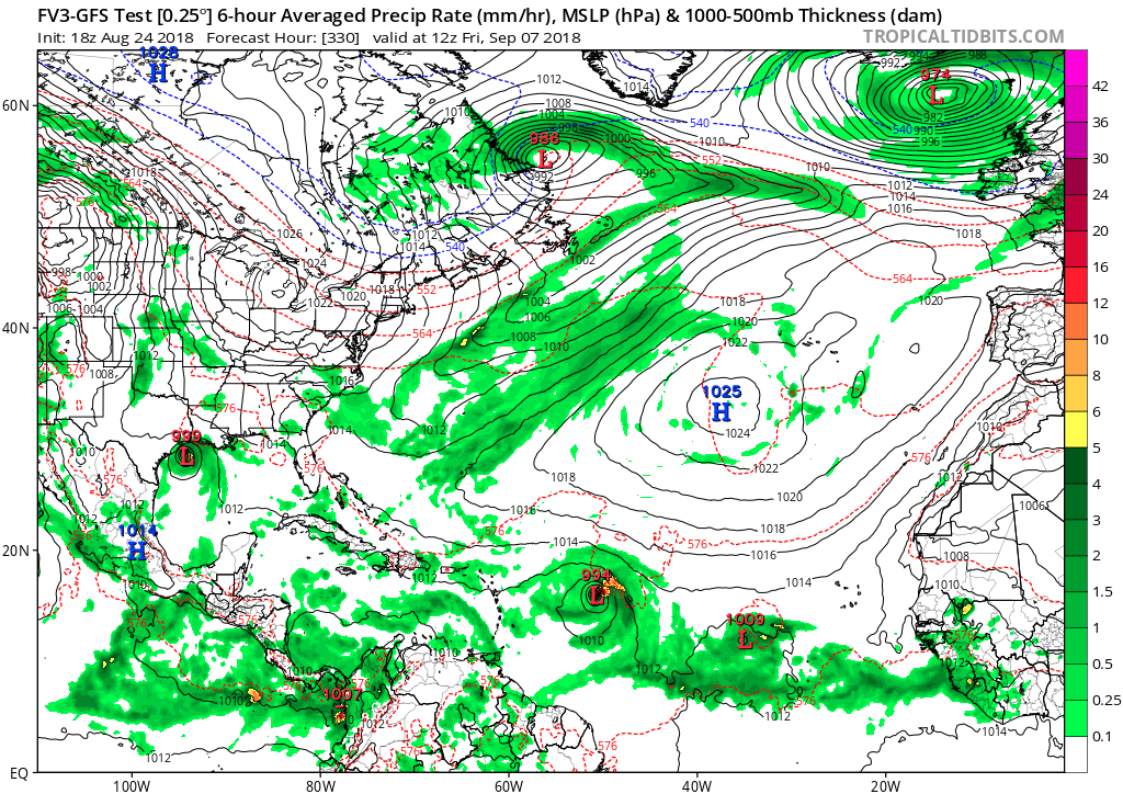
FV3 GFS shows a series of Cape Verde storms, one of them a hurricane, by September 9. Develops the African wave in the GOMEX. We'll need to watch that one closely.
0 likes   
My posts are my own personal opinion, defer to the National Hurricane Center (NHC) and other NOAA products for decision making during hurricane season.

User avatar
gatorcane
S2K Supporter
S2K Supporter
Posts: 23691
Age: 47
Joined: Sun Mar 13, 2005 3:54 pm
Location: Boca Raton, FL

Re: 2018 Tropics: Global Model Runs Discussion (Out to day 16)

#1471 Postby gatorcane » Fri Aug 24, 2018 7:54 pm

Hypercane_Kyle wrote:FV3 GFS shows a series of Cape Verde storms, one of them a hurricane, by September 9. Develops the African wave in the GOMEX. We'll need to watch that one closely.


Active indeed, saved image:

Image
0 likes   

User avatar
cycloneye
Admin
Admin
Posts: 145368
Age: 68
Joined: Thu Oct 10, 2002 10:54 am
Location: San Juan, Puerto Rico

Re: 2018 Tropics: Global Model Runs Discussion (Out to day 16)

#1472 Postby cycloneye » Fri Aug 24, 2018 7:59 pm

Note= Any runs from the models that may show development of wave right now in the Eastern Atlantic can be posted at that thread.

viewtopic.php?f=31&t=119772
2 likes   
Visit the Caribbean-Central America Weather Thread where you can find at first post web cams,radars
and observations from Caribbean basin members Click Here

User avatar
gatorcane
S2K Supporter
S2K Supporter
Posts: 23691
Age: 47
Joined: Sun Mar 13, 2005 3:54 pm
Location: Boca Raton, FL

Re: 2018 Tropics: Global Model Runs Discussion (Out to day 16)

#1473 Postby gatorcane » Sat Aug 25, 2018 7:53 am

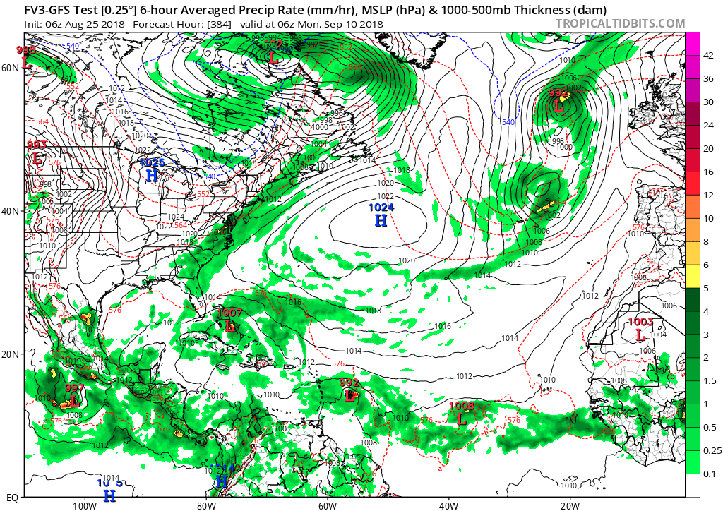
Cape Verde parade of storms at the end of the FV3 GFS run for peak of season:

Image
0 likes   

User avatar
GeneratorPower
S2K Supporter
S2K Supporter
Posts: 1648
Age: 45
Joined: Sun Dec 18, 2005 11:48 pm
Location: Huntsville, AL

Re: 2018 Tropics: Global Model Runs Discussion (Out to day 16)

#1474 Postby GeneratorPower » Sat Aug 25, 2018 8:09 am

Andrew was the “A” storm in 1992. Ironically the same year Iniki struck Hawaii. Models are picking up on typical September.
1 likes   

User avatar
NDG
S2K Supporter
S2K Supporter
Posts: 15446
Joined: Sun Jul 09, 2006 10:14 pm
Location: Orlando, FL

Re: 2018 Tropics: Global Model Runs Discussion (Out to day 16)

#1475 Postby NDG » Sat Aug 25, 2018 8:38 am

With the MJO forecasted to go into phase 1 early next month I would expect for home brew stuff first as the TWs get closer, later in the month is when I would expect the MDR to get active as the MJO moves closer and into phase 2.
1 likes   

User avatar
cycloneye
Admin
Admin
Posts: 145368
Age: 68
Joined: Thu Oct 10, 2002 10:54 am
Location: San Juan, Puerto Rico

Re: 2018 Tropics: Global Model Runs Discussion (Out to day 16)

#1476 Postby cycloneye » Sat Aug 25, 2018 12:19 pm

12z GFS has some flashes of development in MDR but overrall,it has nothing notable thru September 10th.All the developments it has is in EPac.
0 likes   
Visit the Caribbean-Central America Weather Thread where you can find at first post web cams,radars
and observations from Caribbean basin members Click Here

User avatar
Hypercane_Kyle
Category 5
Category 5
Posts: 3352
Joined: Sat Mar 07, 2015 7:58 pm
Location: Cape Canaveral, FL

Re: 2018 Tropics: Global Model Runs Discussion (Out to day 16)

#1477 Postby Hypercane_Kyle » Sat Aug 25, 2018 12:40 pm

cycloneye wrote:12z GFS has some flashes of development in MDR but overrall,it has nothing notable thru September 10th.All the developments it has is in EPac.


On the flip side, the FV3-GFS has a GOMEX storm.
1 likes   
My posts are my own personal opinion, defer to the National Hurricane Center (NHC) and other NOAA products for decision making during hurricane season.

User avatar
Hammy
Category 5
Category 5
Posts: 5849
Age: 41
Joined: Fri May 25, 2012 5:25 pm
Contact:

Re: 2018 Tropics: Global Model Runs Discussion (Out to day 16)

#1478 Postby Hammy » Sat Aug 25, 2018 12:52 pm

cycloneye wrote:12z GFS has some flashes of development in MDR but overrall,it has nothing notable thru September 10th.All the developments it has is in EPac.


That seems like a trend--the favorable conditions that are supposed to arrive just keep getting pushed further and further back and instead EPac activity increases. The CFS essentially shows nothing more than a few strong waves until Sept 12-13 now.
1 likes   
The above post is not official and should not be used as such. It is the opinion of the poster and may or may not be backed by sound meteorological data. It is not endorsed by any professional institution or storm2k.org. For official information, please refer to the NHC and NWS products.

User avatar
toad strangler
S2K Supporter
S2K Supporter
Posts: 4543
Joined: Sun Jul 28, 2013 3:09 pm
Location: Earth
Contact:

Re: 2018 Tropics: Global Model Runs Discussion (Out to day 16)

#1479 Postby toad strangler » Sat Aug 25, 2018 1:51 pm

12z Euro is a Uber yawn fest
1 likes   

User avatar
Hypercane_Kyle
Category 5
Category 5
Posts: 3352
Joined: Sat Mar 07, 2015 7:58 pm
Location: Cape Canaveral, FL

Re: 2018 Tropics: Global Model Runs Discussion (Out to day 16)

#1480 Postby Hypercane_Kyle » Sat Aug 25, 2018 1:58 pm

Pretty much the entire 12z model suite is a big nothing burger... we might go through the first week of September without a single significant storm.
Last edited by Hypercane_Kyle on Sat Aug 25, 2018 2:04 pm, edited 1 time in total.
0 likes   
My posts are my own personal opinion, defer to the National Hurricane Center (NHC) and other NOAA products for decision making during hurricane season.


Return to “Talkin' Tropics”

Who is online

Users browsing this forum: dl20415, Ulf and 56 guests