Forgive me if posted already.
From Meteorologist Larry Cosgrove, 8/24-8/25
8/25:
“Despite a seemingly quiet tropical pattern, the development of 500MB weaknesses and reduced Saharan Air Layer should start to favor more chances for depressions, named storms and hurricanes to threaten the Greater Antilles, Gulf Coast and Eastern Seaboard within the next two weeks or so.
Many of you may have been lulled into thinking that the 2024 hurricane season was over. A rude surprise awaits, however, since the Saharan Air Layer is diminishing, the hemispheric conjoined heat ridge complex is starting to break apart, the ITCZ in Africa is flaring big time, and the polar westerlies are starting to inject cyclonic energy and greater amounts of cooler (not cold) values into lower latitudes. The La Nina episode is likely to top off at just above the moderate designation (-1.0 deg C below normal in ENSO sector 3.4), while the Gulf of Mexico and much of the open Atlantic Ocean is very warm (at least 79 deg F with only minor areas of upwelling. This is not, and never was meant to be, a "Super La Nina with record hurricanes". One-parameter forecasting has no place in a business where fear can cause those living in the subtropical zones and affected coastlines to lose confidence in weather prediction at critical times. I will hold to my original 18 named storms, 10 hurricanes, and 6 major cyclones seasonal call.
We should see a substantial, or more, storm threat in the Gulf Coast in the 11-15 and/or 16-20 day time frame. The ECMWF panels suggest an East Coast event, while the North American ensemble platforms (GFS, GGEM, CFS) series are suggesting Louisiana as a probable danger zone for a tropical cyclone strike. Again, with little shear in a 500MB weakness, very warm sea surface temperatures and added energy from a descending trough and frontal structure, the post-landfall track scenarios could produce very high rainfall rates and severe weather in Dixie, Appalachia and the Northeast in the longer term. The split between the Sonoran and Bermudan heat ridges might allow for a hot West/cool Central/warm, humid East alignment. The analog depictions agree with that scenario for September, and I suspect October will be similar, but with a greater threat zone for a hurricane along the Eastern Seaboard later in the month.”
8/24:
“You will hear, likely over and over, that the Atlantic Basin hurricane season is dead. This is true for the short term, as there are no designated disturbances and the atmosphere between North America and the Old World is largely dry, dusty and hot thanks to the Saharan Air Layer. But the linked, stable heat ridge complex in the subtropical realm from the Pacific Ocean into Iran is showing some cracks, and there will soon be weakness in the ridging that will permit more and heavier moisture advection into the Greater Antilles and North America. Some of the forecast models show threats from tropical features to Texas and the East Coast in the medium range.
The Saharan heat ridge has been linked to the Azores subtropical high for most of July and August, but should start to weaken as we move into September. This lessens the chance for stifling heat outside of the Mediterranean countries, and also will enable ITCZ waves in the equatorial zone of Africa a better chance to intensify and avoid drawing in the very hot and dust-laden air mass across northern Africa. The discontinuity between the SAL and the Kalahari heat ridge is very impressive in terms of tropical waves and moisture, so odds are that the relatively calm period over the Atlantic Basin, major islands and North America will likely be coming to an end soon.”
2024 Global Model Runs Discussion (Out thru day 16)
Moderator: S2k Moderators
Forum rules

The posts in this forum are NOT official forecasts and should not be used as such. They are just the opinion of the poster and may or may not be backed by sound meteorological data. They are NOT endorsed by any professional institution or STORM2K. For official information, please refer to products from the National Hurricane Center and National Weather Service.
Re: 2024 Global Model Runs Discussion (Out thru day 16)
The 3 main 0Z ensemble agree that the highest concentration of members with a TCG is in the MDR 45-60W between 8/31 and 9/3. Overall concentration looks a bit higher vs most earlier runs. This is pretty close to when/where 21 AI-Euro runs in a row had TCG as well as TCGs on recent ICON runs.
The vast majority including myself have the next TCG occurring around then in that poll. We and 21 in a row AI-Euro runs can’t be that wrong, can we/they? I wonder what caused the AI-Euro to suddenly abandon that solution and not come back to it.
Chances for TCG seem pretty good but we’ll see.
The vast majority including myself have the next TCG occurring around then in that poll. We and 21 in a row AI-Euro runs can’t be that wrong, can we/they? I wonder what caused the AI-Euro to suddenly abandon that solution and not come back to it.
Chances for TCG seem pretty good but we’ll see.
1 likes
Personal Forecast Disclaimer:
The posts in this forum are NOT official forecasts and should not be used as such. They are just the opinion of the poster and may or may not be backed by sound meteorological data. They are NOT endorsed by any professional institution or storm2k.org. For official information, please refer to the NHC and NWS products.
The posts in this forum are NOT official forecasts and should not be used as such. They are just the opinion of the poster and may or may not be backed by sound meteorological data. They are NOT endorsed by any professional institution or storm2k.org. For official information, please refer to the NHC and NWS products.

Re: 2024 Global Model Runs Discussion (Out thru day 16)
HurricaneBelle wrote:I just want to see a storm form to end this pointless back-and-forth.
Using this as a jumping off point...
I certainly understand that tropical weather enthusiasts will talk about the tropics, perhaps even more so during a lull in a season they were primed to expect loads of activity. Maybe it's just passing the time, but maybe it uncovers an insight which explains not only what's happening but also what's to come. Understandable, but also valuable and appreciated. It's great there are passionate people researching and learning, thereby lifting us all up through knowledge.
But nonetheless, I can't shake the feeling that much of the present discussion feels premature, like things will make more sense when the full picture comes in to being. I don't thinks that's a banal, stating the obvious thing either – there's still so much story left to unfold. Would any of us be terribly surprised if the basin sparked up ~10 days from now with the models slow to foresee the change? Yet some of the recent talk feels very bearish. I think it was weeniepatrol who recently made the analogy to a bear trap in the stock market. That's an astute observation; we're definitely seeing how psychology and expectation affect perception. In the 16+ day model thread, cycloneye even quoted Eric Webb saying:
That little parenthetical is rather important! This season has not been quiet at all compared to climatological norms, only relative to our cloudy crystal ball. But expectation skews perception and suddenly words like "abnormal" start creeping in. In fairness to Eric he was raising valid questions, but I think labelling this season's start as "abnormally quiet" is powerful, even when paired with a qualification in parentheses. To continue the stock market analogy, I think people are getting worn down and have begun capitulating. In the market, that signals the trap is imminent.Eric Webb (@webberweather on Xwitter) wrote:...this hurricane season's abnormally quiet start thus far through late August (relative to expectations)...".
But critically, weather is not a market trying to grind people down and extract their capital. A tropical bear trap is not necessarily imminent or inevitable and it's possible this season ends up being anomalously inactive. 2013 blew minds, right? Unusual things happen and we don't always understand why when they're happening, let alone in advance. But of course, that works both ways. 2005 and 2020 also blew minds, right? If 2024 impersonates those seasons starting Sept. 5th, we'd end up with 20 storms, 12 hurricanes, and 5-6 majors. Those aren't quite the numbers forecast before the season, but they're extremely close. In fact, TheAustinMan noted in the final stats thread that the average forecast of agencies, universities, and private entities as calculated by the Barcelona Supercomputing Center was 23/12/5.
Who knows what's going to happen from this point forward. There's a lot of energy out there and many indicators point to substantial activity, but this lull does feel strange in the moment and the models remain ambiguous enough to heighten the feeling. How much of that is expectation and how much is real remains to be seen. I'll watch and be patient as the story unfolds. Whatever happens, I think we'll witness something noteworthy.
Anyway, such are my thoughts on this Sunday, August 25th as a hurricane passes less than 200 miles to my south. Stay safe, ya'll! Now back to your regularly scheduled programming, already in progress. =)
Last edited by gib on Mon Aug 26, 2024 10:19 pm, edited 1 time in total.
7 likes
-
Stratton23
- Category 5

- Posts: 3518
- Joined: Fri Jul 21, 2023 10:59 pm
- Location: Katy, Tx
Re: 2024 Global Model Runs Discussion (Out thru day 16)
It looks like the 00z Euro maybe starting to see the monsoon trough breaking down, it has a 2nd wave coming off at a lower latitude ( no development on this run) but maybe a hint at a change?
1 likes

Re: 2024 Global Model Runs Discussion (Out thru day 16)
Stratton23 wrote:It looks like the 00z Euro maybe starting to see the monsoon trough breaking down, it has a 2nd wave coming off at a lower latitude ( no development on this run) but maybe a hint at a change?


Also shows two pretty strong low pressure centers (we haven't seen this yet during the current MDR lull), though one will likely underperform given the latitude, but the one behind it could be the long-tracker the CFS and some ensembles have been hinting at down the road, if these play out. Upper air pattern also looks quite favorable which could keep some of the dry air at bay
2 likes
The above post is not official and should not be used as such. It is the opinion of the poster and may or may not be backed by sound meteorological data. It is not endorsed by any professional institution or storm2k.org. For official information, please refer to the NHC and NWS products.
-
REDHurricane

- Category 1

- Posts: 438
- Age: 28
- Joined: Sun Jul 03, 2022 2:36 pm
- Location: Northeast Pacific Ocean
Re: 2024 Global Model Runs Discussion (Out thru day 16)
Was out of town this weekend so this is the first time I've checked the tropics since Friday night/Saturday morning -- I believed that the Bahamas wave going into the Gulf had a solid chance at doing something with some model support for development just 4-5 days out, but I was somewhat surprised to see that ship has basically already sailed. Here are my thoughts:
1. I still don't trust the models enough to take any forecast more than ~7 days out with anything less than a snowball-sized grain of salt; this has happened too many times before only for there to be a major hurricane storming through the Caribbean in 10 days and so I think it's wise to just take things day-by-day at this point. Deep breaths, everyone.
2. My personal deadline for either A) formation of another NS or B) strong model agreement less than 5 days out that another system is imminent before I begin to even consider the possibility of a "season cancel (relative to expectations, i.e. less than ~175 ACE)" is September 5, 10 days from now -- all three main ensembles currently show at least some signal for development in the general vicinity of the western MDR/far NE Caribbean starting around September 2, so if that wave totally busts then I will start thinking about joining the bear bandwagon along with the rest of you.
3. Even if nothing forms before September 5, I wouldn't be completely shocked (though I obviously wouldn't bet on it) if this season just ends up being heavily backloaded in an unprecedented way and the proverbial switch flips right as everyone stops paying attention around mid-September, 3 weeks behind schedule. Given the never-before-seen conditions in the Atlantic basin right now (primarily the record SST/OHC and extreme northerly WAM position), who's to say that we won't witness something else we've never seen before such as peak season running from mid-September to mid-November this year instead of the usual late-August through late-October? Even though this scenario isn't likely according to our current conception of what a hurricane season looks like, it is by no means impossible and I'm not going to 100% rule it out until November actually comes to pass.
4. Before this September 5 deadline, I personally don't see the point in poring over every successive model run as if there's some great insight to be gained from any of them. No shade at all towards those that do, as this is a forum for weather enthusiasts and it's always productive to discuss these things in detail for future reference if nothing else, but I almost guarantee that we will be no closer to understanding this hurricane season's future by meticulously analyzing each new model run that comes out tomorrow, or the day after that, or even through the next several days. Typically this is the time of year where I'm eagerly awaiting every new model forecast along with everyone else, but since the models are still all over the place with no consistency on a run-to-run basis I am choosing to wait until Thursday/Friday to really start paying attention to them again.
5. The tropics are weird and make no sense sometimes and that's why I love following this stuff... you just never know what's going to happen, and the second you think you do is oftentimes exactly when everything goes sideways. Regardless of whether the rest of this season (or just the next 16 days to stay on topic here) ends up producing absolutely zero activity or breaks the all-time ACE record, I'm super excited to see how it all turns out.
3 likes
-
Blown Away

- S2K Supporter

- Posts: 10253
- Joined: Wed May 26, 2004 6:17 am
Re: 2024 Global Model Runs Discussion (Out thru day 16)
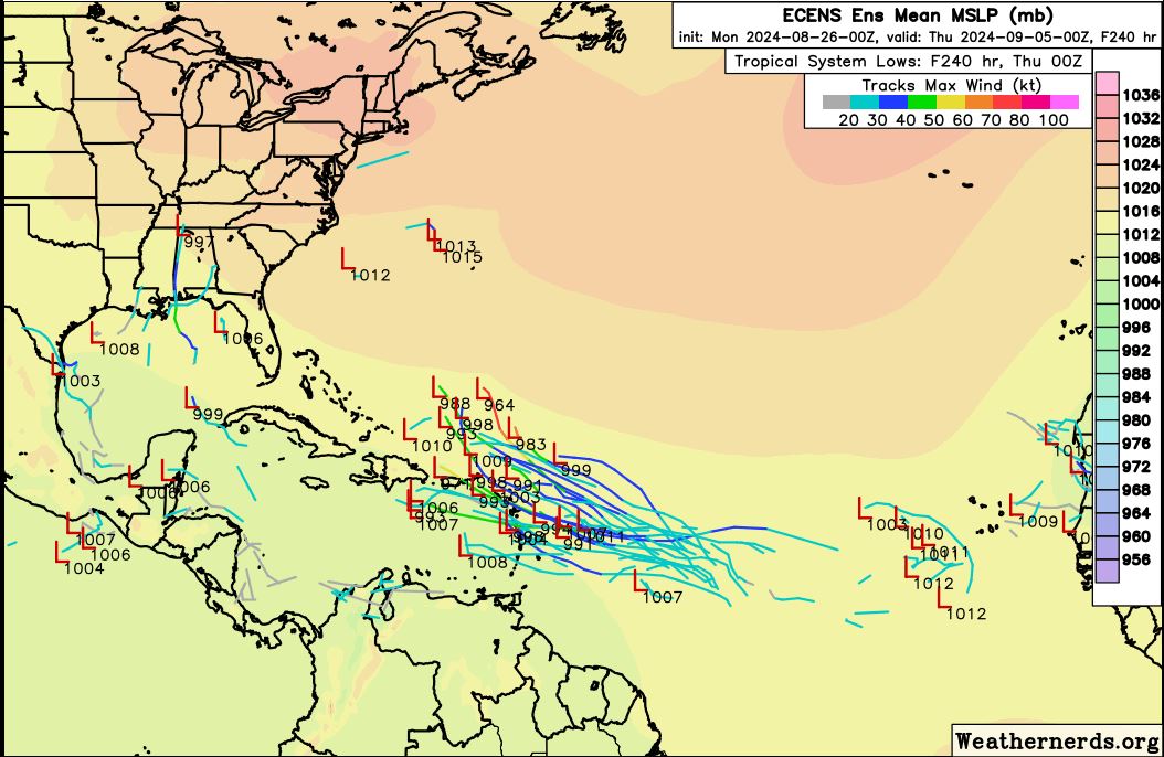
00z ECENS reasonably active, the 00z Euro finished at 240 hours with a weak TW in the E Caribbean...
...
2 likes
Hurricane Eye Experience: David 79, Irene 99, Frances 04, Jeanne 04, Wilma 05… Hurricane Brush Experience: Andrew 92, Erin 95, Floyd 99, Matthew 16, Irma 17, Ian 22, Nicole 22…
-
MEANINGLESS_NUMBERS
- Category 2

- Posts: 503
- Joined: Mon Nov 02, 2020 1:43 pm
Re: 2024 Global Model Runs Discussion (Out thru day 16)
Peak of the season is September 10th. GFS still shows nothing through September 10th. The ensembles have a little action, but it is in their nature to always show something from the members that were granted a more favorable starting position. It really is impressive how little we are seeing at the absolute peak of the season.
0 likes
Emily '87, Felix '95, Gert '99, Fabian '03, Humberto '19, Paulette '20, Teddy '20, Fiona '22, Lee '23, Ernesto '24, Humberto/Imelda '25
-
WaveBreaking

- Category 2
- Posts: 717
- Joined: Sun Jun 30, 2024 11:33 am
- Location: US
Re: 2024 Global Model Runs Discussion (Out thru day 16)
Uptrend in members in 06z GEFS run. Tracks are also more concentrated than last run (not paying attention to track direction since it’s ~10 days out).


1 likes
I am NOT a professional meteorologist, so take all of my posts with a grain of salt. My opinions are mine and mine alone.

Re: 2024 Global Model Runs Discussion (Out thru day 16)
MEANINGLESS_NUMBERS wrote:Peak of the season is September 10th. GFS still shows nothing through September 10th. The ensembles have a little action, but it is in their nature to always show something from the members that were granted a more favorable starting position. It really is impressive how little we are seeing at the absolute peak of the season.
I won’t argue that seeing nothing on the op runs through early Sept isn’t jarring, but nothing makes the operational run solution any more likely than an individual ensemble member. And we’re not just talking about random noise here. There is a strong, concentrated signal for MDR development on the ensembles.
2 likes
Kendall -> SLO -> PBC
Memorable Storms: Katrina (for its Florida landfall...) Wilma Matthew Irma
Memorable Storms: Katrina (for its Florida landfall...) Wilma Matthew Irma
-
Blown Away
- S2K Supporter
- Posts: 10253
- Joined: Wed May 26, 2004 6:17 am
Re: 2024 Global Model Runs Discussion (Out thru day 16)
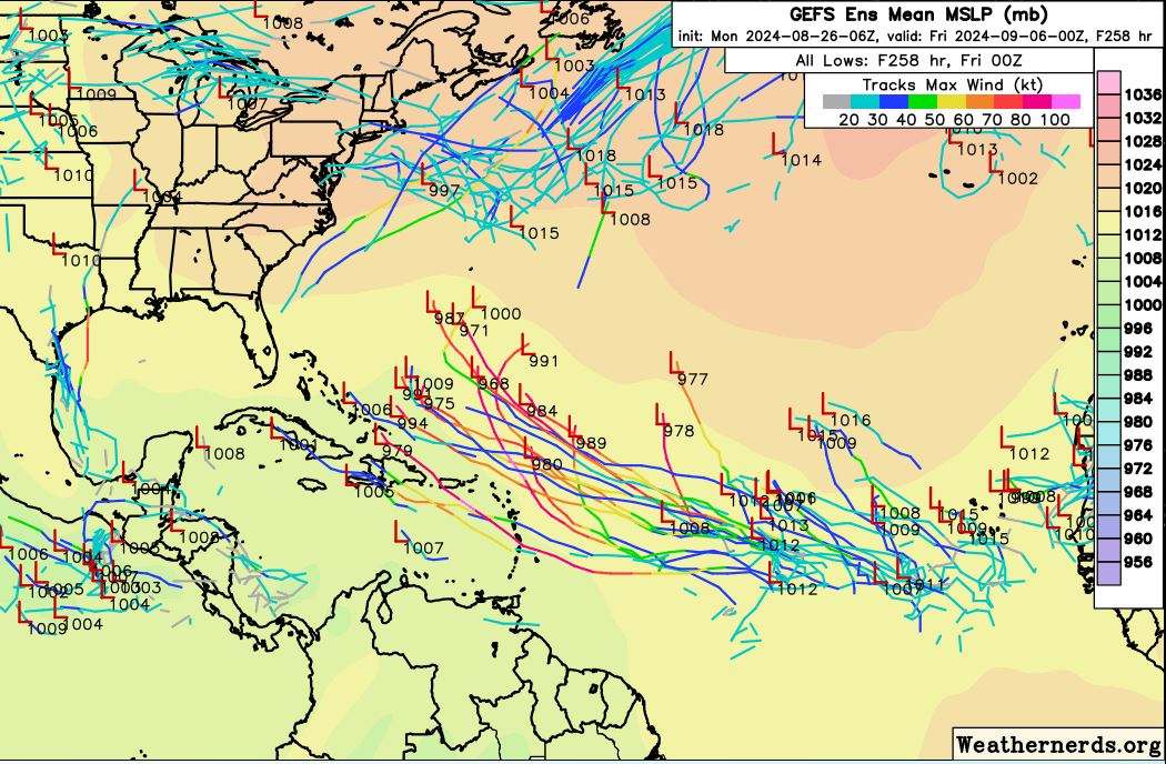
06 GEFS lighting up!!!!
1 likes
Hurricane Eye Experience: David 79, Irene 99, Frances 04, Jeanne 04, Wilma 05… Hurricane Brush Experience: Andrew 92, Erin 95, Floyd 99, Matthew 16, Irma 17, Ian 22, Nicole 22…
-
Hypercane_Kyle

- Category 5
- Posts: 3465
- Joined: Sat Mar 07, 2015 7:58 pm
- Location: Cape Canaveral, FL
Re: 2024 Global Model Runs Discussion (Out thru day 16)
Modest EPS support, as well.
0 likes
My posts are my own personal opinion, defer to the National Hurricane Center (NHC) and other NOAA products for decision making during hurricane season.
-
jlauderdal
- S2K Supporter
- Posts: 7240
- Joined: Wed May 19, 2004 5:46 am
- Location: NE Fort Lauderdale
- Contact:
Re: 2024 Global Model Runs Discussion (Out thru day 16)
WaveBreaking wrote:Uptrend in members in 06z GEFS run. Tracks are also more concentrated than last run (not paying attention to track direction since it’s ~10 days out).
https://i.imgur.com/CsfemOY.png
https://i.imgur.com/A9cQ5zC.png
It will need to look that way until November for CSU to hit their number.
0 likes

Re: 2024 Global Model Runs Discussion (Out thru day 16)
It certainly looks like with respect to the ensembles, the switch flipped at 0z last night.
Here are my counts of the number of ensemble members showing at least a low pressure center from the central MDR wave alone (most of them have 30 kt winds):
People were saying earlier that ensemble signals from day 10+ weren't moving into the day 7-10 range... Well, now we've gone way better than that. On 6z GEFS, most of the lows started appearing within 4-5 days (8/30-31). Day 7 has a very healthy signal, with all 19 members mentioned above already having a TS and a couple of hurricanes.
Additionally, 0z and 6z GEFS both hint at development of another wave further east near the CV islands, either during the same time frame or just a few days later.
Here are my counts of the number of ensemble members showing at least a low pressure center from the central MDR wave alone (most of them have 30 kt winds):
- 0z GEFS: 16 members (52%)
- 6z GEFS: 19 members (62%)
- 0z EPS: 24 members (48%)
People were saying earlier that ensemble signals from day 10+ weren't moving into the day 7-10 range... Well, now we've gone way better than that. On 6z GEFS, most of the lows started appearing within 4-5 days (8/30-31). Day 7 has a very healthy signal, with all 19 members mentioned above already having a TS and a couple of hurricanes.
Additionally, 0z and 6z GEFS both hint at development of another wave further east near the CV islands, either during the same time frame or just a few days later.
3 likes
TC naming lists: retirements and intensity
Most aggressive Advisory #1's in North Atlantic (cr. kevin for starting the list)
Most aggressive Advisory #1's in North Atlantic (cr. kevin for starting the list)
Re: 2024 Global Model Runs Discussion (Out thru day 16)
jlauderdal wrote:WaveBreaking wrote:Uptrend in members in 06z GEFS run. Tracks are also more concentrated than last run (not paying attention to track direction since it’s ~10 days out).
https://i.imgur.com/CsfemOY.png
https://i.imgur.com/A9cQ5zC.png
It will need to look that way until November for CSU to hit their number.
Even then, that's quite a change from just 24 hours ago when even many pro mets and meteorologists were implying that nothing would form in the next 1-2 weeks.
1 likes
TC naming lists: retirements and intensity
Most aggressive Advisory #1's in North Atlantic (cr. kevin for starting the list)
Most aggressive Advisory #1's in North Atlantic (cr. kevin for starting the list)
-
jlauderdal
- S2K Supporter
- Posts: 7240
- Joined: Wed May 19, 2004 5:46 am
- Location: NE Fort Lauderdale
- Contact:
Re: 2024 Global Model Runs Discussion (Out thru day 16)
Jr0d wrote:I am willing to bet that by Labor Day weekend(August 31st) that somewhere in the CONUS will be either in an orange potential development cone or in the cone of uncertainty from a classified system.
If I am wrong I will give Storm2k $10...if anyone takes me up on the bet and I am right, they will donate $10...
Any takers?
How are we looking?
0 likes
-
jlauderdal
- S2K Supporter
- Posts: 7240
- Joined: Wed May 19, 2004 5:46 am
- Location: NE Fort Lauderdale
- Contact:
Re: 2024 Global Model Runs Discussion (Out thru day 16)
Teban54 wrote:jlauderdal wrote:WaveBreaking wrote:Uptrend in members in 06z GEFS run. Tracks are also more concentrated than last run (not paying attention to track direction since it’s ~10 days out).
https://i.imgur.com/CsfemOY.png
https://i.imgur.com/A9cQ5zC.png
It will need to look that way until November for CSU to hit their number.
Even then, that's quite a change from just 24 hours ago when even many pro mets and meteorologists were implying that nothing would form in the next 1-2 weeks.
Anyone going out beyond 240H at the peak of hurricane season and declaring nada is making a big mistake.
1 likes
Re: 2024 Global Model Runs Discussion (Out thru day 16)
caneman wrote:Forgive me if posted already.
From Meteorologist Larry Cosgrove, 8/24-8/25
8/25:
“Despite a seemingly quiet tropical pattern, the development of 500MB weaknesses and reduced Saharan Air Layer should start to favor more chances for depressions, named storms and hurricanes to threaten the Greater Antilles, Gulf Coast and Eastern Seaboard within the next two weeks or so.
Many of you may have been lulled into thinking that the 2024 hurricane season was over. A rude surprise awaits, however, since the Saharan Air Layer is diminishing, the hemispheric conjoined heat ridge complex is starting to break apart, the ITCZ in Africa is flaring big time, and the polar westerlies are starting to inject cyclonic energy and greater amounts of cooler (not cold) values into lower latitudes. The La Nina episode is likely to top off at just above the moderate designation (-1.0 deg C below normal in ENSO sector 3.4), while the Gulf of Mexico and much of the open Atlantic Ocean is very warm (at least 79 deg F with only minor areas of upwelling. This is not, and never was meant to be, a "Super La Nina with record hurricanes". One-parameter forecasting has no place in a business where fear can cause those living in the subtropical zones and affected coastlines to lose confidence in weather prediction at critical times. I will hold to my original 18 named storms, 10 hurricanes, and 6 major cyclones seasonal call.
We should see a substantial, or more, storm threat in the Gulf Coast in the 11-15 and/or 16-20 day time frame. The ECMWF panels suggest an East Coast event, while the North American ensemble platforms (GFS, GGEM, CFS) series are suggesting Louisiana as a probable danger zone for a tropical cyclone strike. Again, with little shear in a 500MB weakness, very warm sea surface temperatures and added energy from a descending trough and frontal structure, the post-landfall track scenarios could produce very high rainfall rates and severe weather in Dixie, Appalachia and the Northeast in the longer term. The split between the Sonoran and Bermudan heat ridges might allow for a hot West/cool Central/warm, humid East alignment. The analog depictions agree with that scenario for September, and I suspect October will be similar, but with a greater threat zone for a hurricane along the Eastern Seaboard later in the month.”
8/24:
“You will hear, likely over and over, that the Atlantic Basin hurricane season is dead. This is true for the short term, as there are no designated disturbances and the atmosphere between North America and the Old World is largely dry, dusty and hot thanks to the Saharan Air Layer. But the linked, stable heat ridge complex in the subtropical realm from the Pacific Ocean into Iran is showing some cracks, and there will soon be weakness in the ridging that will permit more and heavier moisture advection into the Greater Antilles and North America. Some of the forecast models show threats from tropical features to Texas and the East Coast in the medium range.
The Saharan heat ridge has been linked to the Azores subtropical high for most of July and August, but should start to weaken as we move into September. This lessens the chance for stifling heat outside of the Mediterranean countries, and also will enable ITCZ waves in the equatorial zone of Africa a better chance to intensify and avoid drawing in the very hot and dust-laden air mass across northern Africa. The discontinuity between the SAL and the Kalahari heat ridge is very impressive in terms of tropical waves and moisture, so odds are that the relatively calm period over the Atlantic Basin, major islands and North America will likely be coming to an end soon.”
I have always respected LC. Back in 1996 when he was a TV Met in Philadelphia he was te first to sniff out the 30 inch blizzard of 1996 which is still to this day the biggest snowstorm in Phila history. He sniffed it out a full week in advance with 1996 technokogy.
0 likes
-
Category5Kaiju

- Category 5
- Posts: 4330
- Joined: Thu Dec 24, 2020 12:45 pm
- Location: Seattle and Phoenix
Re: 2024 Global Model Runs Discussion (Out thru day 16)
And look at that....ensembles have seemed to really uptick regarding that central/western MDR disturbance next week. Also subtle hints of perhaps something getting going near the Cape Verde islands a bit after that.
I'm going to say this as respectfully and firmly as possible, but PEOPLE. NEED. TO. BE. PATIENT.
I'm going to say this as respectfully and firmly as possible, but PEOPLE. NEED. TO. BE. PATIENT.
6 likes
Unless explicitly stated, all info in my posts is based on my own opinions and observations. Tropical storms and hurricanes can be extremely dangerous. Refer to an accredited weather research agency or meteorologist if you need to make serious decisions regarding an approaching storm.
Re: 2024 Global Model Runs Discussion (Out thru day 16)
When flhurruicane said ghosts of 2013 in this case I think meant the fact there's not a good explanation (that I can find) where late August was this dead. September may change, but I recall 2013 also being a year where the seasonal experts were kind of at a loss to explain the lack of activity (which seemed to all go to the Central Pacific and Hawaii). I do think September will change, but I doubt the high end seasonal forecasts now. (It'll probably be still high, just not as high, and just Delayed until mid September) The Ensembles currently are showing it starting to kick off around or just after labor day.
0 likes
Who is online
Users browsing this forum: gib and 202 guests