https://twitter.com/yconsor/status/1544750695286554626
2022 Indicators (SSTs/SAL/MSLP/Shear/Steering/Instability) and >Day 16 Models
Moderator: S2k Moderators
Forum rules

The posts in this forum are NOT official forecasts and should not be used as such. They are just the opinion of the poster and may or may not be backed by sound meteorological data. They are NOT endorsed by any professional institution or STORM2K. For official information, please refer to products from the National Hurricane Center and National Weather Service.
-
SFLcane

- S2K Supporter

- Posts: 10281
- Age: 48
- Joined: Sat Jun 05, 2010 1:44 pm
- Location: Lake Worth Florida
Re: 2022 Indicators (SSTs/SAL/MSLP/Shear/Steering/Instability) and >Day 16 Models
Great 500 mb height anomaly steering thread by Yaakov Cantor on twitter. Encourage all to take a look
@yconsor
@yconsor
1 likes
-
Category5Kaiju

- Category 5

- Posts: 4346
- Joined: Thu Dec 24, 2020 12:45 pm
- Location: Seattle during the summer, Phoenix during the winter
Re: 2022 Indicators (SSTs/SAL/MSLP/Shear/Steering/Instability) and >Day 16 Models
Yeah, typically speaking, it seems like September storms like Irma, Florence, and Georges that are Cape Verde storms and go on to do a lot of damage in the CONUS especially aren't all that common. Climatologically speaking, seem to me that August that typically features a higher risk of Cape Verde systems actually tracking and hitting land than September.
Now of course, I generally wouldn't conclude that this means we're off the hook for September, because steering patterns are very dynamic, and in a given year one would expect some storms to go out to sea and others to hit land. Years like 2010 that are very active but also relatively tame for land aren't exactly the norm
0 likes
Unless explicitly stated, all information in my posts is based on my own opinions and observations. Tropical storms and hurricanes can be extremely dangerous. Refer to an accredited weather research agency or meteorologist if you need to make serious decisions regarding an approaching storm.

-
toad strangler

- S2K Supporter
- Posts: 4546
- Joined: Sun Jul 28, 2013 3:09 pm
- Location: Earth
- Contact:
Re: 2022 Indicators (SSTs/SAL/MSLP/Shear/Steering/Instability) and >Day 16 Models
USTropics wrote:https://twitter.com/WorldClimateSvc/status/1544768156752912384
The analog year search is a noble endeavor given the fact that no one season is truly the same. Overall activity can be somewhat confidently forecasted based upon them. I just don’t think they mean a hill of beans when it comes to storm tracks.
1 likes
My Weather Station
https://www.wunderground.com/dashboard/pws/KFLPORTS603
https://www.wunderground.com/dashboard/pws/KFLPORTS603
-
skyline385

- Category 5
- Posts: 2728
- Age: 35
- Joined: Wed Aug 26, 2020 11:15 pm
- Location: Houston TX
-
Category5Kaiju
- Category 5
- Posts: 4346
- Joined: Thu Dec 24, 2020 12:45 pm
- Location: Seattle during the summer, Phoenix during the winter
Re: 2022 Indicators (SSTs/SAL/MSLP/Shear/Steering/Instability) and >Day 16 Models
https://twitter.com/dmorris9661/status/1544849613810720768
Just look at how many reached major hurricane strength, let alone Category 4 status or higher.
Just look at how many reached major hurricane strength, let alone Category 4 status or higher.
0 likes
Unless explicitly stated, all information in my posts is based on my own opinions and observations. Tropical storms and hurricanes can be extremely dangerous. Refer to an accredited weather research agency or meteorologist if you need to make serious decisions regarding an approaching storm.
-
skyline385
- Category 5
- Posts: 2728
- Age: 35
- Joined: Wed Aug 26, 2020 11:15 pm
- Location: Houston TX
2022 Indicators (SSTs/SAL/MSLP/Shear/Steering/Instability) and >Day 16 Models
Latest EPS seems to be suggesting potential for some activity around mid July now with rising air over Indian Ocean and Africa but no suppressed phase over the NATL, however still nothing popping up on the members.

0 likes

Re: 2022 Indicators (SSTs/SAL/MSLP/Shear/Steering/Instability) and >Day 16 Models
skyline385 wrote:Latest EPS seems to be suggesting potential for some activity around mid July now with rising air over Indian Ocean and Africa but no suppressed phase over the NATL, however still nothing popping up on the members.
https://uploads.tapatalk-cdn.com/20220707/e431b73be8bdd771882b5fbd2329328f.jpg
That’s still over 300 hours out. The ensembles probably won’t begin to pick up on any less suppressed or possibly enhanced phase for another several days
0 likes
Irene '11 Sandy '12 Hermine '16 5/15/2018 Derecho Fay '20 Isaias '20 Elsa '21 Henri '21 Ida '21
I am only a meteorology enthusiast who knows a decent amount about tropical cyclones. Look to the professional mets, the NHC, or your local weather office for the best information.
I am only a meteorology enthusiast who knows a decent amount about tropical cyclones. Look to the professional mets, the NHC, or your local weather office for the best information.
-
SFLcane
- S2K Supporter
- Posts: 10281
- Age: 48
- Joined: Sat Jun 05, 2010 1:44 pm
- Location: Lake Worth Florida
Re: 2022 Indicators (SSTs/SAL/MSLP/Shear/Steering/Instability) and >Day 16 Models
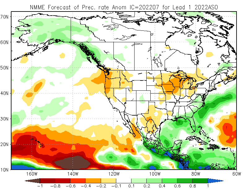
Wxman57 your call of threats to the NE gulf, Florida , and the caribbean are valid it appears on the NMME.
0 likes
Re: 2022 Indicators (SSTs/SAL/MSLP/Shear/Steering/Instability) and >Day 16 Models
SFLcane wrote:Buckle up!!
https://twitter.com/dmorris9661/status/1545038512193282049?s=20&t=0Pq-e-e0U1yGV-vUwo8bNw
And yet, all is quiet for now. I was looking at the Atlantic satellite, there's a wave almost in the central Atlantic, is there anything you foresee happening with it?
0 likes
-
SFLcane
- S2K Supporter
- Posts: 10281
- Age: 48
- Joined: Sat Jun 05, 2010 1:44 pm
- Location: Lake Worth Florida
Re: 2022 Indicators (SSTs/SAL/MSLP/Shear/Steering/Instability) and >Day 16 Models
underthwx wrote:SFLcane wrote:Buckle up!!
https://twitter.com/dmorris9661/status/1545038512193282049?s=20&t=0Pq-e-e0U1yGV-vUwo8bNw
And yet, all is quiet for now. I was looking at the Atlantic satellite, there's a wave almost in the central Atlantic, is there anything you foresee happening with it?
No development is highly unlikely most of july maybe end of the month.
0 likes
-
cycloneye

- Admin

- Posts: 149719
- Age: 69
- Joined: Thu Oct 10, 2002 10:54 am
- Location: San Juan, Puerto Rico
Re: 2022 Indicators (SSTs/SAL/MSLP/Shear/Steering/Instability) and >Day 16 Models (NMME July forecast is up)
3 likes
Visit the Caribbean-Central America Weather Thread where you can find at first post web cams,radars
and observations from Caribbean basin members Click Here
and observations from Caribbean basin members Click Here
-
Category5Kaiju
- Category 5
- Posts: 4346
- Joined: Thu Dec 24, 2020 12:45 pm
- Location: Seattle during the summer, Phoenix during the winter
Re: 2022 Indicators (SSTs/SAL/MSLP/Shear/Steering/Instability) and >Day 16 Models (NMME July forecast is up)
Imho, this seems to be looking like perhaps among the most active Caribbean years we've had in recent times. Maybe more quality, longer-lived major hurricanes there compared to a year like 2020? Only time will tell, but I personally wouldn't be shocked to see something like that happen, let alone a cruiser.
1 likes
Unless explicitly stated, all information in my posts is based on my own opinions and observations. Tropical storms and hurricanes can be extremely dangerous. Refer to an accredited weather research agency or meteorologist if you need to make serious decisions regarding an approaching storm.
-
hurricane2025
- Category 1

- Posts: 254
- Joined: Thu Apr 08, 2021 10:36 am

Re: 2022 Indicators (SSTs/SAL/MSLP/Shear/Steering/Instability) and >Day 16 Models
SFLcane wrote:Wxman57 your call of threats to the NE gulf, Florida , and the caribbean are valid it appears on the NMME.
https://i.postimg.cc/cHwx5QcV/nmme.png
I think his thoughts were based on the persistent and downright hellish death ridge that has been over us in Texas for months now. Of course, patterns can change, but it has definitely been in place for at least two months now, with little signs of budging.
0 likes
Personal Forecast Disclaimer:
The posts in this forum are NOT official forecast and should not be used as such. They are just the opinion of the poster and may or may not be backed by sound meteorological data. They are NOT endorsed by any professional institution or storm2k.org. For official information, please refer to the NHC and NWS products.
The posts in this forum are NOT official forecast and should not be used as such. They are just the opinion of the poster and may or may not be backed by sound meteorological data. They are NOT endorsed by any professional institution or storm2k.org. For official information, please refer to the NHC and NWS products.
-
SFLcane
- S2K Supporter
- Posts: 10281
- Age: 48
- Joined: Sat Jun 05, 2010 1:44 pm
- Location: Lake Worth Florida
Re: 2022 Indicators (SSTs/SAL/MSLP/Shear/Steering/Instability) and >Day 16 Models (NMME July forecast is up)
Luis....
Caribbean-Florida connection? The entire Florida peninsula is wet on this new NMME .
Caribbean-Florida connection? The entire Florida peninsula is wet on this new NMME .
1 likes

Re: 2022 Indicators (SSTs/SAL/MSLP/Shear/Steering/Instability) and >Day 16 Models
SoupBone wrote:SFLcane wrote:Wxman57 your call of threats to the NE gulf, Florida , and the caribbean are valid it appears on the NMME.
https://i.postimg.cc/cHwx5QcV/nmme.png
I think his thoughts were based on the persistent and downright hellish death ridge that has been over us in Texas for months now. Of course, patterns can change, but it has definitely been in place for at least two months now, with little signs of budging.
The Euro forecast was showing a favorable look for the NW Gulf a couple days ago for tc activity but the NMME is showing a more favorable look towards the eastern Gulf it appears to me.
2 likes
Who is online
Users browsing this forum: No registered users and 135 guests