Early June Development in WCarib or BOC? (Is Invest 91L)
Moderator: S2k Moderators
Forum rules

The posts in this forum are NOT official forecasts and should not be used as such. They are just the opinion of the poster and may or may not be backed by sound meteorological data. They are NOT endorsed by any professional institution or STORM2K. For official information, please refer to products from the National Hurricane Center and National Weather Service.
-
Dean4Storms
- S2K Supporter

- Posts: 6358
- Age: 63
- Joined: Sun Aug 31, 2003 1:01 pm
- Location: Miramar Bch. FL
-
Aric Dunn
- Category 5

- Posts: 21238
- Age: 43
- Joined: Sun Sep 19, 2004 9:58 pm
- Location: Ready for the Chase.
- Contact:
The moisture and convection on the increase in a big way today with a wave also approaching from the eastern carrib the timing appears to be in line with the models.,
however the models keep the energy near or over land... maybe hard to get anything going..
however the models keep the energy near or over land... maybe hard to get anything going..
0 likes
Note: If I make a post that is brief. Please refer back to previous posts for the analysis or reasoning. I do not re-write/qoute what my initial post said each time.
If there is nothing before... then just ask
Space & Atmospheric Physicist, Embry-Riddle Aeronautical University,
I believe the sky is falling...
If there is nothing before... then just ask
Space & Atmospheric Physicist, Embry-Riddle Aeronautical University,
I believe the sky is falling...
-
Hurricaneman

- Category 5
- Posts: 7404
- Age: 45
- Joined: Tue Aug 31, 2004 3:24 pm
- Location: central florida
Re: Early June Development in Western Caribbean?
The 18zGFS shows the monsoon trough around 90hrs becoming a broad low from about 96 to 216 consolidating at 216 into a tropical cyclone so the model shows this thing taking 5 days to go from broad low to tropical cyclone which for the type of tropical system would make perfect sense so the BOC and Western Caribbean need to be watched for possible action later in the week
0 likes

Re: Early June Development in Western Caribbean?
Moisture on the increase in the caribbean this morning. The 00z ECM and GFS are now aligning at the 10 day time frame with weak low development off the NE Yucatan. If something does develop, I'd expect the typical weak sheared tropical storm but it could be a huge rain maker especially for the FL peninsula.
http://www.ssd.noaa.gov/goes/east/watl/flash-avn.html
http://www.ssd.noaa.gov/goes/east/watl/flash-avn.html
0 likes
-
Hurricaneman
- Category 5
- Posts: 7404
- Age: 45
- Joined: Tue Aug 31, 2004 3:24 pm
- Location: central florida
Re: Early June Development in Western Caribbean?
The models the last couple of days especially the GFS are showing landfall anywhere between Pensacola to Naples so if this does or doesn't form it will be a real wet late next week for Florida, possibly even early the week after
0 likes

Re: Early June Development in Western Caribbean?
One thing for sure is that both the GFS and Euro show a very wet pattern for the FL Peninsula over the next 10 days, especially for southern FL where the GFS has been persistently showing rainfall totals in the 5-10" range.
0 likes
-
tolakram
- Admin

- Posts: 20185
- Age: 62
- Joined: Sun Aug 27, 2006 8:23 pm
- Location: Florence, KY (name is Mark)
Re: Early June Development in Western Caribbean?
I use this model page: http://moe.met.fsu.edu/tcgengifs/
Until something shows up before the very last frames I don't believe it, and even then I think it's a stretch.
Right now, in the last frames, GFS and Euro showing something, maybe, in the southern Gulf. My guess is something related to an EPAC storm and won't really be an issue.
The Canadian, again in the last few frames, shows something in the NE Gulf, hitting the Panhandle.
I hate to be the old grumpy one, but right now no reliable model is showing anything in the Western Caribbean.
The posts in this forum are NOT official forecast and should not be used as such. They are just the opinion of the poster and may or may not be backed by sound meteorological data. They are NOT endorsed by any professional institution or storm2k.org. For official information, please refer to the NHC and NWS products.
0 likes
M a r k
- - - - -
Join us in chat: Storm2K Chatroom Invite. Android and IOS apps also available.
The posts in this forum are NOT official forecasts and should not be used as such. Posts are NOT endorsed by any professional institution or STORM2K.org. For official information and forecasts, please refer to NHC and NWS products.
-
cycloneye

- Admin
- Posts: 149473
- Age: 69
- Joined: Thu Oct 10, 2002 10:54 am
- Location: San Juan, Puerto Rico
Re: Early June Development in Western Caribbean?
Here is the latest discussion about this by Rob of Crownweather.
http://www.crownweather.com/?p=7363
http://www.crownweather.com/?p=7363
0 likes
Visit the Caribbean-Central America Weather Thread where you can find at first post web cams,radars
and observations from Caribbean basin members Click Here
and observations from Caribbean basin members Click Here

Re: Early June Development in Western Caribbean?
Watch the long water vapor loop, there is dry Texas air retrograding east across the Gulf of Mexico this week. Probably some energy from the Pacific will cross next week somewhere. Could fire up off Belize or even as far south as Panama, S Florida has the higher probability of being effected IMOATT.
0 likes
-
Dean4Storms
- S2K Supporter
- Posts: 6358
- Age: 63
- Joined: Sun Aug 31, 2003 1:01 pm
- Location: Miramar Bch. FL
Re: Early June Development in Western Caribbean?
0 likes
-
Hurricaneman
- Category 5
- Posts: 7404
- Age: 45
- Joined: Tue Aug 31, 2004 3:24 pm
- Location: central florida
Re:
Dean4Storms wrote:Both GFS and ECM 12z are focusing the energy moreso in the BOC then driving it NE. ECM has a developing Low 1005mb north of the Yucatan @ 240hr. Also showing an east coast ridge extending from the Carolina's down across north Florida, could help in a baroclinic driven Low to take shape.
I'm thinking more along the lines of a typical June Tropical storm, wet and windy on the east side while the west side is dry or has lighter precipitation due to drier air coming into the gulf with the trough
0 likes
-
Aric Dunn
- Category 5
- Posts: 21238
- Age: 43
- Joined: Sun Sep 19, 2004 9:58 pm
- Location: Ready for the Chase.
- Contact:
The cmc solution with something developing off the se coast of fl maybe a possibility.. though low. the convection being enhanced by upper divergence and already a weak mid lvl rotation off miami. not likely but not out of the realm..
also you all notice the nhc track for td2 in epac.. that could be out first system if it can hold together and reform in the boc.
also you all notice the nhc track for td2 in epac.. that could be out first system if it can hold together and reform in the boc.
0 likes
Note: If I make a post that is brief. Please refer back to previous posts for the analysis or reasoning. I do not re-write/qoute what my initial post said each time.
If there is nothing before... then just ask
Space & Atmospheric Physicist, Embry-Riddle Aeronautical University,
I believe the sky is falling...
If there is nothing before... then just ask
Space & Atmospheric Physicist, Embry-Riddle Aeronautical University,
I believe the sky is falling...

Re: Early June Development in Western Caribbean?
Today's 12Z GFS shows development starting in the BOC at 120 hrs. Perhaps from newly named TD TWO-E crossing over from the E Pac?

0 likes
-
SouthDadeFish

- Professional-Met

- Posts: 2835
- Joined: Thu Sep 23, 2010 2:54 pm
- Location: Miami, FL
- Contact:

-
Hurricaneman
- Category 5
- Posts: 7404
- Age: 45
- Joined: Tue Aug 31, 2004 3:24 pm
- Location: central florida
Re: Early June Development in Western Caribbean or BOC?
Is it possible if it makes it to the BOC without discontinuation of advisories that this may still be Barbara if it reorganizes and hits somewhere in the Gulf making Andrea not be used until a later system
0 likes
-
Aric Dunn
- Category 5
- Posts: 21238
- Age: 43
- Joined: Sun Sep 19, 2004 9:58 pm
- Location: Ready for the Chase.
- Contact:
Re: Early June Development in Western Caribbean or BOC?
Hurricaneman wrote:Is it possible if it makes it to the BOC without discontinuation of advisories that this may still be Barbara if it reorganizes and hits somewhere in the Gulf making Andrea not be used until a later system
no it would be renamed.
0 likes
Note: If I make a post that is brief. Please refer back to previous posts for the analysis or reasoning. I do not re-write/qoute what my initial post said each time.
If there is nothing before... then just ask
Space & Atmospheric Physicist, Embry-Riddle Aeronautical University,
I believe the sky is falling...
If there is nothing before... then just ask
Space & Atmospheric Physicist, Embry-Riddle Aeronautical University,
I believe the sky is falling...
-
cycloneye
- Admin
- Posts: 149473
- Age: 69
- Joined: Thu Oct 10, 2002 10:54 am
- Location: San Juan, Puerto Rico
Re:
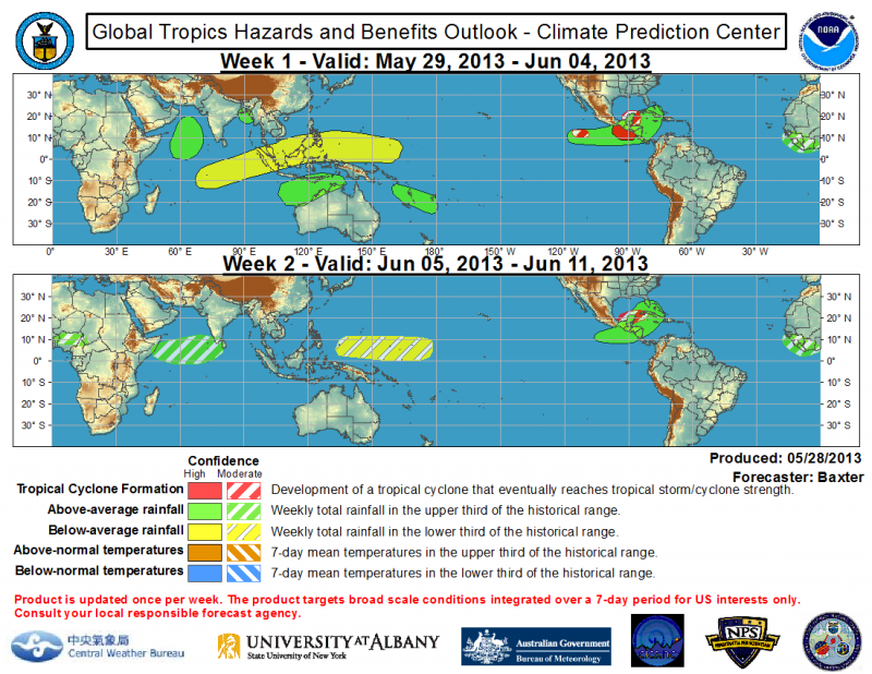
NDG wrote:CPC's latest outlook for the tropics:
http://i20.photobucket.com/albums/b245/ ... e267d7.png
Here is the text from them.
http://www.cpc.ncep.noaa.gov/products/p ... /ghazards/
The Week-2 outlook is based largely on the expectation of a renewed organization of the MJO with its enhanced phase centered across Africa propagating eastward into the Indian Ocean. Low frequency variability and model guidance are also used to create the outlook. Above-average (below-average) rainfall is favored across much of the western Indian Ocean (western Pacific) due to the forecast MJO phase. Uncertainty with respect to the MJO leads to reduced confidence in these areas. Wetter-than-average conditions are also favored across parts of western and central Africa based largely on MJO composites. The Caribbean is forecast to remain active into Week-2, with the threat of TC development lingering near the Yucatan Peninsula
0 likes
Visit the Caribbean-Central America Weather Thread where you can find at first post web cams,radars
and observations from Caribbean basin members Click Here
and observations from Caribbean basin members Click Here
Who is online
Users browsing this forum: No registered users and 205 guests