We gonna be in a LOT of trouble if in May of all months, a high end Cat 3 or low end Cat 4 happens in the Western Atlantic.
In the meantime, enjoy the power of phantom GFS!
2022 Global Model Runs Discussion (Out thru day 16)
Moderator: S2k Moderators
Forum rules

The posts in this forum are NOT official forecasts and should not be used as such. They are just the opinion of the poster and may or may not be backed by sound meteorological data. They are NOT endorsed by any professional institution or STORM2K. For official information, please refer to products from the National Hurricane Center and National Weather Service.
-
Category5Kaiju

- Category 5

- Posts: 4332
- Joined: Thu Dec 24, 2020 12:45 pm
- Location: Seattle and Phoenix
Re: 2022 Global Model Runs Discussion (Out thru day 16)
0 likes
Unless explicitly stated, all info in my posts is based on my own opinions and observations. Tropical storms and hurricanes can be extremely dangerous. Refer to an accredited weather research agency or meteorologist if you need to make serious decisions regarding an approaching storm.
-
AtlanticWind

- S2K Supporter

- Posts: 1898
- Age: 67
- Joined: Sun Aug 08, 2004 9:57 pm
- Location: Plantation,Fla
Re: 2022 Global Model Runs Discussion (Out thru day 16)
If this happened liked the GFS is showing I think the NHC would be moving up the start
of hurricane season to May 15th next year
of hurricane season to May 15th next year
0 likes
-
cycloneye

- Admin

- Posts: 149423
- Age: 69
- Joined: Thu Oct 10, 2002 10:54 am
- Location: San Juan, Puerto Rico
Re: 2022 Global Model Runs Discussion (Out thru day 16)
AtlanticWind wrote:If this happened liked the GFS is showing I think the NHC would be moving up the start
of hurricane season to May 15th next year
There was talk about that at last years meeting of the WMO and the only thing NHC did was to start the Tropical Weather Outlooks on May 15.
0 likes
Visit the Caribbean-Central America Weather Thread where you can find at first post web cams,radars
and observations from Caribbean basin members Click Here
and observations from Caribbean basin members Click Here
-
toad strangler

- S2K Supporter
- Posts: 4546
- Joined: Sun Jul 28, 2013 3:09 pm
- Location: Earth
- Contact:
Re: 2022 Global Model Runs Discussion (Out thru day 16)
Classic GFS GHOST. It’s been showing for days but not moving up in time much. Not to mention the highly suspect origin of vorticity.
1 likes
My Weather Station
https://www.wunderground.com/dashboard/pws/KFLPORTS603
https://www.wunderground.com/dashboard/pws/KFLPORTS603

Re: 2022 Global Model Runs Discussion (Out thru day 16)
Fancy1001 wrote:Drink up everyone!
You already know it. Usually when the GFS is spitting out phantoms, the solutions tend to change from run to run or at least not be consistent over more than a couple consecutive runs (anecdotal but I think right) or keep backing up the time. I think the backing up is sort of what this is doing. On Monday 18z, it had a much weaker low system that was already off SC/NC coast. Now it's landfalling a +/- Cat 3 in Hancock/Harrison Co. MS. It's way too symmetrical for an interpretation of 384 hours out. But I'll be damned if it hasn't continued to want to bring something for at least 18-20 runs in a row. MJO appears to be headed across the top toward 8/1 unless it cuts back into the circle first. And there is a CCKW moving across next week. So you could see why the GFS is bullish in the fantasy long term. I'd say if we have something coming up out the West Caribbean Memorial Day week, GFS did a good job sniffing that out in advance. Odds? I'd give it 8-10% which is likely overly generous.
1 likes

-
skyline385

- Category 5
- Posts: 2728
- Age: 35
- Joined: Wed Aug 26, 2020 11:15 pm
- Location: Houston TX
Re: 2022 Global Model Runs Discussion (Out thru day 16)
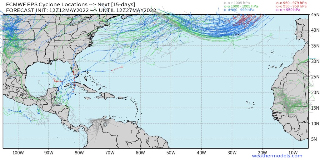
SFLcane wrote:Few eps members…
https://i.postimg.cc/KzfdtQv0/65-B22777-6185-4-ECB-8-AA4-5-BBB640-B6027.jpg
That's a decent number of EPS members including some strong ones, this might be more than a phantom possibly?
3 likes
-
AutoPenalti
- Category 5
- Posts: 4091
- Age: 29
- Joined: Mon Aug 17, 2015 4:16 pm
- Location: Ft. Lauderdale, Florida
Re: 2022 Global Model Runs Discussion (Out thru day 16)
timeframe for development hasn’t closed in nor has it pushed back
0 likes
The posts in this forum are NOT official forecasts and should not be used as such. They are just the opinion of the poster and may or may not be backed by sound meteorological data. They are NOT endorsed by any professional institution or STORM2K. For official information, please refer to products from the NHC and NWS.
Model Runs Cheat Sheet:
GFS (5:30 AM/PM, 11:30 AM/PM)
HWRF, GFDL, UKMET, NAVGEM (6:30-8:00 AM/PM, 12:30-2:00 AM/PM)
ECMWF (1:45 AM/PM)
TCVN is a weighted averaged
-
Kingarabian

- S2K Supporter
- Posts: 16359
- Joined: Sat Aug 08, 2009 3:06 am
- Location: Honolulu, Hawaii
Re: 2022 Global Model Runs Discussion (Out thru day 16)
GFS going to shock us all? Fool me once...
3 likes
RIP Kobe Bryant
-
AnnularCane

- S2K Supporter
- Posts: 2961
- Joined: Thu Jun 08, 2006 9:18 am
- Location: Wytheville, VA
Re: 2022 Global Model Runs Discussion (Out thru day 16)
AtlanticWind wrote:If this happened liked the GFS is showing I think the NHC would be moving up the start
of hurricane season to May 15th next year
I was actually thinking the same thing earlier today.
0 likes
"But it never rained rain. It never snowed snow. And it never blew just wind. It rained things like soup and juice. It snowed mashed potatoes and green peas. And sometimes the wind blew in storms of hamburgers." -- Judi Barrett, Cloudy with a Chance of Meatballs

Re: 2022 Global Model Runs Discussion (Out thru day 16)
SFLcane wrote:Few eps members…
https://i.postimg.cc/KzfdtQv0/65-B22777-6185-4-ECB-8-AA4-5-BBB640-B6027.jpg
How many members does the EPS have? 51?
0 likes
-
USTropics
- Professional-Met

- Posts: 2738
- Joined: Sun Aug 12, 2007 3:45 am
- Location: Florida State University
Re: 2022 Global Model Runs Discussion (Out thru day 16)
Cpv17 wrote:SFLcane wrote:Few eps members…
https://i.postimg.cc/KzfdtQv0/65-B22777-6185-4-ECB-8-AA4-5-BBB640-B6027.jpg
How many members does the EPS have? 51?
EPS medium-range (15 days) has 52 ensemble members—50 individual ensemble members, an HRES member, and a control member. The one member being designated for a higher spatial resolution is known as the HRES at ECMWF, sometimes referred to as the operational forecast/member by other agencies.
HRES essentially uses the most accurate estimate of real-time conditions and utilizes the best description of the model physics. The other members are given altered starting conditions, known as perturbations, to cover real-time variability and physics limitations. While the HRES in theory provides the most accurate description of weather forecasting (averages over an extended period of forecasts provides the most accurate skill at ~10 days), it may not be the most accurate member of the ensemble suite or over the course of a shorter period of forecasts (due to aforementioned variability/perturbed ensemble members and physics limitations).
The ensemble suite also contains a control member, which is run at a lower spatial resolution than the HRES. The control initializes with the same starting conditions, parameters, and model physics but its main function is to provide an unperturbed member (or starting base) for each ensemble member (which has perturbations applied). As such, the 50 perturbed members of the ensemble suite are similar to the control member, but their initial states and model physics are perturbed to provide a range of possible future weather states (they essentially provide a buffer to forecast uncertainty and confidence).
You can find daily and weekly scores here (https://apps.ecmwf.int/webapps/openchar ... 9%22%5D%7D)
4 likes
-
skyline385
- Category 5
- Posts: 2728
- Age: 35
- Joined: Wed Aug 26, 2020 11:15 pm
- Location: Houston TX
Re: 2022 Global Model Runs Discussion (Out thru day 16)
GFS 0Z going on a tour of the Gulf lol
0 likes
-
Category5Kaiju
- Category 5
- Posts: 4332
- Joined: Thu Dec 24, 2020 12:45 pm
- Location: Seattle and Phoenix
Re: 2022 Global Model Runs Discussion (Out thru day 16)
skyline385 wrote:GFS 0Z going on a tour of the Gulf lol
Not only that, it also shows a TS in the open subtropics by the end of the month lol
1 likes
Unless explicitly stated, all info in my posts is based on my own opinions and observations. Tropical storms and hurricanes can be extremely dangerous. Refer to an accredited weather research agency or meteorologist if you need to make serious decisions regarding an approaching storm.
-
Kingarabian
- S2K Supporter
- Posts: 16359
- Joined: Sat Aug 08, 2009 3:06 am
- Location: Honolulu, Hawaii
Re: 2022 Global Model Runs Discussion (Out thru day 16)
For the most part and regardless of strength, the models are now all agreeing on a system to form in about 5-7 days somewhere near central America. 00z GFS continues to favor a WCaribbean system. 00z Euro and CMC favor a eastern EPAC system.
3 likes
RIP Kobe Bryant

Re: 2022 Global Model Runs Discussion (Out thru day 16)
06z GFS has the CAG become a sheared and weak TS going through the Yucatán channel, which is a far more realistic solution than a strong TS or weak hurricane in the Caribbean. The timeframe continues to move closer, as the precursor area of rotation can be seen starting at 132-168 hrs out.
0 likes
Irene '11 Sandy '12 Hermine '16 5/15/2018 Derecho Fay '20 Isaias '20 Elsa '21 Henri '21 Ida '21
I am only a meteorology enthusiast who knows a decent amount about tropical cyclones. Look to the professional mets, the NHC, or your local weather office for the best information.
I am only a meteorology enthusiast who knows a decent amount about tropical cyclones. Look to the professional mets, the NHC, or your local weather office for the best information.
-
skyline385
- Category 5
- Posts: 2728
- Age: 35
- Joined: Wed Aug 26, 2020 11:15 pm
- Location: Houston TX
2022 Global Model Runs Discussion (Out thru day 16)
aspen wrote:06z GFS has the CAG become a sheared and weak TS going through the Yucatán channel, which is a far more realistic solution than a strong TS or weak hurricane in the Caribbean. The timeframe continues to move closer, as the precursor area of rotation can be seen starting at 132-168 hrs out.
While this is a far more realistic scenario, almost all of the ensemble members from the 6z run are still heading north towards LA and FL.
Historically this also seems to be the path May systems prefer
https://www.nhc.noaa.gov/climo/
0 likes
-
Category5Kaiju
- Category 5
- Posts: 4332
- Joined: Thu Dec 24, 2020 12:45 pm
- Location: Seattle and Phoenix
Re: 2022 Global Model Runs Discussion (Out thru day 16)
Is it just me, or did the signal for the potential EPAC system later next week greatly weaken? The GFS, CMC, and Euro (especially the GEFS) don't seem as excited about it as they were several days ago and prior.
1 likes
Unless explicitly stated, all info in my posts is based on my own opinions and observations. Tropical storms and hurricanes can be extremely dangerous. Refer to an accredited weather research agency or meteorologist if you need to make serious decisions regarding an approaching storm.
-
wxman57

- Moderator-Pro Met

- Posts: 23174
- Age: 68
- Joined: Sat Jun 21, 2003 8:06 pm
- Location: Houston, TX (southwest)
Re: 2022 Global Model Runs Discussion (Out thru day 16)
AtlanticWind wrote:If this happened liked the GFS is showing I think the NHC would be moving up the start
of hurricane season to May 15th next year
No, I don't think that they would. Since 1950, the average date of the first hurricane has moved from late July to early August. On only 3 occasions has a hurricane formed prior to June 1. In this case, the GFS is the only model predicting development. Not even a hint of development in the Euro or Canadian. That, and knowing the the GFS tends to spin up spurious hurricanes from the SW Caribbean in May, is a BIG red flag. Nothing, at present, to indicate that this is any more than a modelcane.

5 likes
Who is online
Users browsing this forum: No registered users and 33 guests